Tomčeva koča na Poljški planini - Roblekov dom na Begunjščici
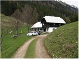
Starting point: Tomčeva koča na Poljški planini (1180 m)
| Latitude/Longitude: | 46,40850°N 14,20780°E |
| |
Walking time: 1 h 20 min
Difficulty: easy marked way
Elevation gain: 477 m
Elevation difference along the route: 477 m
Map: Karavanke - osrednji del 1:50.000
Recommended equipment (summer):
Recommended equipment (winter): ice axe, crampons
Views: 130.917
 | 7 people like this post |
Access to starting point:
From the Ljubljana - Jesenice highway, take the Radovljica exit (from the Gorenjska side, Lesce exit) and follow the road ahead in the direction of Begunje. At the end of the village Begunje, turn left towards the Dom v Dragi (right Tržič). The asphalt road then brings us to the parking lot near Dom v Dragi. We continue right on the road in the direction of Roblekov dom and Poljška planina. Further, we follow the relatively steep and occasionally worse road in the direction of Poljška planina, where we park on the marked parking lot near Tomčeva koča.
Route description:
From the parking lot, we walk to Tomčeva koča, where a signpost for Roblekov dom directs us onto a footpath that goes into the forest (at the spot where the marked path turns to the left, a short path branches off to the right, which leads to an old decaying - once mighty fir tree).
The path through the forest ascends moderately to steeply and soon brings us to the spot where a lot of logs are stacked. These logs are intended for heating Roblekov dom. If we are in the mood and have enough strength, we can take one to the hut (they will be very grateful).
The forest is becoming thinner and the path steeper. From the wide and well-made path, which is quite muddy after rain, nice views occasionally open up. The path then turns a little to the left and brings us to the spot where the path from the mountain pasture Preval joins from the right.
We continue on the left path, which after another 10 minutes of diagonal ascent brings us to the mountain hut.
Photos:
 1
1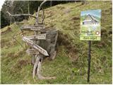 2
2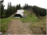 3
3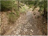 4
4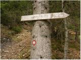 5
5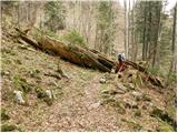 6
6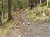 7
7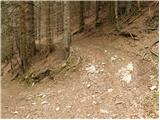 8
8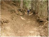 9
9 10
10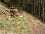 11
11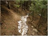 12
12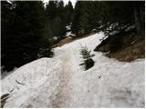 13
13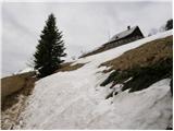 14
14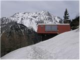 15
15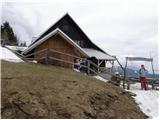 16
16
Discussion about the trip Tomčeva koča na Poljški planini - Roblekov dom na Begunjščici
|
| Gost24. 06. 2006 |
I also walked this path many years ago and it seems to me that there's a very old tree nearby. But I don't know which one it is.
|
|
|
|
| v19608. 07. 2006 |
This tree is a fir. Covered with moss, partially decayed, very mighty tree. A sign points to it a little above Poljska planina. On Poljska planina, they pour Italian milk from a tetrapak into your coffee, even though dairy cows are grazing in the enclosure. A pity.
|
|
|
|
| Gost29. 10. 2007 |
On the Alpine Association site it says "OSNP also still in October" - was at the hut on Saturday 27. 10. 2007 - closed and no stamps either.
|
|
|
|
| REKREATIVEC20. 07. 2008 |
I don't know where the 1:30 hours come from, we were there yesterday with the family, and arrived in less than 1 hour without any hard pace.
Wonderful view resembling paradise.
|
|
|
|
| MartinaZ21. 07. 2008 |
We also arrived in a little less than an hour, and we're not too fast.
|
|
|
|
| Kriška21. 07. 2008 |
As far as I know, the rule for hiking in the mountains still holds that approx. 300 elevation meters are covered in one hour. So the estimate (1.5 hours) based on the elevation difference is completely correct.
|
|
|
|
| ŠpelaD16. 06. 2019 |
From Draga onwards it's quite a rough road, catastrophic after rain. Choose if you have an off-roader or high ground clearance, otherwise it's a drama. Otherwise if you park halfway to Tomčeva, the path lengthens by 20'. Otherwise a fun trip, suitable for children.
|
|
|
|
| Ficla11. 01. 2020 |
Not possible to Tomčeva koča by car, the road has too many big potholes. We left the car in a spot by the road. The path itself is nice and undemanding, but not very scenic. However the view is very nice when you reach the destination. The path below the summit is a bit icy, so crampons would come in handy. In the hut they also have excellent ričet 
Nice trip, suitable also for children.
|
|
|
|
| Ficla11. 01. 2020 |
Not possible to Tomčeva koča by car, the road has too many big potholes. We left the car in a spot by the road. The path itself is nice and undemanding, but not very scenic. However the view is very nice when you reach the destination. The path below the summit is a bit icy, so crampons would come in handy. In the hut they also have excellent ričet
Nice trip, suitable also for children.
|
|
|
|
| Gringos226. 09. 2020 |
Pleasant path also for children.
|
|
|
|
| hribovc7620. 02. 2021 |
Hello, tomorrow we plan to go to Roblekov dom from Draga or from Tomčeva koča with the family. We don't have an off-road vehicle and I'm wondering how far we could get below Tomčeva koča and how long it would take us to get there? Is the path drivable?
Thank you very much, Jan
|
|
|
|
| Barbara 7525. 08. 2023 11:06:04 |
Hi, interested in road passability to Poljska planina or rather the hut in Draga, thanks for info
|
|
|
|
| bongo25. 08. 2023 11:50:10 |
All paths from Draga to Roblek and Preval are officially closed, as the disaster damaged or washed away the road. It's in the notices here and on pzs.si (Stanje poti)
|
|
|
|
| mv-6324. 09. 2023 20:38:37 |
The road is now passable, but they've thoroughly set up transverse drainage channels, so it's almost impassable for ordinary passenger vehicles.
|
|
|
To post a comment you must log in:
If you do not yet have a username, you must first
register.