Travna Gora - Koča na Kamnem griču
Starting point: Travna Gora (950 m)
| Latitude/Longitude: | 45,73610°N 14,64420°E |
| |
Walking time: 45 min
Difficulty: easy marked way
Elevation gain: 66 m
Elevation difference along the route: 140 m
Map:
Recommended equipment (summer):
Recommended equipment (winter):
Views: 21.878
 | 1 person like this post |
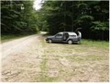
Access to starting point:
We drive on a regional road from Ljubljana towards Kočevje or vice versa. At the village Žlebič we will notice signs for Nova Štifta and Sodražica, which direct us to the right (from Kočevje and Ribnica, left). We drive further to the village Lipovščica, where a sign for Nova Štifta directs us left uphill on an ascending road. The road then quickly brings us to Nova Štifta, where we notice signs for Travna Gora. Further, we ascend on a macadam road which brings us higher to the mentioned village. We continue driving in the direction of the hut at Travna Gora, from where we continue on the right road which soon brings us to the parking lot near the signposts (second footpath, at the first one there are only blazes and inscription on a tree, at the second footpath there are also signposts. Starting points are approximately 500m apart).
We can also arrive at the starting point from the direction of the road Hrib-Loški Potok - Sodražica. From the mentioned road, where the turn-off is marked, it is approximately 5 km of macadam to the Dom na Travni Gori.
Route description:
From the parking lot, we head on the path in the direction of the mountain hut Koča na Kamnem griču. The path initially ascends on a gentle and usually quite muddy cart track, which already after a few minutes ascends more steeply. When the steepness eases we come to a poorly marked junction, where we continue right. We continue walking on a wider but poorly marked cart track, which after a short descent changes into a macadam road, which quickly brings us to the next junction. We continue left on the poorer macadam road in the direction of Kamni grič. At a smaller turning point the road changes into a cart track, and here we continue straight (poorly marked) on a pleasant cart track which from the forest brings us to nice grassy slopes. On the other side of the meadow we come to a marked junction, where we continue right in the direction of the mountain hut, to which we have still 5 minutes of ascent on a moderately steep cart track which ascends over the previously mentioned meadow.

Photos:
 1
1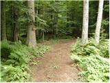 2
2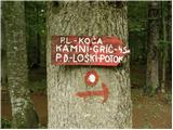 3
3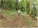 4
4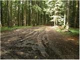 5
5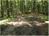 6
6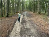 7
7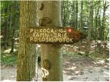 8
8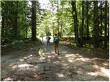 9
9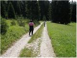 10
10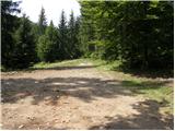 11
11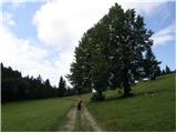 12
12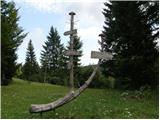 13
13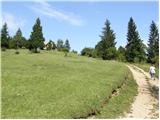 14
14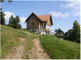 15
15 16
16
Discussion about the trip Travna Gora - Koča na Kamnem griču
|
| brezjan25. 04. 2011 |
I was at Travna Gora and Kamen grič on 23.04.11. The route description helped me a lot to find the right path to the hut at Kamen grič. When coming from the forest road to the macadam path, the markers get a bit lost or are scattered on several sides. The path needs to be continued along the macadam to the junction, where there's also a sign directing to the hut. The hut at Kamen grič is closed.
I also stopped at Dom na Travni gori, which according to the notice on the door should be open from 9 o'clock onwards. I was at the hut at 11.40 but everything locked and no living soul anywhere.
Nice path especially in spring when everything turns green, but regarding Dom na Travni gori criticism from my side - unreliability of the caretakers.
|
|
|
|
| brezjan25. 04. 2011 |
Printer's goblin; The hut should be open from 9.00 onwards.
|
|
|
|
| navrhu1. 11. 2014 |
Is there no other trail to Kamni grič besides from Travna Gora? Maybe from Mali log?
|
|
|
|
| simon791. 11. 2014 |
Of course there are other trails. Both from Mali Log and from Gora (Kržeti). Time is similar for both, good half hour...
|
|
|
|
| lumi8. 04. 2015 |
How is the hut at Travna Gora open?
|
|
|
|
| lumi8. 04. 2015 |
I need the stamp for the couriers' and signallers' path - is it only in the hut or also outside?
|
|
|
|
| JusAvgustin8. 04. 2015 |
Depends. Are you partisan or German? Germans were in the houses, partisans hid outside - in the forest... Germans were in the houses, partisans hid outside - in the forest...
|
|
|
|
| hribovc714. 02. 2017 |
Is there any snow up there currently?
|
|
|
|
| uros.tanko@gmail.com14. 02. 2017 |
On Saturday there was just enough snow to make it white - about 5 cm.
|
|
|
To post a comment you must log in:
If you do not yet have a username, you must first
register.