Tremerje - Dom na Šmohorju
Starting point: Tremerje (242 m)
Walking time: 2 h
Difficulty: easy marked way
Elevation gain: 542 m
Elevation difference along the route: 750 m
Map:
Recommended equipment (summer):
Recommended equipment (winter):
Views: 9.821
 | 2 people like this post |
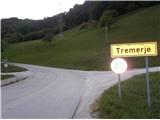
Access to starting point:
Tremerje is a settlement between Celje and Zidani Most. From the direction of Celje, we turn right and near the settlement sign there are available parking spots. In the opposite direction there is a bridge over Savinja. From the direction of Zidani Most or Laško we turn left and near the settlement sign there are available parking spots. Accessible also with the help of a bus, bus stop Tremerje.
Route description:
From the parking spot, we go towards the center of the settlement Tremerje, where there is probably the most important point, the church of St. Luke. To the turn-off for Veliki Slomnik we can continue on the asphalt road, where the path is marked or we can turn left a little lower on a well-hardened gravel road along the fields and meadows, pastures, which still before the crossing Tremerje or turn-off for Veliki Slomnik joins again. After the turn-off for Veliki Slomnik, we follow the asphalt path for good two hundred meters, all the way to the former well-known underpass Tremerje, which years ago was causing problems - mainly because of the floods and narrow passage.
A little before the underpass, we continue along the homestead sharply right upwards on a macadam path, solidly hardened and we follow the road between the lonely homesteads. The blazes in this part are less frequent, signposts are there and further we proceed to a forest path, partly also a cart track, which we follow to the left, more steeply upwards to the right. We again join a macadam road, perhaps also a forest road and turn sharply left, from the right also the path from Liboj joins. We follow the forest road and it rises pleasantly to the abandoned homestead, where we turn through the yard quite sharply right upwards and below another homestead and by the holiday cottage, we step onto the plain to a crossroad.
We continue again sharply left upwards and the surface is very pleasant and finally a proper hiking forest path. We follow the path, in this part it is excellently marked, the path is varied in not too strenuous ascent. On this part the path leads also over the peak without a name at height 861, further a short section through grassy/pasture plain and after a short section through the forest from the right another hiking path from Liboj joins us. A few more steps, right a little downwards and by the building under construction there is a junction with the path which leads left to Malič. A few more meters to the structure in ruins, also a path junction, a little upwards through the forest and we reach the destination – Dom na Šmohorju.

Photos:
 1
1 2
2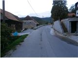 3
3 4
4 5
5 6
6 7
7 8
8 9
9 10
10 11
11 12
12 13
13 14
14 15
15 16
16 17
17 18
18 19
19 20
20 21
21 22
22 23
23 24
24 25
25 26
26 27
27 28
28 29
29 30
30 31
31 32
32 33
33
Discussion about the trip Tremerje - Dom na Šmohorju
|
| šoni10. 06. 2016 |
from the Tremerje underpass to the last house and the chapel above it, no need to go by road because there is a nice forest path along the ridge of Mali Slomnik on the right side of the stream in the direction of the hike, that is, before that last house right onto the gravel and out of it - when it turns a bit higher to a house, go left into the forest.
|
|
|
To post a comment you must log in:
If you do not yet have a username, you must first
register.