Starting point: Tri studničky (1140 m)
| Latitude/Longitude: | 49,13452°N 19,96894°E |
| |
Walking time: 4 h
Difficulty: partly demanding marked way
Elevation gain: 1354 m
Elevation difference along the route: 1355 m
Map:
Recommended equipment (summer):
Recommended equipment (winter):
Views: 1.800
 | 2 people like this post |
Access to starting point:
The best route from Slovenia runs past Graz, Vienna, Bratislava, Nitra and Banska Bystrica over the Donovaly Pass into Ružomberok and then towards Poprad (E50), but soon at the Liptovski Hradok exit we leave the highway and on the "Road of Freedom" (537) through the village Pribylina, near which there is also an important ethnological settlement, we drive to the Tri studničky parking lot, where we park at a paid parking lot.
Route description:
On the eastern side of the parking lot, we turn left and ascend about 150 meters uphill on a road that is initially still asphalt (next to it there are additional parking lots). At the signs on which it is written that it is 4 hours to the top of Kriváň, we turn left and continue on the path that runs alongside the road by which we came to the parking lot, slightly downhill. After approximately 600 meters we arrive at an old forestry cottage. We can also reach here from the parking lot by going back along the road in the direction from which we came and turning right onto the path just described a little before the first bend. At the forestry cottage, by the signposts, there are some benches for (too early) rest and water. Looking at the signposts, we are surprised to find that we are already half an hour closer to the goal, as the signs indicate only 3 hours and 30 minutes to the top. We turn right onto the green-marked path towards the northwest. The path becomes steeper and ascends in zigzags past the partisan bunker below Grúnik (1576 m). Out of the forest we reach slopes covered with dwarf pines, between which the path continues to ascend in zigzags. When we leave this belt of dwarf pines, a view of Kriváň opens up in front of us. To the right of the peak we spot a junction into "Krivánskom žľabe", but we still have quite a way to go there. Above the path is Vyšná priehyba (1982 m), while we ascend diagonally below the ridge towards the gully that descends from below Mali Kriváň (2334 m) into the valley. At the junction there is also a signpost on which we read that only 1 hour and 15 minutes of walking separate us from the top. From the green-marked path we step onto the blue path, which first heads left, then right into the gully and through the gully a little further right onto a more consolidated rocky slope. The old path followed the gully but it was rerouted to the right due to unstable rocks; many visitors, however, still ascend to the saddle between Mali Kriváň and Kriváň directly up the gully. The difficulty of the path increases slightly in this solid and reliable rocky terrain. Soon we step onto the southern ridge and first ascend along it to Mali Kriváň (2334 m). From the top we descend to Daxnerovo sedlo, to which the unofficial old path through the gully also leads. We continue straight ahead, ascending along the ridge for a while longer, then leave the ridge, turn slightly left, and with the aid of easy scrambling on the rocky flank ascend to the top. Since it is a kind of Slovak "Triglav", there are many hikers on this peak in the summer season. Therefore, it is good to think about an early start. The parking lot at the starting point is often full already before 5:00 a.m.

Along the route: Grúnik (1576m), Vyšná priehyba (1982m), Razpotje v Krivánskom žľabe (2120m), Malý Kriváň (2334m), Daxnerovo sedlo (2325m)
Photos:
 1
1 2
2 3
3 4
4 5
5 6
6 7
7 8
8 9
9 10
10 11
11 12
12 13
13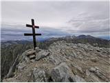 14
14
Discussion about the trip Tri studničky - Kriváň
To post a comment you must log in:
If you do not yet have a username, you must first
register.