Zgornja postaja žičnice na Ankogel - Ankogel
Starting point: Zgornja postaja žičnice na Ankogel (2636 m)
| Latitude/Longitude: | 47,01480°N 13,18530°E |
| |
Walking time: 3 h
Difficulty: difficult marked way
Elevation gain: 616 m
Elevation difference along the route: 670 m
Map:
Recommended equipment (summer): helmet
Recommended equipment (winter): helmet, ice axe, crampons
Views: 41.828
 | 3 people like this post |
Access to starting point:
From Ljubljana through the Karawanks Tunnel to Spittal. We continue driving towards Lienz, but only to the settlement Möllbrücke. In the mentioned settlement we notice signs for Mallnitz and the alpine road to Großglockner. We follow this road to the settlement Obervellach, where signs for Mallnitz direct us to the right. Behind the village, the road starts to ascend more steeply and after a few kilometers of ascent brings us to the alpine town of Mallnitz. We then drive a few more kilometers to the lower cable car station on Ankogel (Ankogelbahn), where we park in a large parking lot. Then we buy a ticket and take the cable car to the upper cable car station on Ankogel.
Route description:
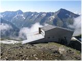
From the upper station, we continue straight in the direction of Hannoverhaus, and to the right runs the direct and a few minutes shorter path towards Ankogel. From the upper station of the cableway, we have about 15 minutes of ascent to the hut.
At the hut, we follow the signs for Ankogel. First, we descend slightly to a smaller saddle where we turn right, the left path leads towards the peaks Grauleiten and Plattenkogel. A few meters below the saddle we come again to a junction where the direct path from the upper station of the cableway joins from the right. This time we go left and then in a gentle descent cross the southern slopes below the mentioned peaks. When we come to the signposts we continue straight in the direction towards Ankogel. After a few minutes of walking, we come again to the signposts where we turn left following the signs for Ankogel. After a short ascent on a relatively gentle slope, the path turns slightly to the left and starts ascending beside the glacier Lassacher Kees. The glacier is relatively gentle and has no crevasses. The path then turns to the left again and ascends towards the notch Radeck Scharte. At the notch, we turn right and along the rocky ridge reach the summit Kleine Ankogel. The ridge from the notch towards the summit is slightly exposed in a few places but does not cause problems when dry.
From the summit, we turn left and continue along the main ridge. The path towards the summit Ankogel then runs along the right side of the ridge and becomes somewhat more demanding. The eastern slope of Ankogel along which we ascend is quite steep and in a few places also dangerous for slipping. We also need to be careful because the granite slabs along which we ascend are not all the most stable. Towards the summit the path then turns slightly to the left and brings us to the cross and summit register box. We reach the true summit if we continue a few dozen meters further along the exposed ridge from the cross.

Photos:
 1
1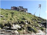 2
2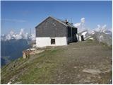 3
3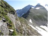 4
4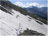 5
5 6
6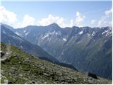 7
7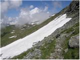 8
8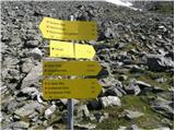 9
9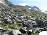 10
10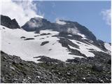 11
11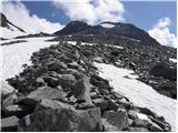 12
12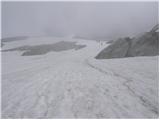 13
13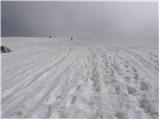 14
14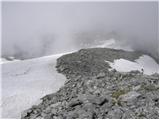 15
15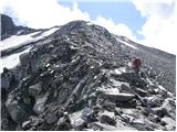 16
16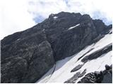 17
17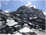 18
18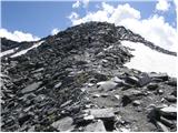 19
19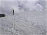 20
20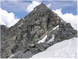 21
21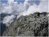 22
22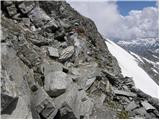 23
23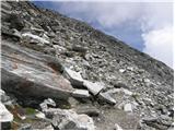 24
24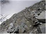 25
25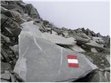 26
26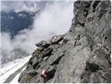 27
27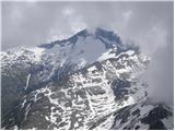 28
28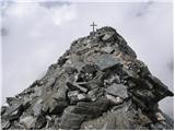 29
29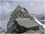 30
30
Discussion about the trip Zgornja postaja žičnice na Ankogel - Ankogel
|
| ljubitelj gora11. 07. 2013 |
Last August a large group of hikers gathered and we set off along the described route to Ankogel. In the morning we met at the gas station in Jesenice, got to know each other, had some drinks, then drove to Austria. Since there were many of us and it's a long way there, we took the gondola up to the upper cable car station. The weather favored us, exceptional views extended very far, we definitely had a great time and at this moment I would like to thank the initiators for this excellent trip. I uploaded more photos last year to the online album: https://plus.google.com/photos/114400986607884783562/albums/5778339238119557073
|
|
|
|
| Grega921. 09. 2013 |
hi
I'm wondering what the conditions are like now?
|
|
|
|
| VanSims1. 09. 2013 |
Yesterday from Hafner it looked completely covered in snow!  OK, that's the north side with the glacier. OK, that's the north side with the glacier. 
Otherwise the summit was a bit weathered, consequence of last week's precipitation. Today it might snow up there again, next week summer is forecast again. I'd say up to Tuesday, wait until Wednesday then you can go if nothing falls again.
The normal route described above, which I assume you're taking, runs along the SW ridge.
|
|
|
|
| bostjanp2. 09. 2013 |
I was up there on Saturday, 31.08., summit in fog in the morning, but wind and thermals blew everything away by 12 during the day. The ascent path was in the section from the snowfield to Little Ankogel covered with partially frozen snow in several places, but still passable without crampons, to the summit a bit cleaner, but secure step required. On descent, the snow had nicely softened, but still careful. How it will be now after a few days of bad weather... expect snow up there, put winter gear in your backpack, no one will give you side glances, it's about your safety anyway, not others' opinions or mockery. Nice up there, just the weather has to be ok.
|
|
|
|
| Lunca1. 07. 2015 |
Has anyone been up there these days?
|
|
|
|
| nisa6. 07. 2015 |
I'm also interested if anyone has been up there, and what the conditions are like. Maybe someone knows how many hours drive from Ljubljana to the lower station of the cable car to Ankogel, and what the return ticket price is.
|
|
|
|
| Lunca6. 07. 2015 |
My colleague and I were there yesterday... conditions are super, we had winter gear with us but didn't need it, that most exposed traverse is dry. On the way back we nicely shortened the path via snowfields  Helmet is useful below the summit, which is really scree and if someone climbs in front of you you can quickly get hit by something. From LJ via AC about 2.5h drive, return ticket is 25 EUR. Check the weather on bergfex website first so you don't drive so far for nothing, and the views are really wonderful. Good luck! Helmet is useful below the summit, which is really scree and if someone climbs in front of you you can quickly get hit by something. From LJ via AC about 2.5h drive, return ticket is 25 EUR. Check the weather on bergfex website first so you don't drive so far for nothing, and the views are really wonderful. Good luck!
|
|
|
|
| mpp18. 07. 2015 |
WARNING:
the new Hannoverhaus (opened 2014) is located 70 vertical meters below the upper cable car station.
Older descriptions and maps mention the old one,
which was above the station at the chapel.
condition July 2015
first gondola ride at 8:30, up at 9:00 (a bit late, sun is high, better to sleep in the hut the night before and start early to the summit) 25 EUR return adult
trail without special features (winter gear stayed in the backpack), in wet it must be quite "tricky"
|
|
|
|
| zacif5. 08. 2016 |
Hello!
Is anyone perhaps going to Ankogel and can I join you?
LPP Franc
|
|
|
|
| haridautovic1. 09. 2017 |
27.08.2017,,On Sunday we were on Ankogel,, Upper cable car station at Ankogel--Return ticket costs 29€,,paid with visa card,,don't know if there's difference between cash and card//First gondola at 8:30,,last from top at 16:20,,path very nicely marked,,even over glacier no problem,,no need for helmet and self-belay kit,,just watch granite slabs/blocks/ some very unstable,,views from top indescribable,,all 3000ers and countless lakes,,
|
|
|
|
| mrcepindereze7. 06. 2018 |
Hello!
Is anyone going to Ankogel this year and could I join them?
Best regards, Domen
|
|
|
|
| vrana9. 06. 2018 |
Hello,
I would also gladly join if someone is going to Ankogel.
Best, Maja
|
|
|
|
| zorkob1. 10. 2018 |
Hello,
Yesterday, 30.09.2018, my wife and I were at the summit. We started from the upper cable car station. The cable car costs 59 euros (for two people). The price includes 10 euros deposit for the card, which you get back upon return. So the price is 24.5 €/person. First ride at 8:30, last return at 16:20.
The path is sometimes poorly marked in the middle section and you can easily stray among the granite slabs. In the morning near the glacier in the middle part of the path (where we strayed from the marked trail) the slabs were icy and I slipped on one quite "childishly". Surefootedness required! Unfortunately, due to the granite, you can't tell if it's ice or granite shining??!! Otherwise a relatively technically undemanding tour. Nice views from the top and quick access/descent. It took us about 2h to the summit and 2h back.
In my opinion, helmet and via ferrata set are not necessary... a matter of personal judgment.
Regards, Boštjan
|
|
|
|
| LEA ŠTUMBERGER18. 02. 2019 |
16.2.2019, SATURDAY
We headed to Ankogel.
First to the upper station, then nicely onwards to the summit. Terrain nothing special, for early February extremely warm, snow turned into one big alpine puddle.
Some from the group skied, some hiked. Skiers descended the western side of the mountain to Böckstein, which offers almost 2000m of descent skiing.
TRAIL DESCRIPTION AND PHOTOS - HERE
|
|
|
|
| Paglia2. 08. 2020 |
Yesterday we took the gondola to the upper station and did this tour. The return ticket price is 28 eur; for seniors (over 60) 25 eur. First gondola at 8:30.
Nice tour with great views, little snow, you really don't need winter gear, just poles and a helmet from Kleine Ankogel to the summit is not bad.
The path to Kleine A. is completely easy, then you need to be a bit more careful as the path ascends quite steeply to the summit, but it's wide enough for those with some high mountain experience.
|
|
|
|
| GasperP25. 12. 2023 12:04:53 |
Hi,
Does anyone know how long the ride to the upper station takes?
|
|
|
|
| turbo25. 12. 2023 17:40:05 |
|
|
|
|
| drugi žagar10. 12. 2025 16:30:22 |
Would you say that the trail from the cable car station is harder or easier than, say, the trail to Grintovec via Mlinarsko sedlo (in terms of technical difficulty and exposure). I plan to ascend in summer and am interested in the approximate difficulty. Thanks
|
|
|
To post a comment you must log in:
If you do not yet have a username, you must first
register.