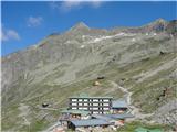
Zgornja postaja gorske železnice - Grosses Reisseck
Starting point: Zgornja postaja gorske železnice (2245 m)
Walking time: 2 h
Difficulty: partly demanding marked way
Elevation gain: 740 m
Elevation difference along the route: 750 m
Map:
Recommended equipment (summer): helmet
Recommended equipment (winter): helmet, ice axe, crampons
Views: 12.950
 | 2 people like this post |
Access to starting point:
From Slovenia we first drive to Beljak / Villach, further to Spittal and then towards Lienz. Already a few kilometers before the place Möllbrucke we turn right onto the road towards Grossglockner and Mallnitz. Soon we reach the lower lake of the hydropower plant Reisseck, which is on the left and immediately into the settlement Kolbnitz (Unterkolbnitz), where green signs direct us to the right towards Reisseck Bergbahnen. We then drive a few more bends through the mentioned settlement and arrive at the parking lot at the lower station of the mountain railway, which takes us to the starting point.
Route description:
At the upper station of the mountain railway we first follow a narrow road and already after a few meters we notice the first yellow signposts, which point to the right towards Hohe Leier and Hochkedl, and the hut Reisseckhütte, which we see right below the concrete dam. If we don't want to go to the hut (10 min), we continue the path along the narrow road, where we come to a sign with markings that direct us left to the walking path to Reisseck. Here the path from the hut also joins. Further we follow the markings along a partly rocky wide ridge, scattered with numerous stone cairns, and left below we notice the upper reservoir lake, closer to which the path then descends a little. Above the shore of the lake we cross the slope and arrive at the steep slope below the saddle Riekentörl. Here the path ascends in switchbacks over smaller rocky steps, and if we are on the path when there is still some snow in the mountains we also cross numerous streams and right below the saddle some snow fields (if they are smaller we bypass them without difficulty). When we arrive at the saddle a view opens towards the east onto a wide valley with numerous lakes and a chain of mountains above them, and the first view of our goal, which peeks from the north over the slope in front of it. Here a signpost with a white board directs us right. Already after a few meters we must pay attention to the white inscription on the stone (Reisseck) and the markings, which lead the path left over the rocky slope, because more trodden is the directly ascending unmarked track that goes to Radleck (2802). We walk all the time westward below the ridge between Radleck and Reisseck, and the path is well laid out over large stones, which are partly arranged into ledges and steps for easier walking. Also here we can encounter steep snow fields, which we must cross, and we watch that we don't slip or that our foot doesn't get stuck in some hole among the rocks. After a little more than one hour of walking from the starting point we reach the narrow saddle Kalte Herberg-Scharte, over which towards the east steeply below we notice a cirque with a lake and depending on the season also a large snow field above it. From there a visibly less trodden path from the Malta valley via the hut Zottachütte joins at the saddle. Now we ascend into the summit pyramid of Reisseck. All the time we walk over rocky ledges, from the start also somewhat closer to the smaller precipice above the aforementioned snow field, which we don't approach if we don't step somewhat off the path. The steepness is considerable here, so we progress more slowly than on the previous part of the path. Since we walk over rocks that are more or less in place we step carefully during walking so that the stones don't shift and that we don't dislodge them towards the hikers behind us, because the ascent proceeds more or less straight upwards. After less than an hour we reach the summit with a cross. Here on the metal box with the logbook a sign surprises us: Grosses Reisseck 2985 m. (on the maps and signs below it is written 2965 m).

Along the route: Reisseckhutte (2287m), Riekentörl (2560m), Kalte Herberg-Scharte (2712m)
Photos:
 1
1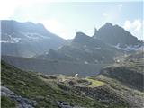 2
2 3
3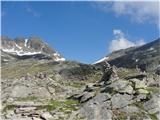 4
4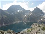 5
5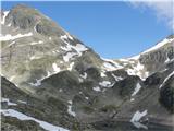 6
6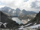 7
7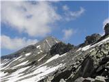 8
8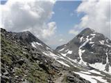 9
9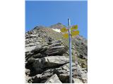 10
10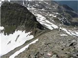 11
11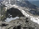 12
12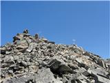 13
13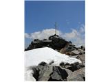 14
14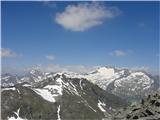 15
15
Discussion about the trip Zgornja postaja gorske železnice - Grosses Reisseck
|
| JORDAN5. 10. 2011 |
31.09.2011 my friend and I climbed to Grosses Reisseck - 2965m. The price of a return ticket for Reisseck Bergbahn is 18.50€ per person. When purchasing a return ticket, you need to tell the seller when you return, because the railway is not circular and accepts a limited number of passengers and thus you get a ticket for the exactly specified return. Weather without clouds and also without wind. The tour is suitable for everyone, even if not going to the top of Reisseck; you can walk around the reservoir lakes, only the ascent along the summit ridge is a bit exposed.
|
|
|
|
| serznoz26. 09. 2018 |
The cable car or the subsequent tunnel is being renovated and the described starting point of the path is not usable. Access to the destination is possible from Reisseck via the Geißrücken valley over Zandlacher Hütte or from Lendorf via the valley over Kohlmaier Hütte.
|
|
|
|
| jax26. 09. 2018 |
As far as I know, they are not even renovating it, but they will discontinue it altogether for passenger transport. Sad, but such things happen in Austria too...
|
|
|
To post a comment you must log in:
If you do not yet have a username, you must first
register.