Uskovnica (Lom) - Ablanca (via planina Spodnji Tosc)
Starting point: Uskovnica (Lom) (1076 m)
| Latitude/Longitude: | 46,31330°N 13,90540°E |
| |
Route name: via planina Spodnji Tosc
Walking time: 3 h 40 min
Difficulty: difficult unmarked way
Elevation gain: 928 m
Elevation difference along the route: 1130 m
Map: TNP 1:50.000
Recommended equipment (summer): helmet
Recommended equipment (winter): helmet, ice axe, crampons
Views: 1.120
 | 1 person like this post |
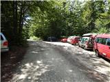
Access to starting point:From the Ljubljana - Jesenice motorway, take the Lesce exit and follow the road towards Bled and further towards Bohinjska Bistrica. Just before Bohinjska Bistrica, at the settlement of Bitnje, continue sharply right towards Pokljuka. After a short ascent, the road levels out and quickly brings us to the Upper Bohinj Valley. At the junction here, continue left (right to Pokljuka) and follow the road further to Srednja vas. In the second part of the village, notice the signs for Uskovnica (7 km), which direct us right onto a narrower road, initially still asphalted. Follow this road, which ascends most of the way, to the "Lom" parking lot, where there is a sign prohibiting further driving (further driving permitted only to landowners).
Traffic regime in the Pokljuka and Uskovnica area from June 15 to October 15.
Route description:
From the parking lot, continue towards Koča na Uskovnici along the road, after which we quickly emerge from the forest, where we see signs for cheese, milk, and homemade products. A few dozen meters further, a short path branches left from the road to the nearby sirarna pr Ulčnek, where during grazing season we can buy the mentioned products; otherwise continue straight to the marked junction a few steps away, continuing right towards Koča na Uskovnici. The path first passes a landmark (cross), then continues between pastures. When the pastures end on the right, a marked path from Srednja vas (path "Za Ribnico") joins from the right.
Continue straight, then past weekend cottages reach a water trough and a few steps further to the spot where signs for the familiar hut direct us left onto a cart track. Followed by a short ascent on the cart track, bringing us to Koča na Uskovnici.
From the hut, proceed towards Tosc, Draški vrh, Viševnik, Vodnikov dom, Rudno polje, and Praprotnica on the path that first crosses a pasture fence, then quickly joins a gravel road, which we follow right. The road leads between hummocky meadows, then after crossing the next fence we quickly reach a junction by the chapel of Mary Queen of Peace on Uskovnica.
Past the chapel, continue left (straight to planina Konjščica, right to Rudno polje) on the level road across extensive Uskovnica meadows, then the path reaches the forest edge, turning into an initially wide cart track. The cart track, starting a moderate ascent ahead with some junctions, we follow towards Vodnikov dom na Velem polju and Triglav. Higher, the cart track through forest turns into a footpath, quickly leading to a pleasant spring under Mesnova glava called Štapce. At the spring continue straight (right to hunting hut) and ascend on a gentle path that soon reaches steep slopes. Shortly after, fixed protections help crossing a steep gully. The path continues over fairly steep slopes dangerous for slipping when wet. During the crossing, the path steeply ascends briefly several times then descends. In the final part, cross very steep gullies on locally destroyed path (high slipping risk). The crossing ends at a larger streambed (usually spring) after which we enter softer grassy terrain.
Followed by a few minutes of easy walking, reaching abandoned planina Spodnji Tosc. The path ahead ascends moderately, soon to a minor junction where sharply right (straight old partly abandoned path) on a well-followable trail. The path steepens, quickly from sparse forest belt into shrubs, turning leftward. Soon levels, from shrubs to grassy slopes, ascending in minutes to Pokljuka - Triglav path.
Follow it right, soon to where path to Tosc branches left (marked junction, unmarked path). Continue straight on pleasant traverse from Tosc slopes gradually to Veliki Draški vrh slopes. Scenic path reaches foot of Studorski preval, steeply ascending briefly. After five minutes reach Studorski preval with marked junction.
At the pass, leave markings, go right uphill on narrow path (left Veliki Draški vrh, slightly left Srenjski preval, straight down Pokljuka). Quickly to scree where stones can be triggered, caution. Steeper path to ridge. Follow this slippery path (sliding sand) to Ablanca summit.
Start - Koča na Uskovnici 0:15, Koča na Uskovnici - chapel on Uskovnica 0:05, chapel on Uskovnica - Štapce 0:50, Štapce - Planina Spodnji Tosc 1:15, Planina Spodnji Tosc - Planina Zgornji Tosc 0:30, Planina Zgornji Tosc - Studorski preval 0:40, Studorski preval - Ablanca 0:20.

Photos:
 1
1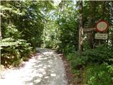 2
2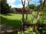 3
3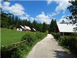 4
4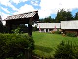 5
5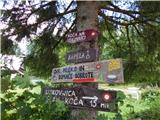 6
6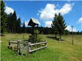 7
7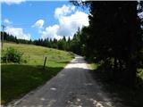 8
8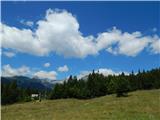 9
9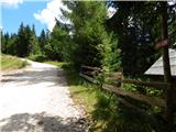 10
10 11
11 12
12 13
13 14
14 15
15 16
16 17
17 18
18 19
19 20
20 21
21 22
22 23
23 24
24 25
25 26
26 27
27 28
28 29
29 30
30 31
31 32
32 33
33 34
34 35
35 36
36 37
37 38
38 39
39 40
40 41
41 42
42 43
43 44
44 45
45 46
46 47
47 48
48 49
49 50
50 51
51 52
52 53
53 54
54 55
55 56
56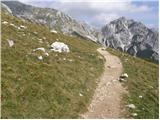 57
57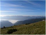 58
58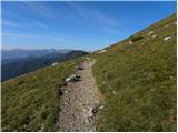 59
59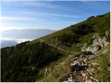 60
60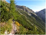 61
61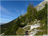 62
62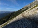 63
63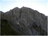 64
64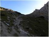 65
65 66
66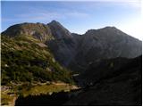 67
67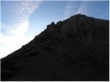 68
68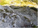 69
69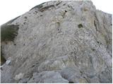 70
70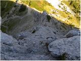 71
71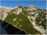 72
72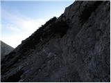 73
73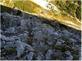 74
74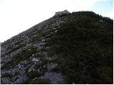 75
75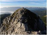 76
76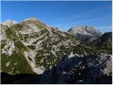 77
77
Discussion about the trip Uskovnica (Lom) - Ablanca (via planina Spodnji Tosc)
To post a comment you must log in:
If you do not yet have a username, you must first
register.