Uskovnica (Razpotje) - Tosc
Starting point: Uskovnica (Razpotje) (1215 m)
| Latitude/Longitude: | 46,32670°N 13,91070°E |
| |
Walking time: 3 h 55 min
Difficulty: difficult marked way, easy unmarked way
Elevation gain: 1060 m
Elevation difference along the route: 1200 m
Map: Triglav 1:25.000
Recommended equipment (summer):
Recommended equipment (winter): ice axe, crampons
Views: 37.287
 | 1 person like this post |
Access to starting point:a) Leave the Gorenjska motorway at the Lesce exit, then follow signs for Bled and Pokljuka. Continue through Gorje and past the Zatrnik ski slope to Rudno polje on Pokljuka, where there is a large paid parking lot, nearby also a military barracks and shooting range. From here continue straight on the gravel road, which a little further brings us to a junction, where we continue left towards Uskovnica (right planina Konjščica). From here drive another good 500 m to the former parking lot above Uskovnica. This area is called Razpotje.
Now parking is prohibited at the mentioned parking lot, so we must park already at Rudno polje, which extends the route by about 35 minutes, or choose the starting point Uskovnica (Lom).
b) From Železniki or Podbrdo drive to Bohinjska Bistrica, then continue driving towards Bled. Shortly after the Petrol gas station, located just a little after Bohinjska Bistrica, continue left towards Pokljuka and Jereka. The road first climbs steeply, then after Koriti gradually flattens and brings us to a junction at the bus station, where we continue right towards Pokljuka, Koprivnik and Jereka (straight Srednja vas). Immediately after the junction we arrive in Jereka; from the junction in front of the church, we continue straight towards Pokljuka (left Podjelje). After Jereka the road begins to climb more steeply again, higher it flattens and continues along Mrzli potok. When we join the road from Bled we go left and drive to Rudno polje, where there is a large paid parking lot, nearby also a military barracks and shooting range. From here continue straight on the gravel road, which a little further brings us to a junction, where we continue left towards Uskovnica (right planina Konjščica). From here drive another good 500 m to the former parking lot above Uskovnica. This area is called Razpotje.
Now parking is prohibited at the mentioned parking lot, so we must park already at Rudno polje, which extends the route by about 35 minutes, or choose the starting point Uskovnica (Lom).
Traffic regime in the Pokljuka and Uskovnica area from 15.6. to 15.10.
Route description:
From the former parking lot at the junction continue on the forest road closed to public traffic, which starts descending more steeply towards the gorge of the Ribnica stream. After a short descent we reach the mentioned gorge, over which a wide car bridge leads. The road flattens after the bridge and after a few minutes of further walking brings us out of the forest onto the vast meadows of Uskovnica.
Here we walk to the nearby chapel, then continue the path slightly right on the road that runs right next to the mentioned chapel (left Koča na Uskovnici, right planina Konjščica).
The fairly level road leads us further across the extensive meadows of Uskovnica, then brings us to the edge of the forest, where it starts changing into a initially still wide cart track. The cart track, which further starts ascending moderately has some junctions, we follow it in the direction of Vodnikov dom on Velem polju and Triglav. Higher the cart track, which mostly runs through forest, changes into a footpath, which quickly brings us to the pleasant spring under Mesnova glava called Štapce. At the spring continue straight (right hunting hut) and continue the ascent on the gentle path, which a little further brings us to steep slopes. Already soon after arriving at the steep slopes, fixed protections assist us when crossing the steep gully. The path continues on relatively steep slopes and especially dangerous for slipping when wet. During the crossing of steep slopes the path several times ascends steeply for a short time and then descends again. In the last part of the crossing we cross some very steep gullies, over which the path is locally completely destroyed (great slipping danger). The crossing ends at a larger torrent (usually spring) behind which we step into the softer world of grass.
Follows a few minutes of easy walking and the path brings us to the abandoned planina Spodnji Tosc. The path ahead starts ascending moderately and already soon brings us to a small junction, where we continue sharply right (straight old, partly abandoned path) on the nicely traceable path. The path ahead starts ascending ever more steeply and quickly brings us from the belt of sparse forest into the scrub, where it starts turning more to the left. The path soon levels and brings us from the scrub onto grassy slopes, across which we climb to the Pokljuka - Triglav path in a few minutes of further walking.
We follow the mentioned path right (left Triglav), which already after a few steps brings us to the place where the path to Tosc branches left. Continue in the direction of Tosc (the branch is marked) on the unmarked but nicely traceable path, which starts ascending more steeply across the grassy slopes of Tosc.
The increasingly steep path slowly turns somewhat to the right, then turns sharply left and almost completely levels. Follows crossing a short steep slope, then the path brings us to less steep slopes, where it starts gradually disappearing. The less visible track then turns slightly right and starts ascending somewhat more steeply. After a few minutes of ascent, we step onto the indistinct Mali Tosc, from which a view of Tosc opens up. Follows a short descent and the path past a larger sinkhole, which we bypass on the right side, brings us to the summit base of Tosc. The path ahead moderately ascends across the pleasant grassy slope and after a few minutes of further walking brings us to the summit of Tosc.
Orientation is quite difficult in fog.
Izhodišče - Uskovnica 0:15, Uskovnica - Štapce 0:50, Štapce - Planina Spodnji Tosc 1:15, Planina Spodnji Tosc - Planina Zgornji Tosc 0:30, Planina Zgornji Tosc - Mali Tosc 0:50, Mali Tosc - Tosc 0:15.

Along the route: Kapela Kraljice miru na Uskovnici (1177m), Izvir Štapce (1452m), Planina Spodnji Tosc (1663m), Planina Zgornji Tosc (1849m), Na Zagonu (1819m), Mali Tosc (2233m)
Photos:
 1
1 2
2 3
3 4
4 5
5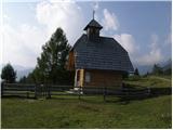 6
6 7
7 8
8 9
9 10
10 11
11 12
12 13
13 14
14 15
15 16
16 17
17 18
18 19
19 20
20 21
21 22
22 23
23 24
24 25
25 26
26 27
27 28
28 29
29 30
30 31
31 32
32 33
33 34
34 35
35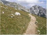 36
36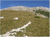 37
37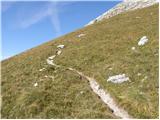 38
38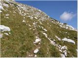 39
39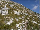 40
40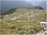 41
41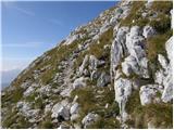 42
42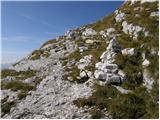 43
43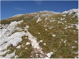 44
44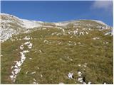 45
45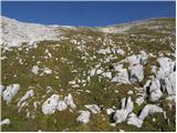 46
46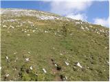 47
47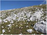 48
48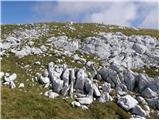 49
49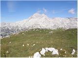 50
50 51
51 52
52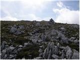 53
53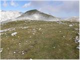 54
54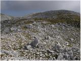 55
55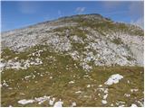 56
56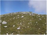 57
57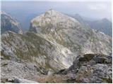 58
58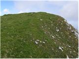 59
59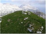 60
60
Discussion about the trip Uskovnica (Razpotje) - Tosc
|
| maateja2. 04. 2012 |
Three days ago my dear one went on this trail to Tosc (I'm recovering :tongue . The trail is generally dry, a little snow still on the serpentines below the trail around Tosc - just enough to clean and refresh the hiking boots a bit . The trail is generally dry, a little snow still on the serpentines below the trail around Tosc - just enough to clean and refresh the hiking boots a bit  . But one part of the trail from Uskovnica is damaged again. Yes, this trail is very vulnerable, already has some pegs and supports and scrapes, but at the same time it is so pleasant, beautiful, quiet and moderate. . But one part of the trail from Uskovnica is damaged again. Yes, this trail is very vulnerable, already has some pegs and supports and scrapes, but at the same time it is so pleasant, beautiful, quiet and moderate.
|
|
|
|
| katty2. 04. 2012 |
So, we'll have to climb up here soon. I think this path is quite uncrowded, and you can find silence and peace in this area. Thanks maateja for this post, it's more than welcome . .
|
|
|
|
| maateja3. 04. 2012 |
I'm glad, Katty, I think you'll like it. Then let me know if I'm right. I've added some more photos at Razmere below Tosc.
|
|
|
|
| gorskarozica22. 09. 2012 |
In wonderful weather Tosc was also a fairly visited peak. Warm autumn sunshine, no wind, wonderful view of the surrounding peaks. I recommend the tour to other hikers. 
|
|
|
|
| Laščan5. 07. 2013 |
Does anyone know how the damaged section of the path is (pictures 25 and 269). Has anything been "repaired" or is the passage safe?
Thanks!
|
|
|
|
| Laščan6. 07. 2013 |
Still relevant question. What is the condition at the "collapsed" spot (pictures 25 and 26)?
|
|
|
|
| lubadar6. 07. 2013 |
I was there last autumn and if I remember correctly it's repaired there, but the passages in pictures 18 and 27 also require a bit more caution.
|
|
|
|
| BlackDiamond30. 06. 2015 |
Is the trail anywhere exposed or dangerous for slipping? Is it harder than Komarča?
|
|
|
|
| zico1030. 06. 2015 |
The trail is much easier than to Komarča.... The trail is not dangerous for slipping....
|
|
|
|
| exwannabe18. 07. 2021 16:13:37 |
By any chance does anyone know the status of this path? On the PZS site it's marked closed, but I don't know how up-to-date they are since the path to Krstenica is also listed closed but it's perfectly passable, just a bit more demanding orientation-wise due to logging.
|
|
|
|
| jax18. 07. 2021 16:24:07 |
It's also closed on site with a sign. How it really is I didn't check, but second-hand (from fairly reliable sources) I heard that one crossing is really quite badly eroded. Now each must decide themselves if they'll try it...
|
|
|
|
| exwannabe18. 07. 2021 18:52:34 |
Thanks, then it'll be the other option.
|
|
|
|
| Samorog15. 11. 2022 16:20:08 |
On Sunday (13.11.2022) I walked the described route when descending from Tosc to Uskovnica. Although it is not marked on the PZS website that the path is closed, about two-thirds of the way down there is a quite bad landslide, marked on site with a sign saying the path is closed. It's about 50 meters where greater caution is needed, but for now it's still passable. Actually, I see no sense in such marking, because in case of impassability I would have to return to the Tosc pasture and over Studorski preval to Rudno polje, where I had my car parked. The closure marking should be at the junction itself, when one still has an alternative to decide, especially since there is no notice on the PZS website. Otherwise, really nice and uncrowded path.
|
|
|
|
| mukica16. 11. 2022 05:53:11 |
Samorog, this path has been in such a damaged condition for more than 15 years. The association that maintains the path does nothing to repair it, doesn't inform, and it's very uncomfortable for groups...
|
|
|
|
| KarmenT16. 11. 2022 18:12:30 |
If I understand correctly, the problematic part of the path is called čez Čiprije. I walked it this summer and it's completely fine. There's a bypass made on the problematic section, new cables.
|
|
|
|
| Hribolazec8116. 08. 2023 23:14:15 |
Hi, how is parking, is it paid?
Are there big crowds on weekends if I arrive at the starting point at 7 am?
Thanks
|
|
|
|
| turbo17. 08. 2023 08:34:52 |
|
|
|
|
| Hribolazec8118. 08. 2023 20:18:16 |
turbo, not everyone has time to browse, we go to work, after work still work, this could be written on this page, what is the condition of the path
I was on Tuesday at Veliki Draški vrh from Rudno polje, so I don't have to walk the same path, the end of the road at Pokluka is also closed (I have no idea why)
|
|
|
|
| Enka18. 08. 2023 21:12:36 |
At the end of the path description above it clearly states:
"Recently, parking is prohibited at the mentioned parking lot, so we have to park at Rudno polje, which extends the path by about 35 minutes, or choose the starting point Uskovnica (Lom)."
|
|
|
To post a comment you must log in:
If you do not yet have a username, you must first
register.