Uskovnica (Razpotje) - Triglav (via Planika and Mali Triglav)
Starting point: Uskovnica (Razpotje) (1215 m)
| Latitude/Longitude: | 46,32670°N 13,91070°E |
| |
Route name: via Planika and Mali Triglav
Walking time: 6 h 30 min
Difficulty: very difficult marked way
Elevation gain: 1649 m
Elevation difference along the route: 1875 m
Map: Triglav 1:25.000
Recommended equipment (summer): helmet, self belay set
Recommended equipment (winter): helmet, self belay set, ice axe, crampons
Views: 34.008
 | 3 people like this post |
Access to starting point:a) Leave the Gorenjska motorway at the Lesce exit, then follow signs for Bled and Pokljuka. Continue through Gorje and past the Zatrnik ski slope to Rudno polje on Pokljuka, where there is a large paid parking lot, nearby also a military barracks and shooting range. From here continue straight on the gravel road, which a little further brings us to a junction, where we continue left towards Uskovnica (right Planina Konjščica). From here we drive another good 500 m to the former parking lot above Uskovnica. This area is called Razpotje.
Now parking is prohibited at the mentioned parking lot, so we must park already at Rudno polje, which extends our route by approximately 35 minutes, or choose the starting point Uskovnica (Lom).
b) From Železniki or Podbrdo drive to Bohinjska Bistrica, then continue driving towards Bled. Shortly after the Petrol gas station, located just after Bohinjska Bistrica, continue left towards Pokljuka and Jereka. The road first ascends steeply, then gradually flattens after Koriti and brings us to a junction at the bus stop, where we continue right towards Pokljuka, Koprivnik and Jereka (straight Srednja vas). Immediately after the junction we arrive in Jereka, but from the junction in front of the church we continue straight towards Pokljuka (left Podjelje). After Jereka the road begins to ascend more steeply again, higher it flattens and continues along Mrzli potok. When we join the road from Bled go left and drive to Rudno polje, where there is a large paid parking lot, nearby also a military barracks and shooting range. From here continue straight on the gravel road, which a little further brings us to a junction, where we continue left towards Uskovnica (right Planina Konjščica). From here we drive another good 500 m to the former parking lot above Uskovnica. This area is called Razpotje.
Now parking is prohibited at the mentioned parking lot, so we must park already at Rudno polje, which extends our route by approximately 35 minutes, or choose the starting point Uskovnica (Lom).
Traffic regime in the Pokljuka and Uskovnica area from 15.6. to 15.10.
Route description:
From the former parking lot at the junction, continue on the forest road closed to public traffic, which begins to descend more steeply towards the gorge of the Ribnica stream. After a short descent, we reach the mentioned gorge, over which there is a wide car bridge. The road flattens after the bridge and after a few minutes of further walking brings us out of the forest onto the vast meadows of Uskovnica.
Here we walk to the nearby chapel, then continue the path slightly right on the road that runs right next to the mentioned chapel (left Koča na Uskovnici, right Planina Konjščica).
The fairly flat road leads us further across the extensive meadows of Uskovnica, then brings us to the edge of the forest, where it begins to turn into a initially still wide cart track. The cart track, which begins to ascend moderately further on, has some junctions, but we follow it towards Vodnikov dom on Velem polju and Triglav. Higher up, the cart track, which mostly runs through the forest, turns into a hiking path, which quickly brings us to a pleasant spring below Mesnova glava, called Štapce. At the spring, continue straight (right hunter's hut) and continue the ascent on a gentle path that a little further brings us to steep slopes. Already soon after arriving at the steep slopes, fixed protection aids us in crossing a steep gully. The path continues over relatively steep slopes that are especially slippery when wet. During the crossing of the steep slopes, the path ascends steeply for short periods and then descends again. In the last part of the crossing, we cross several very steep gullies, over which the path is locally completely destroyed (high risk of slipping). The crossing ends at a larger torrent (usually a spring) behind which we enter a softer grassy world.
A few minutes of easy walking follow and the path brings us to the abandoned Planina Spodnji Tosc. The path ahead begins to ascend moderately and soon brings us to a small junction, where we turn sharply right (straight old, partly abandoned path) on a well-traceable path. The path ahead begins to ascend more and more steeply and quickly brings us from the belt of sparse forest into the bushes, where it begins to turn more to the left. The path soon flattens and from the bushes brings us to grassy slopes, over which in a few minutes of further walking we climb to the Pokljuka - Triglav path, where we turn left.
The path ahead crosses the southern slopes of Tosc, then in a slight descent crosses a short belt of sparse forest, behind which we arrive at the steep slopes of Tosc. A little further, the path on an artificially made wide ledge in a slight descent crosses the precipitous slopes of the same mountain. Since the path is quite wide, it does not cause problems (but be careful due to falling rocks, rockfall in 2008). The path then ascends slightly again and brings us to a junction, where we continue right towards Vodnikov dom (sharply left Voje and Stara Fužina, slightly left Velo polje). Another approximately ten minutes of walking follow without major ascents or descents and we arrive at Vodnikov dom on Velem polju, where there is the next junction.
Here too, continue straight towards Triglav, the path begins to ascend transversely along the slopes of Vernar, higher up it also becomes technically demanding. Some crossing follows, where a fixed cable assists us, higher up we reach a steep jump, where with the help of numerous pegs and a fixed cable we climb up stone steps.
The path ahead flattens, the slope becomes less steep and near Konjsko sedlo also somewhat more grassy.
We easily descend to Konjsko sedlo, from the marked junction on the saddle we head left towards Dom Planika pod Triglavom (straight Triglavski dom na Kredarici and Dom Valentina Staniča pod Triglavom, right Krma) and begin to ascend quite steeply to the west. For some time we approach Mokra skala (2266 m), then the path turns right and passes onto an indistinct ridge, where it temporarily flattens. The marked path higher up bypasses a small cirque on the right side, then begins to turn to the left. Another approximately ten minutes of ascent follow and with nice views of the Triglav massif and surrounding mountains we arrive at Dom Planika pod Triglavom.
We bypass the mountain hut on the right side and continue towards Triglav over Mali Triglav (slightly left Triglav via Triglavska or Bovška škrbina, sharply left Koča na Doliču), where we first descend a little, then begin to ascend a gradually steeper slope. Soon we reach a rocky section, where we ascend transversely along an exposed ledge, after this section the path temporarily becomes easier. The path ahead turns right and ascends through scree to the climbing section, directed by a large marker visible from afar.
Continue the ascent along a distinct secured gully, where with the help of a fixed cable we climb to a nice vantage point, where the path turns left. A steep ascent follows over rugged rock, where on the more difficult and exposed sections frequent fixed protections mostly assist us.
Higher we reach the ridge of Mali Triglav, where we join the usually more visited path from Kredarica.
Continue straight, or slightly left (right down to Kredarica) and quickly reach the summit of Mali Triglav.
From Mali Triglav a slight descent follows along an occasionally less exposed ridge, when we start ascending again the ridge narrows, the path becomes precipitous on both sides. Further on, several quite steep ascents follow, the path is mainly well secured with cables and individual pegs, up to the summit on nice days there may be delays due to passing. Below the summit the path becomes less demanding, but still precipitous. Just below the summit, a path branches slightly left towards Staničevo zavetišče (emergency bivouac carved into the Triglav massif), we follow the still cautious but last few meters less steep path to Aljažev stolp, located on the summit of Triglav, the highest mountain of the Julian Alps and Slovenia.
Starting point - Uskovnica 0:15, Uskovnica - Štapce 0:50, Štapce - Planina Spodnji Tosc 1:15, Planina Spodnji Tosc - Planina Zgornji Tosc 0:30, Planina Zgornji Tosc - Na Zagonu 0:20, Na Zagonu - Vodnikov dom 0:20, Vodnikov dom - Konjsko sedlo 0:30, Konjsko sedlo - Planika 1:00, Planika - Mali Triglav 0:55, Mali Triglav - Triglav 0:35.

Photos:
 1
1 2
2 3
3 4
4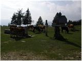 5
5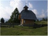 6
6 7
7 8
8 9
9 10
10 11
11 12
12 13
13 14
14 15
15 16
16 17
17 18
18 19
19 20
20 21
21 22
22 23
23 24
24 25
25 26
26 27
27 28
28 29
29 30
30 31
31 32
32 33
33 34
34 35
35 36
36 37
37 38
38 39
39 40
40 41
41 42
42 43
43 44
44 45
45 46
46 47
47 48
48 49
49 50
50 51
51 52
52 53
53 54
54 55
55 56
56 57
57 58
58 59
59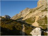 60
60 61
61 62
62 63
63 64
64 65
65 66
66 67
67 68
68 69
69 70
70 71
71 72
72 73
73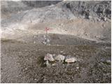 74
74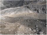 75
75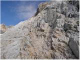 76
76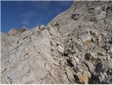 77
77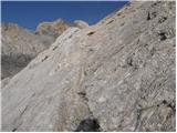 78
78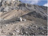 79
79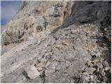 80
80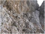 81
81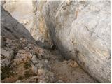 82
82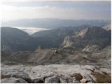 83
83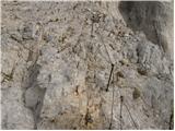 84
84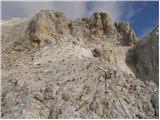 85
85 86
86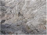 87
87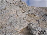 88
88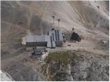 89
89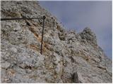 90
90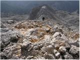 91
91 92
92 93
93 94
94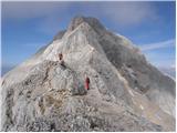 95
95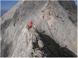 96
96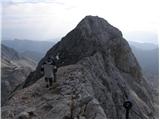 97
97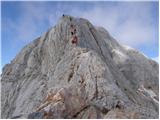 98
98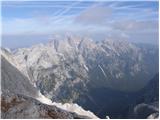 99
99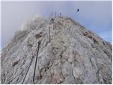 100
100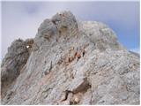 101
101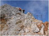 102
102 103
103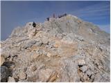 104
104 105
105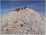 106
106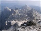 107
107 108
108
Discussion about the trip Uskovnica (Razpotje) - Triglav (via Planika and Mali Triglav)
|
| mprimo44. 12. 2006 |
I've hiked somewhere nearby before, but this will be my first route in this area, when it's possible (probably June 2007
|
|
|
|
| Triglavček199021. 10. 2009 |
Hi!
I'm wondering if anyone has any data on conditions for this path?
Perhaps someone knows how much snow there is towards the top and if the path is possibly icy?
Thank you for the reply and safe steps to everyone!
|
|
|
|
| Triglavček199021. 10. 2009 |
Hi!
I'm wondering if anyone has any data on conditions for this path?
Perhaps someone knows how much snow there is towards the top and if the path is possibly icy?
Thank you for the reply and safe steps to everyone!
|
|
|
|
| nala23. 07. 2010 |
Hi! In the second half of August we plan to go to Triglav. I'm wondering if we've chosen correctly to go by this path, given that we're not great mountaineers, but we have enough stamina. For the descent, to make it as easy as possible and not return the same way, but make a loop, we don't know. So we ask you to share your experiences and thanks for the answer and safe steps to all!
|
|
|
|
| Klin23. 07. 2010 |
The path from Uskovnica is a bit tedious at the beginning. Better go from Pokljuka or Krma.
|
|
|
|
| katjuša223. 07. 2010 |
I hiked this trail a few years ago. It didn't seem too boring to me, but maybe less frequented than the one from Pokljuka.
For the return, we went to Sedmerih jezer and via Komarča,...
The trail is probably described here on the portal.
Otherwise, my memory fails me a bit to give exact information. We hiked more for enjoyment and I think it took fully 4 days then, as we took the path to Triglav more for wandering the hills than for competition.
|
|
|
|
| nala26. 07. 2010 |
Hi! First thanks for the useful info, we'll decide more easily. Anyway, our ascent to Triglav will probably take 2 to 3 days. Our goal is to make the most of this beautiful mountain life in our mountains. lp
|
|
|
|
| ppetrov514. 08. 2011 |
Dear hikers and mountain lovers, tourists, sailors.....
Everything is OK up to the foot of Mali Triglav! CATASTROPHE And personally Triglav won't see me anymore! Disregard for right of way, crowds of masses rolling from all directions, throwing stones (rocks) at the exit just so someone gets down faster. Impatience... Not to mention improper equipment... No helmets, no self-belay gear, in sneakers, sweatpants and T-shirt... Comments like we're climbing Mount Everest with our gear etc.... At the top selling beer, T-shirts, chocolate etc.. The latter might be OK but alcohol?? Triglav has become just a trophy that most want to conquer AT ANY COST!! Sad! I really hope that the Alpine Association of Slovenia will move towards safety and not just react passively but actively organize guided accesses from all directions with a mountain guide! For unequipped groups or individuals, STRICTLY prohibit access to this beautiful mountain! Otherwise Triglav will lose its meaning... if it hasn't already! Best regards!
|
|
|
|
| IgorZlodej14. 08. 2011 |
This opinion is completely off the mark. Forbid individuals access, please, read what you wrote a few more times. Go up in January if you're capable, if not hire a guide and don't push through in the biggest crowd mid-August.
|
|
|
|
| JusAvgustin14. 08. 2011 |
I agree with Igor, this is not an opinion at all, this is primitive thinking. Who still goes to Triglav at the peak of the season?!
|
|
|
|
| ppetrov514. 08. 2011 |
Igor Zlodej, Jus Avgustin,
in that case it's the same as writing that it's primitive to go to the sea at the peak of the season and almost experience a car accident! Better go in winter because there's less traffic on the road..?
Primitive? Do you think hiking to Triglav WITHOUT a helmet and self-belaying gear is primitive? Well, unfortunately not to me! And Triglav isn't my favorite mountain..rather Mangart, Škrlatica, Dolomites etc...Where you see hikers who follow basic mountaineering rules...And precisely at the peak of the season, visitors should pay more attention to their own safety and others' than before. And I think it doesn't matter when you go up. There are some basic written rules that everyone should follow just for safety, then the date plays no role! But since I assume you'll both puff up again, both read the info about the fish blow-up doll! Basically, it's very small 
|
|
|
|
| JusAvgustin14. 08. 2011 |
and very poisonous... I still think your thinking is completely wrong: "individuals must STRICTLY be forbidden access to this beautiful mountain! Otherwise Triglav will lose its meaning...it almost doesn't have one anymore! Best regards!"
|
|
|
|
| ppetrov514. 08. 2011 |
JusAvgustin,
To your regret, before the words "individuals must STRICTLY be forbidden access to this beautiful mountain! The word is UNEQUIPPED! Sorry! Otherwise I'll write it in capitals!
Good luck in the mountains!
|
|
|
|
| JusAvgustin14. 08. 2011 |
anyway both know that Triglav in the middle of the season is a pilgrimage path, that there is no tolerance, culture, proper equipment, not to mention some people's footwear. And to "hate" Triglav because of that seems a bit silly to me, don't you think? And why bother so much with others, there are many more beautiful, harder and above all solitary mountains in the immediate vicinity... I know, the whiner version, but what if it's true, it's true...
Best, blow-up doll 2
|
|
|
|
| ppetrov514. 08. 2011 |
What is true is true
Yes, unfortunately Triglav hasn't seen me for 10 years. And a lot has changed. Anyway, in the future other peaks will see me before this one
Puffer 1
|
|
|
|
| GregorC14. 08. 2011 |
ppetrov go up in about a week and you'll see a completely different picture. I don't know what you expected on Triglav in the middle of the main season. Forbid unequipped access? Are you kidding a bit, right?  no Or will you set up a guard below and check equipment? And those posers who get top gear and carry it with them so it's visible, even though they have no idea what to do with it? Would you then introduce a mandatory test on proper use? no Or will you set up a guard below and check equipment? And those posers who get top gear and carry it with them so it's visible, even though they have no idea what to do with it? Would you then introduce a mandatory test on proper use?
|
|
|
|
| heinz14. 08. 2011 |
Interesting, but I was on Thursday similarly to the year before last (last year it was a bit different) quite pleasantly surprised by the appropriate tolerance (culture) when meeting on the ridge. Despite the crowd, people still know how to remain human. Otherwise it's like this, if you're nervous yourself, everyone gets on your nerves, or they're in your way.
Sometimes hiking alone is even safer than in pairs or groups. You definitely learn a lot more. Whoever is afraid should return to the valley for a guide (the only logical thing of course).
|
|
|
|
| ppetrov514. 08. 2011 |
GregorC,
Basically the job of mountain police is "advising mountain visitors and warning them about appropriate equipment".
You're right! Let it stay as it is
Anyway, I was thinking only of breathalyzers!
Even with that alone a lot would be done...Because in all likelihood I think I wasn't quite sober either when I pushed up..And everything I wrote was in jest!?
After all, I'm a typical Slovene who gets pissed..The others are all wise..That's how it is in this little country
Good luck in the mountains
|
|
|
|
| nivesb14. 08. 2011 |
Unfortunately it's true what ppetrov5 wrote!
Triglav is a goal for pilgrims. At the top people have fun as if they were in some shopping center.
Quote article..From Maja Ikanovič, Tomaž Marolt..
Sad picture of Triglav National Park
We conquered Triglav, but unfortunately confirmed our assumptions that this is no longer high mountains, but just a trophy that most want to conquer at any cost. People climb to the top without equipment and without knowledge, guides quietly rub their hands. I'm surprised so few accidents happen on this summit.
Triglav with its lakes has unfortunately become a tourist attraction and trophy for masses that don't belong in high mountains. For those who own it, only profit matters, so I don't doubt that in a decade a cable car will go to the top, for viewing lakes they'll charge entrance. Chamois and other wild animals will be locked in some reserve so tourists can photograph them. The road to Triglav Lakes is already there anyway, just needs asphalt and it's complete.
|
|
|
|
| jujujuhuhu21. 08. 2012 |
It is known that money rules the world and that people have an instinct for greed. Those who talk about trophies seem envious or jealous to me, because someone else besides you experienced alpinists decides to go to the mountains. And I'm not worried about you - you'll find less crowded places. But don't get me wrong - I'm strictly against exploiting nature in any way, and I also think alcohol doesn't belong in the mountains (nor elsewhere!). However, the opinion that the broader masses don't belong up there, that there's too much crowding and that people see Triglav only as a trophy - that's off the mark! Trophy or some other term - that's not in your thoughts at all, is it?! People go to nature, to the mountains, yes, and if you reach the summit - well prepared! - that's an achievement, ergo a trophy.
It is true, however, that there is too little public awareness about the nature of the path itself, the necessary preparation, safety, etc..
|
|
|
|
| Alesko197121. 08. 2012 |
What a person is in the valley, such he will be in the mountains too. Greed and caution do not begin or end at 2000m. Greed always feels the blow to the pockets the most. When GRS starts charging like the neighbors do, there will be significantly less foolishness in the hills. Insurance companies should do their part, every reasonable person will insure themselves - likewise, the state should regulate concessions, and GRS will at the same time provide paid jobs to people who like doing it. Far be it from me to be against the existing system. All honor to the enthusiasts in GRS.
|
|
|
|
| jax21. 08. 2012 |
I have to strongly agree with juhuhuhu - trophy might not be the nicest term - but isn't achievement the essential element of every hill walking? That thing we'll gladly talk about over a beer? That we reached that high mountain? That it was hard, but we managed? It's about overcoming oneself and that's one of the essential elements. Now it's clear that with Triglav there's something more at play and that's connected to some Slovenian sanctities - Triglav is just a mountain, no matter how some try to show it's more. This isn't the only case of such an overstrained attitude towards certain symbols and activities (remember the debate on the status of culture).
And on the debate about lack of culture and mountain guides: Guides do at least nominally refer to mountaineering ethics and are supposed to care for the level of culture in the mountains, but experiences of many (not first-hand) say that especially in the central Alps guides are among the most arrogant participants in the mountains. So - I don't know if that really contributes to generally raising the level of culture.
|
|
|
|
| wanyola22. 08. 2012 |
I was up there yesterday, there was a crowd, but I didn't notice any impatience or rudeness among people, everyone was friendly and polite. Of course every mountaineer wants to conquer Triglav at least once and there's nothing wrong with that. I met an incredible number of well-equipped foreigners. Once you reach the summit, it's pure pleasure. The feeling is unique and talking about some kind of trophy is completely wrong.
|
|
|
To post a comment you must log in:
If you do not yet have a username, you must first
register.