Uskovnica (Razpotje) - Vernar
Starting point: Uskovnica (Razpotje) (1215 m)
| Latitude/Longitude: | 46,32670°N 13,91070°E |
| |
Walking time: 4 h 45 min
Difficulty: very difficult pathless terrain
Elevation gain: 1010 m
Elevation difference along the route: 1215 m
Map: Triglav 1:25.000
Recommended equipment (summer): helmet
Recommended equipment (winter): helmet, ice axe, crampons
Views: 1.823
 | 2 people like this post |
Access to starting point:a) Leave the Gorenjska motorway at the Lesce exit, then follow signs for Bled and Pokljuka. Continue through Gorje and past the Zatrnik ski slope to Rudno polje on Pokljuka, where there is a large paid parking lot, nearby also a military barracks and shooting range. From here continue straight on the gravel road, which a little further brings us to a junction, where we continue left towards Uskovnica (right Planina Konjščica). From here drive another good 500 m to the former parking lot above Uskovnica. This area is called Razpotje.
Now parking is prohibited at the mentioned parking lot, so we must park already at Rudno polje, which extends the route by approximately 35 minutes, or choose the starting point Uskovnica (Lom).
b) From Železniki or Podbrdo drive to Bohinjska Bistrica, then continue driving towards Bled. Shortly after the Petrol gas station, located just a little after Bohinjska Bistrica, continue left towards Pokljuka and Jereka. The road first ascends steeply, then gradually flattens after Koriti and brings us to a junction at the bus stop, where we continue right towards Pokljuka, Koprivnik and Jereka (straight Srednja vas). Immediately after the junction we arrive in Jereka; from the junction in front of the church, we continue straight towards Pokljuka (left Podjelje). After Jereka the road begins to ascend more steeply again, higher it flattens and continues along the Mrzli potok stream. When we join the road from Bled go left and drive to Rudno polje, where there is a large paid parking lot, nearby also a military barracks and shooting range. From here continue straight on the gravel road, which a little further brings us to a junction, where we continue left towards Uskovnica (right Planina Konjščica). From here drive another good 500 m to the former parking lot above Uskovnica. This area is called Razpotje.
Now parking is prohibited at the mentioned parking lot, so we must park already at Rudno polje, which extends the route by approximately 35 minutes, or choose the starting point Uskovnica (Lom).
Traffic regime in the Pokljuka and Uskovnica area from 15.6. to 15.10.
Route description:
From the former parking lot at the junction, continue along the forest road closed to public traffic, which begins to descend more steeply towards the gorge of the Ribnica stream. After a short descent, we reach the mentioned gorge, over which a wide car bridge leads. The road flattens after the bridge and after a few minutes of further walking brings us out of the forest onto the vast meadows of Uskovnica.
Here we walk to the nearby chapel, then continue slightly right along the road that runs right next to the mentioned chapel (left Koča na Uskovnici, right Planina Konjščica).
The fairly flat road leads us further across the extensive meadows of Uskovnica, then brings us to the edge of the forest, where it begins to turn into an initially still wide cart track. The cart track, which further begins to ascend moderately, has a few junctions, but we follow it towards Vodnikov dom on Velem polju and Triglav. Higher up, the cart track, which for the most part runs through the forest, turns into a hiking path, which quickly brings us to a pleasant spring below Mesnova glava, called Štapce. At the spring, continue straight (right hunter's hut) and continue the ascent along a gentle path, which a little further brings us to steep slopes. Already soon after arriving at the steep slopes, safety gear assists us in crossing the steep gully. The path continues along relatively steep slopes that are especially slippery when wet. During the crossing of the steep slopes, the path ascends steeply for short periods and then descends again. In the last part of the crossing, we cross several very steep gullies, over which the path is locally completely destroyed (high risk of slipping). The crossing ends at a larger torrent (usually a spring) behind which we enter a softer grassy world.
A few minutes of easy walking follow, and the path brings us to the abandoned Planina Spodnji Tosc. The path further begins to ascend moderately and soon brings us to a small junction, where we continue sharply right (straight old, partially abandoned path) along a well-marked path. The path further begins to ascend more steeply and quickly brings us from the belt of sparse forest into the bushes, where it begins to turn more to the left. The path soon flattens and brings us from the bushes onto grassy slopes, over which in a few minutes of further walking we ascend to the Pokljuka - Triglav path, where we turn left.
The path further crosses the southern slopes of Tosc, then in a slight descent crosses a short belt of sparse forest, behind which we arrive at the steep slopes of Tosc. A little further, the path along an artificially made wide ledge in a slight descent crosses the precipitous slopes of the same mountain. Since the path is quite wide, it does not cause problems (but caution due to falling rocks, rockfall in 2008). The path then ascends slightly again and brings us to a junction, where we continue right towards Vodnikov dom (sharply left Voje and Stara Fužina, slightly left Velo polje). Another approximately ten minutes of walking follow without major ascents or descents, and we arrive at Vodnikov dom na Velem polju.
At Vodnikov dom, head right towards Bohinjska vratca and Krma (straight Triglav), where we first ascend past the botanical garden, then begin to ascend steeply along steep, mostly grassy slopes between Vernar on the left and Tosc on the right. Higher up, we reach an indistinct valley, along which in a few minutes we ascend to Bohinjska vratca, from where a beautiful view opens towards Krma.
From Bohinjska vratca, continue left onto an unmarked path that leads up along the grassy slope. The grassy slope becomes steeper and steeper and is particularly very dangerous for slipping when wet. We follow the steep path, which runs slightly left of the ridge, all the way to the grassy forepeak at 2183 m.
From the forepeak, continue along the ridge and first descend steeply a few meters along the rocky slope. Continue along the ridge, which becomes quite narrow and exposed. We walk mostly on the left side of the ridge, the direction is also indicated by some cairns. A few very short climbing sections (I-II grade) follow, and we are already at the top of Vernar.
Starting point - Uskovnica 0:15, Uskovnica - Štapce 0:50, Štapce - Planina Spodnji Tosc 1:15, Planina Spodnji Tosc - Planina Zgornji Tosc 0:30, Planina Zgornji Tosc - Na Zagonu 0:20, Na Zagonu - Vodnikov dom 0:20, Vodnikov dom - Bohinjska vratca 0:25, Bohinjska vratca - Vernar 0:50.

Along the route: Kapela Kraljice miru na Uskovnici (1177m), Izvir Štapce (1452m), Planina Spodnji Tosc (1663m), Planina Zgornji Tosc (1849m), Na Zagonu (1819m),
Vodnikov dom (1817m), Bohinjska vratca (1975m)
Photos:
 1
1 2
2 3
3 4
4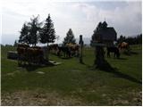 5
5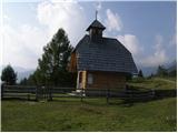 6
6 7
7 8
8 9
9 10
10 11
11 12
12 13
13 14
14 15
15 16
16 17
17 18
18 19
19 20
20 21
21 22
22 23
23 24
24 25
25 26
26 27
27 28
28 29
29 30
30 31
31 32
32 33
33 34
34 35
35 36
36 37
37 38
38 39
39 40
40 41
41 42
42 43
43 44
44 45
45 46
46 47
47 48
48 49
49 50
50 51
51 52
52 53
53 54
54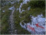 55
55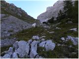 56
56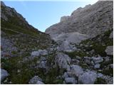 57
57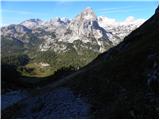 58
58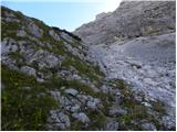 59
59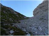 60
60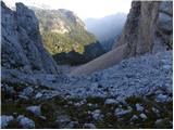 61
61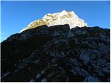 62
62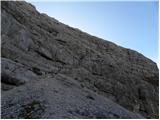 63
63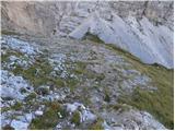 64
64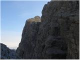 65
65 66
66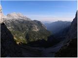 67
67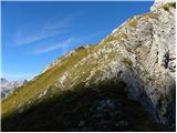 68
68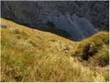 69
69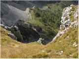 70
70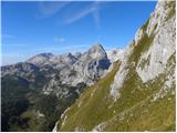 71
71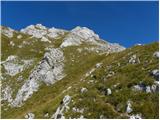 72
72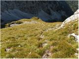 73
73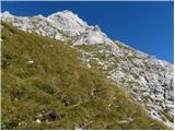 74
74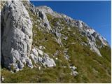 75
75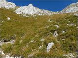 76
76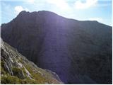 77
77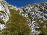 78
78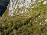 79
79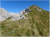 80
80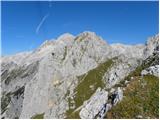 81
81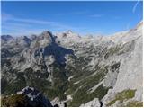 82
82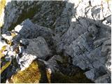 83
83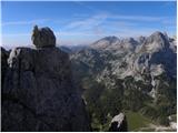 84
84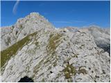 85
85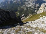 86
86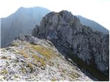 87
87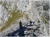 88
88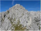 89
89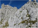 90
90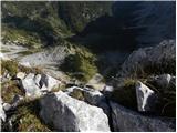 91
91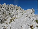 92
92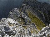 93
93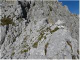 94
94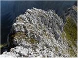 95
95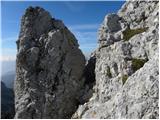 96
96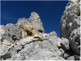 97
97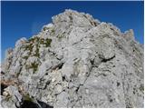 98
98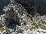 99
99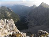 100
100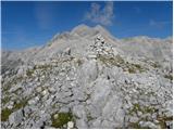 101
101
Discussion about the trip Uskovnica (Razpotje) - Vernar
To post a comment you must log in:
If you do not yet have a username, you must first
register.