V Koncu - Bivak pod Skuto (via Žmavčarje)
Starting point: V Koncu (900 m)
| Latitude/Longitude: | 46,34200°N 14,56820°E |
| |
Route name: via Žmavčarje
Walking time: 3 h
Difficulty: difficult unmarked way
Elevation gain: 1170 m
Elevation difference along the route: 1170 m
Map: Kamniške in Savinjske Alpe 1:50.000
Recommended equipment (summer):
Recommended equipment (winter): ice axe, crampons
Views: 74.753
 | 4 people like this post |
Access to starting point:
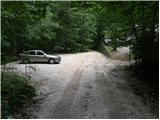
We drive to Kamnik and follow the road ahead towards the valley of Kamniška Bistrica. From the hut in Kamniška Bistrica we continue driving on the forest road, which brings us higher to a crossroad, where we continue straight (right Jermanca, starting point for Kamniško sedlo). The road then past Žagana peč brings us to the parking lot at the lower station of the cargo cableway to Kokrsko sedlo.
Driving from the mountain hut in Kamniška Bistrica to the parking lot V Koncu is now forbidden (traffic sign), this extends the path by less than an hour.
Route description:
From the parking lot at the cargo cableway we continue on an increasingly rough road which after 10 minutes of walking changes into a cart track. The cart track splits into two parts, and we head for the right one (the left cart track vanishes, or leads towards Gamsov skret), which at a smaller boulder covered with moss (big rock) turns even a bit more to the right. Right at this spot we leave the cart track and continue straight onto an initially poorly visible footpath, which later steeply ascends in zigzags. A steep and especially when wet dangerous for slipping path leads us across steep slopes, which at some spots are secured with a steel cable. The steep path, which also crosses a few gullies, then brings us higher to less steep slopes. After a good hour of walking the path brings us out of the forest, where it starts to ascend steeply again. The path first leads across grassy slopes surrounded by sparse forest, then with the aid of some fixed safety gear brings us one level higher. The path further transitions to gravelly slopes, which somewhat hinder the ascent, then the path turns left onto steep grassy slopes rising above extensive scree fields. At the top of this grassy section we head slightly right and the path transitions from grass to high-alpine terrain of the basins under Skuta. Further along the path lined with cairns we reach the pleasant bivouac under Skuta in a few minutes.

Photos:
 1
1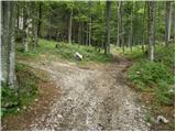 2
2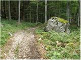 3
3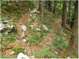 4
4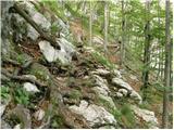 5
5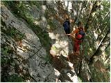 6
6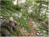 7
7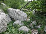 8
8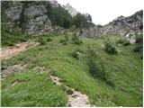 9
9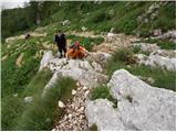 10
10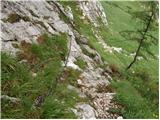 11
11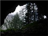 12
12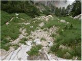 13
13 14
14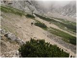 15
15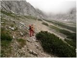 16
16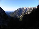 17
17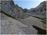 18
18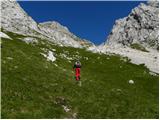 19
19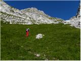 20
20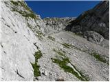 21
21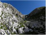 22
22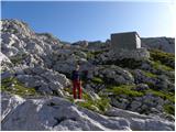 23
23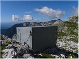 24
24
Discussion about the trip V Koncu - Bivak pod Skuto (via Žmavčarje)
|
| Barpka113. 11. 2015 |
Yesterday for the first time on this path, pleasant and nicely traceable, more strenuous downhill than uphill. It would be nice if the administrator of this website would update the old path descriptions (including photos) as soon as possible, including this one. The path is actually marked with somewhat faded red dots (so it's not unmarked as stated), the start at the boulder is also somewhat awkwardly described. As already written in the comments at Turska gora, the path length is tailored to very fast hikers. In the printed guide Kamniško-Savinjske Alpe, a much more realistic time is given for the average "Sunday" hiker without excellent fitness: 3-3.30 h. On short days, this can be quite important information.
I hope that at least next year they will remove the old yoga mats that were dumped into the cave near the bivouac, and also the door of the new bivouac sometimes doesn't close well, so please close it properly behind you so that no one following is unpleasantly surprised.
|
|
|
|
| grega_z_brega13. 11. 2015 |
It's true as Barbka writes, you have to step quite well to reach the bivouac in 2 hours and 45 min, because steepness accompanies you the whole way.
At the crossing in picture 7, the cable is torn.
Those yoga mats... surprise 
|
|
|
|
| Meto13. 11. 2015 |
The trail via Žmavčarje is unmarked and the wild markings don't change that.
|
|
|
|
| marko hribinet23. 11. 2015 |
Hello. I would like to inquire about the difficulty of this tour in winter conditions. I have been hiking in the mountains for some time (e.g. Brana, Planjava, Velika baba via climbing route, Hanzova on Mojstrovka, via ferrata on Češko kočo etc.), but in winter conditions I only have experience with mid-mountains (Ratitovec, Porezen, Kamniško sedlo and similar). Therefore, I would like to find out how demanding this tour is in winter or if it is dangerous. These days I plan to buy some proper crampons. Thank you in advance for the information!
|
|
|
|
| marko hribinet24. 11. 2015 |
Can I ask here for some suggestion for an easier and safe winter ascent in Kamnik Alps (but not Kamniško or Kokrško sedlo, Kamniški vrh, Kamniški dedec or Velika planina). Thanks!
|
|
|
|
| zokica24. 11. 2015 |
Raduha from Loka
Dleskovška planota, or Lučki Dedec from Pl. Podvežak.
On the mentioned path over Žmavčarje there is great exposure to avalanches in winter.
|
|
|
|
| marko hribinet24. 11. 2015 |
Thanks, Zokica. Maybe also Konj and Rzenik?
|
|
|
|
| Barentoter24. 11. 2015 |
A few winter ascents in KSA from easier to harder (my ratings): Raduha from Loka, Storžič from Mač over Kališće, Brana (in winter different approach than summer) from Kamniška Bistrica, Grintavec over Streha (dangerous due to slipping).
|
|
|
|
| subaru24. 11. 2015 |
Of the above suggested winter tours for a beginner like marko hribinet, neither Storžič (on the mentioned path) nor especially Brana, which can be quite treacherous, are suitable by any means.
|
|
|
|
| martin424. 11. 2015 |
Hello,
Brana and Grintovec have claimed the most victims in winter conditions in the past! Over Žmavčarje towards the bivouac is avalanche-prone. Everything depends on conditions, experience, equipment....etc.
best regards
m4
|
|
|
|
| smatjaz24. 11. 2015 |
Marko, from your written text I conclude that you are still a beginner in winter ascending, so if you set off into the high mountains in winter with this knowledge, the point is no longer if something happens to you, but only when it will happen (depending on how much the one up there likes you...). I myself have quite some "summer mileage" behind me but in winter I stick to lower areas more. I sincerely hope you will heed my advice, because there are quite a few self-taught people on this forum who whirl around the high mountains in winter and delight us with photos, and you too are born under such a lucky star as them...... In short, my advice is that before you take the first step in this direction, enroll in a basic course for safe walking in winter conditions and later an advanced one (several clubs organize them). Then find an experienced guide who will first advise you on equipment purchase (crampons alone are not enough.... ice axe and avalanche transceiver set are highly recommended too), and then lead you into the world of winter high mountains where completely different rules apply than in summer.
And safe steps I wish you....
|
|
|
|
| marko hribinet25. 11. 2015 |
Thanks everyone for the good advice. You too, happy trails!
|
|
|
|
| tol28. 11. 2015 |
OK, if we're honest, the objective danger in winter really increases, but that doesn't mean we have to sit at home.
If you're scared, and you see avalanche danger, slip,... on every slope, yeah then there's no point in struggling and climbing hills.
You need to be cautious enough to realistically assess when you'll tackle a slope and when you'll turn back. You'll only learn that with experience, which means go to some course, there you'll get the basics and maybe some company. Mountaineering clubs organize various winter hikes, ideal for gaining experience.
Grintavec isn't that demanding, but it has claimed quite a few victims, some due to lack of equipment. Brana is a different story. Even in super conditions, it's super dangerous.
For a start, choose a tour to Kamniško sedlo, then Kokrško sedlo.
|
|
|
|
| panda28. 11. 2015 |
Kokrško sedlo under Jurjevcem: dangerous.
|
|
|
|
| tinky28. 11. 2015 |
KokrSko
|
|
|
|
| panda29. 11. 2015 |
Yes, tinky you're right: Kokrsko sedlo.
|
|
|
|
| nickolas1626. 05. 2016 |
Has anyone been on this path to the bivouac in the last few days? Do you think the path would be snow-free by next weekend with this weather?
|
|
|
|
| anak12. 06. 2016 |
The answer is probably too late for nickolas16. We were up there yesterday in very humid and foggy weather. The last part of the path is still under snow that cannot be avoided. Yesterday crampons were not necessary.
|
|
|
|
| kotnk12. 06. 2016 |
Is there still a lot of snow? Actually I'm more interested in the circular route... Gamsov skret up... Žmavčarje down?
|
|
|
|
| bumbam22. 09. 2016 |
This week I was in the bivouac for the first time and must praise the construction. Very well insulated and decently equipped, although it pales in comparison to the bivouac under Grintovec. They could at least replace the worn-out mats. And PLEASE take your trash with you, some people fail to do so
Given that the caretaker of the PD Matica hut also maintains markings in SLO (as far as I know), I don't understand why the path through Žmavčarje is not marked. Even though markings are often followed for the next 50m from the bivouac towards Skuta or Sleme.
|
|
|
|
| dprapr22. 09. 2016 |
Some of you are really obsessed with this "painting" on the hills.
|
|
|
|
| poba6. 06. 2017 |
Does anyone perhaps have a GPS track of the path or how visible are the "wild markings"?
|
|
|
|
| poba6. 06. 2017 |
ups *who 
|
|
|
|
| rozka7. 06. 2017 |
"was" on Sunday, and once you're on it the path is so visible you can't "miss"...
|
|
|
|
| trdi24. 08. 2017 |
I would like to warn that before the mentioned boulder there is another larger boulder, where there is also a branch-off that leads through loose scree to some walls, so that no one gets confused like I did and had to go back and then found the right path.
|
|
|
|
| poba27. 05. 2018 |
A year has passed. What are the conditions like?
|
|
|
|
| Seša17. 07. 2018 |
Hi. I'm interested if the bivouac under Skuta is accessible also from the Jezersko direction?
Soon planning to do the tour Koča na Ledinah - Koroška Rinka - bivouac under Skuta. Next day Skuta - Grintovec - Kočna - Češka koča.
|
|
|
|
| MiAn17. 07. 2018 |
From Križ you descend and continue on the marked path Kamniško - Kokrsko sedlo towards the latter. After about 15 minutes, watch left for cairns that lead you to the bivouac.
|
|
|
|
| Sujcic22. 07. 2018 |
I'm wondering if the new bivouac also has some mat and blanket?
|
|
|
|
| Grenaleva23. 07. 2018 |
In the bivouac there are about 4 cm of cushions, but no blanket
|
|
|
|
| MatejaT12. 08. 2018 |
Greeting... we're interested in how the road to the parking lot in V Koncu is... still driving prohibited?
|
|
|
|
| pohodnik3812. 08. 2018 |
As far as I noticed these days while wandering around these parts, there is no sign visible for driving prohibition. But there are some potholes on the road lower down right after Kamniška Bistrica so one needs to be skilled at driving. Higher up the road is okay
Lp! Tone
|
|
|
|
| NikRoman23. 05. 2019 |
Hello! Give advice, my friend and I want to try this route. Is it possible for two tourists without experience? We want to go this summer, in the middle of June, we will be with very light backpacks.
|
|
|
|
| zokipoki24. 05. 2019 |
Hi Nik. I think if you read the description for this route well and use some maps, you shouldn't have any problems, it's an easy route to follow, very nice one, but if you don't have any experience, you should find yourself a human guide who knows this route! Take care!
|
|
|
|
| coffee24. 05. 2019 |
Keep in mind that this is unmarked route. But as Zoran implied if you have some sense for orientation and map reading it shouldn't be a problem.
|
|
|
|
| zokipoki24. 05. 2019 |
Nik, if your experience is a sunday hike type, you should take this route seriously and consider your capabilities. It's a steep, unmarked route which can take a lot of energy if one is not used to such.
|
|
|
|
| pravilisjak21. 03. 2021 |
Hello,
this morning the conditions in Žmavčarji were treacherous. It looked all fine, but still the two hikers ahead of us got caught in a slab avalanche that tumbled them approx. 50 m down the slope. Everything ended fortunately, but after this warning we of course did not continue the path to the bivouac.
|
|
|
|
| rjene1. 05. 2022 17:45:59 |
Was at the bivouac on 28.4.2022. From 1750m onwards snow. Crampons and ice axe needed. Snow was compact in the morning, wet in the afternoon. Not much, about half a meter. Anyone with more experience who knows the steepest section directly below the bivouac: Can an avalanche release on such a slope in case of afternoon wet snow, or is the danger only with dry and unprocessed snow?
|
|
|
|
| lijaneja1. 05. 2022 21:04:44 |
Since the ground is grassy, this option exists too, but at much higher temperatures than these days.
|
|
|
|
| rjene1. 11. 2022 08:20:13 |
I would warn that this bivouac fills up quickly due to all the attention it gets. On 30.10.2022 there were about 30 people at the bivouac. And many more turned back. Half of them slept outside. Conditions were pleasant, about 8 degrees at night. But still, anticipate that this can happen. In summer, Czechs swarm anyway.
|
|
|
|
| capraibex1. 11. 2022 14:32:53 |
Bivouacs no longer serve their purpose, that is, shelter in emergency.
|
|
|
|
| cen10. 09. 2024 14:34:57 |
How come at least those 15 minutes of trail from the bivouac to Malih podov are not marked? Suppose bad weather catches you while crossing to Kamniško sedlo or vice versa, where will an ordinary hiker find the junction to the bivouac? If you don't have a GPS or know exactly where the trail joins, you won't find it. The bivouac seems obviously for itself, hard to understand.
|
|
|
|
| jprim10. 09. 2024 20:09:29 |
If bad weather catches you ...
Weather forecasts, other available data, I think you already know before the hike if there will be bad weather ...
Regards!
|
|
|
|
| aladin11. 09. 2024 09:14:11 |
Enough fog or rather that the cloud base drops low enough. Nothing unusual if the cloud base fluctuates by 200 or 300 meters - depending also on local wind, which can change direction several times during the day.
|
|
|
|
| turbo11. 09. 2024 09:33:34 |
When there is no weather disturbance at least 200km from Slovenia, I rely on the domestic forecast. Otherwise, not at all. Already in the city, work, not even approximately, let alone leisure activities.
The direction towards the bivouac could really be marked, as it is primarily intended for shelter in bad weather. Perhaps a red light on solar cells could be installed on the roof so that the bivouac location is visible at night and one doesn't sleep behind a rock twenty meters away.
|
|
|
|
| garmont1. 11. 2024 14:12:37 |
After this year's flood, nothing remains of the bushes in photos 2 and 3. There is now a gravel gully 20 meters wide.
For access to the trail over Žmavčarje, you need to stick to the left side of the gully, some large cairns help.
|
|
|
To post a comment you must log in:
If you do not yet have a username, you must first
register.