V Koncu - Cojzova koča na Kokrskem sedlu
Starting point: V Koncu (900 m)
| Latitude/Longitude: | 46,34200°N 14,56820°E |
| |
Walking time: 2 h 15 min
Difficulty: easy marked way
Elevation gain: 893 m
Elevation difference along the route: 893 m
Map: Kamniške in Savinjske Alpe 1:50.000
Recommended equipment (summer):
Recommended equipment (winter): ice axe, crampons
Views: 195.549
 | 6 people like this post |
Access to starting point:
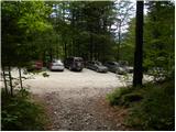
We drive to Kamnik and follow the road ahead towards the valley of Kamniška Bistrica. From the hut in Kamniška Bistrica we continue driving on the forest road, which brings us higher up to a crossroads, where we continue straight (right Jermanca, starting point for Kamniško sedlo). The road then brings us past Žagana peč to the parking lot at the lower station of the cargo cableway to Kokrsko sedlo.
Driving from the mountain hut in Kamniška Bistrica to the parking lot V Koncu is now forbidden (traffic sign), which extends the path by less than an hour.
Route description:
From the parking lot at the cargo cableway we head onto the initially gentle footpath in the direction of Kokrsko sedlo. The path first crosses a belt of shrubs, then enters a dense forest, where it starts to ascend more steeply. Higher up the forest becomes somewhat thinner, so some views open onto the surrounding peaks. The path, which continues steeply ascending, brings us higher to two successive steel cables (in dry completely undemanding), after which we reach a pleasant rest area with a bench.
The path continues back into the dense forest, then begins turning to the right, where the steepness eases for a short while. A little further the path leaves the forest, crosses an indistinct gully, and brings us to the scree slopes below Kokrsko sedlo. Here the path turns slightly left and begins steeply ascending a mostly rocky slope. A quite strenuous path (due to the scree), running below the walls of Kalška gora on the left and the less known Mali vrh on the right, finally brings us to Cojzova koča na Kokrskem sedlu amid ever finer views.

The trip can be extended to the following destinations: Kamniška koča na Kamniškem sedlu,
Kalška gora (1 h),
Bivak pod Grintovcem (1 h 15 min),
Kalški greben (1 h 45 min),
Turska gora,
Štruca (2 h 55 min),
Dolgi hrbet (2 h 45 min),
Kokrska Kočna (3 h 15 min),
Skuta (3 h 15 min),
Jezerska Kočna,
Grintovec
Photos:
 1
1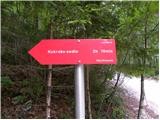 2
2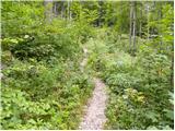 3
3 4
4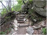 5
5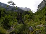 6
6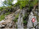 7
7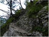 8
8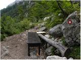 9
9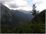 10
10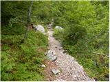 11
11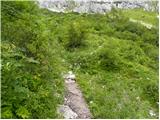 12
12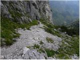 13
13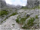 14
14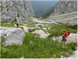 15
15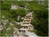 16
16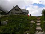 17
17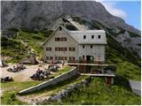 18
18
Discussion about the trip V Koncu - Cojzova koča na Kokrskem sedlu
Show older messages
|
| Gost29. 09. 2006 |
The road to the cableway is in very poor condition (not maintained); safety gear on the path needs repair (not very safe anymore, as they are no longer properly attached).
Otherwise, a very pleasant tour.
|
|
|
|
| miha dobnikar17. 02. 2007 |
17.02.2007
WINTER ASCENT
THERE WAS QUITE A LOT OF SNOW THE WINTER ROOM IS NOT OPEN ALTHOUGH IT SAYS IT IS OPEN.
CHANGE THE OWNER
IF YOU GO TO GRINTOVEC IT WOULD BE NICE.
B.R.
MIHA
|
|
|
|
| sebanakis22. 06. 2008 |
Today I hiked the mentioned trail with my girlfriend. Hot but still nice. The lady needs to learn faster service and a bit of cooking, then everything will be perfect 
Best regards
|
|
|
|
| velkavrh4. 08. 2008 |
Today was here on the way to Grintovec. For the path I would rate it easy, but it is demanding. You climb the whole way. If you lack fitness, you are simply exhausted at the top. For Sunday hikers, I think the path from Kokra from Suhadolnik on the usual route is more suitable - not to Paško.
|
|
|
|
| erko6. 10. 2008 |
I'd like to ask if the path to Grintavec is suitable for an 11-year-old child. I'd like to go there with my son on 27.10.. Do you think the conditions are good for ascent.
|
|
|
|
| erko6. 10. 2008 |
Correction: do you think the conditions are good for ascent.
|
|
|
|
| Primož766. 10. 2008 |
Until October 27th it's still far away. In the meantime, conditions can change drastically.
|
|
|
|
| robinzon7. 10. 2008 |
Today the conditions were excellent, with a bit of luck even without wind, excellently used day
|
|
|
|
| matjazD7. 10. 2008 |
I agree with the above comment! We went from Suhadolnik, via Cojzova hut to Grintavec, up in 2.5 hours, whole tour under 5 hours... nice weather, no wind, great views... excellent! Best, M 
|
|
|
|
| Skuta17. 07. 2009 |
Does anyone know if the road to the cargo cable car is OK or is it better to start directly from Kamniška Bistrica, my car isn't exactly "mountainous" 
|
|
|
|
| pikec117. 07. 2009 |
hi was there yesterday and you can get there without problems, go for it
|
|
|
|
| BojanGams25. 08. 2009 |
The road is quite fine, just go slowly and those "waves" aren't felt at all, maybe some potholes that shook me properly when I was on the bike, wow. Yesterday we took the path quickly and then continued to Grintavec, very nice path. The most strenuous is getting to Cojzova koča at all, then everything calms down and to Grintavec there's no problem at all. On the way met some young children, good that they also go up.
|
|
|
|
| Brrrranka13. 11. 2009 |
And does anyone know how the avalanche danger is these days?
|
|
|
|
| viharnik13. 11. 2009 |
No need to fear avalanches on rocky terrain. Especially now, when temperatures will be much higher, grassy slopes still need to be avoided (especially Karavanke, south side sp. Boh. gora etc.)
|
|
|
|
| viharnik13. 11. 2009 |
On the Karavanke-Stuška tour, I'm also adding a triggered avalanche.
|
|
|
|
| vojak2629. 11. 2009 |
Really nice hike, even now with snow, 100 m before the top you have to go carefully because of the snow so you don't slip. I recommend, even at this time, good footwear... LP
|
|
|
|
| Janez Kastrevc11. 04. 2011 |
Yesterday I went up this trail! I barely made it to the parking lot, as the gravel road is quite damaged!!! We didn't reach the summit because there was quite a lot of snow, I didn't expect these conditions, otherwise I would have at least taken gaiters and poles!!! Suunto showed we went up to 1635m!!! Otherwise, the hut was closed as hikers told me!!! Otherwise, snow patches start around 1400m!!! Weather was nice, every now and then there were some gusts of wind!
|
|
|
|
| andrejp11. 04. 2011 |
I was on Grintavec on Saturday and my opinion is, given how the road to the cargo cableway already was, that it is in solid condition. Otherwise nice tour, somewhere it sank in a bit more, and we also put on crampons for better feel. But there is still quite some snow. When the huts open is all on the website of the Alpine Association of Slovenia.
lpa in j
|
|
|
|
| Krak23. 05. 2011 |
Does anyone have information about the path conditions? Is there still snow?
|
|
|
|
| grinhorn23. 05. 2011 |
This is how it looked on Saturday:
|
|
|
|
| Jany23. 05. 2011 |
This space is intended for comments about trips.
Description of current conditions and pictures should be added to "Current conditions". No hard feelings.
|
|
|
|
| Krak23. 05. 2011 |
Thanks grinhorn,
You too! I didn't notice!
best regards!
|
|
|
|
| Draxi15. 10. 2011 |
I'm curious about the snow on the path, is the path passable without crampons and ice axe?
|
|
|
|
| pikec115. 10. 2011 |
Yes take them with you, or are they too heavy to take? You ask so much, of course it's winter up there and there's no need to think here. If you carry them up for nothing, at least you get extra weight training
Lp
|
|
|
|
| Gurenski pohodnk20. 03. 2012 |
Has anyone maybe been up there in March?
What are the conditions like, can one reach Cojzova koča normally and safely?
|
|
|
|
| marjanah31. 03. 2012 |
Pleasant trail. It ascends steeply all the way though. In summer I gather strength and extend it to Grintovec.
|
|
|
|
| Dominic1. 04. 2012 |
You can reach Cojzova without problems, towards the top some patches of snow or two that make walking a bit harder but you just need to put in a bit more effort on the snow because the steps are quite high... and carefully. Otherwise it's dry, just some scree on the path is annoying..
LP
|
|
|
|
| Lisica27. 05. 2012 |
Today I walked this path. The path climbs all the way, quite steep and very boring tour. But at the top disappointment - the hut was closed.
|
|
|
|
| _sandra_27. 05. 2012 |
@Lisica: most huts open mid-June.. the tour is long only as much as you make it, I went up here in five hours and on to Grintovec, and it wasn't long at all
|
|
|
|
| danicak4. 07. 2012 |
Read the trail description and all comments.... please for info if there's any particularly exposed section (desc - wire ropes) ...narrow ledge or precipitous part. At the end of the week we're planning this trail, but I admit before exposed sections I really have some "respect".....and fear.
Thanks
|
|
|
|
| jax4. 07. 2012 |
No. Some wire somewhere in the lower part as far as I remember yes there is, but really no exposure, no danger, no difficulty. But steep, strenuous, hot, unpleasant.
|
|
|
|
| pohodnik384. 07. 2012 |
On this trail since last year no more wire, the trail routed a bit differently in one part even steps, trail not at all exposed to Kokrsko sedlo but needs fitness. Further to Grintovec also nothing exposed.
|
|
|
|
| danicak4. 07. 2012 |
yes, super, the main problems for me are those exposed and precipitous sections, I have fitness, and I handle steepness quite well too.
Thanks and I'll report............
|
|
|
|
| Ajda_Zitnik8. 07. 2012 |
I walked the path last weekend (2.7.), it's in good condition, as is the road to the starting point.
As for the fixed cables on the path, they are very useful in my opinion in wet weather, in dry almost unnecessary.
Regarding exposure, some have trouble on steeper overgrown paths, even though they are wide and not exposed at all.
If that's the case, then in my humble opinion better not go up, but if problems are certain crossings, ledges, then I think there shouldn't be issues, as there are none here. The path is really steep and relentless.
|
|
|
|
| marinka6729. 07. 2012 |
Can you really no longer drive to Konca by car? I'm asking for the sake of children for whom 3 hours is already a lot.
|
|
|
|
| helsinki18. 08. 2012 |
probably they don't want guests
|
|
|
|
| Grenaleva10. 09. 2012 |
We drove to the end yesterday by car without issues, plenty of parking available too. The path personally wasn't interesting to me, as most of the steep part is in the forest, and when you finally exit the forest, the steepness increases even more. After walking in scree, a mountain goat kicked a rock that shattered 2 m under our feet, so we were really lucky. We managed the path with 10- and 11-year-old kids in two and a half hours. Some adults took the same time, so the 2h15 sign is really for those who don't need much rest on steep terrain. The hut keeper said we were still fast, they take 3 hours, because if you rush too much, it can be problematic. The descent path is even more tricky.
|
|
|
|
| trdi10. 09. 2012 |
I agree, the walking time should be adjusted to 2:45 or at least 2:30, because the gradient is considerable and you need to walk slowly.
|
|
|
|
| ljubitelj gora10. 09. 2012 |
I took 1:20 yesterday to the saddle, started at 6:30. Descent 1 hour. Usually 300 elevation gain per hour is calculated, but above it says less than 400/hour.
|
|
|
|
| ljubitelj gora10. 09. 2012 |
@Grenaleva: I had a helmet under the wall and last year it surprised me there too, 10 meters in front of me.
|
|
|
|
| tol10. 09. 2012 |
I think the standard time is set quite well.
Some are slower some faster....
I think the average hiker easily has a minute or so left....
It will never be right for everyone.
|
|
|
|
| Grenaleva13. 09. 2012 |
We are not in poor condition, since 14 days before we conquered Ojstrica exactly in the time according to the signs. True, on Sunday we weren't best disposed for hiking, so maybe we could have reached the goal 15 minutes earlier, but usually the times are for average hikers.
Personally I also assess that this path is not even remotely easy. True, it has no pegs and cables, but it's continuously steep, so you hardly rest your legs on short flats in between.
It's right to exchange opinions so others can be prepared.
|
|
|
|
| Jure8713. 09. 2012 |
The path from Suhadolnik to Kokrsko sedlo is much nicer, but time-wise comparable to the path from Konca.
|
|
|
|
| Grenaleva14. 09. 2012 |
We plan to try it when the snow melts, and then to the summit.
|
|
|
|
| laik26. 05. 2013 |
hello...I'm a total beginner, so I'm wondering if this trail is suitable for me...or is something easier better... THANKS and best regards to everyone
|
|
|
|
| jax26. 05. 2013 |
The trail is steep, strenuous and personally quite unpleasant for me, but technically it causes no problems. So if you're reasonably fit, it will be fine. Of course, wait a bit, because in this mixed weather it's currently still quite snowy. But it will soon be snow-free...
|
|
|
|
| laik26. 05. 2013 |
many thanks and best regards
|
|
|
|
| balon5. 07. 2013 |
Hello!
Is it still true that the road for public traffic in V Koncu is closed and the path is therefore 1 hour longer?
Thanks for the reply,
Balonček
|
|
|
|
| pablo222. 07. 2013 |
@balon
at the Dom v Kamniški Bistrici there is a traffic sign prohibiting traffic, that's all. The road is a bit rough, so not for every car, but it goes.
|
|
|
|
| ms_primoz22. 07. 2013 |
I don't know why that mentioned sign has to be there? With the intention of extending the tours by 2h? Or why? There are many of us who ignore that sign and will continue to do so. I suggest you move the sign already to Kamnik. I think, disaster no. I can walk on a forest gravel road at home.
|
|
|
|
| balon28. 07. 2013 |
thanks for the reply
|
|
|
|
| ursa.k3. 08. 2013 |
Given the rating -easy marked path- I expected really easy, took it as my first tour this year - but it's quite strenuous, as mentioned above! And the steepness doesn't relent.... the summit drags on... well, in the end it's always nice
|
|
|
|
| borutpovse13. 03. 2014 |
Has anyone been up there? How are the trees, what about the snow? Will the hut be open by any chance this weekend?
|
|
|
|
| keber113. 03. 2014 |
Cojzova is open only in summer. There is a huge amount of snow.
|
|
|
|
| ajax14. 03. 2014 |
yeah, some people can't even bother to look a bit on pzs or ttx
|
|
|
|
| borutpovse15. 03. 2014 |
So much for useful information. The trail is supposed to be closed, but it's perfectly passable, of course for winter conditions, which even my 6-year-old managed today. The road to the end is also fine, almost better than in summer. Lots of snow????? What kind of answer is that for conditions? Of course there's a lot, it's still winter. Otherwise, the snow itself is mostly thawed by 10am, practically only good for sliding after 12. Despite sunny forecast, there wasn't much sun, and it was blowing quite well towards the top. At the start and of course at the end of the trail, a large number of ticks await nicely right by the path. The snow cover is slowly becoming questionable, of course if you don't want to sink too much. If it freezes more concretely tonight, it will be fine for a while longer.
As far as I'm concerned, they should officially open the trails to the saddles. Today the hut at Kamniško sedlo was also open.
Ajax, if you don't know the current conditions firsthand, better stay quiet. There's also nothing written on pzs about current conditions, for them the trail is closed because they got such notification. For the few of us who were up there today, every bit of info is welcome.
Regards
|
|
|
|
| mhc15. 03. 2014 |
As Borut writes, the trail is normally passable, yesterday afternoon to Kokrško sedlo the snow luckily didn't sink too much, just in time I caught the sun setting behind Storžič and then under almost full moon to the top of Grintavec, (mandatory crampons, ice axe) because the top snow layer froze overnight.
|
|
|
|
| ajax16. 03. 2014 |
borut, although I'm from Primorska, I know exactly what the conditions are like, the path too, and if I were heading up there, I wouldn't ask if anyone has walked it, what the path is like,... but just action
|
|
|
|
| pikica116. 03. 2014 |
@ajax, he had a 6-year-old child with him, that's the end of the action you're talking about. A completely different preparation is needed than just "let's go, it'll be fine". The forum is intended for asking questions and preparing better for the trip. Apparently it's already quite blasphemous to ask something.
|
|
|
|
| gams4416. 03. 2014 |
borut both paths were opened already on Thursday, PD Kamnik website, it was also reported on PZS but they only published on Friday, just check the right time and you'd see, so don't complain
|
|
|
|
| ajax16. 03. 2014 |
pikica1,
|
|
|
|
| borutpovse17. 03. 2014 |
I saw on Saturday that they posted on Friday. I'm not always up there, that's why I asked before. The turica fit well. The little one had more trouble going down than up. A lot on the butt. If he had something under his butt, it would go faster.
Pikica 1, I give you one too
Lp
|
|
|
|
| balon21. 07. 2014 |
Is the road to Konca still closed? Or why is that?
Baloncki
|
|
|
|
| acjom21. 07. 2014 |
The road is not closed, a nice forest road leads to the starting point, only the weather is bothering us..., good luck when the weather is better
|
|
|
|
| balon21. 07. 2014 |
Oh super, thanks.
Baloncki
|
|
|
|
| huemaj6. 08. 2014 |
It's not really closed, but there's a sign that traffic is prohibited for all vehicles. Does anyone know if they issue any fines?
|
|
|
|
| tinky6. 08. 2014 |
You are already quite annoying about this road. The road is in good condition and the sign is no longer there. This year I have already been 5x to Jermanci and 5x at the lower station. Maybe if money bothers you, you can bring it to me. And a picture so you will be calm.
|
|
|
|
| tinky6. 08. 2014 |
You can see the picture in current conditions, Kamniško sedlo page 28.
|
|
|
|
| gofra29. 09. 2014 |
I did it yesterday with the dogs up late afternoon, around 5 pm. I have to admit the first part of the path is really somewhat unpleasant, but the upper part is personally very beautiful to me. In the nice surroundings you quickly forget the loose terrain and steepness Definitely going again...
The path is not demanding - but at a faster pace it nicely clears the lungs. On descent when damp, concentration is needed.
At the top
|
|
|
|
| plana4. 04. 2015 |
hi! Has anyone been up there these days already? I'm interested how much snow is left on the path?
|
|
|
|
| redbull4. 04. 2015 |
e.g. today gaiters weren't needed. there is enough snow below the saddle for vertical ascent, as it's trampled
good luck
|
|
|
|
| tomek0912. 06. 2015 |
We'd like to go up on 4.6, what's the situation? Has anyone been up? Possible with car to the parking lot? Thanks!
|
|
|
|
| korošc2. 06. 2015 |
Today I was up there. Path without problems - there are small snow patches but can be all bypassed. With car possible to the parking lot at the cable car.
|
|
|
|
| marjun26. 01. 2016 |
Has anyone been up there recently? What are the conditions? 
|
|
|
|
| rokjohan127. 01. 2016 |
Check the current conditions section, and under Grintavec. Everything is written there.
|
|
|
|
| marjun1. 02. 2016 |
rokjohan thanks
I was on Kokrsko today, from Klopca onwards there is still quite a bit of ice and snow. But you can go slowly and carefully, no problem
|
|
|
|
| Jigga20. 05. 2016 |
Is the hut at Kokrsko sedlo still closed and will it be tomorrow too?
|
|
|
|
| gams4420. 05. 2016 |
tomorrow I'll go up there to check, open and air it out
|
|
|
|
| kotnk20. 05. 2016 |
Yes, it will be closed....it will be open at Kamniško sedlo. Tomorrow and Sunday.
|
|
|
|
| abes21. 05. 2016 |
Hi, is the path to Brana from the saddle already dry?
|
|
|
|
| rokjohan121. 05. 2016 |
That's not Kamniško sedlo. Otherwise it's not dry towards Brana. To Cojzova the last approx. 100 elevation meters have snow. Lp
|
|
|
|
| AC19. 06. 2016 |
Hut open. Few people and nice weather. All clear of snow.
|
|
|
|
| Gašper Pančur17. 07. 2016 |
The path is very nice, but when the forest ends it gets very STEEP and very slippery on the rocks too.
|
|
|
|
| robi210717. 11. 2016 |
Today I was up there. I started from Kamniška Bistrica, although the road to the lower station of the cable car at V Koncu is in good condition. However, the walk there didn't hurt, and along the way I also checked how the road closure is beyond Dom v Kamniški Bistrici. Here's how it is: at the junction where the forest path to Kokrško sedlo branches off from the road leading towards Jermanci or the lower station of the cable car to Kokrško sedlo, there is a no-entry sign, but it is facing the opposite direction, so the question is whether it applies. Anyway, it could serve as an argument when arguing with wardens if someone gets fined for parking at V Koncu. However, let this not sound like an invitation to drive there by car, as in my opinion there is no need for it. The path there takes maybe half an hour of slightly faster walking, and back even much faster since the path descends all the way. Plus, you can cast an eye on Kalški greben, which won't be possible from the car. And finally, why pollute nature with exhausts if there's no need. For those who would also walk this part of the trail, here's this link: Kamniška Bistrica - Kokrško sedlo. The description is good, but don't get confused by the second junction (the first is the one already described at the traffic sign), where the sign points left towards the memorial park and Široki žleb. There you go RIGHT, as also written in the description, even though there is no additional sign for Kokrško sedlo, right after the junction there is a large rock on the path that is not in the picture in the description.
Otherwise, the ascent itself is quite strenuous due to the considerable steepness and especially the path itself, which in the lower part runs over rocks that are quite slippery when wet, in the upper part over a mixture of scree, sand and rocks, which is also not the most pleasant for walking. There is also some snow in places, so some caution is needed. But the descent is much, much faster. Crampons were not necessary, poles sufficed. The path is also sufficiently well marked and trodden so there are no major orientation problems. But here and there markings appear that lead in two directions, as they obviously remained from the time before the ice storm. There is also some fallen timber on the path and the foresters haven't bothered much with removing it (question how feasible that even is), so the markers and path keepers have rerouted it a bit differently. In such cases, just look around a little and the ambiguity ends quickly. I also didn't notice that protection shown in pictures No. 7 and 8 above, but I didn't look for it much either.
But at least in such conditions, the path is technically undemanding and suitable even for a complete beginner, if they have enough fitness. Still, compared to the ascent to Kamniško sedlo, I would attribute to this ascent a shade higher difficulty, mainly because of the described. But this path may be a bit shorter. The hut is normally closed at this time, but today it was exceptionally open because the caretaker was up there doing some work. He kindly welcomed everyone who came up, and on top of that treated them to delicious blueberries. Good luck, as there was a very strong and piggishly cold wind blowing on the saddle. Hats off to such caretakers.
|
|
|
|
| andrej7818. 11. 2016 |
Mi2 also passed by here yesterday to Grintovec... the hut was open because AO Kamnik is preparing a celebration for induction among alpinists... meaning by chance and otherwise it won't be open...
|
|
|
|
| rasto_r28. 08. 2017 |
In Kamniška Bistrica no driving ban sign is visible. Anyway, you couldn't even park there due to the crowd. Over the weekend everything was parked from Žagana peč to the cable car. Otherwise, a bit further from Kamniška Bistrica there is a separate sign showing which road to take by car to V Koncu.
|
|
|
|
| lanževica28. 08. 2017 |
The driving ban sign was removed on Friday. I just drove past at that time...
|
|
|
|
| N3bULA29. 08. 2017 |
I walked the path this evening, the road to the lower cable car station is OPEN, and quite normally drivable, I have a low Honda Civic, but no problems.
I did the path in under 2 hours, but it's really one of the steeper ones I've seen lately, so I really strained my knees .
|
|
|
|
| kajastrigl30. 10. 2018 |
Does anyone know if the hut is open? I would go up tomorrow... Best regards to all
|
|
|
|
| Valgirt slo 27. 11. 2018 |
The stamp is available even though the hut is closed..?
|
|
|
|
| mukica29. 11. 2018 |
The stamp is in the winter room on the wall. The entrance is behind the house.
|
|
|
|
| Valgirt slo 3. 12. 2018 |
Thanks mukica.... are crampons needed these days to access the hut... on Sunday I have n with me up there...
|
|
|
|
| redbull6. 12. 2018 |
you'll see what a few cm of snow will say on Saturday morning
|
|
|
|
| althar20. 08. 2019 |
They are currently logging above the lower cable car station and in the first few minutes of walking the path crosses the new forest road twice. The crossings are well made and visible. Higher up, old wooden supports are being replaced with new ones.
|
|
|
|
| Ragor31. 07. 2020 |
Who has last driven the road Kamniška Bistrica - V koncu parking lot? What's the road like?
|
|
|
|
| GregorD31. 07. 2020 |
14.7. It was excellent. But I don't know how it is now after the last storms.
|
|
|
|
| MonikaG13. 06. 2021 19:42:40 |
Road to V Koncu parking today normally drivable. Trail super marked. Hut open since yesterday. Great strenuous hike
|
|
|
|
| pikica9214. 06. 2021 06:40:40 |
Thanks for the info, I'm very glad the road to the end is okay...
|
|
|
|
| Hribolazec817. 08. 2022 01:06:50 |
How is the parking situation in Koncu now?
|
|
|
|
| _sandra_7. 08. 2022 21:29:39 |
Last week (31.7.) the road was fine, no potholes and it was possible to reach the cableway without problems. But at 6 a.m. the parking lot up there was already full. Regards
|
|
|
|
| 12a3bc8. 08. 2024 15:29:09 |
Is the road to the parking lot passable?
|
|
|
|
| _sandra_9. 08. 2024 10:44:10 |
PD Kamnik notice: The road to the lower station of the cable car to Kokrsko sedlo is passable from today 26.7.2024 all the way to the parking lot in front of the cable car station.
|
|
|
|
| Enka10. 08. 2024 11:54:24 |
And indeed it is
|
|
|
|
| LukaP12327. 10. 2024 19:39:57 |
Is the road to Konec parking lot drivable?
|
|
|
|
| LukaP12327. 10. 2024 19:45:19 |
Does anyone know if the hut is open?
|
|
|
|
| turbo27. 10. 2024 20:17:40 |
|
|
|
To post a comment you must log in:
If you do not yet have a username, you must first
register.