V Koncu - Koroška Rinka (via Žmavčarji)
Starting point: V Koncu (900 m)
| Latitude/Longitude: | 46,34200°N 14,56820°E |
| |
Route name: via Žmavčarji
Walking time: 4 h 30 min
Difficulty: difficult unmarked way
Elevation gain: 1533 m
Elevation difference along the route: 1533 m
Map: Kamniške in Savinjske Alpe 1:50.000
Recommended equipment (summer): helmet
Recommended equipment (winter): helmet, ice axe, crampons
Views: 33.066
 | 5 people like this post |
Access to starting point:
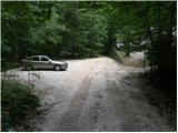
We drive to Kamnik and follow the road ahead towards the valley of Kamniška Bistrica. From the hut in Kamniška Bistrica we continue driving on the forest road which brings us higher to a crossroad, where we continue straight (right Jermanca, starting point for Kamniško sedlo). The road then past Žagana peč brings us to the parking lot at the lower station of the cargo cableway to Kokrsko sedlo.
Driving from the mountain hut in Kamniška Bistrica to the parking lot V Koncu is now forbidden (traffic sign), this extends the path by less than an hour.
Route description:
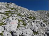
From the parking lot at the cargo cableway we continue on an increasingly rough road which after 10 minutes of walking changes into a cart track. The cart track splits into two parts, and we head to the right one (the left cart track vanishes, or leads towards Gamsov skret), which by the smaller boulder covered with moss (big rock) turns a little more to the right. Right at this spot we leave the cart track and continue straight on at first a poorly visible footpath which later steeply ascends in zig-zags. Steep and mainly in wet dangerous for slipping path leads us over steep slopes, which are on some spots secured with a steel cable. Steep path, which also crosses a few gullies, brings us higher to less steep slopes. After a good hour of walking the path brings us out of the forest, where it starts to ascend steeply again. The path first leads over grassy slopes surrounded by sparse forest, then with the help of some fixed safety gear brings us a level higher. The path ahead passes on to gravel slopes, which somewhat complicate the ascent for us, then the path turns to the left onto steep grassy slopes, which rise above extensive scree fields. At the top of this grassy part we head a little to the right and the path transitions from grass to high-mountain terrain of the basins below Skuta. Further along the path surrounded by cairns we reach a pleasant bivouac below Skuta in a few minutes.
From the bivouac we continue on a poorly visible and still unmarked path along an indistinct small ridge, which after 15 minutes of walking from the bivouac brings us to the marked path Kamniško sedlo - Kokrsko sedlo. Here we continue right and already after a few minutes we reach a junction, where we continue sharply left in the direction of Skuta and Rinka. Just a little further we reach the next junctions, where we continue right upwards in the direction of Rinka (straight Skuta). The path ahead steeply ascends for a short time, then brings us to an indistinct ridge along and beside which we then ascend. Just before the marked path reaches the summit of Mala Rinka, it turns slightly to the left and descends a little to the notch between Mala and Štajerska Rinka. On the other side of the notch the marked path starts ascending again and after a few minutes of further walking brings us to a marked junction, where we continue right in the direction of Koroška Rinka (straight Kranjska Rinka). The path ahead ascends over a band of scree then brings us into a gravel gully, along and beside which we then ascend to the panoramic summit (the mentioned part is exposed to falling rocks).

Photos:
 1
1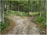 2
2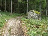 3
3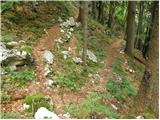 4
4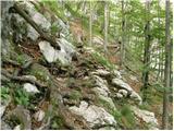 5
5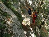 6
6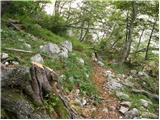 7
7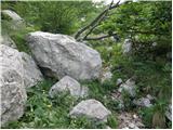 8
8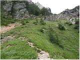 9
9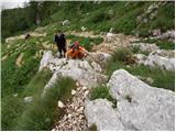 10
10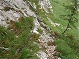 11
11 12
12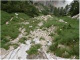 13
13 14
14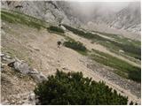 15
15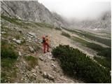 16
16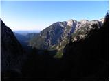 17
17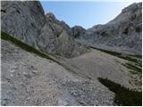 18
18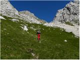 19
19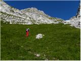 20
20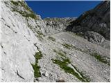 21
21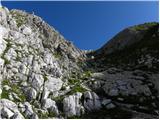 22
22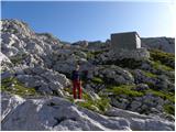 23
23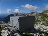 24
24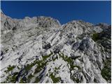 25
25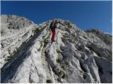 26
26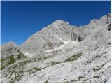 27
27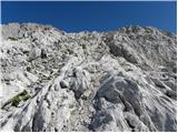 28
28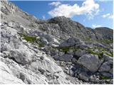 29
29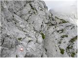 30
30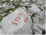 31
3132
 33
33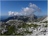 34
34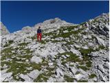 35
35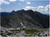 36
36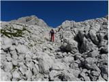 37
37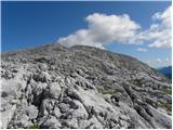 38
38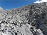 39
39 40
40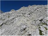 41
41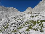 42
42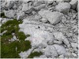 43
43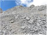 44
44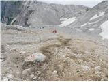 45
45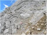 46
46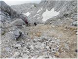 47
47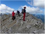 48
48
Discussion about the trip V Koncu - Koroška Rinka (via Žmavčarji)
|
| Gost25. 07. 2007 |
Is the described path (in good weather) hard to find, given that it is not marked?
|
|
|
|
| Gost25. 07. 2007 |
Below there are some cart tracks where you have to be careful to go the right way. From the bivouac to the marked path, the trail is harder to follow, but if you know how to orient a bit, there are no problems. Greetings, Aleš
|
|
|
|
| Gost16. 09. 2007 |
I'm interested if the described path is really an easy path in terms of difficulty. Thanks.
|
|
|
|
| Gost16. 09. 2007 |
On the path there are, I think, two pegs but nothing particularly difficult. In the forest the path crosses a shorter steep section which is dangerous for slipping when wet. Otherwise it's an easy path.
|
|
|
|
| NEIC00827. 07. 2009 |
''The cart track at the smaller boulder covered with moss (large rock) turns right.''
NOT TRUE... THE CART TRACK TURNS LEFT, WE CONTINUE STRAIGHT.. SO NOT RIGHT BUT LEFT.. THE PATH IS NOT EASY BUT QUITE DEMANDING DUE TO SLIPPERY HAZARDS (NOT ONLY WHEN WET) AND DUE TO THE FAIRLY STEEP PATH OTHERWISE NO OTHER SPECIAL FEATURES.
|
|
|
|
| NEIC00828. 07. 2009 |
In the second picture it's already a cart track and not ''worsening road''.. Here the cart track turns LEFT towards Gamsov skret, we continue right. So the description is misleading although ultimately correct.
Yesterday I walked the mentioned path and I know what I'm talking about. In the third picture it is true that something resembling a cart track turns right, we go straight on the well visible path. So, this cart track should be mentioned twice.
|
|
|
|
| NEIC00828. 07. 2009 |
''From the parking lot at the cargo cableway we continue on the increasingly poor road, which after 10 minutes of walking turns into a cart track. The cart track splits into two parts, we take the right one (the left cart track disappears, or leads towards Gamsov skret), which at a smaller boulder covered with moss (large rock) turns even more to the right. Right at this point we leave the cart track and continue straight onto an initially less visible path, which later steeply ascends in zigzags. ''

THIS IS THE EXACT I.E. CORRECT PATH DESCRIPTION.
|
|
|
|
| Mirko0122. 08. 2009 |
I'm looking for the easiest marked path. Who has experience with the path Kokrsko sedlo - Bivak pod Grintovcem - Mali podi - Koroška Rinka? I'm particularly interested in the section between Gorska streža and Sleme, which is marked with a dashed line on the map.
|
|
|
|
| NEIC00822. 08. 2009 |
Nothing special, but I would also warn about one section of the path between Cojzova koča (from the gate) to Bivak pod Grintovcem, which is unpleasant and can also be dangerous for slipping, especially when wet.
|
|
|
|
| pasja_taca20. 08. 2012 |
Planning ascent to Koroška Rinka. I'm interested how long the ascent from the hut at Kokrsko sedlo to the summit takes. Greetings
|
|
|
|
| B.Smart24. 10. 2012 |
Yesterday my colleague and I were at the Rinkas. Wonderful weather and superb views, while the entire Ljubljana basin was wrapped in fog. I must say, this path through Žmavčarje is quite a good fitness test, as the path from the bivouac onwards is a real stroll compared to the previous section. On the north faces of Rinka and Skuta there are already patches of hardened snow, which can be quite slippery and we could have used at least 4-point crampons. Very few visitors at the summit, if I subtract the jackdaws. I think this was one of the last ascents before the snow, as very bad weather is forecast for the next few days.
|
|
|
|
| grand30. 07. 2014 |
Is there still any snow on the path over Žmavčarje to Skuto and Križ?
|
|
|
|
| el rocco13. 08. 2016 |
My wife and I just returned from the trip along this path to Koroška Rinka. The path is technically really undemanding, but you need quite some fitness. Up to the new (by the way really wonderful) bivouac it climbs concretely almost all the time and it can wear out many who lack fitness already midway. Otherwise everything OK, just I would urge the responsible PD to renew the signposts and marks from the bivouac onwards. In sunny weather you probably can't miss it, but it's completely different if it's like this morning when clouds literally covered the area above 2100m. The only reference points for those of us who were there for the first time were the stone cairns placed in the direction of Rinka. At this point I just praise the one who set them up...
|
|
|
|
| Barentoter28. 10. 2016 |
The path via Žmavčarje is an unmarked difficult path, which is why it has its own charm and I hope it stays that way as long as possible. Similar to Gamsov skret, Repov etc. It's good that everyone can choose a path that suits their physical and orientation abilities.
|
|
|
|
| jprim28. 10. 2016 |
It is indeed an unmarked path, but so well-trodden that no markings are needed, and it's not difficult compared to other paths, the difficulty comes from the fact that it's unmarked.
Best regards!
|
|
|
|
| garmont28. 10. 2016 |
The difficulty actually comes from the fact that it is exposed in some places, secured with cables, and that hands are needed for progress in places.
The fact that it's not marked has nothing to do with the path's difficulty. 
|
|
|
|
| jprim28. 10. 2016 |
I have walked the path several times, the cables - minor ones - are only at one spot. I still claim the path is not difficult.
Best regards!
|
|
|
|
| grega_z_brega28. 10. 2016 |
Not for you, but for someone else. 
It depends on the individual. And experienced mountaineers are certainly not the measure.
And there are cables at three spots, one is torn off.
|
|
|
|
| garmont28. 10. 2016 |
I walked the path today. There are cables at three spots and I still claim that the fact that it's an unmarked path has nothing to do with its difficulty. 
|
|
|
|
| smatjaz28. 10. 2016 |
Every mountain path where hand assistance is needed for ascent is considered difficult, whether secured or not. The discussion of whether it is really difficult or not is of course unnecessary and misleading because it is precisely defined when a path is marked as difficult. The fact is that for someone who is 40 and over, and has perhaps been to Šmarna gora 3 times or to Velika planina, this path is even very difficult, but for someone who has already done the entire traverse, it is just varied and interesting and completely undemanding! So be careful with written statements, as they can lead someone to an accident. Above all, everyone should answer for themselves how difficult it seems to them and keep it to themselves. PZS has made a categorization of difficulty and let it help you in unnecessary discussions. And one more thing....before writing about path difficulties, everyone should remember their first steps in the high mountains and perhaps reconsider giving difficulty ratings, and maybe rather describe the course of the path, which would be more advisable. http://www.pzs.si/novice.php?pid=10730
|
|
|
|
| mornar8. 06. 2017 |
Please for information regarding conditions on the path through Žmavčarje to Koroška Rinka. Lp.
|
|
|
|
| trdi20. 10. 2018 |
The fixed ropes to the bivouac are indeed at three places, but in such poor condition that it's already quite dangerous, the first one is actually a rope, the second is so loose that it's no help at all, the third will tear any moment, as it's held together by just one wire.
In addition, on the path to Rinke from the junction to Skuta, refreshing the marks is urgently needed. In my opinion, they were last refreshed about thirty years ago. It's really shameful that you have to build cairns on a marked path. I can't imagine what it would be like if fog caught me.
|
|
|
|
| maks5726. 09. 2019 |
Was it any better this year or is the path still as poorly marked as trdi wrote last year?
|
|
|
|
| redbull26. 09. 2019 |
the path through Žmavčarje is not a marked path, those red dots were drawn by some kid. The path is not marked, but it's well trodden, hard to miss in daylight
|
|
|
|
| redbull26. 09. 2019 |
I wrote only about Žmavčarje, but from the bivouac onwards it is really a bit marked or nicely adventurous with fewer red smudges
|
|
|
|
| maks5726. 09. 2019 |
I don't understand! So to the years when the path was last marked, which trdi mentioned, we can add another year (this one). And Koroška Rinka is supposed to be part of the Slovenian Mountain Trail?
|
|
|
|
| redbull26. 09. 2019 |
that's true, but not through Žmavčarje
|
|
|
|
| maks5726. 09. 2019 |
That's right, however from Kranjska koča at Ledine, where I was on Saturday and saw the warning in front of the hut that the path to Rinka is not maintained and walking on it is at your own risk. My wife and I therefore decided to climb Ledinski vrh and Velika Baba instead.
This week I came across a report by Mrs. Iva Šibav (Planinsko društvo Brda), who wrote about the path to Rinka from Kranjska koča: "The path is secured, but not maintained. In several places the pegs are pulled out, cables torn, markings almost invisible,...................."
In the SPP booklet, my wife and I are missing two two-thousanders, namely Skuta and Koroška Rinka. I can't believe it's so miserable with Rinka, since all other peaks in the SPP booklet that we have conquered so far were nicely maintained and marked.
|
|
|
|
| bbugari126. 09. 2019 |
Really unbelievable that a part of SPP is in such condition. 
What are PZS and PD Kranj doing?
|
|
|
|
| maks5727. 09. 2019 |
I appeal to PZS management:
Ensure that the path to Koroška Rinka meets the standards applicable to other mountains in SPP or remove it from SPP.
|
|
|
|
| turbo28. 09. 2019 |
I appeal to PZS: leave the path through Žmavčarje alone!
|
|
|
|
| jprim29. 09. 2019 |
I can't believe that others also have remarks about the maintenance of hiking trails, until now I was the only one, and my comments were always in vain.
Best regards!
|
|
|
|
| redbull29. 09. 2019 |
move this debate to another path from Jezersko, because the path through Žmavčarje doesn't belong here
|
|
|
|
| jprim29. 09. 2019 |
What a Red Bull dot
|
|
|
|
| NEIC0082. 07. 2022 12:42:10 |
Shamefully very poorly marked path (faded marks). Easier to reach the "marked" path Kokrsko sedlo-Kamniško sedlo than to follow the marks onward. 50% of time lost searching for marks.
|
|
|
|
| dprapr2. 07. 2022 13:37:00 |
On an unmarked path it's really shameful if we can't find the marks.
|
|
|
|
| grega_z_brega2. 07. 2022 16:33:03 |
Why search for marks at all if the path is nicely traceable?
|
|
|
|
| NEIC0084. 07. 2022 13:21:15 |
For dprap:
Literacy is the ability to read and write and, according to UNESCO terminology, the ability to understand everyday messages.
|
|
|
|
| NEIC0084. 07. 2022 13:23:23 |
For grega z brega:
Yes, you're right.. what do we need signs for? Due to poor markings (not renewed since time immemorial), I met many hikers lost in sunny weather, now imagine fog..
|
|
|
|
| NEIC0084. 07. 2022 13:31:16 |
I'm writing about the markings on the marked path Kamniško sedlo - Kokrsko sedlo and the branch to Rinke and NOT about the unmarked path to the bivouac or to the above-mentioned path.
|
|
|
|
| dprapr4. 07. 2022 13:57:05 |
Then you missed the point.
It happens.
|
|
|
|
| di23. 07. 2022 14:30:56 |
I confirm that the marked path to Rinke deserves at least a refresh of the markings, the signpost lower down is also there, but on repetition that option is no longer available).
Whoever relies mainly on the definition of the marked path can easily miss it at least (or even get lost).
|
|
|
To post a comment you must log in:
If you do not yet have a username, you must first
register.