V Koncu - Skuta (via Žmavčarje)
Starting point: V Koncu (900 m)
| Latitude/Longitude: | 46,34200°N 14,56820°E |
| |
Route name: via Žmavčarje
Walking time: 4 h 45 min
Difficulty: very difficult unmarked way
Elevation gain: 1632 m
Elevation difference along the route: 1632 m
Map: Kamniške in Savinjske Alpe 1:50.000
Recommended equipment (summer): helmet, self belay set
Recommended equipment (winter): helmet, self belay set, ice axe, crampons
Views: 106.482
 | 8 people like this post |
Access to starting point:
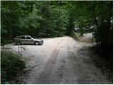
We drive to Kamnik and follow the road ahead towards the valley of Kamniška Bistrica. From the hut in Kamniška Bistrica we continue driving on the forest road, which takes us higher to a junction, where we continue straight (right Jermanca, starting point for Kamniško sedlo). The road then takes us past Žagana peč to the parking lot at the lower station of the cargo cableway to Kokrsko sedlo.
Driving from the Koča in Kamniška Bistrica to the parking lot V Koncu is now forbidden (traffic sign), this extends the path by a little less than an hour.
Route description:
From the parking lot at the cargo cableway we continue on an increasingly poor road, which after 10 minutes of walking turns into a cart track. The cart track at a smaller boulder covered with moss (large rock) turns right. Right at this spot we leave the cart track and continue straight (left gamsov skret) on an initially poorly visible path, which later steeply ascends in switchbacks. The steep and in wet slippery dangerous path leads us across steep slopes, which are secured with steel cable at some places. The steep path, which also crosses a few gullies, takes us higher to a less steep slope. After a good hour of walking the path takes us out of the forest, where it starts to ascend steeply again. The path first leads us across grassy slopes surrounded by sparse forest, then with the help of some fixed protections takes us one level higher. The path ahead transitions to gravelly slopes, which somewhat complicate the ascent for us, then the path turns left onto steep grassy slopes that rise above extensive screes. At the top of this grassy section we head slightly right and the path transitions from grass to the high-mountain world of the basins under Skuta. Further along the path surrounded by cairns we reach the pleasant bivouac under Skuta in a few minutes.
From the bivouac we continue on a poorly visible and still unmarked path along an indistinct ridgelet, which after 15 minutes of walking from the bivouac brings us to the marked path Kamniško sedlo - Kokrsko sedlo. Here we continue right and after a few minutes we reach a junction, where we turn sharply left towards Skuta (slightly left Rinke, straight Turska gora, Okrešelj and Kamniško sedlo). Further the path first gently ascends through the rocky terrain under Rinke. The steepness slowly increases and the path takes us to a scree which we must overcome. When we reach the top of the scree we enter the wall of Skuta. On the path fixed protections help us, mainly pegs. The path then takes us to a small ridge, where steel cables help us, then the path goes back into the wall. Again pegs help us, which take us to the summit part of Skuta. The steepness eases somewhat and soon after we step onto the summit.
V Koncu - bivouac under Skuta 3:00, bivouac under Skuta - Skuta 1:45.

Photos:
 1
1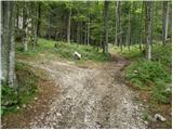 2
2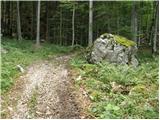 3
3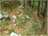 4
4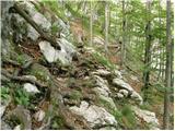 5
5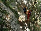 6
6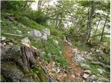 7
7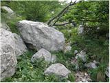 8
8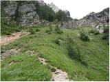 9
9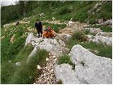 10
10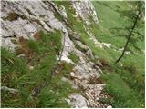 11
11 12
12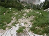 13
13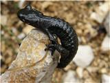 14
14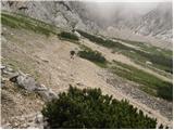 15
15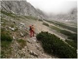 16
16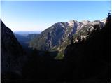 17
17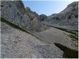 18
18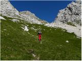 19
19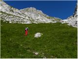 20
20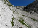 21
21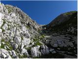 22
22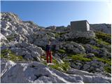 23
23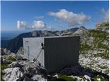 24
24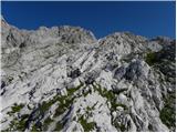 25
25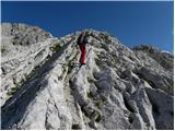 26
26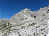 27
27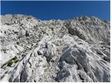 28
28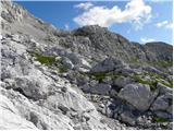 29
29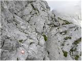 30
30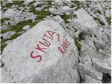 31
31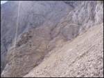 32
32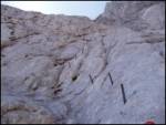 33
33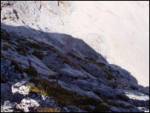 34
34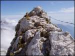 35
35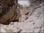 36
36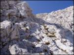 37
37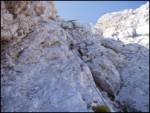 38
38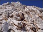 39
39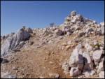 40
40
Discussion about the trip V Koncu - Skuta (via Žmavčarje)
Show older messages
|
| Gost8. 02. 2007 |
Greetings!
Nice path, sometimes very steep but secured with cables and pegs.
hiking greetings
|
|
|
|
| fpetel12. 07. 2007 |
Yesterday I was on this trail. The steepness is a constant companion, so the trail requires quite some fitness. Skuta via Streža is not too crumbly and well protected. Mountain greetings.
|
|
|
|
| Gost2. 08. 2007 |
Hello
My name is John Skuta from the USA and I can't believe there is a mountain named "Skuta".
Good luck in your climbing.
|
|
|
|
| majdicst3. 09. 2007 |
On Saturday (September 1st) we ascended Skuta via this path. The first part through the forest is somewhat unpleasant (risk of slipping), but once above the tree line it becomes interesting. The path is appropriately steep throughout its length. From the bivouac onwards, or from the entry into the wall, it also becomes technically very demanding. That's why reaching the summit is all the sweeter.
|
|
|
|
| Planinko4. 10. 2007 |
Ah, a lots of Skuta. Skuta everywhere!
|
|
|
|
| Planinko4. 10. 2007 |
Cause it is EASY!!!!
|
|
|
|
| nekdo18. 06. 2008 |
I'm wondering how long the path from Konca over Žmavčarje to Skuta would take, down past Cojzova koča? Is there still any snow on the path or until when is it supposed to last?
|
|
|
|
| viharnik8. 06. 2008 |
For a good mountaineer the tour takes a good part of the day. That means to the bivouac 2.30h, to Skuta 1.30h, down a bit faster, to bivak Pavla Kemperla 1.30h, Kokrško sedlo less than an hour, and to the valley to the cargo cableway 1.15h. Don't know about snow, but there will definitely be some on the crossing gullies and passes despite the south aspect! -ice axe mandatory! and cautious route, greetings Rok.
|
|
|
|
| nekdo19. 06. 2008 |
until when is the snow supposed to last? since I'm not very experienced on snow so no sense in risking...
|
|
|
|
| viharnik9. 06. 2008 |
You made the right decision regarding postponing the tour. I advise you to choose tours based on your current experience and gradually build on them. Don't rush with tours, that way you better learn perception of movement coordination and terrain as well as awareness and calming of the mind. I think in about a month the snow will be mostly gone. Nice hikes!
|
|
|
|
| majdicst10. 06. 2008 |
nekdo1, this is exactly the path I did last year. The times mentioned by viharnik are quite "tough". We were with a group of fairly solid hikers, yet we still needed 5 hours to Skuta, from Skuta past Štruca and under Dolgi hrbet (past the bivouac under Grintovec) to Zoisova koča about 3.5 hours, down to the starting point ca. 1.5 hours, total therefore a good 10 hours. But that's all including rests, snacks...
I fully agree with viharnik that you'd better wait for dry conditions. The path is no ordinary walk and it's better to go in conditions where you'll enjoy it.
|
|
|
|
| nekdo110. 06. 2008 |
definitely 
but just let me know when the path will be more or less dry
|
|
|
|
| nekdo123. 06. 2008 |
I would go on the trail on Wednesday, so if anyone has hiked it recently, let them tell if there are any "special features"
|
|
|
|
| Brane716. 07. 2008 |
Today my colleague and I went along this path to Skuta. Before entering the wall there are two steep snowfields that can be crossed with plenty of caution. The path in the wall is well protected with pegs. Since you're mostly in the sun, you need to put a bit more liquid in your backpack. As one of the predecessors wrote, the steepness is a constant companion on the entire path, so you need quite some fitness. At the top, everything is rewarded with wonderful views.
|
|
|
|
| sk26. 07. 2008 |
Especially in the morning (today) it was hard so you couldn't stick the crampons, the ice axe came in handy right away.
How do I add a picture 
|
|
|
|
| morris7. 07. 2008 |
I was on this path yesterday and the day before. Early in the morning the snowfields are very hard (ice axe is highly recommended), during the day they soften, but that doesn't mean we can be careless on them. Here we can easily find snowfields with a safe runout that are very suitable for slipping and stopping exercises. Inexperienced can learn a lot here about movement and situations in summer snow. In many huts you will find the brochure "Mountaineer's Advisor", where slipping exercises,... are described in more detail. GOOD LUCK!!!
|
|
|
|
| NEIC00811. 07. 2010 |
Which path to Skuta is more demanding, from the bivouac below Skuta or from the bivouac below Grintavec?? I've reached both from both sides, but not yet to Skuta...
|
|
|
|
| brish11. 07. 2010 |
Definitely, the ascent to Skuta from Malih podov, where the bivouac under Skuta is located, is very demanding. I advise you to go to Skuta from the bivouac under Grintovec, through Velike pode to the saddle between Dolgi hrbet and Štruca, from there through Štruca to the summit.
Lots of enjoyment and safe steps! Regards
|
|
|
|
| JusAvgustin26. 11. 2010 |
super tour, especially interesting in winter conditions...
|
|
|
|
| mancar26. 11. 2010 |
I was here this summer - beautiful, completely enthusiastic. I see that I am a good mountaineer - according to viharnik - and it feels just fine to me :-))
Unfortunately, I didn't see any chamois, so ..have to repeat!
|
|
|
|
| viharnik26. 11. 2010 |
But I really am not some standard for evaluating a mountaineer, although in years of mountaineering I have already walked quite a few and climbed a bit less. It is true that I personally post more tours, which some perhaps cannot manage due to family and other obligations.
|
|
|
|
| JusAvgustin26. 11. 2010 |
modesty is a beautiful virtue...
|
|
|
|
| mancar29. 11. 2010 |
you're right, geolog. I won't anymore. What's important is what you take from the path within yourself, not how fast you hike it.
|
|
|
|
| gasperv11. 07. 2011 |
Hiked the trail yesterday. Passable without issues. Before entering the wall of Skuta, we cross two small snow tongues.
Nice tour with beautiful views.
|
|
|
|
| ruševec31. 08. 2011 |
Yesterday evening I went for the third time via Žmavčarje to the bivouac under Skuta. On this path on Monday morning, except for chamois on the scree, no one. From the bivouac up, beautiful views opened. When I stepped onto the marked path, I turned right towards Turski žleb. Then happily spotted the path junction. From that junction to the top of Skuta I went first. First interesting gymnastics on pegs a bit up a bit down. Then some scree and entry into the climbing part of the path. After 5 minutes of climbing, a clatter. Rocks? No one yelled watch out. In the next moment I see the culprits don't know how to speak It was a chamois goat and kid, only 10 m away. They posed a bit in front of the camera, then I continued. The path is really well secured most of the way. Just a bit below the summit the protection is sparse, but the rock is solid and full of good holds. When I stepped onto the summit of Skuta, the northern horizon opened. All the way to the Hohe Tauern in Austria! I descended past the bivouac under Grintovec via Kokrsko sedlo. This path is much easier and more suitable for descent. Wonderful weather, wonderful tour, Skuta is really a beautiful mountain.
|
|
|
|
| pohodnik3821. 07. 2012 |
For me the most beautiful path to Skuta that gives you everything from views, flowers along the path and some adrenaline when ascending the well-secured path to the summit.
VIDEO
|
|
|
|
| gorskarozica3. 08. 2012 |
On Wednesday we set off via Žmavčarje to Skuta. The trail itself is very praiseworthy, beautiful, also a bit marked, but we needed more time before we reached the top of Skuta. Maybe we were slower, or the trail norm is for exceptionally fast, especially young guys. Markacists, you are super, the trail is well described also for ordinary hikers. Best regards
|
|
|
|
| pohodnik387. 08. 2012 |
On Sunday 5.8. up this very nice path to Skuta and continuation over Dolgi hrbet-Mlinarsko sedlo to Grintovec... nice and unforgettable
VIDEO
|
|
|
|
| gorski svizec19. 10. 2012 |
Since I haven't gone to Skuta via Žmavčarje yet, but plan to do so tomorrow, I'm interested in your opinion whether frozen snow from the last days can still be expected on any part of this path?
Thanks for the reply and best regards.
|
|
|
|
| pohodnik3820. 08. 2013 |
Some video impressions from the path - filmed with a helmet camera for a better idea of the route
VIDEO
|
|
|
|
| pohodnik382. 09. 2013 |
Some snapshots in picture and word from this wonderful path which is always nice to walk.
Skuta(2013)
|
|
|
|
| abes9. 09. 2013 |
I walked the mentioned path on Saturday. The last time I was on Skuta was 10 years ago and yes, I had already forgotten what a beautiful mountain it is. When you look towards the summit from the Bivouac, it's really an impressive sight...
|
|
|
|
| rok.si4. 10. 2013 |
Is it possible to get lost on this path if you don't know it (despite map, description and signs)? In the forest it's probably trodden, but what about above the tree line? Thanks!
|
|
|
|
| pohodnik384. 10. 2013 |
Above the forest line, it is even easier to follow the path as it ascends through meadows and across vast scree fields, so it is clearly visible and quite trampled.
|
|
|
|
| Daaam4. 10. 2013 |
From my memory, the hardest part is to "find it" at first, then it goes o.k.... someone even quite badly "marked" the lower part with spray... bandit...
|
|
|
|
| rok.si5. 10. 2013 |
Thanks, I didn't get lost - only near the top, where there are two huge scree fields, I went a bit my own way, then found the cairns again and soon the bivouac too. The spray is almost overcome by nature, it's already quite faded.
|
|
|
|
| Daaam5. 10. 2013 |
Rok.si-Nice to hear/read that the spray is hardly visible anymore.. When I went up there last time it was still quite fresh, best regards
|
|
|
|
| rok.si5. 10. 2013 |
In the forest it is more noticeable, but when the trees thin out, it starts to fade.
|
|
|
|
| soncyka17. 10. 2013 |
Hi. Has anyone gone recently over Žmavčarje to Skuta? How is the snow? Is it passable without winter gear? I anyway feel that the long ridge is not doable currently.
|
|
|
|
| smatjaz26. 07. 2015 |
GPS track from V Koncu via Žmavčarje past the bivouac under Skuta, Skuta via Slovenska. Descent via Štruca to Velike pode and under the Štruca wall pathless to the entrance of Gamsov skret and through it to the valley in V Koncu.
http://www.hribi.net/gps.asp?sledid=557
|
|
|
|
| pohodnik385. 09. 2015 |
Trail hiked in the second half of August, which is not so hard to follow. Perhaps only the start might be a bit unknown to those going for the first time. Every year in August I head up this trail to Skuta, this year also with a visit to the new bivouac on Malih Podih.
PICTURES and personal impressions from the trail
Regards! Tone
|
|
|
|
| M4A3G2. 07. 2016 |
Are crampons still needed on this path to Skuta?
|
|
|
|
| alexandra20. 07. 2016 |
I remember this path being very steep, so it's probably not recommended in wet conditions. Given the high probability of rain tomorrow afternoon in these parts, I'm wondering if it makes sense to wait a few days or if it's not that bad after all. I'm thinking of going tomorrow afternoon or Friday morning. Please, some advice Thanks!
|
|
|
|
| matzaj25. 07. 2016 |
Hello.
Weather experts - will the weather hold tomorrow for visiting Skuta from Kamniški konec (via Žmavčarje) and return via Kokrsko sedlo.
Start around 4:30 from Konec? Return around 13-14h!
Best regards
|
|
|
|
| katjah2. 08. 2016 |
Hi! On Sunday I'm heading along this path to Skuta. I'm wondering if the path is clearly visible and if you had trouble following it? Is it possible to reach the new bivouac under Skuta also via another marked path?
Thanks for the advice and best regards! Katja
|
|
|
|
| macice26. 09. 2016 |
Is it now open below to the parking lot?
|
|
|
|
| macice26. 09. 2016 |
I assume you can go around it?
|
|
|
|
| redbull26. 09. 2016 |
Did they close it? Ugh, now we'll have to go from K. Bistrica
|
|
|
|
| grega_z_brega26. 09. 2016 |
No no.
just a bit of fooling around for fun
|
|
|
|
| Martin kokot3010. 07. 2017 |
I'm wondering if it's possible to go up through the Turski zleb or if it's in ruins.
|
|
|
|
| Jure8710. 07. 2017 |
On Saturday there was a notice on the hut at Kamniško sedlo that the path from the saddle to Turska gora is closed due to a landslide, but there was no information about the Turski žleb. Call Okrešelj for accurate information.
|
|
|
|
| Enka10. 07. 2017 |
You can also check the Current Conditions forum
|
|
|
|
| Cockta23. 07. 2017 |
Today my boyfriend and I climbed Skuta via this path. Steep, but very interesting and well-protected path return via Kokrsko sedlo. During the return the sole came off boyfriend's shoes.. a friendly man helped us who solved it in a very special way
|
|
|
|
| rasto_r28. 08. 2017 |
In Kamniška Bistrica no driving ban sign is visible. Anyway, you couldn't even park there due to the crowd. Over the weekend everything was parked from Žagana peč to the cable car.
|
|
|
|
| rasto_r1. 09. 2017 |
The path from Skuta down to Male Pode is in my opinion quite nasty due to scree and quite deficient protections. For ascent it's probably easier anyway.
|
|
|
|
| ggorenc9. 11. 2017 |
I was on Skuta a few weekends ago. Still as steep as ever and rocks fly over Žmavčarje as if people up there were competing who would release more of them. Please be careful up there. A half-meter rock flew five meters from me. Someone up there did apologize to me but that doesn't help much.
|
|
|
|
| strajnarR7. 08. 2018 |
Yesterday via Žmavčarje to the bivouac and further to Skuta. As ggorenc mentioned, watch your step and be careful. First I heard an interesting rattling and just watched where it would come flying from, a half-meter rock whizzed by a few meters away. In front of me, or rather on the summit I didn't notice anyone.
|
|
|
|
| pohodnik3810. 08. 2018 |
Yesterday 9.8. to Skuta via this path through Žmavčarje the path is without features no snow anymore even below Skuta. But I would mention picture 39 of this description caution is not superfluous as it seems to me namely the whole rock hangs on the cable which is tensioned like a string above only two bolts hold in the cracked rock. I rather avoided it on the left side. Easier climbed approx 2-3 m and above stepped onto the path that goes across
PICTURES and some personal details from the path
Best! Tone
|
|
|
|
| MPS13. 07. 2020 |
Little film from the hike to Skuta. Ascent via Žmavčarje and past the bivouac below Skuta. To the valley I went past the bivouac below Grintovec via Kokrsko sedlo. Both routes are normally passable without winter gear. Video at the link: Skuta (2532 m), 4.7.2020I hope it will help someone to get a better idea of the route itself. Stay safe in the mountains. Best, Mirko
|
|
|
|
| Enka13. 08. 2020 |
On the path via Žmavčarje last weekend the first fixed rope was completely unusable (twisted into a coil by the trail), but in dry conditions no issues here. The second is very loose, someone hooked it to a piton that's already quite wobbly, so caution. At the third fixed rope the first part is ok, the second part torn, but it can be used as aid for pulling up. For descent probably a bit trickier. From here to Skuta summit the trail is without peculiarities, overall very nice.
|
|
|
|
| Turbolazec24. 10. 2020 |
Oh, does anyone know what the current conditions are like? Is it dry, at least partially?
|
|
|
|
| Janiel7414. 11. 2020 |
Oh. I was there yesterday 13.11. up this path. The initial climbing section to the ridge with fixed cables is full of ice in the upper half, with a little ice below and a small amount of fresh snow above it. I went very carefully and with good grip I didn't feel it slipping too much. But this section is quite in the shade and question how it is day by day. Above, it was still necessary to step carefully and cross in some sections. To the other side towards Cojzova dolina no problems.
|
|
|
|
| M E S A18. 07. 2022 17:36:54 |
Yesterday on this path to Skuta. The trail is well followable. But markings on the designated section from the four-trails junction at Malih Podih towards Skuta need renewing.
|
|
|
|
| Kinki4. 07. 2023 20:24:58 |
Hey. Does anyone know what the conditions are like on this path to Skuta? I'm mainly interested if there's any snow?
|
|
|
|
| Marko M29. 07. 2023 17:58:21 |
Hi
Has anyone been to Skuta via this path these days?
I'd appreciate info if there are any dangerous snowfields left, and if I need crampons and ice axe?
Thanks!
|
|
|
|
| bongo29. 07. 2023 22:57:36 |
Hi, you no longer need winter gear on the mentioned path. Before entering the wall there's still a small snowfield that poses no problems, the ironware is in good condition. Good luck
|
|
|
|
| jax30. 07. 2023 11:58:56 |
That snowfield can also be bypassed. You don't need to step on snow at all anymore.
|
|
|
|
| SaMoMe29. 07. 2024 20:49:39 |
I would be grateful if someone tells me if the road to the cable car in Koncu is passable and if one is allowed to drive there. Two years ago it was possible. Thanks.
|
|
|
|
| Janez Seliškar30. 07. 2024 11:50:29 |
Currently, the parking lot at the lower station of the cargo cable car to Kokrsko sedlo is not accessible by car (marked with an appropriate sign).
|
|
|
|
| SaMoMe30. 07. 2024 20:36:43 |
Janez Seliskar, thanks for the reply.
|
|
|
|
| cen8. 09. 2024 14:39:02 |
Beautiful trail, very demanding in terms of fitness. Shame it's not marked.
The entry to the start of the trail is somewhat different from the description due to torrent devastation. Where the last parking lot ends, the path is cut off after a few meters. We can follow straight up the stream bed (Y branch, follow the right one). After about 100m, watch on the left bank where the forest "opens" to the original path, next to it is a small cairn.
|
|
|
|
| boruthor18. 06. 2025 16:28:01 |
Is there still any snow, or can it be done without winter gear?
Thanks
|
|
|
|
| funnyboy18. 06. 2025 20:02:14 |
A few days ago they wrote that it is necessary to cross some snow patches before entering the difficult part of the path under Skuta.
|
|
|
|
| Nodi12319. 06. 2025 13:37:39 |
Was up yesterday. From the mentioned part you need to cross approximately 5 snow patches, however the snow is soft, so winter equipment is not necessary, some poles for support in the snow don't hurt.
|
|
|
To post a comment you must log in:
If you do not yet have a username, you must first
register.