Belska Kočna - Vellacher Turm/Storžek
Starting point: Belska Kočna (968 m)
| Latitude/Longitude: | 46,40230°N 14,56640°E |
| |
Walking time: 3 h 15 min
Difficulty: very difficult marked way
Via ferrata: B
Elevation gain: 1142 m
Elevation difference along the route: 1142 m
Map: Kamniške in Savinjske Alpe 1:50.000
Recommended equipment (summer): helmet, self belay set
Recommended equipment (winter): helmet, self belay set, ice axe, crampons
Views: 24.644
 | 1 person like this post |
Access to starting point:
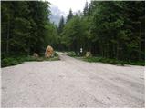
First, we drive to Jezersko, and then we continue driving in the direction of Austria. The road from Jezersko in a few hairpin turns ascends to the border crossing Jezerski vrh, and from there in numerous hairpin turns starts descending steeper. Lower at the settlement Bela / Bad Velach, we come to the marked crossroad, where we continue right in the direction of Belska Kočna / Velacher Kotschna. The road ahead crosses the stream Bela and only a few meters ahead brings us to the next crossroad. Here we continue straight on the right road and we continue driving by the already mentioned stream. We follow this road to the arranged parking lot by the barrier, which prevents further driving.
Access is also possible over the saddle Pavličevo sedlo. In this case, at the settlement Bela we continue left. Further, we follow the above description.
Because of the construction of a new forest road (data from the year 2009) on the mountain pasture Jenkova planina, the parking lot by the barrier can be full of logs, therefore we park already a little lower on a suitable place by the road.
Route description:
From the parking lot, we continue on the road, and after 3 minutes of walking, it brings us to a crossing. We continue straight, further on the road in the direction of the valley Logarska dolina (right Goli vrh). We follow the gently sloping road for a little less than 20 minutes to the spot, where the marked path branches off to the left upwards. Further, we ascend on an at-first wide path, which through the forest in a moderate ascent brings us to a torrent stream, where the path turns right, crosses the stream and then brings us to a secured part of the path.
With the help of a steel cable we ascend a slightly exposed ridge, which is short and undemanding in dry conditions. The path ahead ascends among bushes with beautiful views on the surrounding peaks. Most striking is the pointed Storžek, to which we are getting closer. Ahead the path runs past a pleasant spring, after which we soon get to an old hunting cottage, which is surrounded by lush vegetation.
The path then ascends for some time among bushes and sparse forest, after which we step into the embrace of larches. The terrain ahead is becoming more and more high-alpine and larches are replaced by scree, which due to its leeward position remains under snow for quite a long time. Across the scree a fairly steep and increasingly panoramic path leads us towards the saddle Savinjsko sedlo. A few minutes before the saddle we will notice on the right side of the path a large inscription on the rock “Klettersteig”. Here we leave the path towards the Savinjsko sedlo and head right upwards on a somewhat less trodden trail. The path, which is further marked with red dots, soon brings us to the entry into the climbing section of the path. The climbing path initially with the help of a steel cable and pegs crosses the steep eastern slope of the mountain towards the north. The path then turns left and steeply ascends along the steel cable upwards. Later the path brings us to a steep partly grassy slope, where caution is needed as the path is often slippery. In the last part of the path we turn left and a short ascent follows on the unsecured slope towards the summit.

Along the route: Lovska koča Presteralše (1469m)
Photos:
 1
1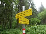 2
2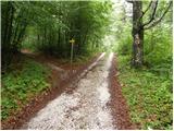 3
3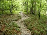 4
4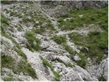 5
5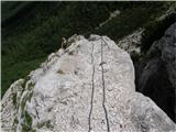 6
6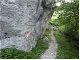 7
7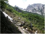 8
8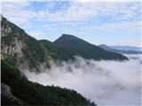 9
9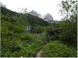 10
10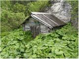 11
11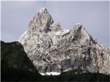 12
12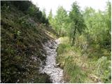 13
13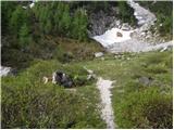 14
14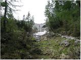 15
15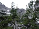 16
16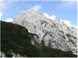 17
17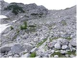 18
18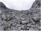 19
19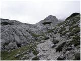 20
20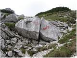 21
21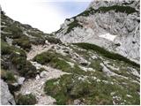 22
22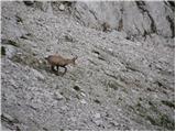 23
23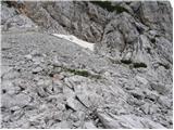 24
24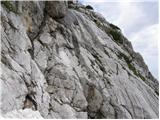 25
25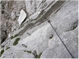 26
26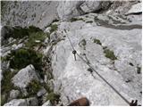 27
27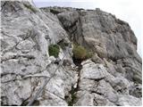 28
28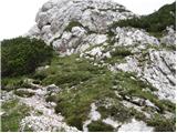 29
29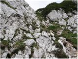 30
30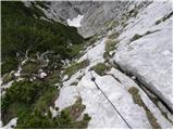 31
31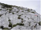 32
32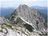 33
33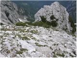 34
34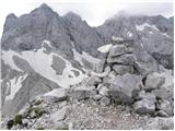 35
35
Discussion about the trip Belska Kočna - Vellacher Turm/Storžek
|
| andrejjerina14. 07. 2009 |
Today the described path to Storžek was done, it's worth it because of the wonderful views from Mrzla gora to Kočen. The fixed protections are in impeccable condition! I recommend. Best regards Andrej
|
|
|
|
| EUGEN10. 09. 2009 |
Mountain for lovers of quiet corners.
Been 3 times and haven't met any hikers yet.
|
|
|
|
| acjom10. 09. 2009 |
Three weeks ago the trail was closed due to a rockfall, are there still any problems on the trail?
|
|
|
|
| Matjaz_654. 10. 2009 |
no problems ... just the cables hanging in the air in a few places ... but no issue 
there was another visitor behind me at the top ... otherwise a beautiful day and excellent visibility 
Photos
|
|
|
|
| Gorazd G5. 10. 2009 |
It's true what matta writes. About a month ago Davo explained it nicely to me that Storžek was ALWAYS Belski turn, but at the same time self-critically added that the locals are themselves to blame for some "new" names (Storžek is not the only case), because during the renaming they were not persistent and determined enough for their voice to be heard.
|
|
|
|
| acjom5. 10. 2009 |
Since I also tried to do the described path, but I think I didn't find the right starting point.
At the foot of the serpentines I turned right and then almost in the valley at a bend again right into the forest, which I think was not correct, because there was no large parking lot anywhere, I think that large parking lot is right by the road further on from that junction. Thanks, if someone explains it to me in more detail, because I hope for another nice Sunday in October.
|
|
|
|
| Matjaz_656. 10. 2009 |
Yes ... when you mentioned it, I remembered that I also saw a junction that would probably mislead me ... if coming from the Jezersko direction 
from the main road turn right onto the road toward Pavličevo sedlo ... after maybe 2 km ... when the road turns sharply left ... continue straight on gravel to the barrier and parking ... sign for Belska Kočna already at the junction ... also a nature reserve
|
|
|
|
| pika6. 08. 2011 |
The solitary Storžek was quite well visited today, but I think it wasn't bad for him. Clouds and then light rain chased us too quickly from the very panoramic summit. Otherwise, the road is drivable to the barrier, the trail newly marked.
|
|
|
|
| grega_p22. 08. 2011 |
Excellent tour, especially suitable in these hot days due to the shady location. I slept at the top and admired the night outlines of the mountains and the vast universe. Despite the stone bed, it was a wonderful experience.
Everyone has their own new paradise.
Enjoy. With chamois by the side...
Grega
|
|
|
|
| katty22. 08. 2011 |
Wow, I believe that experience was wonderful. I quite envy you
Best regards
|
|
|
|
| kolosej25. 09. 2011 |
You can also nicely reach Storžek from Ravenska Kočna past Ledin and Jezersko sedlo, where we descend towards Savinjsko sedlo and before it turn onto the marked path from Belska Kočna.
|
|
|
|
| Domch29. 06. 2013 |
Also from Belska Kočna a very nice tour about two and a half hours long. The climbing path is nicely secured, with good holds and not too demanding. At the entrance there was a larger snowfield that can be bypassed from above. I agree with the predecessors that it's a very nice peak with great all-around views. The summit will slightly disappoint stamp collectors, as it has neither a stamp nor a logbook. This is the only peak in KSA that lies entirely on the Austrian side. Definitely worth a visit.
|
|
|
|
| sirt129. 06. 2013 |
It is the only two-thousander that is entirely in Austria.
No hard feelings
|
|
|
|
| garmont29. 06. 2013 |
No, no, Austria has quite a few two-thousanders that are entirely in Austria.
It holds that Storžek is the only peak in KSA that lies on the Austrian side.
|
|
|
|
| sirt130. 06. 2013 |
The only peak over 2000m in KSA, lower ones can be found too.
|
|
|
|
| jvali5. 09. 2013 |
On Saturday I plan to visit this peak from the direction of Pavličev sedlo. Among the descriptions above someone was looking in vain for parking, but apparently from the direction of Ravenska Kočna. So is the starting point for Storžek from Pavličev sedlo well marked or do I need to pay attention to something special? Really thanks for the answer. val.
|
|
|
|
| jvali5. 09. 2013 |
Wrote too quickly and mistyped. I mean Belska Kočna. Although the hike and access from Ravenska Kočna is also possible.
|
|
|
|
| halls1. 07. 2014 |
Does anyone know what the current condition is? Still any snow?
|
|
|
|
| scorpio2. 07. 2014 |
At the entry still quite a lot of snow, so approach a bit higher (watch out - there's a hole between snow and wall). Careful also with the pitch, as the first 5 pegs are broken. I was yesterday on Storžek: buddy on the secured path, me on the ridge, where you can also get nicely (probably around II), just quite airy.
Good luck and be careful!
|
|
|
|
| dprapr18. 10. 2014 |
“Klettersteig” in fairly poor condition. Cables slack and pegs ripped out in several places.
From our side definitely much nicer approach along the short, airy ridgelet.
|
|
|
|
| VanSims11. 07. 2016 |
The problem is only three consecutive pulled-out pegs in the initial pitch and even that only downhill. The other four pulled-out pegs higher up are individual and in completely unimportant places.
For someone who masters belaying on foreign ferratas, who knows why the cables are slack and who descends in retreat style, i.e. facing the rock, the short but quite crumbly unprotected section somewhere in the middle of the path can be problematic. Except downhill at the aforementioned pitch, I struggled more there than anywhere else on the ferrata.
So those with experience on at least medium-range ferratas abroad, go ahead boldly! "Klettersteig" is in what I would call satisfactory condition, but not quite good.
Oh, and thank God I didn’t have to (like a bit earlier on Baba) switch every three seconds.
|
|
|
|
| Ksandi29. 10. 2017 |
Today I was at the summit of Storžek via this path. In the upper part of the via ferrata in the gully there is snow partially covering the fixed cables, but it's still possible to reach the top.
|
|
|
|
| Robie7. 07. 2019 |
Yesterday on Storžek, nice path, protections poor - pulled/broken pins, loose cables. Requires caution on those sections.
Valley start has sign allowing drive - parking access 1.4.-2.11. 5-18h, otherwise prohibited.
Water at spring ~1:15 from parking.
|
|
|
|
| suhi20006. 09. 2024 16:59:37 |
On 1.9.24 the path condition is even a bit worse. Only a third of the pegs still hold the cable. Half are broken, half pulled out.
In short, think carefully if you want to go up, because you have to descend the same way.
Otherwise, the path from Belska Kočna is beautiful and quite solitary even on weekends.
|
|
|
To post a comment you must log in:
If you do not yet have a username, you must first
register.