Velika Zaka (Bled) - Mala Osojnica (via stairs)
Starting point: Velika Zaka (Bled) (480 m)
Route name: via stairs
Walking time: 25 min
Difficulty: partly demanding marked way
Elevation gain: 211 m
Elevation difference along the route: 211 m
Map: Karavanke - osrednji del 1:50.000
Recommended equipment (summer):
Recommended equipment (winter): ice axe, crampons
Views: 59.706
 | 3 people like this post |
Access to starting point:
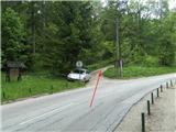
From the highway Ljubljana - Jesenice we take the exit Lesce and drive towards Bled. When we arrive in the mentioned tourist town, we drive through it straight in the direction of Bohinjska Bistrica. We drive past the settlement Mlino and also drive past Hotel Vila Bled, whereupon at the crossroads we drive to the right (left goes towards Bohinj). When the road in 3 - 4 turns descends near the lake (Njivice), we drive a few more 10 m along the lake in the direction of Zaka. About 400 m before Velika Zaka, where there is usually the finish of regattas, on the left side of the road we notice a macadam road and next to it hiking signposts. We drive onto the latter and park in an appropriate place (parking spot next to Dom muzealcev Slovenije is reserved for guests).
Route description:
From the parking lot we continue uphill to Dom muzealcev Slovenije, where before the building we first turn slightly right, then left, where we step onto the path that leads into the forest towards Osojnica. When we step into the forest, we head right along the marked trail uphill (by the marking is number 6).
The path soon in zigzags begins to lead us towards the summit. Somewhere in the middle, we first encounter a steel cable that helps us over the less exposed traverse, immediately after which almost all the way to the top a wooden railing is offered in assistance. There follow one or two necessary turns so that we find ourselves in front of high almost vertical numerous metal stairs that climb along the rocky wall towards the summit. (On descent in wet conditions danger of slipping). Next to it there is also a metal railing. When we climb to the top, a bench awaits us, the path continues to the left, where soon on an otherwise undemanding section we again meet the wooden railing. When after that the path first descends left towards the edge, it rises a little to the right once more, thus soon reaching the fenced panoramic summit with benches and an information board.

Photos:
 1
1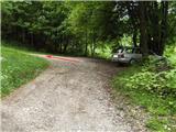 2
2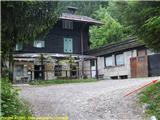 3
3 4
4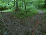 5
5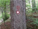 6
6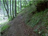 7
7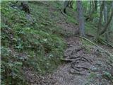 8
8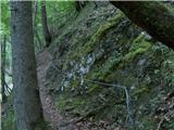 9
9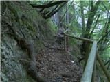 10
10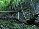 11
11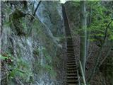 12
12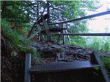 13
13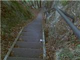 14
14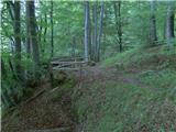 15
15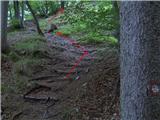 16
16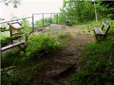 17
17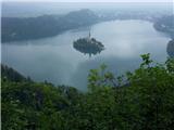 18
18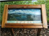 19
19
Discussion about the trip Velika Zaka (Bled) - Mala Osojnica (via stairs)
|
| heinz14. 05. 2009 |
Despite its seemingly innocent and short nature, M. Osojnica has claimed victims from visitors in the past. For example, last year on 2.10., when an Australian hiker slipped during descent and died on the spot, while a mountain rescuer was seriously injured during the search for the deceased.
Well, the trip itself looks really great! Anyone who hasn't been there yet should go as soon as possible..I recommend it!
|
|
|
|
| Parkeljc4. 11. 2009 |
Today, with a colleague, I went along the described path to Mala Osojnica. In nice weather there must really be a nice view from this "hill". Where the stairs are in the picture, I really warmly recommend ascent and not descent, especially on wet ground, as we had a shepherd dog with us who started whining from fear. Well, the view was nice despite the snow flurries. Then we climbed to Velika Osojnica - nothing special, no special view. We then descended to the saddle and after a five-minute ascent arrived at Ojstrica. From here is the nicest view towards Bled and the Karavanke. All together it took about an hour and a half. Just right to sweat. The peculiarity of the path to me is the unusually large number of ticks along the path. Super.
|
|
|
|
| heinz5. 11. 2009 |
When you're already in Bled, it's worth visiting Straža via Riklijeva pot, which is located roughly above the Toplice hotel, otherwise better known for the ski jump or summer toboggan run located on its northern slope. You can find the description under the hike Želeče (Bled) - Straža (Riklijeva pot).
|
|
|
|
| darh1. 04. 2010 |
Last Saturday as part of a longer trip around the lake we also climbed Mala Osojnica, but preferably via the longer path past Ojstrica. The view from Ojstrica seemed better to us too than from Osojnica. You can read more about our feat here.
|
|
|
|
| VanSims12. 09. 2010 |
Even though a fatal accident has already occurred on this trail (because a hiker strayed off the path in fog), I see no reason for the partially demanding rating. This rating can unjustly scare someone who is unsure and afraid of more demanding trails.
|
|
|
|
| Darxta9. 02. 2013 |
Yesterday I went up in the snow and at the beginning you need to be quite careful with the markers, which have arrows drawn next to them that can confuse a person a bit. I definitely recommend looking at the markers well in advance.
Best up this path, down past Ojstrica.
View: FENOMENAL!!! 
|
|
|
|
| JutranjaZarja16. 04. 2014 |
trees are lying everywhere, the path is impassable and dangerous!
|
|
|
|
| MiciA1. 05. 2014 |
I just came from M. Osojnica (path: past the Muzealcev Lodge). Really, trees are lying everywhere, but in dry weather and with "brains in your feet" you reach the top without major issues. Nice view compensates for some sweat trapped in the shirt.
|
|
|
|
| metod1. 05. 2014 |
I agree with what's written. I searched for the natural bridge on Mala Osojnica a week ago, but couldn't find it. Does anyone know where it can still be found?
|
|
|
|
| always_cocacola20. 02. 2015 |
Today my boyfriend and I headed on the described path towards Osojnica. The path is suitable for the season, but the cable is ''torn'' from the rock and the further fence is half collapsed... so we turned back as we didn't know what awaited us higher... 
|
|
|
|
| heinz20. 02. 2015 |
It seems Infrastruktura Bled is not doing its job properly (or no longer authorized). Quite sad for potential tourists.
Higher are steep stairs, which if not properly maintained can become dangerous. Considering everything, in this winter time probably best to use path past Ojstrica.
|
|
|
|
| lucca24. 02. 2015 |
Last time we were there, the sign in front of the stairs was crossed out with red tape, have you perhaps noticed that? From asking around, the path has been closed for quite some time. So you have to go past Ojstrica. 
|
|
|
|
| Šuška5. 03. 2015 |
Can anyone tell me what the path past Ojstrica to Mala Osojnica is like?
|
|
|
|
| Šuška6. 03. 2015 |
I don't doubt it's muddy, I'm more interested in difficulty, time etc. Is there anything written somewhere about the exact route?

|
|
|
|
| heinz6. 03. 2015 |
The path is easy. We start on the gravel road (macadam) that ascends to the right past the Home of Slovenian Museologists, so next to the above-described starting point. Higher up it narrows into a cart track that later brings us near Ojstrica on the right. Here the path turns slightly left and then ascends more steeply through the forest. When the steepness eases, the path turns left (right to Velika Osojnica) and after a few minutes' walk through the forest, partly along a precipitous edge, brings us to the viewpoint at Mala Osojnica.
The path is partly marked, occasionally (towards the end) we have to follow the more trodden direction.
Walking time approx. 1 hour.
This description is not yet available here.
Best, H!
|
|
|
|
| Šuška7. 03. 2015 |
Great, many thanks
|
|
|
|
| Mira.k29. 03. 2015 |
The trail via the stairs is still closed, I went there today and was very disappointed. I was particularly interested in the stairs. I think the Bled tourist workers could take better care of their excursion points. Sad.
|
|
|
|
| penkob18. 04. 2015 |
Hi, I'm wondering if this path is still closed? If it is, could you recommend another viewpoint on Lake Bled? thanks
|
|
|
|
| penkob18. 04. 2015 |
How does the path look? Snowy?
|
|
|
|
| opazovalec30. 01. 2017 |
Exceptionally picturesque description for reliving, for those who haven't had the chance to head to the island these days. On Saturday the weather still allowed views from afar.
|
|
|
|
| babica 522. 02. 2023 16:41:17 |
Since there hasn't been any comment for quite a few years, I'm wondering if anyone knows the current situation on the path. Is it time to visit yet? Is there also a stamp at the top?
|
|
|
|
| heinz22. 02. 2023 23:35:46 |
The path was maintained by Infrastruktura Bled at the time the description was created. Maybe they can give you some information. Personally, I doubt the steps are dry enough for a safe descent yet.
|
|
|
|
| tjabi24. 02. 2023 10:34:52 |
The path is still maintained by Infrastruktura Bled. About two weeks ago they sawed and removed broken branches. The steps are still icy.
|
|
|
|
| babica 53. 01. 2024 16:53:43 |
Is there a stamp at Osojnica or Ojstrica as well?
|
|
|
|
| georgia3. 01. 2024 18:29:00 |
No (at least until last year there wasn't). But there are wonderful views and benches...
|
|
|
To post a comment you must log in:
If you do not yet have a username, you must first
register.