Vezovje (avtobusna postaja Vezovje most) - Rifnik
Starting point: Vezovje (avtobusna postaja Vezovje most) (270 m)
| Latitude/Longitude: | 46,19119°N 15,41130°E |
| |
Walking time: 45 min
Difficulty: easy marked way
Elevation gain: 298 m
Elevation difference along the route: 305 m
Map:
Recommended equipment (summer):
Recommended equipment (winter): ice axe, crampons
Views: 350
 | 1 person like this post |
Access to starting point:
We leave the Štajerska highway at the Dramlje exit, then follow the signs for Šentjur. From the center of Šentjur, we continue briefly towards the settlement of Šmarje pri Jelšah, but soon turn right onto the road towards Podsreda and Planina pri Sevnici. Šentjur soon ends, and we drive almost to the beginning of the settlement Vezovje. About 100 meters before the mentioned settlement, a road branches off to the left by the bus stop, leading towards the settlement Gorica pri Slivnici (the turn-off isn't marked). We turn left, drive over a bridge, and park in an appropriate place. We park in a way that does not hinder traffic, locals, or possible forestry or other work.
Route description:
From the bus stop, we continue on the main road towards Šentjur, and we quickly reach a smaller hamlet, where we turn onto a marked path that leads us among the houses, and we bypass the house on the right on its upper side. Next follows a diagonal ascent on a cart track; the cart track higher up turns left and brings us to a solitary house, where the path turns back towards the right. We continue walking on the cart track, and when we reach a poorer road before the next house, we go sharply left. Next follows some crossing towards the left, where a nice view opens up from the grassy parts. The path ahead leads us past an abandoned house; from a smaller crossing, where we reach a macadam road, we go left, at first slightly downwards. When we leave the forest a little further on, we reach an asphalt road, which we follow right upwards (straight downwards Resevna).
Next follows a few minutes of ascent on the asphalt road, then we go right from a smaller crossroad, where the path leads us by a pasture. On the other side of the pasture, we ascend into the forest, and in the forest, we continue left on a slightly longer marked path. Next follows a short, easy descent, and we join the path from Šentjur.
Here we go right, and in a few minutes of further walking, we arrive at a viewpoint and an inscription box on Rifnik, with the highest point located a minute further by the renovated ruins of an archaeological site.
Description and pictures refer to the condition in November 2023.

Photos:
 1
1 2
2 3
3 4
4 5
5 6
6 7
7 8
8 9
9 10
10 11
11 12
12 13
13 14
14 15
15 16
16 17
17 18
18 19
19 20
20 21
21 22
22 23
23 24
24 25
25 26
26 27
27 28
28 29
29 30
30 31
31 32
32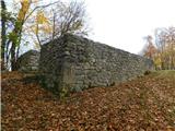 33
33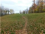 34
34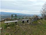 35
35 36
36 37
37 38
38 39
39
Discussion about the trip Vezovje (avtobusna postaja Vezovje most) - Rifnik
To post a comment you must log in:
If you do not yet have a username, you must first
register.