Vikrče - Grmada (Pogačnik way)
Starting point: Vikrče (320 m)
| Latitude/Longitude: | 46,12850°N 14,44460°E |
| |
Route name: Pogačnik way
Walking time: 1 h
Difficulty: very difficult marked way
Elevation gain: 356 m
Elevation difference along the route: 356 m
Map: Ljubljana - okolica 1:50.000
Recommended equipment (summer): helmet, self belay set
Recommended equipment (winter): helmet, self belay set
Views: 52.802
 | 6 people like this post |
Access to starting point:
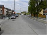
A) From the Ljubljana - Jesenice highway, we take the exit Ljubljana - Šmartno, then continue driving towards Tacen. In Tacen, just before the road over the bridge crosses the Sava river, we continue slightly right towards Pirniče. Only a little after Ljubljana ends, we arrive in Vikrče, and we follow the road to the inn Kovač, which is located right next to the bus stop. At the starting point, there are no appropriate parking spots.
B) From Šentvid, we drive to Tacen; there, immediately after the bridge over the Sava river, left towards Pirniče. Only a little after Ljubljana ends, we arrive in Vikrče, and we follow the road to the inn Kovač, which is located right next to the bus stop. At the starting point, there are no appropriate parking spots.
C) From Medvode, we drive to Zgornje and then to Spodnje Pirniče, and we follow the road towards Tacen. When we arrive in Vikrče, we join the road which leads from Smlednik towards Tacen; here we continue right and follow the road to the nearby inn Kovač, where the starting point of our path is. At the starting point, there are no appropriate parking spots.
D) We can also arrive at the starting point by LPP bus no. 15.
Route description:
From the inn Kovač, we first walk along the road leading towards Tacen; then, when the main road makes a slight right turn, we continue slightly left onto a narrower local road (at the crossroads there is a sign prohibiting driving, near the sign there is also an information board for the forest educational trail on Šmarnogorska Grmada). Along the narrower asphalt road we walk to a private parking lot, then continue sharply left onto a rougher road that gently ascends among log piles (straight ahead: Grmada via Mazijeva steza and Šmarna gora over Zatrep).
Along the mentioned road we walk some tens of meters, then arrive at the start of the climbing path to Grmada. The path to the start of the climbing path is poorly marked.
Here, the signpost for Pogačnikova pot to Grmada (very demanding path) directs us right upwards. The well-secured path first leads us steeply up a narrow gorge, then the path temporarily flattens somewhat and brings us to a traverse to the right. With the help of safety gear, we quickly manage the traverse, then arrive at the most difficult part of the path. The path ahead climbs vertically up the vertical wall, and in addition to the pegs, a steel cable assists us, to which we can attach a self-belay kit. Once we climb the vertical pegs, the path becomes a grade harder, as it becomes slightly overhanging. After climbing the short overhanging wall, the path gradually enters the forest, and the steepness also gradually decreases. A little higher, Westrova pot joins from the left (we can descend via the mentioned path); we continue right and proceed with the ascent along the forest-covered western ridge of Grmada. We follow this path all the way to the mentioned summit, from which a nice view opens up.

The trip can be extended to the following destinations: Šmarna gora
Photos:
 1
1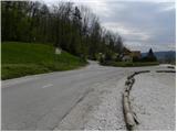 2
2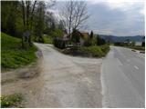 3
3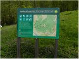 4
4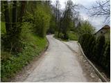 5
5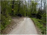 6
6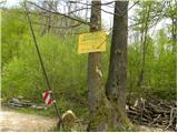 7
7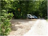 8
8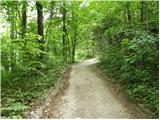 9
9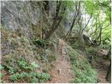 10
10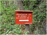 11
11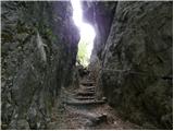 12
12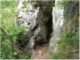 13
13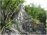 14
14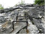 15
15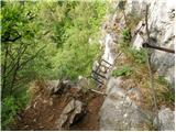 16
16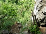 17
17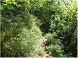 18
18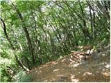 19
19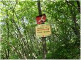 20
20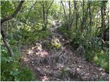 21
21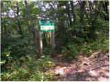 22
22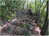 23
23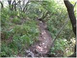 24
24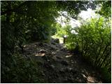 25
25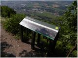 26
26 27
27
Discussion about the trip Vikrče - Grmada (Pogačnik way)
|
| Gost9. 05. 2007 |
The trip would be nicer if there weren't so many people on Grmada and Šmarna gora!
|
|
|
|
| Fazo1. 03. 2009 |
But those people could at least greet ... such Šmarna gora and Grmada are nicer evening variants... even then there are quite a few people. ... such Šmarna gora and Grmada are nicer evening variants... even then there are quite a few people.
Regards, Matevž
|
|
|
|
| matic428. 03. 2009 |
The climbing part is quite short, then it's quite steep. At the top of Grmada there's an interesting panoramic sign. Down is not significantly harder than up. But I'd advise against it when the trail is muddy. The last part to the climbing section is quite steep, in muddy conditions that can mean a slide. I didn't meet many people, maybe five.
|
|
|
|
| reina25. 10. 2009 |
Last time my friend and I wanted to go to Grmada from Šmartno. We're not from Ljubljana and we followed the instructions from these pages, the electric pole in the middle of Šmartno but unfortunately we couldn't find it. We found two locals who directed us to Vikrče.
Thanks for any better information and best mountain greetings.
|
|
|
|
| ben25. 10. 2009 |
All you need is to find the church in Šmartno (it's quite big)  , there by the road look for the telephone booth. Ten meters ahead there are new signs on the pole for Šmarna gora. Higher up in the forest you have at least two marked ascent options to ŠG. The left one is somewhat gentler and brings you to the summit via the saddle, straight ahead or Partizanka is somewhat steeper and takes you directly to the summit. Good luck! , there by the road look for the telephone booth. Ten meters ahead there are new signs on the pole for Šmarna gora. Higher up in the forest you have at least two marked ascent options to ŠG. The left one is somewhat gentler and brings you to the summit via the saddle, straight ahead or Partizanka is somewhat steeper and takes you directly to the summit. Good luck!
Regards B
|
|
|
|
| Gorecan25. 05. 2010 |
Nice regards, I'm interested if the use of a via ferrata kit is mandatory?
Thanks for the answer and best regards
|
|
|
|
| grega_p25. 05. 2010 |
The debate is quite old and has been discussed many times, but anyway: The use of a via ferrata kit depends greatly on your skills and experience on climbing paths. Here it's about 100 meters of exposed climbing section (mostly ladders). Personally, I've never used it here, but that's a personal decision. If you're a beginner, using SVK is essential, but it's definitely highly recommended.
Think about what exposure, height, exposure, overhangs mean to you and how firm your grip is in that.
Safe travels anyway!
|
|
|
|
| Gorecan25. 05. 2010 |
Thank you very much for the info. Best regards
|
|
|
|
| viharnik25. 05. 2010 |
The Pogačnik climbing route from Vikrče to Šm. Grmada is safe and nicely continuously secured, so it won't cause problems for mountaineers experienced with via ferratas. For new visitors to such routes, I still recommend self-belaying, especially since the upper exposed section of the wall with ladders somewhat overhangs transversely from the wall and the body pulls outwards to the left while climbing. In wet conditions, the rock here is quite smooth and slippery due to heavy traffic, so a little caution won't hurt unprotected visitors.
|
|
|
|
| Enka17. 10. 2011 |
Climbed the climbing section in both directions. Fun, adrenaline-packed. But it's true what someone already wrote - in good conditions, down is no harder than up.
|
|
|
|
| Domch29. 03. 2012 |
Very poorly marked and you have to be a real trail follower to find this path. Also the path description to the parking is poorly described and parking in the village Vikrče is a problem. Best is at the inn.
|
|
|
|
| Marx18. 08. 2012 |
The climbing section is truly unique, especially the beginning in the rock canyon. But, the start of the path has not even one single mark, no arrow, nothing. Luckily they know how to get to the starting point at the Kovač inn...
|
|
|
|
| krevs3318. 11. 2012 |
Today we "climbed" this path for the second time and it was excellent. The only problem was that it was very slippery.
|
|
|
|
| francimedved19. 11. 2012 |
Marx, I'll bring it up at the Šmarna gora mountaineering club to get it sorted.
|
|
|
|
| viharnik19. 11. 2012 |
How slippery, when I went up while water was still running down the rocks after the rain? I even went up in sneakers. Of course rock on frequented paths isn't like in pathless terrain, but you can walk normally without slipping if you weight the step properly at the angle of max friction and find suitable holds sideways. Mountaineering club probably won't grind the rocks with an angle grinder.
|
|
|
|
| francimedved20. 11. 2012 |
No, we certainly won't grind the rocks, but we have some planned work in the gully.
|
|
|
|
| tinky21. 11. 2012 |
Pogačnikova is super, just short. If you don't know Šmarna gora or Grmada, the starting point is really hard to find. Slippery in many places.
|
|
|
|
| katty25. 04. 2013 |
Today I climbed this path to Grmada for the first time. The parking lot was quite full, but actually only 3 of us climbed it... I was quite surprised. Okay, it was really super duper, at least you have peace, no one "chases" you.
But I would just write a few remarks: before finding the starting point it's quite a project.... Signs that you go climbing here could be placed already by the road. The problem here is also parking, as those few spots are quickly taken. Here the rule "first come, first served" really applies. There are obviously too few markers, at least on the initial part of the path. The climbing path is otherwise super duper well maintained, all praise. The rocks are already quite worn in places, but okay, as good as it gets.
Definitely this is a solid 10, so I'll come back.
|
|
|
|
| francimedved25. 04. 2013 |
At Pd. Šmarna gora we have already agreed that we will soon install signs for this path from the main road to the starting point. As for parking, we can't do anything, all plots are private.
|
|
|
|
| godlike25. 04. 2013 |
A little further from the Westrova path there is a junction.
When I was there, it was full of cars along the edge of the road, so I parked there too and walked back to the starting point.
|
|
|
|
| francimedved25. 04. 2013 |
A little further from the Kovač inn there used to be quite some space on the left side of the roadway. But when they opened the parking lot at the former Lipa discotheque (paid), they brought soil there and made parking impossible. There is still some space for parking around here, but not much.
|
|
|
|
| jax26. 04. 2013 |
As I already said in another thread: you can park for free (at least I think you still can) also at the church or Mercator in Pirniče. Then it's a couple of minutes walk on asphalt, but anyway. As for parking on the left side of the road at the turn-off to Pirniče, I heard that it might no longer be possible. Now I don't know how it really is.
|
|
|
|
| matdra26. 05. 2013 |
I went on this path, but got lost on the way up, so descended the climbing gully. The path is extremely well protected, airy and especially suitable for beginners wanting slightly harder peaks. Good training ground anyway.
|
|
|
|
| francimedved13. 07. 2013 |
We have placed a signpost for this trail by the main road, so it will now be easier for those going for the first time.
|
|
|
|
| matej12318. 07. 2015 |
First time on this trail, no parking issues as there's an informal parking spot opposite the trail. The path is well marked. I tried the self-belay kit for the first time on the trail and it's excellent for beginners, but I noticed more than half go along this path without protection.
|
|
|
|
| VanSims18. 07. 2015 |
That parking by the trail is private and I wouldn't risk it. Best to leave the car at the Police Academy. It's a 5-10 min walk, but the car is safest there.  At the academy there's no sign prohibiting parking. At the academy there's no sign prohibiting parking.
Regarding the kit, I agree. First of all, it really is a path for testing and introducing the use of SVK.
Secondly, from that half that goes up without the kit, there's almost a fatal victim every year. The ferrata doesn't yet reach the difficulty of e.g. Gonžarica where there have only been two deaths so far, but mostly trained hikers go there who mostly secure themselves, whereas on this ferrata all sorts of people go without and with securing.
|
|
|
|
| zavratčan16. 10. 2016 |
how high is the vertical ascent
|
|
|
|
| viharnik16. 10. 2016 |
About eight meters, no more.
|
|
|
|
| alexs132010. 05. 2019 |
The best thing about this short ferrata is the fact that it's 15-20 min away from Ljubljana. The second best thing is that you can make a nice photo during the sunset, at the very beginning of the ferrata (narrow space between two cliffs). I would give it 10 and 8.
From a technical perspective, it's not very interesting, as there are ladders and those U-shaped steps where you put your feet. Nothing attractive, just a big fall beneath you and trees to obscure the view. 3 Stars.
View from the top is ok but nothing breathtaking, 5 stars.
The most important thing: although it's short, and it seems trivial, take samozavarovalni komplet (ferrata set), don't die in a very stupid way. You would not be the first one to do it on that place.
Am I going to visit it again - yes.
Is it good for the beginners - yes.
For the first time - no, it's not attractive at all, go to Hvadnik, Kanin or Mojstrana.
|
|
|
|
| Aljaž.M10. 05. 2020 |
Very suitable path for beginners and short, I recommend to beginners  but no great view but no great view . .
|
|
|
|
| balon3. 08. 2022 20:31:21 |
Aljaž, thanks. It will come in very handy.
|
|
|
|
| balon27. 09. 2022 09:14:47 |
It was wonderful. As Aljaž already wrote, the path is suitable for beginners, I also warmly recommend it.
|
|
|
|
| balon27. 10. 2022 10:42:46 |
This was our first via ferrata, but still I'm curious how you would categorize this ferrata? With what grade I mean.
|
|
|
|
| Trobec27. 10. 2022 16:46:30 |
It is categorized as a very demanding mountain path 
I do agree though that these labels are quite deficient and often do not realistically describe the path.
|
|
|
|
| balon28. 10. 2022 08:28:11 |
|
|
|
To post a comment you must log in:
If you do not yet have a username, you must first
register.