Vikrče - Šmarna gora (Pogačnik way)
Starting point: Vikrče (320 m)
| Latitude/Longitude: | 46,12850°N 14,44460°E |
| |
Route name: Pogačnik way
Walking time: 1 h 30 min
Difficulty: very difficult marked way
Elevation gain: 349 m
Elevation difference along the route: 400 m
Map: Ljubljana - okolica 1:50.000
Recommended equipment (summer): helmet, self belay set
Recommended equipment (winter): helmet, self belay set
Views: 106.266
 | 9 people like this post |
Access to starting point:
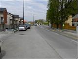
A) From the Ljubljana - Jesenice highway, take the Ljubljana - Šmartno exit, then continue driving towards Tacen. In Tacen, just before the road over the bridge crosses the Sava River, continue slightly right towards Pirniče. A little after Ljubljana ends, we arrive in Vikrče, and we follow the road to the inn Kovač, which is located right next to the bus stop. At the starting point, there are no appropriate parking spots.
B) From Šentvid, drive to Tacen; there, immediately after the bridge over the Sava River, turn left towards Pirniče. A little after Ljubljana ends, we arrive in Vikrče, and we follow the road to the inn Kovač, which is located right next to the bus stop. At the starting point, there are no appropriate parking spots.
C) From Medvode, drive to Zgornje and then to Spodnje Pirniče, and follow the road towards Tacen. When we arrive in Vikrče, join the road leading from Smlednik towards Tacen; here continue right and follow the road to the nearby inn Kovač, where the starting point of our path is. At the starting point, there are no appropriate parking spots.
D) The starting point can also be reached by LPP bus number 15.
Route description:
From the inn Kovač, first walk along the road leading towards Tacen; then, when the main road makes a slight right turn, continue slightly left onto the narrower local road (at the junction there is a no-driving sign, and near the sign an information board for the forest educational trail on the Šmarna gora Grmada). Along the narrower asphalt road walk to the private parking lot; there continue sharply left onto the poorer road, which gently ascends among piles of logs (straight: Grmada via Mazijeva steza and Šmarna gora over Zatrep).
Along the mentioned road, walk some 10 m, then arrive at the start of the climbing path to Grmada. The path to the start of the climbing path is poorly marked.
Here the signpost for Pogačnikova pot to Grmada (very demanding path) directs us right upwards. The well-secured path first leads through a narrow gorge relatively steeply upwards, then the path temporarily flattens somewhat and brings us to a traverse to the right. With the help of the fixed protections, we quickly manage the traverse, then arrive at the most demanding part of the path. The path ahead climbs vertically up the vertical wall; besides the pegs, a steel cable assists us, to which we can attach the self-belay kit. Once we climb the vertical pegs, the path becomes a grade harder, as it becomes slightly overhanging. When we climb the short overhanging wall, the path gradually enters the forest, and the steepness also begins to ease gradually. A little higher, Westrova pot joins from the left (we can descend via the mentioned path); we continue right and continue the ascent along the forest-covered western ridge of Grmada. We follow this path all the way to the mentioned summit, from which a nice view opens.
From the top of Grmada, continue along the marked path, which begins to descend through the forest. After approximately 15 minutes of descent, the path brings us to the saddle Sedlo between Grmada and Šmarna gora, where we join the path from Tacen and Šmartno pod Šmarno goro.
Continue along the road, from which a footpath to Šmarna gora soon branches off. From here, we have two options to the summit.
We can ascend to the summit along the forest road, which takes us past the wish bell and the children's playground, or along the steep footpath, which past the chapel brings us to the summit in a few minutes, where both paths join.

Photos:
 1
1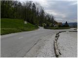 2
2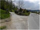 3
3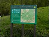 4
4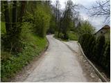 5
5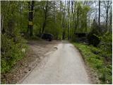 6
6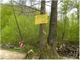 7
7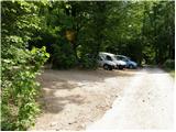 8
8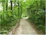 9
9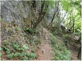 10
10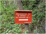 11
11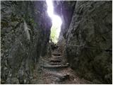 12
12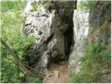 13
13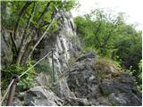 14
14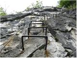 15
15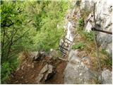 16
16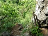 17
17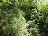 18
18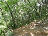 19
19 20
20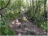 21
21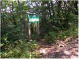 22
22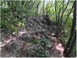 23
23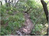 24
24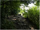 25
25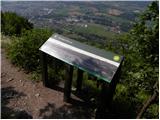 26
26 27
27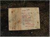 28
28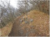 29
29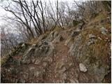 30
30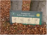 31
31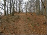 32
32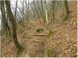 33
33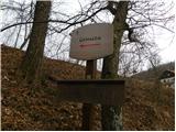 34
34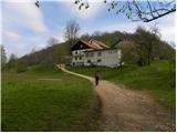 35
35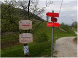 36
36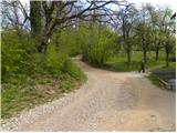 37
37 38
38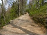 39
39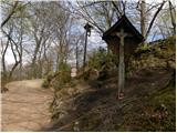 40
40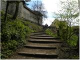 41
41 42
42 43
43
Discussion about the trip Vikrče - Šmarna gora (Pogačnik way)
Show older messages
|
| fpetel121. 02. 2008 |
The climbing path is slightly overhanging in places. There are enough fixed protections - in places it is also exposed, so I recommend self-belaying - but it warmed me up nicely even without  The climbing section of the path is unfortunately - or fortunately - only just under 10' long The climbing section of the path is unfortunately - or fortunately - only just under 10' long
|
|
|
|
| Biser gora28. 03. 2008 |
The climbing section is really short, but technically I think it is harder than from Planika to Triglav. Namely at one spot, 5m ascent, the path is even overhanging. The full protection kit is really not superfluous. lp
|
|
|
|
| NEIC00814. 09. 2008 |
The path is interesting. Of course, there's no comparison with high mountain paths already due to the altitude, but I agree that this otherwise very short path requires some strength, especially in the arms. It's OK for training..
|
|
|
|
| Okmodko19. 04. 2010 |
From Kredarica to Triglav there's no such part anywhere. But it's short, so the adrenaline and ethanoloidin end quickly. When you're there you're scared, when you're at the top of Šmarna you'd go again, the dilemma is present, it lasts even today, if I decide for this path again, I'll go like a man.
|
|
|
|
| lepenatka19. 04. 2010 |
I think these two paths are not comparable... for a little dose of adrenaline, and for training definitely, I recommend "Pogačnik", for a bit more Gradiško.
Enjoy.
|
|
|
|
| Johannes5. 08. 2010 |
Interesting path, especially the initial part is quite adrenaline-pumping, but the path is well secured and there are no major concerns.
Also suitable for a kind of test for Triglav, to get a feel for what the path to Triglav from Planika or Kredarica should be like.
|
|
|
|
| jer.128. 08. 2010 |
The path is great for a bit of adrenaline but the climbing section is quite short. I recommend self-belaying as some parts of the path are quite exposed.
|
|
|
|
| Ukec9. 08. 2010 |
I'm wondering about that parking lot shown in the picture. Does the owner object if you park your car there, given the sign stating it's private parking?
|
|
|
|
| viharnik9. 08. 2010 |
No issue. Everyone parks there, including many free climbers. But leave the truck access open, as they occasionally store and haul wood from there.
|
|
|
|
| bagi9. 08. 2010 |
It greatly depends on the current mood of the owner of this land from the nearby farm. There will come a day when he chases you away from every spot, including the one in the picture. Other times you can talk to him quite normally. My advice is, if you have to park here, do it like in the photo and leave maximum space for the tractor. Don't park behind the ramp or anywhere along the road. The owner is quite allergic to that and diligently places various obstacles there. No problem parking a bit higher along the main road and walking a few extra minutes to the starting point.
LP Bagi
|
|
|
|
| Janiel7421. 07. 2011 |
climbed it for the first time before always only easy marked paths...now this...adrenaline rush...with via ferrata set...
|
|
|
|
| Ceri20. 09. 2011 |
How can you compare the path from Planika/Kredarica to Triglav with this 10-minute scramble to Grmada?? 
|
|
|
|
| Loni20. 09. 2011 |
Pogačnikova is slightly overhanging in places, so you have to rely on arm strength.
|
|
|
|
| lukecpukec20. 09. 2011 |
It's hard to compare these three paths... Pogačnikova may be technically more demanding (as the previous one wrote - overhanging in places), but it's generally shorter. The difference is also that on Pogačnikova you have a fixed cable most of the time where you can secure yourself with a via ferrata set, whereas on the ascent to Mali Triglav (from Kredarica) you have only pegs in some places where self-belaying is not possible. Besides, I think you're much more exposed to falling rocks on the path to Mali Triglav than on the path to Grmada...
|
|
|
|
| irena.komatar21. 01. 2012 |
The path is really nice for those who like a bit of climbing (short and sweet) I didn't have a via ferrata set, but I still warmly recommend it. I didn't have a via ferrata set, but I still warmly recommend it.
|
|
|
|
| Branee20. 05. 2012 |
come on, today I went, climbing path is a joke, pegs + cables every decimeter and then you say how demanding it is, yeah for someone who never saw it, maybe. For a mountaineer it's just a walk..
|
|
|
|
| Branee20. 05. 2012 |
self-belay kit, from my point of view, is not necessary
|
|
|
|
| fpetel120. 05. 2012 |
I've been on most secured paths in Slovenia, but this Pogačnikova doesn't appeal to me much. Everything is in iron and adrenaline is quite high despite the protections (last time I was in the wet). For beginners, the self-belay kit is definitely mandatory.
|
|
|
|
| francimedved22. 05. 2012 |
Well, we did make the steps wooden.
|
|
|
|
| ljubitelj gora22. 05. 2012 |
@Branee: Don't mislead people, this secured path is the closest to Ljubljana and we shouldn't take it lightly, it says it's a very demanding path, requires helmet and via ferrata set.
|
|
|
|
| Ulčnik22. 05. 2012 |
I'm a local and know this path, so I can tell you there's no need for a via ferrata harness
|
|
|
|
| van22. 05. 2012 |
Demanding? Depends on the person.
|
|
|
|
| Janiel7423. 05. 2012 |
@kucelj: I agree with you. Well, some don't care about themselves or they have something cat-like in them (read 9 lives)
|
|
|
|
| Zebdi23. 05. 2012 |
Well, if someone is wondering whether they need a via ferrata set or not, then they should take it. Personally, I never used it on this path (and didn't miss it at all), but it's true that climbing is quite familiar to me...
|
|
|
|
| mako444. 12. 2013 |
Now I really don't understand anymore... were we so stupid back then or is something wrong today? Via ferrata set, OK, have it but I think too much is too much! First you need to get your head straight, then other things. Climb the ladder to the top of the house. If you can't do that, leave such paths. I used to take kids there, OK, I belayed them, and they were a bit offended... were you really that small..
Happy trails and enjoy the mountains!
|
|
|
|
| jax4. 12. 2013 |
Well. I myself have never belayed on Pogačnikova either (heck, I've probably gone through it more often in sneakers than in mountain boots), but it's not that easy either... If we look strictly technically, it's quite more demanding than the "more seriously" treated path on Gradiška tura and almost certainly more demanding than all approaches to Triglav (well, maybe except for plemenice, I haven't been there). Of course, it's hard to compare.
|
|
|
|
| Kita4. 12. 2013 |
The path to the local hill is really not comparable to paths to Triglav at all, let alone the ascent from Kredarica to the top... The ridge on Gradiška tura is not exactly a walk either... The ridge on Gradiška tura is not exactly a walk either...
|
|
|
|
| jax4. 12. 2013 |
It's not a walk, but it's easier than Grmada. Definitely.
|
|
|
|
| Kita4. 12. 2013 |
For you maybe it is and for many others too... But then the guidebook authors need to be warned not to mislead people; because in most guidebooks Gradiška tura is substantially more demanding than this path to Grmada... I've been to Gradiška, not yet to Grmada but even from the picture it's clear that Grmada is nowhere near as demanding as Gradiška tura...
|
|
|
|
| korl5. 12. 2013 |
What stupid comparisons, so what does the name of the hill even matter, and whether you puffed for five hours on walking mulatieras before you reached the first belay on Triglav?
It makes absolutely no difference if you flip over the overhang onto the rocks from 30m height on Šmarna or from 300m on Triglav, both times they stuff you into a body bag. The memorial plaques aren't there for nothing.
|
|
|
|
| pikica15. 12. 2013 |
@korl you have no idea what you're talking about. Even more cursed is how long the tour is. Just look at the people who drag themselves to Kredarica with their last strength. Then they push to the top. Since they're already right on the edge of their strength, their concentration quickly fails and the accident is here.
As for 30m or 300, it really doesn't matter.
You can break your neck even if you slip on the fourth rung at the ladder while picking apples.
|
|
|
|
| korl5. 12. 2013 |
What are you trying to say with that, that I should pick apples with a via ferrata set too?
|
|
|
|
| Branee5. 12. 2013 |
@korl, what are you climbing in the tree for while picking apples
|
|
|
|
| VanSims5. 12. 2013 |
300m - they take you to Žale, 30m - at least you can be an invalid for the rest of your life.
You can be ever so confident in your abilities, we are humans and we make mistakes. Besides, all sorts of things can happen that have nothing to do with our experience level: say a stone flies (whether dislodged by a fellow climber or an animal or just like that, it doesn't matter), it can just hit you enough to make you jerk (even if you have a helmet on, which of course you do) and you're already ciao ciao... you can feel bad, a piton or bracket can be loose,...,... there can be a hundred reasons!
A responsible mountaineer secures himself on via ferratas, even if short or just on a short section.
|
|
|
|
| van5. 12. 2013 |
Anyone who needs a via ferrata set for Pogačnikova pot is better off not going on via ferratas.
|
|
|
|
| Loni6. 12. 2013 |
The helmet didn't help my buddy under Jalovec either, my father died practically on the flat under Nanos. From the "it can happen" category.
So, if someone feels safer with a via ferrata set, let them have it. Regardless of which via ferrata.
|
|
|
|
| Hribolaznik12. 04. 2014 |
Today on Pogačnikova... Starting point bus stop Vikrče (5 cars parked at bus parking). Extremely beautiful and short tour, excellent preparation or preview for following more demanding ascents like Kopiščarjeva on Prisojnik or Via Italiana on Mangart. Ascent only to intersection with Westrova trail, then descent back to Vikrče on that trail. Total 35 minutes with obligatory photographing Short and sweet
|
|
|
|
| Lisica8. 04. 2017 |
Nice path to Grmada and Šmarko. Below that steep final section there is also a bypass on the right side.
Shame, no arranged parking nearby.  I wouldn't park right at the bus stop. What about the bend before the bus stop on the same side where there's a farm, people park there... is it allowed? I wouldn't park right at the bus stop. What about the bend before the bus stop on the same side where there's a farm, people park there... is it allowed?
|
|
|
|
| Macesna9. 04. 2017 |
Those bypasses under the last steep section are not recommended, as they are not secured (or the piece of cable there is not very reliable). This means you have to climb a chimney on the bypass to the frej.
Better to stick to the official secured path.
|
|
|
|
| A.D.K.9. 04. 2017 |
@Lisica....you can park at the Police School, there's a huge gravel parking lot. To the starting point you then have 5-10 min walk, just right for warming up. You can return via one of the paths that leads practically directly back to the parking lot and thus have a nice circular option.
|
|
|
|
| Lisica9. 04. 2017 |
Thanks. I'll try maybe next week already. 
|
|
|
|
| Alias989814. 07. 2017 |
To me this trail is by far less demanding than Gradiška Tura. I haven't used a via ferrata set on it yet, but I don't see why someone (say, who isn't confident) wouldn't... in the final analysis it's just a plus, no downside.
|
|
|
|
| binep22. 08. 2019 |
Yesterday for the first time on Pogačnikova trail. Nice circular tour via Grmada and Šmarna gora back to Vikrče. There is no arranged parking nearby, I parked on private property (picture 7), where you are supposed to arrange by phone if you can park or not, unfortunately two numbers are missing from the sign
|
|
|
|
| Ficla20. 08. 2020 |
Today my boyfriend and I went on this trail for the first time. We parked at the parking lot shown in the seventh photo and had no problems.
Otherwise, I would add that a via ferrata set is very welcome. The trail is short, but mishaps or mistakes can still happen, just like on longer trails. I also doubt that a huge soft pillow awaits you below in case of a fall . I'd rather play it safe.
|
|
|
|
| nejcf4. 03. 2021 |
Today after school we jumped with classmates along the Pogačnik trail to Grmada and then to Šmarna gora. Temperatures just right, and the usual weekend crowds weren't there. Turnc is really great, shame only that the trail is so short. The private parking lot in picture 8 no longer exists; it's built up and full of agricultural machinery. As some have already mentioned above, there are plenty of parking options on Rocenska street at the police academy.
|
|
|
|
| garmont24. 02. 2022 08:37:11 |
The start of the path is now nicely marked.
|
|
|
|
| Hribolazec8126. 03. 2022 22:14:15 |
Where can one park safely?
Because as I read you have problems with parking and people
|
|
|
|
| bongo27. 03. 2022 09:18:52 |
The safest is at the paid parking lot, then walk past the academy and Sava bistro along the main road towards the starting point.  At Rocenska by the academy it can be crowded, but it's also an option. At Rocenska by the academy it can be crowded, but it's also an option.
|
|
|
|
| Hribolazec813. 04. 2022 22:00:55 |
Bongo, what about police school in Tacen?
Or which paid parking do you recommend weekdays to park?
|
|
|
|
| Barentoter4. 04. 2022 14:19:55 |
Yesterday parked in Tacen, left at lower kuhinja to Pogačnikova start, then Grmada, down saddle, to Šmartno chapel, Partizanska to Šmarna, back saddle, Grmada, Westrova to Pot svobode junction, right, Pot svobode to Turkish chapel, to Šmarka top, down saddle, again Grmada, Mazijeva back Tacen.
|
|
|
|
| bongo4. 04. 2022 19:45:28 |
If right at school, maybe gravel before fence but little space. Best paid at Tacenska-Rocenska junction, basically only one. For non-regulars "no brainer", reach main starts (Pogačnikova, Westrova, Zatrep, Korenine, Partizanka) in <10 min. Other options, but unsure your familiarity.
|
|
|
|
| Hribolazec8121. 05. 2022 19:13:27 |
bongo thanks for the great explanation
|
|
|
|
| svicar13. 04. 2023 10:11:30 |
Greetings to all, I read all the comments. I don't know how some can compare this trail with the Gradiška tour or Triglav. Pogačnikova pot takes about 5 minutes. I spent more time below getting dressed and prepared than on the trail itself. Some claim to go without protection and convince others it's not needed. Protection really isn't needed until you fall, and I don't know any via ferrata climber who has ever fallen. Theoretically, you could climb all via ferratas without protection, since I haven't fallen yet. However, don't rely on that and always use safety equipment. In short, the trail is more suitable for beginners, but it's a nice addition to the ascent to Grmada.
|
|
|
|
| DukeNukemSLO15. 07. 2025 18:24:34 |
Now it is possible to park right at the starting point as well, since there is a private parking lot there, the owner only asks for a donation of 2€.
|
|
|
To post a comment you must log in:
If you do not yet have a username, you must first
register.