Vinska Gora - Gonžarjeva peč (climbing way)
Starting point: Vinska Gora (450 m)
| Latitude/Longitude: | 46,34850°N 15,17310°E |
| |
Route name: climbing way
Walking time: 30 min
Difficulty: extremely difficult marked way
Via ferrata: D/E
Elevation gain: 125 m
Elevation difference along the route: 125 m
Map:
Recommended equipment (summer): helmet, self belay set
Recommended equipment (winter): helmet, self belay set, crampons
Views: 77.629
 | 9 people like this post |
Access to starting point:
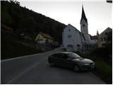
From the highway Ljubljana - Maribor we go to the exit Žalec, and then we continue driving towards Velenje. Still before Velenje, we leave the main road, because signs for Vinska Gora point us to the right on a local road, and already after a few meters it brings us to the next crossroad. Here we continue left in the direction of the church of St. John the Baptist, and we follow the ascending road to the parking lot by the already mentioned church.
Route description:
From the parking lot at the church, we continue on the asphalt road and at the crossroad, we continue left. After a few dozen meters, blazes point us to the left upwards on a narrower road. Later, the road slightly descends, and then we soon continue right into the forest. Next follows traversing on a narrow footpath through the forest, which quickly brings us to a crossing below Gonžarjeva peč. Left leads an easy path to Gonžarjeva peč, and we continue right where there is the beginning of a secured climbing path.
The climbing path is made the same way as climbing paths abroad and it is the first so demanding path in Slovenia. According to the Austrian scale, which is most often used for grading the difficulty of such climbing paths, it is graded with difficulty level D/E.
At the entrance into the climbing part of the path, we must equip ourselves with a self-belay set and a helmet; the use of climbing gloves is also recommended.
At the beginning of the climbing part, the path very steeply ascends by the steel cable and we are quickly before the most difficult part of the path. Here the path leads over smooth vertical plates, where there are very few natural holds, so we need a lot of strength in the arms.
After that, the path becomes a little less demanding and with a little easier climbing, we soon reach the logbook box, which is situated by the path. From here follows the final very steep ascent, which is graded with difficulty level D.
On the top we are then rewarded by a nice view towards Vinska Gora and surrounding hills.
We descend on an easier path, which bypasses the wall on the west side.

Photos:
 1
1 2
2 3
3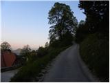 4
4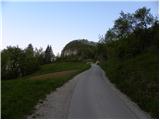 5
5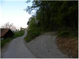 6
6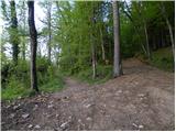 7
7 8
8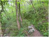 9
9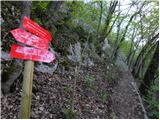 10
10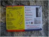 11
11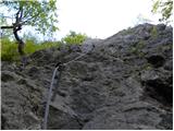 12
12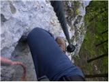 13
13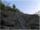 14
14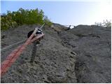 15
15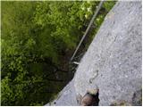 16
16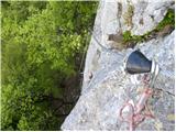 17
17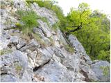 18
18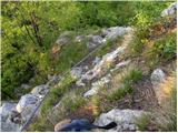 19
19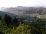 20
20 21
21 22
22 23
23 24
24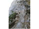 25
25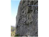 26
26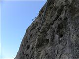 27
27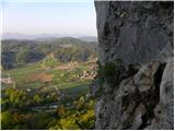 28
28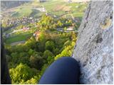 29
29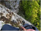 30
30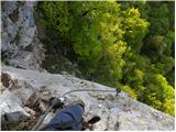 31
31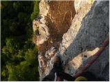 32
32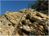 33
33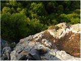 34
34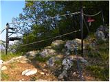 35
35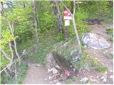 36
36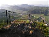 37
37 38
38
Discussion about the trip Vinska Gora - Gonžarjeva peč (climbing way)
Show older messages
|
| medo*25. 04. 2011 |
WARNING! On the climbing path - training polygon for via ferrata - to Gonžarjeva peč, the cables are quite loose and the eighth belay point according to the logbook is pulled out, a rock the size of a watermelon is held up only by the drill glue.
|
|
|
|
| penzionist25. 04. 2011 |
Well, that rock has really come loose from the wall and it's a bit uncomfortable feeling to go over it. Definitely that bolt needs replacing. Everything else (cables) is completely fine and exemplary made.
|
|
|
|
| jurakjernej12. 05. 2011 |
TODAY CLIMBED THE ROUTE. THE ROUTE IS VERY DEMANDING, THERE IS NOTHING SIMILAR IN OUR HIGHER MOUNTAINS, SO EXTREMELY CAREFUL AND STRENGTH IN HANDS, SO IT DOESN'T SURPRISE YOU.
|
|
|
|
| bandy12. 05. 2011 |
Press the Caps Lock key.... uppercase letters are really annoying! Thanks
|
|
|
|
| salvinia22. 05. 2011 |
Possibly one more piece of information missing above: above both steep sections there is an equipped belay station.
|
|
|
|
| bostjan11s30. 08. 2011 |
Yesterday I climbed the path, which is excellent, flawless and really exemplarily arranged.
But it is true that it is very demanding especially in the first part, as there are very few holds, so I almost lost the will but it was worth persevering
Without the help of the fixed cable it still wouldn't go
|
|
|
|
| nitram30. 08. 2011 |
And for such ascents do you only have a self-belay set and helmet or something else?
|
|
|
|
| geppo30. 08. 2011 |
For Gonžarjeva, in addition to the self-belay kit, helmet, gloves, a via ferrata lanyard is also needed (harness with HMS carabiner, so you can rest in the difficult section and relieve your hands.
|
|
|
|
| nitram30. 08. 2011 |
geppo thanks for the reply
|
|
|
|
| bostjan11s26. 09. 2011 |
Well, last week I learned it the hard way: without a helmet nowhere to via ferratas!
On the upper "D" section above the logbook box at the spot where you need to change the climbing side (red dot on the rock) while descending I slipped badly (made too big a step and it unbalanced me), lost balance and with (helmeted) head banged against the rock and dangled about 3m lower.
Lately I've been on this via ferrata at least 1x a week but despite "knowing the terrain" it's no guarantee that you're safe or that you can relax self-belaying.
Luckily in the end it was just some scratches on hands and half-torn identification on the self-belay set. Without a helmet it might have been different.
And my intention is not to scare anyone, Gonžarjeva peč is a super training ground, I just described my experience.
LP
|
|
|
|
| geppo26. 09. 2011 |
Yes, it really is a proper training ground for climbing difficult via ferratas. For me the upper part after the rearrangement, when that rock collapsed, is harder than the lower one.
Lp
|
|
|
|
| vanja119. 10. 2011 |
Today we tackled this ferrata.
I have to say "hats off" to the designers and builders. Shame, because with such enthusiasm nature didn't provide better conditions. Let this be a reminder and incentive for Bohinj and Kranjska Gora folks, that it can be done if you want to, even if it seems there are no basic conditions.
The route is great, as my predecessors say, realistically (especially compared to Skywalk) it could have one grade lower rating.
My motto is: ferrata on the north face across the Sphinx.
|
|
|
|
| VanSims19. 10. 2011 |
***vanja1 says:***: My motto is: ferrata on the north face across the Sphinx.
Now get ready for the avalanche!  
|
|
|
|
| gapo19. 10. 2011 |
This ferrata would be nice.
|
|
|
|
| Sam.volk19. 10. 2011 |
Vanja 1, I hope the nature destroyers won't succeed with this. Lp
|
|
|
|
| neph19. 10. 2011 |
Vanja1, if you lower the rating of Gonžarjeva peč, then you have to lower the rating of the praised ferrata in Železna Kapla too... Maybe Skywalk is underrated
|
|
|
|
| vanja119. 10. 2011 |
Maybe true. You got me excited, so I stuck a picture from the profile into the Skywalk thread too.
|
|
|
|
| Alesko197120. 10. 2011 |
Ferratas are fine, but the Sphinx is a Slovenian monument, icon, and as such untouchable Vanja, no hard feelings.
|
|
|
|
| Bojan_A20. 10. 2011 |
I hope no one is "smart" enough to route a via ferrata anywhere across the North Triglav Face.
|
|
|
|
| jurakjernej20. 10. 2011 |
When I look at your comments "nature protectors" I'm wondering with what they will destroy nature?
Look at our northern neighbors the Austrians, who exploit every corner and know how to market it unlike us, who only talk but never actually act, and if we do, negative debates ensue like now.
I'm for more via ferratas in Slovenia, because I see nothing bad in it.
|
|
|
|
| JusAvgustin20. 10. 2011 |
Well, that's your personal opinion, now let me express mine: definitely against via ferratas, I see no sense in hauling yourself across a wall on a taut cable, no sense in hanging on pegs and brackets, no sense in dragging two rookies behind you, especially no sense in pretending you're climbing while doing it... Now I'm waiting for the avalanche, the mere statement of routing a via ferrata across the Face is completely inappropriate, across Sfinga is just plain stupid and totally out of place.
But I'm convinced that if you tasted real pathless terrain, most would say goodbye to via ferratas!
|
|
|
|
| Fifi20. 10. 2011 |
via ferrata is like listening to porn on the radio
|
|
|
|
| VanSims20. 10. 2011 |
I already made the comparison once: with porn everyone jerks off, but they watch it. Same with via ferratas.
When I was at Mualverich Alto I met an Englishman living in Austria. In Britain the first via ferrata opened and there was uproar. In Austria they are everywhere and no problem. It's just about perception and mentality.
That Englishman said he has nothing against via ferratas if they help someone reach a mountain. My stance is similar. Of course via ferratas can also be abused, commercialized... like anything else.
Ah, where are the times when pornography was still natural, non-commercialized, actually still underground and not today when it's everywhere you turn!
|
|
|
|
| Nemo1320. 10. 2011 |
One classic via ferrata could be routed on the Ljubljana skyscraper, it would be accessible to all, really a bit shorter, but with the construction of taller buildings they would already be decent, and GRS would have easier work in case of rescue
|
|
|
|
| Alesko197120. 10. 2011 |
There is enough space for everyone in the mountains. It would really be silly to build via ferratas in walls like Sfinga. Just as free climbers are against via ferratas, the "ferratists" would be against concrete stairs. If some pure layman reads this, he might think via ferratas are completely undemanding and pull you up by themselves. For ordinary mortals it's an approximation to climbing and adrenaline. Not all of us will free climb Sfinga. But a good business could be made - we have enough space.
|
|
|
|
| vanja120. 10. 2011 |
This goes out to the anti-via ferrata crowd.
Mountains belong to everyone; if we can't all free climb them, aids are available to us.
The same applies to disabled people. By your logic, they have no business in the city if they can't get over the curb with a wheelchair.
And yes, in this case I am disabled and feel threatened while also being appalled by possessives. So uninstall your sphinx and install it in the living room.
|
|
|
|
| JusAvgustin20. 10. 2011 |
vanja1, this one's for you, your comparison should be labeled as the dumbest so far on hribi.net, no hard feelings!
|
|
|
|
| turbo20. 10. 2011 |
I mean 
...
park the vehicle 50m from the crag, climb a 120m bolt-equipped wall, there some 7 or 8 ...
and compare
Skalaško with aid, possibly even with the approach to the top of the pinnacle
...
or go via Rekarjeva to Vrbanove, not to mention Amalia to Montaž
and compare that
with Gonžarjeva peč
...
well, maybe someone really does need some aid
|
|
|
|
| otiv20. 10. 2011 |
I think we have quite appropriately secured paths in our mountains; people are just too "spoiled". After all, you go where you feel safe for the ascent and the descent too.
|
|
|
|
| Loni20. 10. 2011 |
If we can't free climb them, let's stay in the valley. And one more thing, mountains aren't our property; they are natural and often cultural heritage where we can enjoy ourselves, but we don't own them. What would be left of Triglav if everyone who goes up took a stone as a souvenir.
|
|
|
|
| VanSims20. 10. 2011 |
****Loni said:*** What would be left of Triglav if everyone who goes up took a stone as a souvenir.
What the hell does that have to do with via ferratas?
|
|
|
|
| Nemo1320. 10. 2011 |
We'd all love to stand on top of Mont Everest, so we're waiting for the via ferrata
|
|
|
|
| Loni20. 10. 2011 |
VanSims, it was aimed at the idea that mountains are our property, not at via ferratas.
|
|
|
|
| vanja120. 10. 2011 |
Free climbers, you are a super race.
I acknowledge your supremacy on rock and withdraw from this fruitless debate.
The wiser one gives up, that's why the world is ruled by ....
|
|
|
|
| Keko20. 10. 2011 |
I'm not quite clear how some of you (especially alpinists) can be so vehemently against via ferratas while also citing the inviolability of nature. Alpinists also seriously damage nature by drilling holes in the rock to install various protections, anchors, and other aids. Crowds of hikers everywhere in the mountains also cause a lot of damage. If someone doesn't see the point in pulling on pegs and pitons, that's fine too, but surely many others find it pure pleasure. People are different, and that difference must be respected. If we're honest, all of us who head into the mountains, regardless of the method, more or less equally destroy this alpine world. If we want to protect the alpine world, we'd have to ground all alpinists, hikers, ski tourers, via ferrata climbers, paragliders, and others below 1000 meters.
A via ferrata through Triglav's north face. Why not. The first ones to crudely intervene in it with holes and their drills were alpinists. That's why I believe mountains should be accessible to everyone within reasonable limits, or to no one. When the last human disappears from the face of the earth, the mountains will still exist, no matter how much we argue about what belongs there and what doesn't.
|
|
|
|
| Loni21. 10. 2011 |
Well, I'm not an alpinist (at least not by training) and I happily tackle via ferratas too, no mistake about that, but I don't own the mountain either. And if it's right under my nose, a via ferrata of course, I'll go climb it (at least try).
Keko, I happily sign under your last sentence.
|
|
|
|
| jurakjernej21. 10. 2011 |
Via ferrata across the north Triglav face-crossing from Aljažev dom towards Luknja.
3 km of adrenaline enjoyment along a taut cable above the mighty precipices of the north Triglav face. If this weren't an attraction that would attract Austrians and Italians in greater numbers to our mountains. This will be my proposal to PZS.
|
|
|
|
| jurakjernej21. 10. 2011 |
The most beautiful possible ferrata that could be built here would be a vertical ascent to Bled Castle, which would certainly reach difficulty E.
|
|
|
|
| Alesko197121. 10. 2011 |
Every mountain has multiple approaches for all kinds of mountaineers. You can still go to Begunjščica from Završnica via Smokuški "mev". A really nice pathless terrain, great for building fitness - and you don't meet a living soul. Triglav is anyway a pilgrimage procession for a long time. With ferrata or without... Anyway, ferrata doesn't fit on Sfinga, I agree with the Bled idea - but given that Bled is more touristy, nothing will happen - or it will take another 100 years.
|
|
|
|
| geppo21. 10. 2011 |
Keko
alpinists have their own sites where they post.
Hardly any of them would descend to such a level of communication... as you find here!
LP
|
|
|
|
| lola21. 10. 2011 |
Hello,
I'm interested if this path is much harder than Furlanova pot (Gradiška tura above Vipava). Well, from the pictures it looks more demanding, but still an opinion would be welcome.
Thanks and lp
|
|
|
|
| Keko21. 10. 2011 |
This path is a couple of classes harder than Furlanova, but quite short. It is by far the hardest secured path in Slovenia. In the book 55 Secured Climbing Paths by Mašer, it is rated with the highest difficulty PP6. The same rating has only the climbing path in Železna Kapla, but even that is somewhat easier in my subjective opinion, but longer. Furlanova pot has rating PP3/4.
|
|
|
|
| lola21. 10. 2011 |
Keko, thanks! Then I'll have to train somewhere else...
|
|
|
|
| geppo21. 10. 2011 |
Yes, really train, because Gonžarica is a tough nut and there is no such demanding path anywhere in Slovenia!!
The recipe is Lawamünd. Try to climb this ferrata without using the brackets, and you'll see where you stand...
LP
|
|
|
|
| lola22. 10. 2011 |
Geppo thanks for the advice. I'll try Lawamünd. Is there perhaps something similar in Slo? thanks and lp
|
|
|
|
| Keko22. 10. 2011 |
There are no similar trails in Slovenia. Maybe we scared you a bit too much. If you're in good physical condition and quite strong in your arms you have almost nothing to fear. I know some completely average people who managed to climb it, including women. If you know someone who is more experienced in climbing and belaying with a rope, they can belay you from above with a rope, as there are also prepared belay stations on the trail for that purpose. If it's just too much, a small pull with the rope helps a lot and it will go.
LP
|
|
|
|
| DarjaZaplotnik22. 10. 2011 |
Wrote by @Keko...I know some completely average people who managed to climb it, including women...
OK, I won't comment on your nonsense about alpinists, @geppo has already written what and how.
But the quote above is one hell of a chauvinistic statement!!!
Even the via ferrata over Sfinge hides from it.
lp d
|
|
|
|
| Keko23. 10. 2011 |
I see that I wrote it clumsily. This was meant with additional belaying under the watchful eye of an experienced mountaineer and also somewhat with additional help and by no means in a solo action so as not to mislead anyone.
LP
|
|
|
|
| JusAvgustin23. 10. 2011 |
nonsense is popular this year...you would be surprised how many alpinists there are up here...
|
|
|
|
| garmin23. 10. 2011 |
The tour is proven suitable also for some women.
|
|
|
|
| keber123. 10. 2011 |
Probably it's also suitable (only) for some men.
|
|
|
|
| žuti24. 10. 2011 |
This reading amuses me a bit: of course the lady didn't seriously mean a via ferrata across the Triglav wall, but I liked the debate that ignited afterwards: In my younger years I was an alpinist, now I somehow satisfy my ambition in via ferratas! The decision of the umbrella mountaineering organization that no new secured paths are to be built in the high mountains is completely correct!!! However, the development of this method of overcoming walls continues and I think it would be good to build some new via ferratas in the valleys, but above all not at the expense of destroying old alpinistic routes (Cjajnik). I also don't particularly like all that iron in the wall, but I still use via ferratas: of course I get in the car and go to the other side of the Karavanke! Tourist places would especially enrich their tourist offer with lowland via ferratas: for example, I mention sleepy Mojstrana, which just can't wake up from tourist lethargy! Before World War II, it was far ahead of Kranjska Gora in accommodations! Above Mojstrana rises a beautiful wall that just begs for a new via ferrata!!!
|
|
|
|
| garmin24. 10. 2011 |
Of course, those who will never climb over Sfinga oppose via ferratas there. And that rope wouldn't bother them. On the other hand, hanging on ropes is ridiculous, just as it's ridiculous to consider oneself a ferratist.
|
|
|
|
| VanSims24. 10. 2011 |
***garmin said:***:Of course, those who will never climb over Sfinga oppose via ferratas there.
Oh, but they will climb it, don't worry.
According to the neighbor's story, in our building about 20 years ago, when they were laying cable TV, many residents opposed it so much that they barely got the required majority for installation. Well, then almost the whole block ordered it.
|
|
|
|
| geppo24. 10. 2011 |
I consider discussions about via ferratas in the North Face senseless.
If you scroll up with the slider, you'll notice that this is about Gonžarjeva peč...
best regards
|
|
|
|
| IztokMeglic10. 03. 2012 |
JušAvguštin: regarding what you wrote about via ferratas, remember how proud you were when you climbed Hanzova and Kopiščarjeva paths on Prisank 3 years ago. But back then it wasn't destroyed nature. Regarding the Triglav via ferrata, I think it doesn't really belong there but they could make more via ferratas in Slovenia following the Austrian example.
|
|
|
|
| skalaš7030. 05. 2012 |
Well said IztokM.!
Best regards and stay safe up there
|
|
|
|
| SilvestrO31. 05. 2012 |
Opponents and supporters..., principled, always on the same side...
.
|
|
|
|
| andrej782. 06. 2012 |
IztokMeglič,skalaš70, do you two even know who Juš Avgustin is (better look at his photos and blog), and the via ferrata over Sfingo etc... has it really deteriorated? I haven't been up here for some time and can't believe what you're writing!
|
|
|
|
| panda2. 06. 2012 |
And where's the end to this? Whoever doesn't like via ferratas shouldn't climb them, whoever likes them should climb rather than write nonsense and possibly offend others. I've tried the Cjajnik via ferrata, and the Italiano one, but Gonžarjeva doesn't appeal to me. End. But I'd try the one over Sfingo! Why not? Why not have the highest via ferrata in Slovenia? I'm for it.
|
|
|
|
| slavi09022. 06. 2012 |
I'm really amused reading the comments.... let me say that I too love via ferratas, because without them I would never be so close to the walls... and let me also say that my husband was once a mountaineer, today he gladly climbs or secures a via ferrata with me, just to give me advice and of course to watch over me,... I wish you a nice evening
|
|
|
|
| rexkex1238. 06. 2012 |
Super via ferrata, really enjoyed it! Great addition for local hikers and alpinists!!!
|
|
|
|
| milepetro28. 06. 2012 |
On Saturday I'm going to try it too, to see what this via ferrata on Gonžarjeva peč is like.
Greetings and lots of good mood in the mountains, on via ferratas or wherever you are in nature
|
|
|
|
| milepetro28. 06. 2012 |
I forgot something else. Can someone tell me (write) how crowded it is on Gonžarjeva peč on weekends.
Thanks in advance for the reply.
|
|
|
|
| pohodni28. 06. 2012 |
I was there last fall and this spring, both times Sunday morning, not a living soul anywhere, though it's probably not always like that.
Be early, as it'll be very hot in the wall.
Regards.
|
|
|
|
| remolog5. 09. 2012 |
I won't get into debates .. whether these are via ferratas or not, because I used to oppose them to death, today years and weight carry me on these paths. But something interests me, if anyone knows: comparison of difficulty ratings?!? Since I've already done a E difficulty ferrata (and it was quite hard) and I've done (not saying climbed to offend anyone) PP6, I'm curious what rating the Via Italiana ferrata on Mangart had? C,D,...?!? Can it even be compared to modern sports ferratas. I'm asking because I'd like to take a couple to some sports ferrata, they have Via Italiana as the hardest behind them, but I don't want us to get stuck somewhere. Especially since I've a bit forgotten the technique of lowering and raising a fallen person (but I haven't forgotten how hard it is). Thanks for advice and answers!
|
|
|
|
| andrej785. 09. 2012 |
Italiana is C, in some places also D.
|
|
|
|
| urbancek5. 09. 2012 |
My personal opinion is that Italiana is at most C...
|
|
|
|
| turbo5. 09. 2012 |
As if we were talking, or writing, about shells and fish
Gonžarjeva peč - you drive almost to the start and descend in sneakers. Apart from the self-belay set, helmet and gloves, you need nothing else.
Mangart, Via Italiana - approach, either downhill from the saddle or uphill from the valley, there's definitely some anyway and then ascent to the summit, definitely with all necessary gear for possible weather change and everything needed for high mountains.
Difference at least like between a noble slow food restaurant and a kebab kiosk.
|
|
|
|
| dprapr5. 09. 2012 |
Via Italiana really can't be more than C difficulty. For it we don't need any special strength, rather the ability to move on a steep wall. And even that offers intermediate rests.
Apart from the short summit part that "smells" like ferrata, it's more similar to our secured paths.
But I agree that high mountain paths shouldn't be compared to lowland paths - even if we drive high up.
|
|
|
|
| remolog5. 09. 2012 |
Thanks for the comments or rather information! I agree with not comparing sports via ferratas with great classics, but I was only referring to the explicitly technical part. What all can happen to you on a high mountain tour or on a training ground, I've (unfortunately) experienced a few times myself. Thanks again for the information, I'll go check out this Gonžarca on Friday before work, I simply have too many sweaty fingertips not to go!
Cheers to all
|
|
|
|
| milesdavis5. 09. 2012 |
I've climbed a lot of via ferratas already, all in hiking boots. But on Gonžarca, at the beginning where it's hardest (D/E), I slipped, my hiking boots slid because there are no footholds. For me, it's technically 2 grades harder than V.I. Now I need to get more climbing shoes and wait for the wounds to heal (now I'll take gloves with full fingers) and try again. Cheers
|
|
|
|
| andrej785. 09. 2012 |
Dprapr, a bit more and Italiana will be like going to Mojstrovka, come on, sober up a bit. Read what Italiana means in our and neighboring mountains and check the difficulty specification too, you absolutely cannot compare it to our very demanding paths that seek natural passages and avoid exposure. Sometimes it seems to me that some of you write just anything off the top of your head!
|
|
|
|
| Keko5. 09. 2012 |
Several people have already wiped out on Gonžarca. I've come across it a few times that some take it too lightly and then burn out on the whole line. Although it's short, it needs to be taken very seriously. Even though I've climbed it several times, I still approach it with respect. Its technical difficulty is at an enviable level, since along its entire length there isn't a single peg or bolt. In Mašera's book 55 Climbing Routes, it's placed alongside the via ferrata in Železna Kapla at the top of difficulty among the described routes in that book. However, in Železna Kapla the hardest part, in my opinion, is not as technically demanding as on Gonžarca.
|
|
|
|
| urbancek6. 09. 2012 |
@andrej78: Via Italiana (with all due respect to that route) however in terms of difficulty is nothing special and is exactly what dprapr described. I also agree with turb's note... Don't reinvent the wheel where there isn't one!
P.S: Does Via Italiana not seek natural passages anywhere at all?
|
|
|
|
| pohodni6. 09. 2012 |
The climbing Via Italiana on Mangart and the Gonžarjeva peč via ferrata in Vinska Gora cannot be compared in technical terms at all. My wife burned out on Gonžarjeva after just the first five meters, while she climbed Via Italiana with ease. Definitely, Italiana is closer to Hanzova on Mala Mojstrovka than to Gonžarjeva, which is in a class of its own at least with us. It is true though that Gonžarjeva is very short but burning. If you're fit enough, you're up very quickly, otherwise you can only watch it from below.
|
|
|
|
| Kita7. 09. 2012 |
Fit enough??? Where do these trainings even exist???
And stop comparing hiking paths (Via Italiana)... with sports via ferratas (Gonžarjeva peč)... Via Italiana reaches grade C... Some read too much and climb too little...
|
|
|
|
| Kita7. 09. 2012 |
Gonžarjeva peč is short but what if a 4 times longer and similarly technically demanding via ferrata comes... hands don't hold up to everything!!!
|
|
|
|
| Alesko19717. 09. 2012 |
Anyone who has never been in the high mountains but has strength in their arms will probably climb Gonžarca. But it's not certain that they will then manage to reach Begunjščica. I myself climbed the so-called Superferata on Dachstein (Anna + Johan), but on Gonžarca I didn't succeed on the first try... I just want to say that comparisons of Gonžarjeva peč with high mountains are NONSENSE.
|
|
|
|
| urbancek7. 09. 2012 |
Kita, primoza and Alesko1971: You have my signature too.
|
|
|
|
| dprapr7. 09. 2012 |
If on a via ferrata we use "only hands, legs are for decoration", then the length of the via ferrata can be a problem.
Well-designed are those via ferratas that have one of the harder sections right at the beginning, like for example Johan on Dachstein, and thus have a built-in safety valve.
|
|
|
|
| Keko7. 09. 2012 |
If the via ferrata is longer and its difficulty is consistently at a high level throughout, you also need to adapt the technique accordingly. On Gonžarjeva peč I have never used the via ferrata set for rest. When we were overcoming a few weeks ago what until recently was the hardest via ferrata in Austria above Kristall Weisssee lake in the Hohe Tauern, rated E in some guidebooks even E/F, we all hung a lot on the via ferrata set and I can hardly imagine progressing without it. Already in the initial crossing the wall is overhanging, the cable is loose, so you're constantly hanging far back on your arms and your strength quickly starts to run out. Just with raw strength and without the via ferrata set for rest, I wouldn't have gotten far on this one. If you tackle such via ferratas in a smart way and with the help of various techniques, you can progress nicely and there's no need to be exhausted from effort. Knowledge from sport or alpinistic climbing is also very useful.
More impressions and photos from this via ferrata: http://atv.hamradio.si/photo_album/Climbing_and_Mountaineering/Kristall_Weisssee_12.08.2012/index.html
|
|
|
|
| panda8. 09. 2012 |
Keko: well, believe it. Hats off to all women for what they endured......
|
|
|
|
| Keko8. 09. 2012 |
Yes, I too was surprised by what women can achieve. On this via ferrata they didn't lag behind the men at all. Sometimes it's really clear that men do many things with brute force and tire faster, while women use more refined grips and are just as successful. It is true that it was a group of experienced via ferrata climbers who know how to handle things.
|
|
|
|
| facko8. 09. 2012 |
Keko already knows how to handle things: probably you all / you all went through his "school" regarding secured climbing
And a bit joking a bit seriously: the participants managed all difficulties because: 1) they left some character at home and it was easier then 2) they were in a group and had no public comments 3) they have practice
Too bad they have their "center" in Velenje; if it were closer I'd join them (of course - if I passed the "entrance exam"  in their "school") in their "school")
Best regards
|
|
|
|
| Keko8. 09. 2012 |
To avoid misunderstanding, I was among the less experienced via ferrata climbers.
|
|
|
|
| Kita8. 09. 2012 |
I somehow missed seeing that Milan posted about Kristall otherwise I should have been there then... It really slipped past me... Too bad but it'll wait....
|
|
|
|
| slavi09028. 09. 2012 |
@Keko......all honour to you, hats off
|
|
|
|
| igor k15. 09. 2012 |
Today I climbed this via ferrata. I've already been to Železna kapla several times, and this one on Vinska Gora pleasantly surprised me, especially the last part at the bush which I went around on the right side!!!
|
|
|
|
| grega_p26. 09. 2012 |
I've already climbed many difficult vias ferratas (Železno kaplo, Clap Varmost, Cjajnik, Tofano, Italiano...), but I feel that at a certain point on Gonžarjeva it squeezed me the most. The initial part not so much, but up there, where I'd give a slightly higher grade due to lack of footholds. It's true it's short and doesn't tire you as much as the others..
Overall very well secured, but the rock is crumbly, so be careful when gripping anything other than the cable. And better not with hiking boots on wet rock!
|
|
|
|
| igor k26. 09. 2012 |
I completely agree with you grega p! it was great
|
|
|
|
| andrej7827. 09. 2012 |
Again, we're comparing via ferratas and Via Ferratas! Do you have 800 meters under your butt on Vinska Gora? Don't mix apples and coconuts..!
|
|
|
|
| grega_p27. 09. 2012 |
Andrej, from my side it was meant in terms of difficulty, the feeling of exposure is a purely personal matter that can add or subtract a lot to the psyche... Probably for the butt it's the same whether there are 60 or 600m
Good luck!
|
|
|
|
| pinny2. 10. 2012 |
Yesterday exactly the 7th time climbed this rock wonder , this time 2x in a row, because once is really little . Otherwise when I was up the 1st time I said to myself in the middle of the first ascent damn this is tough, because in this part there's hardly anywhere to push with feet, in one part not at all, so only arms work, and also in the upper part there's a section where only arms work. But it wasn't just the first time, so now Gonžarjeva peč is for me for training . Is there maybe someone here who also goes elsewhere to via ferratas? E.g. I saw Božičev vrh in Železna Kapla and it's tough. If someone goes somewhere like that, I recommend myself
|
|
|
|
| pohodni2. 10. 2012 |
I also managed to climb it 3x in a row in both directions recently. Since time was pressing me a bit, I did the whole thing in an hour and a half. Although it wasn't hot, sweat was dripping properly from under the helmet from the effort. For strengthening arm muscles this Gonžarica is really the right thing.
But at least in my opinion it's one grade harder than the one in Železna Kapla. However, we know that every eye sees differently.
|
|
|
|
| urbancek2. 10. 2012 |
I didn't know that such via ferratas are also descended:rollingeyes:
|
|
|
|
| pohodni3. 10. 2012 |
Why not? That day the via ferrata was completely empty and I could train in both directions as I pleased. It doesn't hurt if you know how to descend the via ferrata too. If, for example, you climb to Cjajnik, you're facing a not exactly easy descent down along the cable in any case. Apparently, excess never hurts the head.
|
|
|
|
| urbancek3. 10. 2012 |
If you climb to Cjajnik you can descend via that "western" variant, where you avoid a considerable part of the cables
I have nothing against it, it just seemed strange to me. Regards!
|
|
|
|
| pinny5. 10. 2012 |
I also climbed Gonžarjeva peč up and down 3 times two days ago
|
|
|
|
| Kita21. 10. 2012 |
Gonžarjeva peč is a typical example of a modern sports via ferrata, where there are no steel cables or other artificial aids and it is certainly the most technically demanding climbing path among us, the hardest part in Železni kaplji is long but those few pegs greatly facilitate the passage. Many people rank Via Italiano on Mangart and Kopiščarjevo on Prisojnik in this category, but those paths are far from sports via ferratas...andrej78 you don't need 800m under your ass, if you fly out of the first wall in Gonžarjeva peč it's enough, it's only about 20m...
|
|
|
|
| pinny26. 03. 2014 |
Are you climbing already or not yet?
I last year at the end of December, this year first 2x and second 3x, about two weeks ago
|
|
|
|
| traceour28. 03. 2014 |
Is there still any snow in those areas or is it clear?
|
|
|
|
| Jonny_28. 03. 2014 |
AHAHAHA! You're really showing them!
|
|
|
|
| skalaš7028. 03. 2014 |
Last week for good training on home terrain 5x in one hour and fifty-five, next three days as reward orng "muskelfibr".
|
|
|
|
| klemen7323. 08. 2015 |
skalaš70
or did you go the normal path 5x, because ferrata 5x in this time?????????
|
|
|
|
| don kihott23. 08. 2015 |
If you climb it down even along the wall you are 5 times up and down in a good hour...
|
|
|
|
| klemen7324. 08. 2015 |
Ugh, I'm an idiot. It only goes down.
|
|
|
|
| SabinaM2. 04. 2016 |
Today car keys (Volkswagen) were found under the via ferrata. We hung them on the board at the entrance.
|
|
|
|
| fico19. 10. 2016 |
Is anything happening at Gonžarca? I haven't been up there this year yet, but I plan to go at the beginning of November if the weather holds. This year I had bad luck on all via ferratas alone, only on Lisca did I meet some fellow hikers.
|
|
|
|
| don kihott21. 10. 2016 |
I'll sign up as a companion
|
|
|
|
| fico31. 10. 2016 |
Today at Gonžar sunny weather, quite warm and dry, ideal for climbing. Finally once not alone on the wall. Primož last Saturday even in a family rope team.
|
|
|
|
| don kihott2. 11. 2016 |
Basically you climbed it and even had company
|
|
|
|
| barbara.hribi17. 08. 2017 |
On the holiday morning itself (15.8.) "with mine" we managed to do Gonžarjeva peč. Uff, yeah - short and toughhh! At least for me in the first third. When you really need quite some strength in your arms, which for me - office mouse - is not easy. And even though getting to Lisco is a small cough for me, and to Češka koča b.p., this was quite strenuous for me. But the satisfaction is all the greater when you reach the top... When you really need quite some strength in your arms, which for me - office mouse - is not easy. And even though getting to Lisco is a small cough for me, and to Češka koča b.p., this was quite strenuous for me. But the satisfaction is all the greater when you reach the top...
|
|
|
|
| fico23. 10. 2017 |
Barbara, if you use your legs you'll relieve your hands, but you need proper footwear so you don't slip, of course you had no trouble with Lisca because there are pegs there, try Lisca once without using pegs and bolts, only using the wire rope, and you'll see that Lisca isn't so easy either.
|
|
|
|
| don kihott26. 10. 2017 |
Barbara isn't it interesting Češka has E rating, Lisca D/E and in the end you realize Gonžarca is almost a full grade harder than both...hmmm???
|
|
|
|
| daver9. 05. 2018 |
This year I went to Gonžarjeva peč for the first time. I have to say, it's top for me personally. Too short, but sweet
I recommend it. I myself go there about 2x a week...
|
|
|
|
| don kihott11. 05. 2018 |
Gonžarjeva is a real deal...It has a real D/E section that is not made up like on Lisca!!!
|
|
|
|
| daver13. 05. 2018 |
Endorsing Don Quixote's post. Don't take it lightly or for granted...
|
|
|
|
| BubikolRamios19. 02. 2020 |
The thing is; it has 3 sections (first and last are difficult, middle is more or less a walk), the most difficult part (if you don't know exactly how to move in via ferratas) is the last 'pitch' of the first, going back down from there isn't too smart because the rock is quite crumbly.
The so-called D/E in the last part is in my opinion equal to the last pitch of the first part, just maybe 1-2 m longer.
The fixed ropes are placed so that they automatically pull you to the precipitous side.
Harder than Jerman/Gozd Martuljek - there are pegs. If there weren't, the rating would be reversed.
|
|
|
|
| don kihott21. 02. 2020 |
The D/E rating on the exit wall of the via ferrata on Gonžarjeva peč is fair only if climbed on the left side of the cable on the slab without stepping on the stretch pegs or pushing into the hole behind the cable...
|
|
|
|
| AAvrikelj24. 09. 2020 |
It should be emphasized that in Gonžarjeva the cables are intentionally not tensioned, as they are on Otmarjeva in Gradiška Tura, where WITHOUT USE OF HANDHOLDS the rating even reaches D/E, except in the initial overhang where the rating is even higher.
|
|
|
|
| don kihott7. 11. 2020 |
Avrikelj, don't talk nonsense...
|
|
|
|
| kaplan19. 08. 2022 09:53:08 |
At 54 I climbed it quite well. But I don't recommend it at +32 degrees, like I had yesterday. Harder than Jermanca.
|
|
|
|
| don kihott21. 08. 2022 11:43:57 |
Yeah, normally, a via ferrata without pegs in the wall is significantly harder than one where pegs are crammed in every half meter and you feel like you're climbing a ladder rather than the wall... Gonžar deserves a D/E rating, Jerman max C/D...
|
|
|
To post a comment you must log in:
If you do not yet have a username, you must first
register.