Vranček - Planina Korošica
Starting point: Vranček (950 m)
| Latitude/Longitude: | 46,42790°N 14,27260°E |
| |
Walking time: 1 h 35 min
Difficulty: easy marked way
Elevation gain: 604 m
Elevation difference along the route: 604 m
Map: Karavanke - osrednji del 1:50.000
Recommended equipment (summer):
Recommended equipment (winter): ice axe, crampons
Views: 87.746
 | 5 people like this post |
Access to starting point:
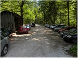
From the Ljubljana–Jesenice highway, take the Ljubelj exit and follow the road towards the border crossing. When we leave the last tunnel (we recognise it by the fact that after the tunnel on the left side of the road there is scree), in the first sharp left turn we will notice a road hut and next to it a macadam road. Here we park on a smaller parking lot or we drive further on a worse road to the next parking lot, which is situated a little higher.
Route description:
From the parking lot, we head onto a bad forest road and follow it further. The road higher crosses a torrent bed, then slightly ascends and brings us to the spot where it ends. Ahead we cross the bridge and continue on the cart track, which moderately ascends partly overgrown scree. The cart track makes a few sharp turns and brings us from the northern slopes of Košuta to the southern slopes of Košutica.
Further, we mostly ascend through the forest, which brings us to a larger clearing. Here the cart track turns sharply left and ascends towards the mountain pasture Korošica. A little before the mountain pasture we cross a grazing fence, where a beautiful view opens up. From the meadow we go slightly right below the cottage, which we see above us. The path then turns left and in a few steps of ascent brings us to the cottage on the mountain pasture Korošica.
Photos:
 1
1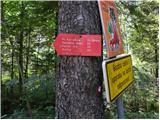 2
2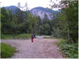 3
3 4
4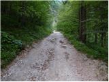 5
5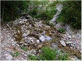 6
6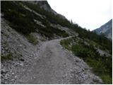 7
7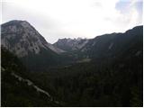 8
8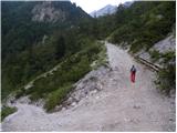 9
9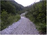 10
10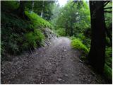 11
11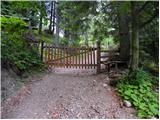 12
12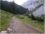 13
13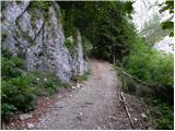 14
14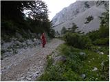 15
15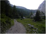 16
16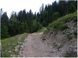 17
17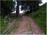 18
18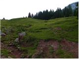 19
19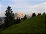 20
20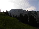 21
21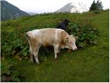 22
22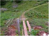 23
23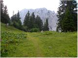 24
24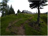 25
25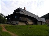 26
26
Discussion about the trip Vranček - Planina Korošica
|
| Gost8. 07. 2006 |
A mountain pasture as they used to be. Without cars, with good mountain food, friendly caretakers. Beautiful nature, peace, flowers....
|
|
|
|
| Gost3. 03. 2007 |
Even in the mountains, the presence of modernized hikers is increasingly felt, who rush only for stamps to the summit and back to the valley, only a few feel the peace of nature.
|
|
|
|
| Gost2. 05. 2007 |
Really very friendly hut keeper. Nature wonderful, coffee good and not overpriced. Rating 10 marija
|
|
|
|
| Gost2. 05. 2007 |
Marija, where is the better coffee, on Korošica or on Javornik?
|
|
|
|
| Gost2. 05. 2007 |
On Javornik I got it with cream, Marija
|
|
|
|
| Gost3. 05. 2007 |
Oh, Marija, I still feel the consequences from Dobrča. The path to Korošica really stands me straight up. How steep the path is, oh Marija! But I realized that a steep climb I handle better than flat terrain. I visited the planina before this year's opening, so I don't know about the host. But I believe that in such a beautiful, friendly and peaceful corner there can't be negative bad energy. The spirit of the fighter is always calm!
|
|
|
|
| Gost6. 05. 2007 |
Why do you delete only some comments?
|
|
|
|
| Tadej6. 05. 2007 |
We delete comments that don't belong in the discussion. Guest no.6 explained (in layman's terms) his ascent to the mountain pasture. Guest no.7 (comment that was deleted) didn't understand him and wrote it in an impolite way. Best regards.
|
|
|
|
| bazo16. 05. 2007 |
Very nice nature and excursion!
|
|
|
|
| Gost12. 06. 2007 |
Nice and peaceful, with wonderful views. Just don't get caught by bad weather....
|
|
|
|
| Gost1. 07. 2007 |
Here it is really the most most most beautiful. marija
|
|
|
|
| popek29. 07. 2007 |
 For those with average fitness, the ascent draaaags on looooong, but in the end it's outweighed by the magnificent nature, very friendly hut keepers, HOMEMADE SOUR MILK For those with average fitness, the ascent draaaags on looooong, but in the end it's outweighed by the magnificent nature, very friendly hut keepers, HOMEMADE SOUR MILK
WITH BUCKWHEAT PORRIDGE. Wonderful trip where petrol fumes and 'racing'
hikers haven't arrived yet. I RECOMMEND THE TRIP!!!
Save some strength for the descent!!!
|
|
|
|
| Gost28. 12. 2007 |
Is the hut open now in winter?
|
|
|
|
| Gost28. 12. 2007 |
Since it's a mountain pasture hut in summer, I assume it's not open in winter. If I'm wrong, I'd be happy, as it would be great to have a warm hut here in winter.
|
|
|
|
| DADA30. 04. 2010 |
DOES ANYONE KNOW IF THE HUT ON KOROŠICA IS OPEN TOMORROW MAY 1ST?
|
|
|
|
| Kriška30. 04. 2010 |
As far as I know, the alpine huts open when they bring the cows up there. That's usually mid-June.
|
|
|
|
| plavžar10. 06. 2010 |
Does anyone perhaps know the date when the hut on Korošica will open
|
|
|
|
| velkavrh27. 04. 2011 |
We just returned from the hike to Korošica. Really pleasant path. We walked it with our golden retriever in one hour and fifteen minutes. Today there are hardly any visitors. Up there were only three mountain bikers-equipped like Martians. I really like the shepherd's hut because it reminds me of past times. During the grazing season it must be very pleasant here. From here you can then go to Kofce. Highly recommended! I was here last many years ago, so it was like the first time.
|
|
|
|
| hills27. 04. 2011 |
wonderful in this area...
|
|
|
|
| AdryBK14. 05. 2012 |
Does anyone know if the hut on Korošica is perhaps already open?
|
|
|
|
| velkavrh14. 05. 2012 |
The hut or alpine dairy is open only during the summer grazing season and is privately owned. When they bring the cattle, they will gladly serve you homemade dishes from sour milk to spirits with cracklings.
|
|
|
|
| velkavrh14. 05. 2012 |
The hut or alpine dairy is open only during the summer grazing season and is privately owned. When they bring the cattle, they will gladly serve you homemade dishes from sour milk to spirits with cracklings. You'll have to wait another month.
|
|
|
|
| AdryBK8. 06. 2012 |
Is the hut at Korošica already open now, or only end of June?
|
|
|
|
| samoa8. 06. 2012 |
Hut is already open, checked yesterday.
|
|
|
|
| AdryBK8. 06. 2012 |
Thanksanything tasty to eat ? ?
|
|
|
|
| samoa8. 06. 2012 |
Well, how to put it, noooo, hm, we were more on liquids
|
|
|
|
| mgrego2217. 06. 2012 |
To me, the circular route is very nice, namely from Ljubelj to the hut above Ljubelj. From there onwards, the path to Korošica is very interesting. First a quite pleasant ascent and the peculiarity "lojtrica", then pleasant walking. You can also turn just before Korošica and make an ascent to Baba as well.
|
|
|
|
| trilko22. 09. 2012 |
The path from Vranček to the start of the alpine pasture is, to put it mildly, completely destroyed. Massacred. I don't know if they drove tanks up there for logging, but it looks really horrible - all churned up to the knees and muddy to the ears 
|
|
|
|
| olgam3. 08. 2015 |
Regarding the last entered comment, which is really a bit old, I'm asking if anyone knows how the path to Planina Korošica from Vranček is now? Is it still torn up? How are the markers?
From the path description I can't tell if the path is too steep, but it's mentioned in some comments. So what is it like? Would it be okay with slightly problematic knees?
If not, can someone suggest another path?
Thanks!
Best, Olga
|
|
|
|
| pikica13. 08. 2015 |
Taking this road up is so boring. The path via the hunting trail is nice and soft. The path is nicely gradually led through the forest. I always take it, both up and down. Here's a link with a path description http://www.hribi.net/izlet/koncentracijsko_taborisce_planina_korosica_lovska_pot/11/71/2636
The path is not marked, but at key points it's signposted with signs "hunting path". Already high in the forest a huge cairn greets you When you come out of the forest onto the pasture, then it's just a walk, almost flat to the hut.
|
|
|
To post a comment you must log in:
If you do not yet have a username, you must first
register.