Vršič - Jalovec (via Jalovška škrbina)
Starting point: Vršič (1611 m)
| Latitude/Longitude: | 46,43360°N 13,74350°E |
| |
Route name: via Jalovška škrbina
Walking time: 5 h 55 min
Difficulty: very difficult marked way
Elevation gain: 1034 m
Elevation difference along the route: 1350 m
Map: TNP 1:50.000
Recommended equipment (summer): helmet
Recommended equipment (winter): helmet, ice axe, crampons
Views: 95.730
 | 16 people like this post |
Access to starting point:
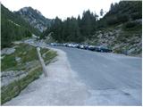
From Kranjska Gora we drive towards Bovec or vice versa, but only to the Vršič pass, where we park.
Route description:
From the parking lot at the Vršič pass we head in the direction of Trenta, where we quickly arrive at a small intersection, where a road closed to public traffic branches off to the left towards the nearby Tičarjev dom and which leads further to the Poštarski dom, but we go right, where next to the wooden cabin where they sell various souvenirs we notice the start of the marked path that leads towards Jalovec and Zavetišče pod Špičkom.
The path already after a few steps brings us to the foot of the scree under Mala Mojstrovka, we keep slightly to the left, where the path through a belt of dwarf pines leads us to the foot of the cliffs, along which we descend a bit. In the continuation the path is still quite scenic and brings us in a few shorter ascents and descents to a shorter, steeper part, where safety cables help us at two more difficult places, which come in handy when the path is wet or slippery. After the mentioned part the path gradually begins to descend transversely, and we descend for quite some time, so we get the feeling that the path will lead us into the valley and not into the area around Jalovec. During the crossing we occasionally have a nice view of the mountains above the Trenta valley, when the path returns to the forest we arrive at a marked junction near the hunting lodge in Rutarska Trenta, which is set a bit off the marked path.
We continue right in the direction of Jalovec (left downhill Zadnja Trenta, straight Zavetišče pod Špičkom) along the path that ascends relatively steeply, first still through the forest, higher on increasingly scenic slopes under Goličica, Lopa and Šite.
On this part we mostly ascend on the southeastern slopes, which higher become increasingly rocky, when we arrive at about 1950 meters above sea level an unmarked path branches off to the right leading towards Šite, we continue on the marked path, which turns slightly to the left and ascends a bit higher to the marked junction under Jalovška škrbina.
Here we go left in the direction of Jalovec (straight Jalovška Škrbina and Tamar valley) and traverse the slopes to the entrance into the Goličica wall.
Before entering the climbing part we put on the helmet, the sign informs us that we will continue the ascent on a very demanding path.
The first part of the ascent along the Goličica wall we do in a slight traversing ascent to the left, then the path turns right and begins to ascend up the wall. The path in the continuation becomes increasingly exposed, the safety cables are really only at the most difficult places, otherwise we have to do most of the ascent without safety cables (this part of the path is especially very dangerous for slipping on the descent).
Higher the steepness eases and we arrive at the scree south of Goličica along and by which we then ascend transversely to the left.
The increasingly scenic path then through Vratca into Ozebnik brings us to the place from which a nice view opens into Jalovčev ozebnik and towards the Tamar valley, the path through the ozebnik has been closed for several decades already.
We continue on the less steep path, which via Jalovško sedelce brings us to the junction at Jezerca, to which we arrive in a slight descent.
Here from the left joins also the path that leads past Zavetišče pod Špičkom and which is a little better secured than this one over the wall of Goličica, but still very demanding, we continue slightly right in the direction of Jalovec.
The path ahead again begins to ascend steeply and with the help of only a few safety cables we ascend on the sometimes quite exposed path to the main ridge of Jalovec, where the steepness of the path eases a bit, but it is still very exposed in many places and often precipitous on both sides.
Also on the main ridge, which is sometimes quite narrow, there are mostly no safety cables, we follow the exceptionally scenic path to the next junction, where the path from Kotovo sedlo joins us.
We continue straight and in a few minutes we reach the 2645 meters high summit, which many also call the king of the mountains.
Vršič - Rutarska Trenta 2:15, Rutarska Trenta - junction under Goličica 1:30, junction under Goličica - Jezerca 1:20, Jezerca - junction on the ridge of Jalovec 0:45, junction on the ridge of Jalovec - Jalovec 0:05.

Along the route: Rutarska Trenta (1546m), Razpotje pod Goličico (2070m), Vratca v Ozebnik (2327m), Nad kuloarjem (2371m), Jalovško sedelce (2394m), Jezerca (2390m), Razpotje na grebenu Jalovca (2613m)
Photos:
 1
1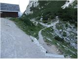 2
2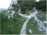 3
3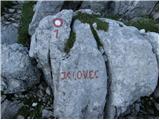 4
4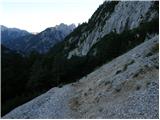 5
5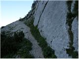 6
6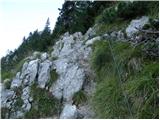 7
7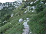 8
8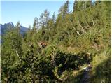 9
9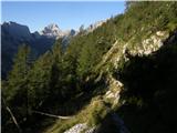 10
10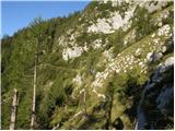 11
11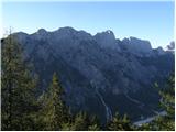 12
12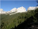 13
13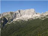 14
14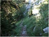 15
15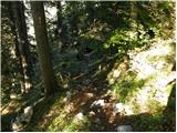 16
16 17
17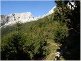 18
18 19
19 20
20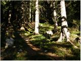 21
21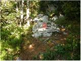 22
22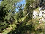 23
23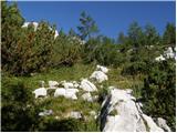 24
24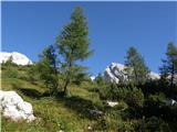 25
25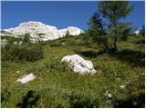 26
26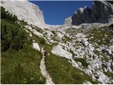 27
27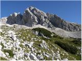 28
28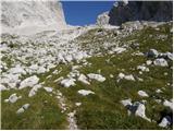 29
29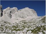 30
30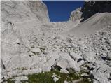 31
31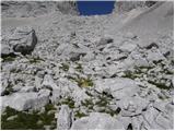 32
32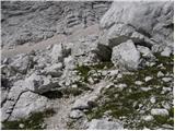 33
33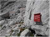 34
34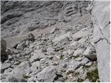 35
35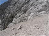 36
36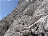 37
37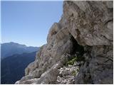 38
38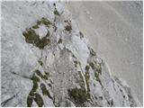 39
39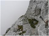 40
40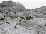 41
41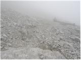 42
42 43
43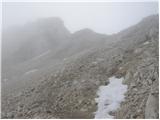 44
44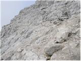 45
45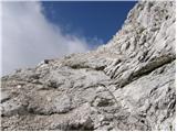 46
46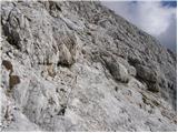 47
47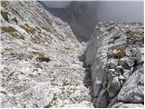 48
48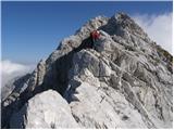 49
49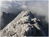 50
50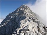 51
51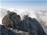 52
52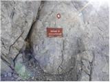 53
53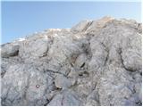 54
54 55
55
Discussion about the trip Vršič - Jalovec (via Jalovška škrbina)
Show older messages
|
| ROBERT18. 08. 2006 |
The path to the crystal mountain is phenomenal! There are people who comment that the path was demanding. I don't understand such people!! Jalovec was no harder than Šmarna gora. To anyone who thinks otherwise, I don't recommend a trip to the high mountains!! In short, Jalovec fulfilled my expectations!!
|
|
|
|
| Gost20. 08. 2006 |
Either you weren't on Jalovec or not on Šmarna gora!
|
|
|
|
| ROBERT22. 08. 2006 |
Dear "guest" I have to admit I've been on both, unlike you who apparently haven't been to Jalovec... or didn't take this path like I did!
|
|
|
|
| Gost24. 08. 2006 |
Better stick to Šmarna gora, because people with statements like yours (comparing the difficulty of the Jalovec path and ŠG???) don't belong neither in the high mountains nor on this forum. And one more thing. I've probably been to Jalovec more times than you've seen it.
|
|
|
|
| Gost24. 08. 2006 |
Robert, it would really be better if you shut up, you seem like a random guest who doesn't know what difficulty is, because of people like you there are always more rescue interventions. Stick to the lowlands, it will be much better for you and others!!!
|
|
|
|
| Ivo24. 08. 2006 |
I completely agree with the last opinion!
|
|
|
|
| ROBERT24. 08. 2006 |
Dear guests, Ivo and quasi-mountaineers let me tell you that I don't bother with opinions of walkers like you at all!! For me the most important thing is that I was on Jalovec in a relatively short time and that I can compare its difficulty with Šmarna gora and I can prove to anyone who doesn't believe it with a race from Vršič to the top of the crystal mountain. I can't help it, I'm just a RACER!!!!!
|
|
|
|
| Gost25. 08. 2006 |
Keep your imbecilic statements to yourself and don't pollute the forum.
|
|
|
|
| Gost25. 08. 2006 |
Dear ROBERT you probably confused the tavern with this forum. Yes, when you sober up you'll return among ... Use the forum for its proper purpose! Brag in the tavern!!!
|
|
|
|
| Gost4. 09. 2006 |
JOŽE dear ROBERT please don't mislead people. If you had at least a bit of mountaineering spirit, you would respect the mountains in a different way. I doubt you've even been to Š.G.
|
|
|
|
| Gost4. 09. 2006 |
All of you who race so easily and quickly through our hills, before going take a mountaineering guide in hand (T. Mihelič) who very honestly and realistically described the approaches to the mountains and inquire a bit about what types fall from walls. And I agree with all those that such discussions lead nowhere. Someone will really think that hills are just simple. Tavern debates belong in the tavern, let the forum of this website remain what it was intended for at the beginning. Good luck!
|
|
|
|
| solja4. 09. 2006 |
I agree! Mountains must be respected!!! And various Roberts have no place neither in the mountains nor on this forum. Let him sit in taverns and boast to his beer buddies. I would call to ignore Robert (if the editor of this site can't stop him in his ramblings) and not react anymore to his "masterpieces". And a nice mountaineering greeting
|
|
|
|
| Gost4. 09. 2006 |
Thanks Robert, for the only smart thing you've done: YOU'VE LEFT THE FORUM
|
|
|
|
| Gost29. 10. 2006 |
I've also been to the summit of this demanding and beautiful mountain 5 times already, but there's no easy approach from any side, so this Robert is talking nonsense. Good thing I didn't see the forum before when he wrote that rubbish (comparing it to ŠG).......
|
|
|
|
| Adson1. 11. 2006 |
The path from Vršič via Jalovška škrbina is demanding. It mainly requires fitness and some climbing skills. The approach to the wall is long and tiring, as it constantly goes down and up. The wall is poorly protected, mainly with pegs, wire ropes only as a sample (self-belaying not possible). After overcoming the wall, scree awaits us and below the summit some more climbing, but not as demanding anymore. I recommend descent to Zavetišče pod Špičkom.
.......................................
I suggest deleting Robert's posts, as they are pure disinformation.
|
|
|
|
| celica19. 03. 2007 |
Hi
True it's been a while since I was at the top, but I think you're exaggerating a bit. Climbing skills are really not needed to conquer the summit. In the week I was on Jalovec there were quite a few dead, but we know the cause of the slips, which doesn't mean everything is so terrible on a normal ascent. Curiosity and carelessness is most often the ascent problem. If I joke a bit, the difference between Šmarna gora and jalovec is quite a few schnapps. For me it's the most beautiful mountain in the world, also because it doesn't allow schnapps.
|
|
|
|
| Gost19. 03. 2007 |
Whoever at the word JALOVEC only thinks of Šmarna gora has certainly not been to Jalovec yet. I hope they won't either, because they don't have the right attitude and respect towards mountains. And thus no real pleasure and satisfaction either.
|
|
|
|
| michael6615. 06. 2007 |
From the description of both routes to Jalovec from Vršič, I assume that the route via Jalovška škrbina is more suitable for ascent, via Špice for descent. Am I wrong?
|
|
|
|
| Gost15. 06. 2007 |
I also think it's appropriate to go in that direction.
|
|
|
|
| Gost23. 07. 2007 |
on Saturday 21.7.2007 we led the KRKA mountaineering group to Jalovec.
it was really nice but hot.
but I don't understand robert who compares such a peak king of our mountains to Šmarna gora.
jalovec is worthy of respect and triglav is a small cough compared to it
the path is exposed- from the summit and worthy of all respect
whoever gets up there is really a good mountaineer
but anyone can go to šmarna gora
best regards and respect
|
|
|
|
| Gost8. 08. 2007 |
However, the path to Šmarna gora from Vikrči also seemed quite exposed to me (of course a very short climbing section 10 min - among 50 secured paths marked as difficult - not for the vertiginous, while Jalovec from the south is marked as moderately demanding) and well secured. Otherwise, Jalovec is not comparable to Šmarna gora, because the climbing part to it is 2 hours long and somewhat less protected than we are used to elsewhere in Slovenian mountains.
|
|
|
|
| Gost17. 08. 2007 |
And what have you told the hikers who want serious information?
|
|
|
|
| Gost17. 08. 2007 |
I was up there on Wednesday and can say that Jalovec is really the king, worthy of respect.
|
|
|
|
| Gost19. 08. 2007 |
Bullshitters..... Adson, sorry. You're the only one who wrote something sensible. Others first to the mountain, then beer, one, two, three, and discuss and pontificate at the bar. Since that's not enough for you, you also have to bullshit on the forum. 
|
|
|
|
| jalovec20. 08. 2007 |
I have been to Jalovec 223 times in all seasons and all kinds of conditions. It always seemed worthy of respect to me. But for me it is the most beautiful mountain in the world. In my more than forty years of active mountaineering, I have climbed quite a few peaks around the world and have always happily returned to it. A few days ago I climbed it again and met a man equipped as if he came from Mars. He was descending on all fours down the back side and later I checked the summit logbook to see who it was. And lo and behold, that very guy is pontificating in the evening on one of the forums this and that about Jalovec. I think that nowadays most real braggarts boast on Monday morning where they were over the weekend and what they did.
|
|
|
|
| Gost22. 08. 2007 |
What is "equipped like from Mars" for you? 
|
|
|
|
| Gost22. 08. 2007 |
Jalovec, if you have so much experience, why didn't you teach the Mars expedition brains something about mountains, how to descend properly instead of laughing at him and showing off up here, that something is written on the forum if you are not convinced about it? In alpine school they taught me to help people in mountains also with advice.
|
|
|
|
| Gost24. 08. 2007 |
You all have "already" been to Jalovec, but I would like to climb it for the first time. Please advise on the safest ascent to it.
P.S: I would "scold" you a bit! Can one consider oneself a good mountaineer who criticizes Robert even after a year or the one who laughs at the one sliding down on his butt without advising or helping him (still better on the "backside" than on the head). I think every mountain-whether a small cough or the king among peaks-must be respected, take from it and enjoy what it offers, otherwise it throws you out.
|
|
|
|
| Gost25. 08. 2007 |
Yeah, who wouldn't criticize Robert? Be realistic, if you have some experience, judge his "exploits" yourself and scold him a bit. In general, you really shouldn't mess with nature because it "throws you out" too readily.
|
|
|
|
| Gost26. 08. 2007 |
Lady (or miss), I think it's better if you don't write anything more. Because on this forum it holds: If you don't howl with the wolves then ....
|
|
|
|
| Gost26. 08. 2007 |
Jalovec, isn't it the same if you boast here on the forum (223x?) or in the bar over a beer ?
|
|
|
|
| Gost28. 08. 2007 |
 you are all such aces that I doubt your mortality you are all such aces that I doubt your mortality
|
|
|
|
| Gost29. 08. 2007 |
I suggest you go with Robert together to the mountains, and we will read your fairy tales with bated breath. Then someone will add a comment, if allowed of course. Or will you forbid it? What arrogance, we wouldn't expect such from a real female mountaineer. Best regards. Mrs. Olga
|
|
|
|
| Gost29. 08. 2007 |
Oh you Olgica, what are you advising me! You forget that Robert is a racer, I hike in the mountains in first gear (if you know what that means). No need to resuscitate you due to shortness of breath while reading our fairy tales.
I see it's really best (...if you don't howl with wolves...), to shut your trap and withdraw from the scene!!
To you friend, thanks for the link, have a nice day and good luck. Pity there aren't more like you on this web.
|
|
|
|
| Gost29. 08. 2007 |
Silly squabblers, with all due respect, JALOVEC is a top-notch guy!
|
|
|
|
| Gost30. 08. 2007 |
One smarter than the other....
|
|
|
|
| Gost30. 08. 2007 |
Good thing there aren't many like you, with such culture, vocabulary,... First clean in front of your own doorstep. Then go chop wood pal. Advice for you is really wasted, because fewer such people in the mountains like you. Especially on Jalovec, it's too beautiful for you to pollute it with your presence. As the guest before me said, Jalovec is a top guy.
|
|
|
|
| Gost30. 08. 2007 |
The lady really has more experience with ugly insults than in the hills, let alone mountains. Chasing someone from the forum (her way) off the scene. Why? And she herself doesn't know what she wants. Ridoti! What does that mean? Only "mountaineers" from her scene know that. I've been to Jalovec many times and will go again. Unfortunately I meet more and more like her. Greetings to all true-hearted mountaineers.
|
|
|
|
| Gost5. 09. 2007 |
Can someone describe a comparison between the ascent to Škrlatica and Jalovec? Nice greetings!
|
|
|
|
| Gost10. 09. 2007 |
Both summits are demanding, large elevation gain, on the summit pyramid you have on Škrlatica also a secured climbing path. For both summits helmet and for Škrlatica a via ferrata set warmly recommended.
LP
|
|
|
|
| Gost10. 09. 2007 |
If Jalovec were a real tough guy he wouldn't insult people and would rather give advice like REAL mountaineers do. If Jalovec were a real tough guy he wouldn't hide behind Gost. If Jalovec were a real tough guy he wouldn't write to himself....lol
|
|
|
|
| Gost10. 09. 2007 |
Thank you very much for the reply. I was on Škrlatica last September. The ascent was tiring, but it remained in my very good memory. Since I'm also planning the ascent to Jalovec, I was a bit scared because of various comments. Based on your reply, I think I'll manage it.
Best regards!
Marija
|
|
|
|
| jamesjoyce12. 09. 2007 |
Hey, I went to Škrlatica about a week ago, and this Sunday to Jalovec. Although the ascent is quite influenced by subjective factors (mood, relaxation, excitement), for me Jalovec was harder, more dangerous, took an hour longer despite similar elevation difference. But the landscape is even more beautiful to me, so the path is super. I went up via Kotovo sedlo and climbing through the walls was not easy at all for me. It's less (read rarely) secured than many other mountains and you have to make quite an effort to go safely through. Now there are already snow patches in the upper part, so you need to be properly shod and careful.
|
|
|
|
| Gost29. 09. 2007 |
Robert, 6 hours to Jalovec? You're really a racer, me like a snail. With a colleague we got up in well under 4 hours, and we didn't go that fast, no mistake, from Vršič. And don't spout nonsense that Jalovec is the same as ŠG. Obviously you're not right in the head.
|
|
|
|
| Gost8. 10. 2007 |
Well, yes, it's true that I've been to Jalovec only about 6-7 times. The first time I climbed it by going from Mojstrovka over Travnik as far as possible, then on this old path that runs parallel to the traverse to Mize and then towards the notch. The day was nice, I was young and cocky. At the beginning of the secured section over the Škrbina it said that the path is very, very demanding and that the inexperienced and those who can't handle heights should rather avoid it. I climbed it easily and upon reaching the summit declared, piece of cake. Only the view into Ozebnik was a bit scary. The second time I went the same path as described in this post, it was after rain and in fog. My opinion on the ease of this path (over Škrbina) changed considerably. It was slippery and much more demanding than the first time.
So, the same path can be rated very differently. Nevertheless, it is very sensible to follow the instructions from relevant guidebooks, like Mihelič's.
Best regards.
|
|
|
|
| Gost2. 11. 2007 |
You need to climb Jalovec on November 1st, light a candle, and what more can I tell you wise guys on this forum ???
|
|
|
|
| Gost25. 12. 2007 |
What's with you people, are you organizing a world championship in fast hiking on Jalovec?
|
|
|
|
| Gost25. 12. 2007 |
Come on Thursday with me, I'd like to see you!
|
|
|
|
| Gost1. 01. 2008 |
I ascended Jalovec for New Year's Eve. Conditions excellent, occasionally small icy patches. At the summit complete calm and unique views. I couldn't wish for a better New Year's gift and felt some inner satisfaction. Where are the pessimists and advisors?
|
|
|
|
| Gost11. 01. 2008 |
all congratulations Guest. This year I'm heading to Jalovec. The wish is possible also because that was my maiden name. Nice, isn't it?
|
|
|
|
| Gost11. 01. 2008 |
The surname is already nice and if I judge by the surname then your husband was very lucky to catch her.
Jalovec is a mighty mountain so prepare well for the ascent.
|
|
|
|
| gad6. 04. 2008 |
It was interesting to read your argumentative discussion about Jalovec and our beautiful peaks on this site, you know what, all of you who wrote this have no idea about Slovenian peaks, no point in arguing, better enjoy nature and conquer many more peaks, best regards from the snake
|
|
|
|
| andrej7677. 04. 2008 |
I really don't know what you're basing that on? Jalovec is definitely a demanding hike from any direction and whoever gets up there and back down in one piece must feel like a king at least that day.
|
|
|
|
| jaz15. 10. 2008 |
Climbed to the summit today. There is still quite a bit of snow in certain places, but it was south-facing. Weather phenomenal. I think it was just the right day, because I've never seen so many larches and beeches in such wonderful colors. Chamois are enjoying the silence of the mountain world and on the summit choughs kept me company, what more could I want. Tomorrow it will already be a completely different day. LP!
|
|
|
|
| bfine44425. 07. 2009 |
Hello! Simple question. Is Jalovec really the king of our mountains and in that regard the most difficult mountain to reach for hikers? Please reply as soon as possible because I have friends who, in my opinion, don't take it seriously and plan to climb it in the near future.
|
|
|
|
| Klin25. 07. 2009 |
Jalovec is not the most difficult mountain to reach, but it is among the most difficult in our mountains and requires good physical and mental fitness.
|
|
|
|
| bfine44425. 07. 2009 |
Is it comparable to Mojstrovka and Triglav?
|
|
|
|
| JusAvgustin26. 07. 2009 |
Hello, I'm heading to Jalovec next week and I'm wondering if it's really the most difficult Slovenian mountain. How is the trail, the condition of the climbing section, any information is welcome. Nice hiking greetings.
|
|
|
|
| 5Xum29. 07. 2009 |
I can't say it's the hardest, but I just returned from the Goličica wall...
My first advice would be to be careful even before entering the wall, because the markers are a bit outdated and one can easily miss them, but there are also neatly built stone pyramids to help, which somewhat replace the markers.
The wall itself I wouldn't say is sparsely protected, but the fixed protections are mostly pitons and not so many cables (wire ropes). The wall is dizzying, the ascent is almost straight up, but in the hardest part without loose stones and completely dry.
The mountain certainly isn't the hardest, since the ascent past the shelter below Špička is easier than Triglav, but it's strenuous.
|
|
|
|
| JusAvgustin31. 07. 2009 |
thanks a lot for the tips, I was up there yesterday. Now I know why it deserves the title of the most beautiful in Slovenia. The path is quite strenuous but doable. When I reached the wall I encountered the problem of faded markings, in some places slightly worn pegs and ropes, but it went without issues. I went from Tamar over Kotovo sedlo to the top. I recommend to everyone who hasn't been yet, the mountain is worth all the efforts. thanks a lot for the reply 5Xum.
|
|
|
|
| MONTI18. 08. 2009 |
I plan to go to Jalovec this weekend. I'm interested in the conditions if I go from Tamar and turn left into Jal. škrbina. They say there might be snow problems there (return via Kotovo sedlo). I've already been to Škrlatica, Triglav and all higher two-thousanders here, so I'm quite experienced mountaineer (wire ropes and pitons of all kinds don't bother me), but not a free climber. If anyone has another - moderately difficult variant for Jalovec, I'd appreciate advice.
Thanks in advance.
|
|
|
|
| jersy18. 08. 2009 |
From Tamar via Jalovška škrbina you need at least an ice axe, crampons are also recommended. The wall of Goličica is dry, also no problems via Kotovo sedlo. Best regards
|
|
|
|
| tanja7919. 08. 2009 |
Tomorrow we are heading to Jalovec. I'm interested if the road from Planica to Tamar is really closed to cars? How can one get from Planica to Tamar as quickly as possible in that case? Thanks and best regards, Tanja
|
|
|
|
| franc7019. 08. 2009 |
The road from Planica to Tamar is officially closed to visitors (except landowners and keepers...), the barrier has been removed since last year. Last Saturday there were quite a few cars at the parking lot before Tamar...
|
|
|
|
| kanjavec25. 03. 2010 |
-šodrovec-
25/03/2010
robert!
you wrote correctly that ŠG = floppy ass or screamer and not racer.
have a nice day!
|
|
|
|
| EUGEN26. 03. 2010 |
Why so much impatience towards those who think differently?????????
|
|
|
|
| šodrovec26. 03. 2010 |
Off the main topic, I'm speaking up (only) in defense of my good name (well, forum nickname "šodrovec"). 
I don't know if perhaps kanjavec thought that the nickname šodrovec would display on the left instead of kanjavec and thus wanted to hide his impatient response to a several years (!) old polemic behind my nickname or something else? Simply, I don't understand! Maybe kanjavec explains to us!?
In short, to conclude, I am not and do not intend to participate in polemics about Jalovec and (not)difficult paths to it.
|
|
|
|
| kkXhc20. 08. 2010 |
Given that my name is Jalovec, I'm going to Jalovec tomorrow! I'm interested which path is more difficult, from Tamar over Kotlovo sedlo or over Jalovško škrbino and if it's harder compared to over Prag to Triglav?
|
|
|
|
| viharnik20. 08. 2010 |
Already the approach from the entrance of Jalovec couloir around 2000m, the climbing section of the Jalovška škrbina wall is more demanding. Over Goličica and further to the summit again requires caution and secure climbing. Still, the easier approach is from Kotovo sedlo via the NW ledge, where we watch the scree underfoot, nothing else difficult there. Both paths to Jalovec are in my opinion more difficult than Prag, but don't cause problems to experienced ones. Nice ascent, Jalovec!.
|
|
|
|
| drago128. 08. 2010 |
Nice greetings to all admirers of this mighty mountain!
My experiences go back about 30 years (!!!), when in the family circle we "collected" stamps of the traverse under father's conducting baton.
I conquered Jalovec with the legendary Franclna entry at Špička. Part of the path was quite airy, I also remember numerous memorial plaques of visitors who tragically ended their ascent of the mountain. I don't remember anything else.
But since some are for these tricks and some are not (and I am among the latter), after returning to Vršič I also concluded my paths in the high mountains.
So I would suggest that various racers and underestimators of Jalovec think about what they publicly announce! People read this and then we can have trouble and some new plaque in memory!
|
|
|
|
| vik19. 07. 2011 |
Almost a year without any record of this beautiful path to the mighty mountain. The path is truly wonderful, the flora along it unique. Views on Sunday were a bit less, opened up here and there a little, but the summit not at all. Towards the summit and along the ridge a strong cold wind, in shelter OK. Protections sufficient, but need to be careful. Quite a few people and some stones whistling close to the head/helmet. Back towards Zavetišču pod Špičkom real rock garden for alpine botanists. Back from the hut quickly, some raindrops fell and at the end the climbs towards Vršiču where you descend to Trenta in the morning. Jota well deserved. Nice, but need to repeat from Tamar sometime in better visibility weather. The Italian hikers who got lost from the Tamar direction and were only today rescued by mountain rescuers are already home.
|
|
|
|
| slavi090219. 07. 2011 |
regarding the Italian hikers whom they rescued for two days.... such things annoy and sadden me.... why the hell did they have to go into the wall when they were advised against it at Tamar, they endangered their own lives and the lives of our rescuers
|
|
|
|
| jani110716. 08. 2011 |
hi, I have one question:
I haven't been to Jalovec yet, so I'm interested which route is the most suitable for ascent and how much time you need for descent to get to Zavetišče pod Špičkom.
thanks lp
|
|
|
|
| otiv16. 08. 2011 |
jani1107 Everything depends on experience and fitness, all routes are demanding. Somehow the most visited is from Zavetišče pod Špičkom.
|
|
|
|
| mdj1. 09. 2011 |
well let me say, I've long wanted to conquer this mountain, so I'd ask if the path is more demanding than the path to Triglav itself, because I hear from some that it's very demanding and that's why I greatly admire Jalovec, and of course respect it
|
|
|
|
| ljubitelj gora1. 09. 2011 |
I recommend the easier path from the shelter below Špičko.
To Triglav there are several paths of different difficulty, the easiest to Triglav is from Krma and the hardest via Luknja, through Plemenice.
You can also go from Planica, take a via ferrata set with you and go through Škrbina, back to Kotovo sedlo. Be careful for sure.
|
|
|
|
| mdj1. 09. 2011 |
yes of course, caution comes first, thanks a lot,...I conquered Triglav via path over Prag, then back over Tominškovo so I'm familiar with difficulty of such paths,...anyway hope I manage to conquer this magnificent mountain JALOVEC
|
|
|
|
| main4. 10. 2011 |
At Vršič, the sign says Jalovec 5h, in this direction.
|
|
|
|
| 1markost11. 08. 2012 |
Today I descended via Jalovška škrbina. The path is nice, scenic but in my opinion too poorly marked for descent. I believe many do not descend here (today the only one) but nevertheless the path should be better marked downwards. First I missed it right at the start of the wall under the scree below the glacier. Secondly, when I descended from the wall to the scree below the notch and went straight down because it seemed most trodden there. The path actually goes a bit to the left, which I only realized below among the boulders. Well, I found the path and safely returned to Vršič. The next descent from Jalovec will definitely not be on this path. I would praise the friendly caretaker of Zavetišče pod Špikom.
|
|
|
|
| honda60016. 08. 2012 |
The path is too poorly marked also for the ascent. I can't imagine being caught by fog on the part when you go above the tree line. In my opinion, it hasn't been renewed (marked) for at least 30 years.
My wife and I were on Jalovec 14 days ago on this path. In the whole day we met 3 hikers. It was great.
And one more thing. 30 years ago the shelter was really a shelter, now it's a hut. But every hiker must visit this hut, it's legendary to me, with a wonderful view of Triglav and other mountains. To me this Špiček is really the best. Lots of enjoyment.
|
|
|
|
| matdra26. 08. 2012 |
One question: comparison of this path to Jalovec compared to Prisojnik past Ajdova deklica? There are many comments about the horror of the ridge and the exposure of the wall. Thanks in advance
|
|
|
|
| NEIC00826. 08. 2012 |
The trail to Jalovec is easier..
|
|
|
|
| 1markost6. 09. 2012 |
Matter of personal judgment. I'd say that to Jalovec it's a bit easier but it's also less secured so requires more caution (via Jalovška škrbina). As said, but above all poorly marked.
|
|
|
|
| fpetel118. 08. 2013 |
This year I'm a bit weaker in fitness. Which path do you recommend? From Vršič or from Trenta? Probably Vršič? Which path is more scenic? I've already been from Tamar over Škrbina and Goličica up and over Kotovo sedlo down.
thanks for the answer
and best regards Franc
|
|
|
|
| malimiha31. 08. 2015 |
Hello,
I'm interested in the difficulty of the path and which climbing path here can it be compared to.
I have already gone from Tamar through Kotovo Sedlo to the top. Is this one much more demanding? Thanks and best regards, Miha
|
|
|
|
| ločanka31. 08. 2015 |
A lot of caution and concentration is needed on this path, especially on the section through Goličica. You have to look around a bit for the marks, some are also very old. I think it is more demanding than the one through Kotovo Sedlo.
|
|
|
|
| Marta Samotorčan31. 08. 2015 |
Well, I managed it. Jalovec, of course. I tackled it with great awe. For me, it was one of the most demanding hikes. (Past Zavetišče pod Špičkom)But now I tell myself: "If I managed Jalovec, there's nothing in the valley I couldn't handle. I'm really proud of myself and this ascent gave me new energy.
|
|
|
|
| Nina Špik9. 11. 2015 |
hi! Has anyone hiked this trail in the last week? What are the conditions? Any snow?
|
|
|
To post a comment you must log in:
If you do not yet have a username, you must first
register.