Vršič - Jalovec (via Zavetišče pod Špičkom)
Starting point: Vršič (1611 m)
| Latitude/Longitude: | 46,43360°N 13,74350°E |
| |
Route name: via Zavetišče pod Špičkom
Walking time: 6 h
Difficulty: very difficult marked way
Elevation gain: 1034 m
Elevation difference along the route: 1450 m
Map: TNP 1:50.000
Recommended equipment (summer): helmet, self belay set
Recommended equipment (winter): helmet, self belay set, ice axe, crampons
Views: 137.777
 | 5 people like this post |
Access to starting point:
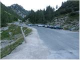
From Kranjska Gora we drive towards Bovec or vice versa, but only to the Vršič pass, where we park.
Route description:
From the parking lot at the Vršič pass we head in the direction of Trenta, where we quickly arrive at a small intersection, where to the left a road closed to public traffic branches off towards the nearby Tičarjev dom and which leads further to Poštarski dom, while we go right, where next to the wooden cabin where they sell various souvenirs we notice the start of the marked path leading towards Jalovec and Zavetišče pod Špičkom.
The path already after a few steps brings us to the foot of the scree under Mala Mojstrovka, while we keep slightly to the left direction, where the path through a belt of dwarf pines takes us to the foot of the cliffs, along which we descend a little. In continuation the path is initially still quite scenic and takes us in a few shorter ascents and descents to a shorter steeper section, where at two more difficult places we are helped by safety features, which come in handy when the path is wet or slippery. After the mentioned section the path gradually begins to descend transversely, and we descend for quite some time, so we get the feeling that the path will take us into the valley and not into the world around Jalovec. During the crossing we occasionally get a nice view of the mountains above the Trenta valley, when the path returns to the forest we arrive at a marked junction near the hunting lodge in Rutarska Trenta, which is set a bit off the marked path.
We continue straight in the direction of Zavetišče pod Špičkom (left Zadnja Trenta, right Jalovec) where a few more successive junctions follow, we follow the marked path in the direction of Zavetišče pod Špičkom. The path ahead begins to climb more seriously for the first time, we climb mainly transversely to the left, where when we leave the forest or it thins out we arrive under the cliffs, where we ascend on a rockier path, along the path the terrain is still quite grassy or overgrown with dwarf pines and bushes. Further on more and more beautiful views open up, our gaze quickly goes to the interesting sharp peak Špiček under which Zavetišče pod Špičkom is located, while looking back we get a view of Prisojnik, which is already quite distant, especially if we consider that we started hiking in its vicinity. Later the path turns slightly to the left or southwest and then joins the path from the starting point in Zadnja Trenta.
We continue straight, or slightly to the right and continue to follow the signs for the shelter, the path gradually transitions into the world of pastures. Higher up from the increasingly scenic path the path towards Jalovec branches off to the right, which bypasses the shelter, while we amidst numerous verses with interesting inscriptions in a few minutes of further walking arrive at Zavetišče pod Špičkom.
From the shelter we return a bit back and then head on the path in the direction of Jalovec, where the path quickly takes us to the climbing part of the trail.
The path ahead ascends along an initially relatively well-secured rocky rib, then steeply climbs the wall of the lesser-known Veliki Ozebnik (2480 m). The steepness then gradually eases and the path turns slightly to the right, where it crosses steep slopes dangerous for slipping under Veliki Ozebnik. The path in this section is less secured and very exposed to falling rocks (helmet is mandatory!). The path ahead crosses yet another short exposed gully and then brings us to the softer world of grass. The path ahead slightly descends and brings us to the high-mountain plateau named Jezerce. A short ascent follows and from the right the path from Jalovška škrbina joins us.
The path then climbs steeply again and with some safety features along a sometimes quite exposed path brings us to the main ridge of Jalovec. Further we ascend along the narrow and occasionally very exposed ridge on the path that higher up brings us to the place where from the left the path from Kotovo sedlo joins us. We continue straight and the scenic ridge path quickly brings us to the summit of Jalovec.
Vršič - Rutarska Trenta 2:15, Rutarska Trenta - razpotje pod Špičkom 0:40, razpotje pod Špičkom - Zavetišče pod Špičkom 0:50, Zavetišče pod Špičkom - Jezerca 1:25, Jezerca - Razpotje na grebenu Jalovca 0:45, razpotje na grebenu Jalovca - Jalovca 0:05.

Along the route: Rutarska Trenta (1546m), Razpotje pod Špičkom (1769m),
Zavetišče pod Špičkom (2064m), Jezerca (2390m), Razpotje na grebenu Jalovca (2613m)
Photos:
 1
1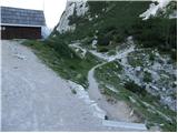 2
2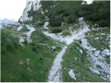 3
3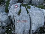 4
4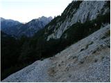 5
5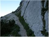 6
6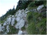 7
7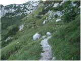 8
8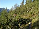 9
9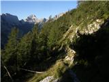 10
10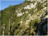 11
11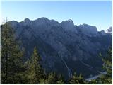 12
12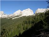 13
13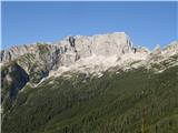 14
14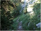 15
15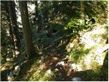 16
16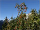 17
17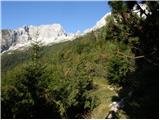 18
18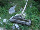 19
19 20
20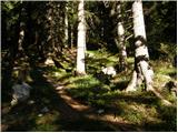 21
21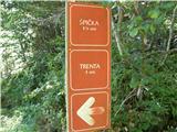 22
22 23
23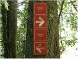 24
24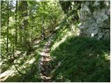 25
25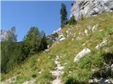 26
26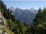 27
27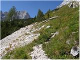 28
28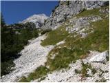 29
29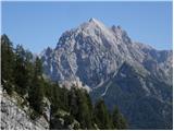 30
30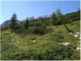 31
31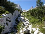 32
32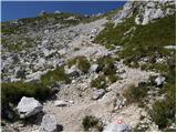 33
33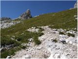 34
34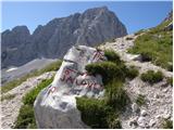 35
35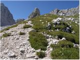 36
36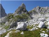 37
37 38
38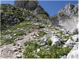 39
39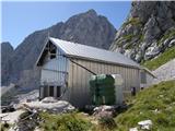 40
40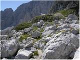 41
41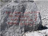 42
42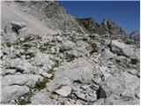 43
43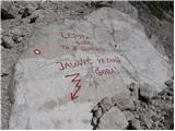 44
44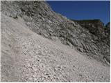 45
45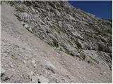 46
46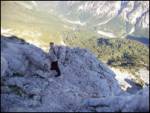 47
47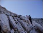 48
48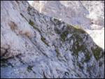 49
49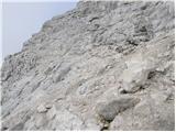 50
50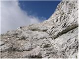 51
51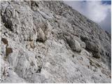 52
52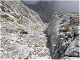 53
53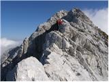 54
54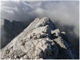 55
55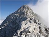 56
56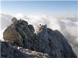 57
57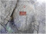 58
58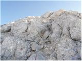 59
59 60
60
Discussion about the trip Vršič - Jalovec (via Zavetišče pod Špičkom)
Show older messages
|
| Gost15. 09. 2006 |
The path from Vršič to the shelter below Špička drags on, but from there to the top it is very interesting and varied. Best, Rok
|
|
|
|
| Gost30. 10. 2006 |
I hope there is peace in the high mountains and they are not rattling with chainsaws on Sunday. I experienced this horror on Lipanci. Next to the hut there is another one and they were hammering as if it were a workday. Can this be prevented? We go to the mountains for peace. Thanks to everyone who will do something to ensure silence and peace on Sundays in the mountains.
|
|
|
|
| Gost31. 10. 2006 |
I assume that maintenance work on alpine huts and pastures is mostly done with volunteer labor, i.e. after regular work - so let's be patient a bit, as mountain facilities also need to be built and maintained. But it's very comfortable after a strenuous tour to arrive under a friendly and tidy roof.
|
|
|
|
| Gost31. 10. 2006 |
Almost everything in the mountains (from huts to trails) is on a voluntary basis.
That's why we should be grateful to these people, not criticize them for doing what doesn't suit us.
Some also have to make a living from/in the high mountains.
|
|
|
|
| Gost31. 10. 2006 |
Hey, I'm not talking about mountain huts. Read it again. I didn't write a single word about mountain trails either. Thanks anyway. I know it was well-intentioned.
|
|
|
|
| Gost6. 12. 2006 |
Jalovec tempts me. Where is the easiest path to it?
|
|
|
|
| Gost6. 12. 2006 |
The easiest or least difficult access to the summit is from the shelter under Špičkom. To the shelter, you can go from Vršič or Trenta.
|
|
|
|
| Gost6. 12. 2006 |
thanks, I'm already looking forward to August 2007, when I hope to complete SPP. Best, Leja
|
|
|
|
| Gost21. 12. 2006 |
Jalovec is still the king of our mountains. This year's beautiful season allowed me to conquer it for the sixth time in fifty years.
|
|
|
|
| Gost16. 04. 2007 |
oh! i'm interested in the descent from jalovec. is this in the direction of špička??
thanks and lp
|
|
|
|
| Gost16. 04. 2007 |
There is no descent from Jalovec, but from Jalovec towards the shelter under Špičkom.
|
|
|
|
| LISO15. 07. 2008 |
Nice excursion. Towards the summit lots of fallen stones. Helmet is mandatory.
|
|
|
|
| Mirko0128. 08. 2009 |
I plan to sleep in Zavetišče pod Špičkom (one-day tour is too strenuous for me). Since I've never been to the shelter, I'm curious about the conditions. On the PD Jesenice website I read it has 30 beds. Is it crowded during the week? Is reservation necessary? Thanks for help!
|
|
|
|
| v.blazins28. 08. 2009 |
those are the real and very nice photos Matjaž, 10/10 with great weather
|
|
|
|
| NEIC00828. 08. 2010 |
27.8.2010 set off for Jalovec. Weather cloudy, windy, in short I saw nothing but the path, let alone any views. Will have to repeat the exercise. To the top 5 hours and then quickly back. Still the last 1.5 hours in heavy rain back to Vršič.  The path from Vršič seems more suitable to me than the one from Trenta although it is longer (time-wise not), because the elevation gain is smaller. The path from Vršič seems more suitable to me than the one from Trenta although it is longer (time-wise not), because the elevation gain is smaller.
|
|
|
|
| mrobert20023. 09. 2010 |
I'm new to this forum. I have a question. The path is marked as a very difficult marked path. How to distinguish e.g. Prisojnik via the last window (http://www.hribi.net/izlet/vrsic_prisank___prisojnik_jubilejna_pot/1/18/1838 ) from this one e.g. to Jalovec. Meaning, the difficulty is the same. Hm. Is that possible?
|
|
|
|
| Tadej23. 09. 2010 |
Hello mrobert200
On the Hribi.net portal there are several difficulty levels, divided from easy to extremely demanding.
The "very demanding" label means that there is one or more very demanding spots on the path.
Of course, within the same group there are paths that differ in difficulty from each other (some easier, others harder). It depends a lot on each individual. For one, the Jubilee Path is easier, for another the path to Jalovec, but both are very demanding.
|
|
|
|
| ljubitelj gora23. 09. 2010 |
I have studied this myself, it would be fine if we added difficulty levels for demanding marked paths (1st degree, 2nd degree), very demanding, extremely demanding.
For example, Kepa from Dovje and Belca is a demanding path, but from Dovje it is a harder path than from Belca, the difference is like day and night.
|
|
|
|
| merkur24. 09. 2010 |
Two questions. Thanks in advance for answers!
Approximately how many minutes (by feel) of normal walking is needed to go from the water trough (19th picture) to the junction (20th picture) or to the hunting hut, if we turn left at the junction towards it?
Does anyone know the current condition of the bivouac in Zavetišče?
|
|
|
|
| petruša24. 09. 2010 |
Hello merkur.
We did this path in August with children. We were also at the hunting hut because we had a snack there. From that picture which is the trough (picture 19) to the hunting hut it's less than half an hour walk. lp.
|
|
|
|
| snežinka1. 10. 2010 |
From the top of Jalovec, a magnificent view.
|
|
|
|
| snežinka1. 10. 2010 |
I tried to add some pictures, but it didn't work
|
|
|
|
| merkur2. 10. 2010 |
Thanks, petruša. Thanks, matta. If it's documented, then it holds! Of course, human memory quickly distorts things.
In the meantime, I got info: winter room in Zavetišče as before = rudimentary.
|
|
|
|
| Parkeljc16. 10. 2010 |
Yesterday, my colleague and I caught probably the last nice day. As forecasted, snow will fall in the high mountains, but it might not melt until next year. Perfect for a full-day trip to Jalovec. We counted very few visitors that day. About seven including us.
Somewhere from Mali Kot along the climbing path to the scree I lost my foldable hiking pole "Black Diamond". If anyone found it and took it, please let me know (parkeljc@gmail.com).
|
|
|
|
| irena25. 06. 2011 |
Very nice hike, few visitors today and I think no one from this direction reached the summit - at least the snowfield (about 1 hour before the top) was untouched,.. we watched 2 hikers descend and we turned back under the snowfield. Zavetišče pod Špičkom is closed too... and worst, I didn't find the stamp.
|
|
|
|
| sergejjj11. 09. 2011 |
Irena I too planned with my buddy to conquer the peak on 22.6. and we also turned back at the snowfield plus thick fog was an obstacle too. We too were disappointed because of the stamp but the photo counts as well. Anyway a repeat ascent will be needed anyway to conquer the summit 
|
|
|
|
| metod11. 09. 2011 |
Today it was hot! Especially to the Shelter. Good thing the summit was in fog, it burned a little less. Otherwise nice and interesting. Just some markings have faded a bit so need to pay attention. Again sometime!
|
|
|
|
| malihodec22. 06. 2012 |
Are the conditions suitable for an ascent to Jalovec yet? I would like to start from Vršič in the afternoon, overnight in the bivouac shelter and summit in the morning then down to the valley. Thanks for info
|
|
|
|
| IgorZlodej22. 06. 2012 |
What kind of ascent, suitable of course they are. But do you know if the bivouac is open!?
|
|
|
|
| turbo22. 06. 2012 |
Too bad, because I'm so old  and modestly satisfied with every summit I get to step on Where would I conquer and attack them let alone assault and modestly satisfied with every summit I get to step on Where would I conquer and attack them let alone assault
|
|
|
|
| Scabiosa23. 06. 2012 |
The last three comments really make me laugh! 
|
|
|
|
| jax23. 06. 2012 |
Yeah, true, I saw those comments on the front page yesterday and hurried to check where some mischief was hiding. And I was quite disappointed when I saw it was just about conditions ...
|
|
|
|
| malihodec28. 06. 2012 |
And if, dear hikers, you answered only what the person asks, I would be VERY GRATEFUL to you. Based on your profound comments, however, I must conclude that some care more about belittling and insulting those who use a slightly different language than they are used to.
I hope next time I get help and useful advice from you, not language lessons.
But thanks anyway, especially to Igor!!!???
|
|
|
|
| Parkeljc28. 06. 2012 |
malihodec, Zavetišče pod Špičkom officially opens on 5.7.2012, but the winter room IS OPEN I haven't been up, but learned from a buddy who was up three days ago that the path is dry
Reconcile yourself with the fact that some people nitpick every word you say (if possible) interpreting it a bit differently There is still snow in Jalovška škrbina and Ozebnik !
|
|
|
|
| Parkeljc28. 06. 2012 |
PS:
If some can jog, others run, third fly,..in the mountains, I don't know why you shouldn't be allowed to tackle and attack them, the mountains, so there's no mistake
Just be careful not to injure yourself or someone else !
|
|
|
|
| turbo28. 06. 2012 |
Slowly but surely you get far 
Too fast is too fast 
|
|
|
|
| malihodec30. 06. 2012 |
Parkeljc, thank you very much for the information. And I wish all hikers and mountaineers people like you, who want to help regardless of the words used. As for injuries, I have to knock on wood, I haven't caused any in my hiking in the mountains so far!!!
|
|
|
|
| vikikrema12. 08. 2013 |
Can anyone tell me how much real walking time there is on the above described path to the summit of Jalovec? Nails are gone , but fitness is there , but fitness is there
|
|
|
|
| dolenjka&primorc12. 08. 2013 |
In the opposite direction with a 25-minute stop at the shelter below Špička we needed a good 4 hours ..
|
|
|
|
| kraševec21. 11. 2013 |
End of September conquered Vrh Jalovca, route Vršič-Jalovška škrbina past Veliki ozebnik and to Jalovec summit. With good fitness and little break 4 hours walking. Return past Zavetišče pod Špičkom 3 hours good walking.
|
|
|
|
| JusAvgustin21. 11. 2013 |
this is really up-to-date information
|
|
|
|
| Branee21. 11. 2013 |
just so I can find a prayer rug!
|
|
|
|
| viharnik21. 11. 2013 |
You can get from the top of Jalovec to Vršič via Špička in three hours only with rocket-powered shoes . .
|
|
|
|
| Charly23. 11. 2013 |
viharnik, true, it's not possible to walk the path in three hours, unless you're running yeah...
|
|
|
|
| Becar23. 11. 2013 |
I walked from Jalovec to Tamar in 16 seconds. Now, in the next life, I need 6 hours.
|
|
|
|
| traceour23. 11. 2013 |
And how do you know how others hike in the mountains? I for example have 38min from the lower parking under matizovcam to kofc so what, because I have recreation, some go to enjoy and walk an hour, an hour back.. But hey do I also have rocket shoes? Well, no hard feelings, that's how it is, everyone goes to the mountains for their own reason.. For some it's pleasure to dream on the way and look around every 2m, some go to sport and then enjoy longer at the top..
|
|
|
|
| Busterman24. 11. 2013 |
Oh who cares how much time someone has for a personal record on xyz path. Hiking in the mountains is not done with the reason to arrive somewhere as soon as possible. If you want to tackle mountains really sporty-timewise then start with mountain running, where such measurements are welcome and part of the activity.
Times on hribi.net are given for average hikers and if someone arrives at jalovec in 2.30, that data is useless: it says nothing about whether the path is nice, how much time to calculate when planning a hike, how it is with snowfields etc. Only someone who inquires poorly can be misled by such data and lead to unpleasant situations. So if you already publish some fast times, at least write that it was mountain running/ very fast pace etc.
|
|
|
|
| ljubitelj gora25. 11. 2013 |
The hiking time is what it is, so there is no need to publish it anywhere, but for every 300 meters of elevation gain, count 1 hour of normal walking, that is the standard in all descriptions.
|
|
|
|
| črna murka18. 08. 2014 |
I'm interested, has anyone hiked this trail recently? What are the conditions? Is there any water available along the trail?
|
|
|
|
| matdra18. 08. 2014 |
Conditions are dry, one snowfield that can be bypassed. Water is at the start of the ascent towards Špička. Good luck
|
|
|
|
| malimiha4. 09. 2014 |
I'm curious about the current conditions on this path after the snowfall. Thanks and best regards, MIha
|
|
|
|
| oven1. 07. 2015 |
Hello.
I'm wondering if there's still any snow on this trail?
Best regards
|
|
|
|
| Matej_K.1. 07. 2015 |
Was up there on Sunday. On the saddle between V. Ozebnik and Jalovec you go a couple of steps on snow, but nothing special. Everything else is completely dry.
|
|
|
|
| oven1. 07. 2015 |
Matej thanks for the reply. Then I don't need crampons. Is the shelter under Špičko already open?
lp
|
|
|
|
| ajax1. 07. 2015 |
why wouldn't it be?
|
|
|
|
| Matej_K.2. 07. 2015 |
You don't need crampons on this trail. The shelter under Špička is open. lp
|
|
|
|
| el rocco28. 08. 2015 |
Yesterday my wife and I did this fantastic tour in one day. We started from Vršič at 4:00 am past Špička to Jalovec and back. As average hikers, we took 13 hours total at normal pace (7 up and 6 back). I would advise those planning to go to Jalovec without enough fitness or occasional hikers to rather overnight below Špička and do the tour in two days. Because you need to know that the part from Špička to summit is mostly climbing and more strenuous than the walk from Vršič to Špička. The ascent from Špička itself is not bad, but due to scree you have to watch your steps constantly and caution is indeed in place on Jalovec. Self-belay kit despite a few exposed spots is in my opinion at least in dry not necessary, while helmet is mandatory. Anyway, a great tour behind us, only the path from Vršič to Špička drags on like a chicken's gut
|
|
|
|
| zokica28. 08. 2015 |
Much nicer is the path to Špička if we start the hike at the Koča at the source of Soča. A large part of the path is through the forest on a soft trail.
The path from Vršič really drags on.
For the path from Špička to Jalovec, I still recommend a via ferrata kit, if not for anything else, at least for practice :-)
|
|
|
|
| joža x28. 08. 2015 |
No, I wouldn't agree, to me the path from Vršič was much nicer, but every eye has its own painter
|
|
|
|
| ana28. 08. 2015 |
From Vršič it drags like a chicken's gut. Not to mention the return, you're tired and have to go back up the hill again, even if you have a car at Vršič
|
|
|
|
| lepenatka28. 08. 2015 |
This path isn't to my liking either. One way maybe ok, down to Trenta and bus to Vršič. Timetable until 1.9. is still fine.
True though, I take two days
|
|
|
|
| Nina Špik9. 11. 2015 |
hi! Has anyone hiked this trail in the last week? What are the conditions? Any snow?
|
|
|
|
| Taxi031013. 06. 2016 |
Hello!
Is there still snow on the path to Jalovec from Vršič via the shelter under Špička?
Thanks.
Best regards from Croatia!
|
|
|
|
| Mira.k14. 08. 2016 |
Today on this path, weather was excellent and views fantastic. Only bothered me that markings from the summit back are very poor, and some wire rope from the scree to the summit wouldn't be superfluous.
|
|
|
|
| cormi15. 09. 2016 |
I recommend the starting point in Trenta for men, Vršič for women. Or Trenta for racers, Vršič for those enjoying it
Now seriously. I walked the trail in both directions from Vršič and yesterday also the one to Trenta. The final climb back to Vršič is indeed superfluous, but the trail is varied and offers open views on the Julian Alps all the way. For my taste Vršič absolutely wins and never again to Trenta, where the trail dragged for me - as Ana says for Vršič - like chicken intestines. Which trail is better is of course just a subjective opinion.
|
|
|
|
| lepenatka15. 09. 2016 |
I prefer going to Trenta, the trail from Vršič annoyed me
|
|
|
|
| darinka415. 09. 2016 |
I also from Zapodna. Haven't gone from Vršič yet, because those who came from there said it's long. When descending, the last part of the trail usually drags. Even if it's a one-day tour.
|
|
|
|
| IgorZlodej15. 09. 2016 |
Anyway, the nicest from Zapodna, and you can also make it circular
|
|
|
|
| bo_zl15. 09. 2016 |
On Saturday 3.9. I went from Vršič, then directly past Mali kot to Jalovec. Interesting and exposed climbing on the wall of Goličica. Back to Špička and from there to Trenta. I think this is the most ideal variant. You don't return the same way, the path back to Vršič which really drags on is skipped (experience from 10 years ago), the path from Trenta to Špička is in my opinion strenuous. Descent on it is quite fast and of course much less strenuous. To Vršič then hitchhiking. Slovenes with empty cars don't stop, two Belgians though...
|
|
|
|
| smatjaz13. 10. 2017 |
And does anyone know the conditions from Flori past the shelter under Špička to the summit... is there still any snow and danger?
|
|
|
|
| Batistuta1. 09. 2019 |
I descended from Jalovec along this path. I did the descent to the bivouac the day before, then slept and continued towards Vršič. From the bivouac under Špica I needed 7 hours to Tamar, with a side trip to Slemenova Špica, which offers the most spectacular view of the king of Slovenian mountains - Jalovec.
Descent from the summit to the bivouac is significantly easier than towards Kotovo sedlo (where I ascended) and I recommend it to all those who don't like climbing walls with a lack of pegs and cables.
|
|
|
|
| resar216. 09. 2019 |
On Saturday 14.9.2019 first time on Jalovec.
Ascent from Vršič, over the great scree field. This path is well secured.
Unfortunately I can't say that for Jalovec especially along the ridge, where the path is very exposed.
Descent via Goličica where I missed wire ropes, which are more suitable for descent and ascent than pegs. When I descended from the wall I looked for markers that would lead me over Jalovška škrbina???
Descent over Jalovška škrbina is well secured with wire ropes, the completely bent footrests bothered me a bit.
Then through the scree to the hut in Tamar.
|
|
|
|
| dvojnit4. 08. 2022 15:57:09 |
If you're in good physical condition, don't be intimidated by the estimated timetable. At a good pace and with a few breaks, in dry weather with good visibility, you'll reach the top in 4 hours. Approx. 2:30 to the start of the climbing section, from there to the summit 1:20. For the descent, if you spare your knees a bit, 1:30 to the shelter under Špička and from there to Vršič 2:00.
I had the SVK on me, but didn't feel the need to use it even once. It's good to have it just in case some ailment strikes, etc. Although there are mostly no cables on the path.
Jalovec is a demanding mountain, but I'd say that, based on descriptions of approaches from other directions, this is the easiest (still very demanding!) access.
PS. If you go up and down the same path, I suggest at the junction at Jezerci doing another 200 m towards Jalovška škrbina. There you'll see what I consider one of the most iconic views in our mountains under Goličica through the Jalovec couloir.
|
|
|
|
| Enka12. 09. 2022 17:47:12 |
For my first visit to Jalovec I chose the easiest approach and can only confirm there's no easy path to it. On the slopes of Veliki Ozebnik it's not so crumbly and fixed protections are plenty, at least compared to what's ahead. When the path crosses to Jalovec slope, it becomes more scree-covered, fixed protections few or almost none. Similar on the ridge (2-3 bolts and 2 m cable). For those who - like me - aren't great with exposure, the ridge is really airy and not quite short. Some scree below summit, up top magnificent view and satisfaction it worked. To Špička maximum caution needed even on descent. Time-wise exactly as per timetable.
|
|
|
|
| Tajka6713. 08. 2023 19:39:08 |
Yesterday to the shelter under Špička from Vršič, it drags on and on with no end. Friendly caretakers, everything spick and span. Today at six to Jalovec, weather perfect for photos, on the way back it was already scorching. Just before entering the Jalovec wall, one fixed rope is almost completely torn, only one strand holding it. No crowds, one local from Trenta, fast as lightning, and on the way down 6 hikers. Of course Jalovec is wonderful, but for me the view of the most beautiful sunrise gave it the finishing touch. Back to Vršič though... oh boy
|
|
|
To post a comment you must log in:
If you do not yet have a username, you must first
register.