Vršič - Mala Mojstrovka (Hanzova pot)
Starting point: Vršič (1611 m)
| Latitude/Longitude: | 46,43360°N 13,74350°E |
| |
Route name: Hanzova pot
Walking time: 2 h 15 min
Difficulty: very difficult marked way
Via ferrata: B/C
Elevation gain: 721 m
Elevation difference along the route: 721 m
Map: TNP 1 : 50.000, Kranjska Gora 1:30.000
Recommended equipment (summer): helmet, self belay set
Recommended equipment (winter): helmet, self belay set, ice axe, crampons
Views: 262.517
 | 8 people like this post |
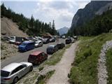
Access to starting point:
From Kranjska Gora we drive towards Bovec or vice versa, but only as far as the Vršič pass, where we park.
Route description:
From the Vršič pass we head onto the path in the direction of Slemenova špica, Hanzova pot to Mala Mojstrovka and the Tamar valley (left - usual route to Mala Mojstrovka) along the path that begins to climb transversely to the right. During the ascent which runs along the slopes of Šitna glava we cross several smaller scree slopes and torrents, after which the path from Erjavčeva koča at Vršič joins us from the right.
Here we continue straight and passing a viewpoint a few meters away, in a few minutes we ascend to the Vratca saddle (1799 m), where the next marked junction is.
We continue left in the direction of Mojstrovka (right unmarked path to Prednje Robičje, straight Slemenova špica) along the path that runs under the walls of Šitna glava. After a few tens of steps further the Hanzova pot to Mala Mojstrovka branches off left upwards (straight Slemenova špica on unmarked path). The path ahead climbs steeply with the help of numerous pitons and higher brings us to the first steel cables, which then become our "constant" companion. The still excellently secured path leads us further over exposed ledges and gullies steeply upwards. The path, which is exposed to falling rocks, gradually flattens and an unmarked path from Šitna glava joins us from the left. After a few more minutes the steepness eases and the path brings us to a more level terrain, which we bypass on the right side. Further the path approaches the ridge, and we see Mangart and Jalovec in front of us. Here the path turns slightly left and brings us to the next steep section, where with the help of a few pitons, mainly without protection, we climb the steep summit slope of Mala Mojstrovka to its panoramic summit.
We can descend via the easier usual route.
Vršič Pass - Vratca 0:35, Vratca - Edge of the north face of Mala Mojstrovka 1:05, Edge of the north face of Mala Mojstrovka - Mala Mojstrovka 0:35.

Along the route: Razpotje pod Vratci (1705m), Vratca (1800m), Severna stena Male Mojstrovke (1865m), Rob severne stene Male Mojstrovke (2116m)
Photos:
 1
1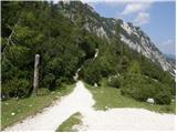 2
2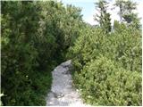 3
3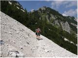 4
4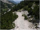 5
5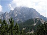 6
6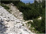 7
7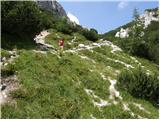 8
8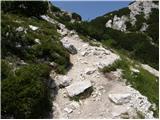 9
9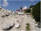 10
10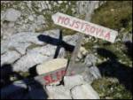 11
11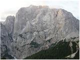 12
12 13
13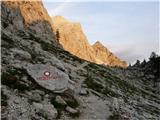 14
14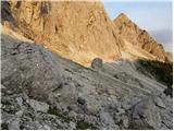 15
15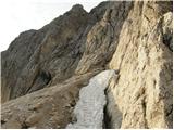 16
16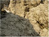 17
17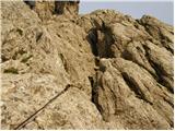 18
18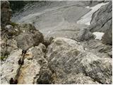 19
19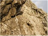 20
20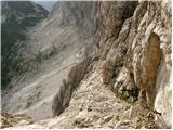 21
21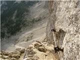 22
22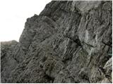 23
23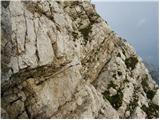 24
24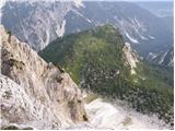 25
25 26
26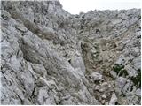 27
27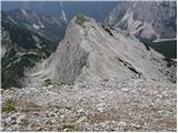 28
28 29
29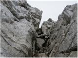 30
30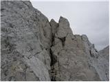 31
31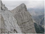 32
32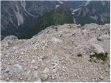 33
33 34
34 35
35
Discussion about the trip Vršič - Mala Mojstrovka (Hanzova pot)
Show older messages
|
| Gost21. 09. 2007 |
very nice and interesting path. In August we climbed it with 11- and 7-year-old children, both enjoyed it. Mom a bit less, due to worries.
Beekeeper
|
|
|
|
| Gost26. 09. 2007 |
You're making mom worry for no reason. Take the kids on age-appropriate tours, there are plenty. Fly up and down yourself and boast about it.
|
|
|
|
| Gost1. 01. 2008 |
I've gone up this path to Mala Mojstrovka several times and it's always a special pleasure. I mainly hike in the mountains in summer, I have no experience with winter ascents, my highest snowy ascent is on Donačka Gora.
|
|
|
|
| saso.alpinist20. 08. 2008 |
This path is really interesting and beautiful, but still dangerous and unsuitable for 7 and 11 year old children, because you always have a 100-meter drop below you. I do not recommend this path to people with vertigo and inexperienced persons.
I am 15 years old but I've been hiking since I was little, so this trip was a real pleasure for me.
|
|
|
|
| grahlck14. 07. 2009 |
I'm wondering if there's any snow on this path?
|
|
|
|
| ana17. 07. 2009 |
Yesterday afternoon we climbed this path, no snow on the path.
|
|
|
|
| domoljub26. 07. 2009 |
The path is fine and well secured. They could perhaps be a bit less stingy with the red and white paint, as the markings have faded in places and are less noticeable. In the second part of the ascent below the summit, they could add a few more pegs. I am somewhat larger and had trouble reaching holds and lifting my legs in places. Otherwise, it's fine. Good luck and much enjoyment to all who tackle it.
|
|
|
|
| andrejjerina6. 08. 2009 |
Well, today my son Jošt and I also set off on the mentioned path to M. Mojstrovka. The path and safety gear are, as previous ones write, in excellent condition. The safety gear is sufficient in my opinion, since sometimes you also need to climb a bit. That's part of high mountains. As for the suitability of the path for children, I look at it very subjectively. If you ensure the safety of yourself and the child (all necessary equipment, rope), and if the child is "experienced" and has no problems with heights and cliffs, I see no reason why they couldn't do such or similar ascents. You just need to bring the child to it in the right way and present it properly. Best regards, Andrej
|
|
|
|
| novinsekp29. 08. 2009 |
Tomorrow I plan to head to Mala Mojstrovka via Hanzova. Given today's bad weather (rain and thunderstorms), I'm wondering if it's worth going tomorrow despite the better forecast. I'm mainly thinking about the slipperiness of rocks etc., due to today's rain? Any experiences? Thanks.
|
|
|
|
| ben29. 08. 2009 |
I think you won't have problems in the rocky section because of that, as the rock dries quickly. You have more trouble in such conditions only on mixed terrain (rock, soil), but there's not much of that there, so go boldly on the path.
Best regards B
|
|
|
|
| mad matheuss29. 08. 2009 |
End of August last year there was a similar weather situation. All Saturday and Saturday night into Sunday it rained heavily. At Vršič it cleared up almost completely at six in the morning.
Then I turned back because of slippery rocks after about 100m of the path (at this crossing: http://www.hribi.net/slika.asp?pot=17654). Continuing would have been suicide. However, I didn't have a self-belay kit with me.
Decide for yourself...
|
|
|
|
| acjom21. 11. 2009 |
does anyone know how much snow there is on the path to Mojstrovka
|
|
|
|
| admpsolar14. 06. 2010 |
In the middle of the week we plan to go to Mala Mojstrovka via Hanzova pot. Maybe someone knows what condition the fixed protections are in and if there's possibly still some snow on the path. Thanks, LP Primož
|
|
|
|
| Griha14. 06. 2010 |
You've probably already seen the photo from 13.6. posted by "bos". So in my opinion it's classic for early summer. There's snow at the start and over the first pegs, higher up it looks ok maybe still some snow just below the summit. http://hribi.net/sliketemp/Slika%200405557445.jpg
I'm also heading out this weekend. Best regards.
|
|
|
|
| jacoby6527. 06. 2010 |
Today my colleague and I headed up Hanzova pot to Mala Mojstrovka. There was a small snow patch at the entrance to the wall before the first pegs, everything else is ok. Happy climbing to everyone heading up!
Good luck
|
|
|
|
| salvinia5. 07. 2010 |
On Saturday someone forgot a white Salomon t-shirt at the summit. The person who misses it should get in touch.
|
|
|
|
| hosti17. 07. 2010 |
Since I don't trust weathermen too much (today they were badly wrong about the forecast again), my friend and I correctly decided today to conquer Mala Mojstrovka via Hanzova pot. Weather, entire path and views beautiful, only a helicopter at the entrance to the wall disturbed us (looked like a rescue operation).
Lp, Nada
|
|
|
|
| MaticMrva22. 08. 2010 |
It was nice, occasionally difficult too, but royal.
|
|
|
|
| ljubitelj gora28. 06. 2011 |
Those who have gone on this path, what equipment did you have, helmet, via ferrata set, ....
|
|
|
|
| andrej7828. 06. 2011 |
Helmet mandatory, if you're inexperienced (I assume you are in this regard) then also via ferrata set, currently maybe ice axe too.
|
|
|
|
| turbo28. 06. 2011 |
There are definitely still snow patches on Hanzova. I went last Saturday to M. Mojstrovka via Nad Šitom glave and just below the summit of M. Mojstrovka (already on the marked - Hanzova) there were some snow patches that you could bypass. So I reasonably assume that on Hanzova - north side!, there is still at least some snow.
|
|
|
|
| miksmajster28. 06. 2011 |
there is still some snow, but it can be passed without major problems... ice axe is good to have and via ferrata set also recommended
|
|
|
|
| cat enchanter7. 07. 2011 |
I'm wondering if anyone knows if the path is already dry enough to get up without an ice axe (soplaninka is used to secured paths, but really doesn't like snow on paths)
|
|
|
|
| rozka7. 07. 2011 |
Hey
I was on this path on Sunday... there are still three small snowfields, I went without trouble and without an ice axe.
best regards
|
|
|
|
| metod2. 08. 2011 |
No snow anymore, but (31.7.) in the middle of the wall there's a "little pile" right on the path. The view into the depths scared someone, no time to step aside . .
|
|
|
|
| Janiel7416. 08. 2011 |
Tomorrow try this one..after Triglav and Pogačnikova the next test of courage...
|
|
|
|
| mikke16. 08. 2011 |
Can someone tell me who Hanza was, because I can't find anything about him on Google. I'd like to know who he was and what he did, because he is the master of all masters!
|
|
|
|
| Bizy17. 08. 2011 |
Bravo! Nice path, right?
|
|
|
|
| facko17. 08. 2011 |
@mikke: master Hanza Vertelj is the builder of protected paths (since all good things come in threes, let it be so this time too):
- Hanzova pot to Prisank/Prisojnik
- Hanzova pot to M. Mojstrovka
- Pogačnikova pot to Grmada (Šmarna Gora)
|
|
|
|
| Kity25. 08. 2011 |
I'm going with my boyfriend on Hanzova pot to Mala Mojstrovka, I don't have much climbing experience, he has quite a bit with sport climbing (but not on via ferratas). We have via ferrata sets, helmets, lots of stamina, we hike a lot in the mountains, but we haven't done any comparable via ferrata like Hanzova yet. Is this route suitable for a beginner, do we need to be roped up? Stamina doesn't worry me, nor vertigo, more the inexperience.
Thanks for the answer.
|
|
|
|
| Janez Seliškar25. 08. 2011 |
Roped up?? To whom, to the boyfriend, so both tumble under the wall!!
No joke!
You say you have self-belay sets, so you'll clip to the cable and nicely climb to the top.
PS: Sport climbing has no connection to mountains!
|
|
|
|
| Kity25. 08. 2011 |
We have the sets, yes, but that roped-up thing wasn't quite clear to me, especially since I watched some videos about this via ferrata and some use other slings that aren't part of the belay set, so I obviously blurted out that nonsense.
Thanks for the answer, so Hanzova can be nicely climbed with the via ferrata set?
|
|
|
|
| geppo25. 08. 2011 |
I think you won't have problems on Hanzova to Mojstrovka.
Those slings (umbilical). Buy a tubular sling about 60cm long and tie it to your harness with a cowboy knot. Tie an HMS carabiner to the other end and that's it..
used for resting on via ferratas
best regards
|
|
|
|
| Janez Seliškar25. 08. 2011 |
geppo: Don't mix in the umbilical yet, since they have a self-belay set.
Both don't go together!
|
|
|
|
| geppo25. 08. 2011 |
macesen1 "You can't have both!"
Those of us who climb difficult via ferratas use, in addition to the self. kit, obligatorily an umbilical alongside.
For Hanzova, it's really not necessary... umbilical
|
|
|
|
| geppo25. 08. 2011 |
Next to the description of some difficult via ferrata there is also such a warning!!!
WARNING: the use of complete self-belay equipment and climbing gloves is mandatory. For resting in the vertical wall, an umbilical lanyard or auxiliary clipping systems are essential.
|
|
|
|
| andrej7825. 08. 2011 |
You've gone a bit off track!
|
|
|
|
| Janiel7425. 08. 2011 |
Well, if we get back on track, we can criticize the PD that routes this path. Because at Vratca, Mala Mojstrovka is signposted left and ahead in both directions with the same estimated time, which is nonsense... Sure, you can go around (almost to Sleme) but of course it's much longer...
|
|
|
|
| Janiel742. 09. 2011 |
Maybe someone has a suggestion. So Mala Mojstrovka via Hanzova liked it, Storžič via Žrela not at all...Where else similar to MM? Thanks
|
|
|
|
| turbo2. 09. 2011 |
Janiel74, go via Rekarjeva to Vrbanove špice. Wonderful!
|
|
|
|
| NEIC0082. 09. 2011 |
Is the via ferrata set really necessary on this path?
|
|
|
|
| Janiel742. 09. 2011 |
@turbo: thanks... looks interesting... any more? Maybe with shorter access?
|
|
|
|
| facko2. 09. 2011 |
... we're straying a bit from the topic, but anyway -> In KSA: Velika Baba from Jezersko/Ravenska Kočna ... interesting!
|
|
|
|
| leaf&stream25. 09. 2011 |
Hi,
I'm interested if anyone is going up Hanzova pot to Mala Mojstrovka this week, I haven't gone yet, but I'm preparing for this ascent, though it's true that it's my first time on such a path,
best regards
|
|
|
|
| nena2525. 09. 2011 |
hi
Today I did the tour via Hanzova to Mojstrovka, very nice, just bring a harness, helmet and someone who has already been on some secured climbing path.
Weather ideal, no crowds. Best! N&D
|
|
|
|
| leaf&stream25. 09. 2011 |
nena25
thanks for the info, hope you enjoyed it, I'll report back when I complete the ascent,
best regards
|
|
|
|
| matz2. 10. 2011 |
Just returned from a wonderful trip to Mala Mojstrovka. Up via Hanzova, down via the southern.
Since I've only done a few easier vias ferratas so far, I was a bit worried how it would be, mainly due to the exposure/airiness. I was pleasantly surprised, as the path is really well secured and the cable and pegs accompany most of the path. The most tricky spot was on the narrow ledge, where 3m of cable was missing and the ground was quite slippery (hope they fix that spot). Also, note that the rock is slippery in places even in good weather. Definitely recommend a helmet and self-belay for the path.
Descent through the scree to Vršič is really a pleasure. I observed others from Tičarjev dom and can say that more than half miss the right path (left facing down) and end up among the pines through which they then push.
|
|
|
|
| Keko2. 10. 2011 |
I also ended up among the pines about two months ago and have to admit that pushing through the pines was a bigger feat than climbing via Hanzova to Mojstrovka.
|
|
|
|
| matz2. 10. 2011 |
To avoid misunderstanding - I definitely do not recommend Hanzova path for mountaineering beginners and not as one of the beginner very demanding paths (mainly due to high exposure). But it's a good path for those who have some less demanding vias ferratas behind them as preparation for harder ones.
|
|
|
|
| johnybravoslo13. 10. 2011 |
Borovči party yeah.... I missed it too :-)
|
|
|
|
| vanja113. 10. 2011 |
Is there any snow up there? A short trip is planned for Saturday.
|
|
|
|
| slavi090213. 10. 2011 |
matz..... we also observed them jumping around, but I think they don't look down enough, then they land on the wrong side and the fight with the bushes is inevitable
|
|
|
|
| Lunatic14. 10. 2011 |
You have to always keep to the left and through the "gap through" otherwise 
|
|
|
|
| bejbi00714. 10. 2011 |
I'm wondering what the conditions on the trail are like these days? Any snow, ice!?
|
|
|
|
| ljubitelj gora14. 10. 2011 |
It's the north side, so you can imagine the conditions, hint: wintery. The mountain will wait, nor have I been on this trail yet. But I've already been to MM.
|
|
|
|
| JusAvgustin14. 10. 2011 |
Rock is at most dusted, snow melts quickly, but will remain in couloirs and gullies as temps are favorable for it. Hanzova goes entirely across the wall, doesn't cross any unpleasant gully, I think with some caution and experience the route is fully doable. Maybe just watch the traverses
Best!
|
|
|
|
| Lunatic14. 10. 2011 |
But now due to day-night temp difference it could be icy from melt-refreeze, careful 
|
|
|
|
| žuti20. 10. 2011 |
I went into Hanz's path on Tuesday afternoon, on the ledges towards the top the snow was already a bit frozen, but footprints were made in it! Caution is not superfluous, it seemed to me at times as hard as the Italian one in Mangart! Helmet mandatory, via ferrata set recommended for less experienced! To the mom with seven and eleven-year-old child: don't do this ever: of course yes this tour possible with eleven-year-old kid who has helmet, via ferrata set and is under supervision of properly trained adult person: In sections where the cable is torn a few-meter prusik for belaying comes in handy! For kids however I recommend Gradiška tour: beautiful and safe route!
|
|
|
|
| žuti20. 10. 2011 |
I went into Hanz's path on Tuesday afternoon, on the ledges towards the top the snow was already a bit frozen, but footprints were made in it! Caution is not superfluous, it seemed to me at times as hard as the Italian one in Mangart! Helmet mandatory, via ferrata set recommended for less experienced! To the mom with seven and eleven-year-old child: don't do this ever!!! Of course this tour is possible with eleven-year-old kid who has helmet, via ferrata set and is under supervision of properly trained adult person. In sections where the cable is torn a few-meter prusik for belaying comes in handy! For kids however I recommend Gradiška tour: beautiful and safe route!
|
|
|
|
| kristjan_1. 11. 2011 |
Hello. I'm wondering if it's already too late for this feat? I mean because of the weather. We're 4 friends who (mostly) are discovering the hiking world anew. We're all athletes (I'm adding this so you don't think we're incapable ). This weekend we were on Gradiška tura and we enjoyed it. We're looking for similar paths (as much climbing as possible), of course we have via ferrata sets. Do you think this path is suitable for us at this time?
Thanks, Best, Kristjan
|
|
|
|
| Viper1. 11. 2011 |
If there's even accidental snow, I don't recommend it, only with good equipment. It's a north face, so it can be quite cold already.
|
|
|
|
| Kity7. 11. 2011 |
What is the snow situation on Hanzova pot? Please provide information.
|
|
|
|
| mavrinc7. 11. 2011 |
On Saturday I went as far as Vratc. The walls were not visible due to fog, but there is still quite a lot of snow on the northern side over the scree.
|
|
|
|
| dedo2411. 11. 2011 |
Yesterday at the summit via the south side, the path is completely snow-free, worth visiting.
The upper part of Hanzova above the saddle is completely covered in snow.
|
|
|
|
| roker629. 03. 2012 |
All fixed ropes under snow, impassable. Passable only with your own climbing gear.
|
|
|
|
| johnybravoslo5. 06. 2012 |
Hello,
has anyone been up there recently. Is there still any snow.....
LP
|
|
|
|
| mdj17. 06. 2012 |
Hello, I'm also interested if anyone knows what the conditions are like on the mentioned path,... we're slowly drawn to this beautiful mountain world
|
|
|
|
| Dr.ejči17. 06. 2012 |
Climbed yesterday. On the entry section there is a snow tongue, but it has proper steps in it and it's not hard to cross. The rest of the route has no special features (dry). Good luck.
|
|
|
|
| mdj17. 06. 2012 |
thanks a lot
|
|
|
|
| Keko18. 06. 2012 |
Yesterday we were up there in a larger group. Don't stay too long at the entry part (snowfield), very dangerous due to falling rocks. Yesterday just as we left that part, a wheelbarrow-full of rocks poured down.
So be careful.
|
|
|
|
| mdj19. 06. 2012 |
yes, you need to be careful at every step, how is the access to VM, last year at this time there was quite a bit of snow there, is it passable this year
|
|
|
|
| garmont19. 06. 2012 |
I was on Saturday on VM. There's still a snowfield, but it can be bypassed along the edge ledge. Careful on the descent though.
Regards
|
|
|
|
| bobby2. 07. 2012 |
There was already a question posted above, but I didn't notice an answer. If I want to go from Vršič at once to Mala and Velika Mojstrovka, how is this best done. Do I need to backtrack somewhere, or is a direct crossing possible, etc. Please, if someone could describe it a bit.. best regards
|
|
|
|
| jedriličar2. 07. 2012 |
Simply. From the parking at Vršič via the normal route, then up the ridge (the marked path goes through scree, but I recommend climbing a bit to the right along the edge of the ridge) to MM, then descend about a hundred meters towards the saddle and there is an unmarked but visible path to VM. Descent the same way. If you don't want ascent-descent the same, then there is a variant where halfway through the scree before exiting to the ridge an unmarked path branches off to Šitna glava, then to MM, then to VM. Or a variant from the back side via Hanzova to MM then to VM and always descent via normal route, over the ridge. See Triglav map, 1:25000. Best regards and enjoy
|
|
|
|
| jetamp28. 07. 2012 |
On Friday I was on Mala Mojstrovka via Hanzova pot. The fixed ropes and pegs are holding, so you can visit it without reservations.
LP and good luck
|
|
|
|
| Ajda_Zitnik29. 07. 2012 |
I walked the path today, as jetamp said - cables, pegs and even rocks hold, there was no snow.
I join the opinion that this very demanding path (or ferrata) is not suitable for beginners. It is quite exposed, and in the upper part there aren't many safety features (cables and pegs).
As for additional ropes on ferratas - they can be slings (auxiliary lines, endless loops or something else), but especially in Italy and Austria there are ferratas where there are pegs every few meters (3 - 10 meters), because you need an additional rope since you can't clip your self-belay set anywhere.
|
|
|
|
| Becar3. 08. 2012 |
Hiked the path on 2.8. You can see the results of the renovation, the safety gear is in excellent condition. I would emphasize the great danger of falling rocks. Before entering the climbing section, there was a larger amount of falling rocks nearby. Even higher up it whistled past several times, you don't see the rocks, but you hear them. Therefore, I would strongly recommend a helmet, I saw that everyone had one that day. Regards
|
|
|
|
| dsusnik9. 08. 2012 |
Yesterday 7.8.2012 went to Mala Mojstrovka via Hanzova - path excellently secured, but not as innocent as some portray it. Anyone who can manage it can do it. I warmly recommend a helmet, for better safety for less experienced ones also a via ferrata kit if possible! Feet on the path and good luck.
|
|
|
|
| oybl22. 08. 2012 |
I'm curious, how is this trail compared to Tominšek's on Triglav?
|
|
|
|
| Keko22. 08. 2012 |
Significantly shorter, steeper in places, similarly exposed, very well protected and beautiful. If there were no issues on Tominšek's, there won't be here either.
|
|
|
|
| oybl22. 08. 2012 |
Thanks for the reply!
|
|
|
|
| tanjao23. 08. 2012 |
I'm interested in a comparison with the path from Kokrsko sedlo (1793m) to the bivouac below Grintavec (2100m)? Or Kokrsko sedlo-Grintovec?
Thanks
|
|
|
|
| _sandra_23. 08. 2012 |
@tanjao: what interests you, which path is easier of these two? or comparison with Mala Mojstrovka?
|
|
|
|
| tinky23. 08. 2012 |
Both are considerably easier than Hanzova. Kokrsko sedlo-Grintovec is the easiest.
|
|
|
|
| Branee23. 08. 2012 |
Hey, that Hanzova on MM is in the same league as the north approach to Eiger, really??
Pure kindergarten in the iron..
|
|
|
|
| Becar23. 08. 2012 |
Aw, better go have a beer or climb the Eiger since you're so good, compared to others you're a real superman
|
|
|
|
| Branee23. 08. 2012 |
this hanzova is a joke whoever pretends otherwise hasn't climbed honestly yet, probably had training in the kindergarten ))))))))))))
|
|
|
|
| Becar23. 08. 2012 |
I think there's no mountaineering guide, book, map that describes the mentioned path as you say "a joke or kindergarten". Some of you are simply too good for this forum.
|
|
|
|
| tinky24. 08. 2012 |
another arrogant prick, hope you slip !!!
|
|
|
|
| tol24. 08. 2012 |
@Branee People have different talents and abilities.
For you the path was a "breeze". For someone it can be the upper limit of ability. It's kind of like a top climber who onsights 8c mocking you while you're struggling in 6a.
|
|
|
|
| andrej7824. 08. 2012 |
This path really isn't anything special, neither in length nor exposure, but it requires some technical knowledge. It's kind of an entry ticket to the world of vias ferratas.
|
|
|
|
| Alesko197125. 08. 2012 |
I agree with everything you wrote. Let only those who have climbed the Eiger compare it.
|
|
|
|
| Enka25. 08. 2012 |
I don't have much experience on via ferratas, but today I managed Hanzova - slowly, with a self-belay set and of course under the watchful eye of an experienced friend. I had no problems, above serious drops there's always a cable, which soothes my fear of heights. Even the spots where the cable is missing for a short time offer a good feeling, as there are enough pegs or natural holds and steps. The last ascent is a special chapter. It's not particularly exposed (though it's clear where you'd fly if something went wrong), but quite steep, suitable holds or natural steps sometimes require quite a stretch. Apart from some pegs, there's no protection there. But another peg at some places would really delight a person . I'm definitely one of those for whom this path is, at least at this moment, the upper limit of ability. . I'm definitely one of those for whom this path is, at least at this moment, the upper limit of ability.
|
|
|
|
| GITA25. 08. 2012 |
Bravo @Enka, congratulations on the tour... I always admire people who have a fear of heights but persistently overcome it step by step...
|
|
|
|
| Keko25. 08. 2012 |
@Enka, now take Kopiščarjeva to Prisank and you'll realize you can do even more.
|
|
|
|
| Enka25. 08. 2012 |
@GITA thanks for the congratulations! The hardest is to get accurate info on which trail surely has no exposed unsecured sections. And patient company of course.
@Keko, not yet. I know I'm not up to this trail even fitness-wise. Now I'll tackle those trails I should really have done before Hanzova on MM.
|
|
|
|
| krpan26. 08. 2012 |
Very mature and smart, Enka. Fitness-wise Kopiščarjeva is (at least) x2 compared to Mala Mojstrovka. But it's very, very beautiful 
|
|
|
|
| turbo26. 08. 2012 |
@Enka,
Take Rekarjeva pot to Vrbanove Špice under your feet it will surely be a joy Wonderful, varied and appropriately secured trail that takes you also over the "dance floor", where you can "spin around" if the mood is right
|
|
|
|
| andrej7826. 08. 2012 |
Turbo, but this one is looong from the hut.
lp
|
|
|
|
| turbo26. 08. 2012 |
Compared to Hanzova on MM, it is definitely longer, of course. But it is doable in one day. Or you can do Rekarjeva on Saturday and overnight at Stanič, then on Sunday climb Rjavina. And/or similar, there is plenty around Stanič
Rekarjeva is really wonderful, nicely varied, much less visited than Hanzova/MM. A little gem of a secured path
|
|
|
|
| tinky26. 08. 2012 |
On 24.6. this year I did this wonderful tour. I'm a month short of 62, and my friend and I did it in nine hours including breaks.
|
|
|
|
| andrej7826. 08. 2012 |
Of course it's doable in one day, but it makes sense to combine it with Rjavina and you have a super wonderful tour.
|
|
|
|
| hribovc123 21. 09. 2012 |
Does anyone have any info on trail conditions, is there any snow or is the trail icy?
|
|
|
|
| NEIC00830. 09. 2012 |
Yesterday 29.9.2012 in the rain hiked / climbed the mentioned trail. The trail is really extremely well secured. Despite wet rocks it wasn't slippery at all, but caution is needed. No snow, and the trail is not icy either.
|
|
|
|
| marjana06111. 10. 2012 |
Regards
I'm curious about the current conditions on Kopiščarjeva/Prisojnik
|
|
|
|
| IgorZlodej1. 10. 2012 |
Currently foggy, rainy, wet, windy. I wouldn't go in such conditions.
|
|
|
|
| Gamsss8. 10. 2012 |
I'm wondering about the current conditions. Thanks for info.
|
|
|
|
| klemen1253. 04. 2013 |
Hi. Does anyone have experience with this tour in spring (April and May)?
|
|
|
|
| Macesna5. 04. 2013 |
Forget it this year before July, too much snow. Lp.
|
|
|
|
| JusAvgustin6. 04. 2013 |
With proper equipment and knowledge... Why not?
|
|
|
|
| jedriličar6. 04. 2013 |
In my opinion, except for that traverse under the wall, somewhere on the first third of the via ferrata, there shouldn't be a problem if the snow is settled and holds. For the rest, rope, two ice axes, pitons, belayer and go. Once, a few years ago, a GRS instructor from Rijeka told me that he climbed this route with a winter helmet at the beginning of February...
|
|
|
|
| Macesna6. 04. 2013 |
Yeah, sure, sure ... with gear and knowledge. But if you already have that knowledge - wouldn't it be better to climb a "real" alpine route than to get stuck in pitons and ropes somewhere down on a snowy marked path that becomes a serious affair in winter?
|
|
|
|
| JusAvgustin7. 04. 2013 |
In this snow I doubt anything will stick out... Triglav also has far fewer visitors than last year, when they were "pounding" it one after another.
|
|
|
|
| ljubitelj gora7. 04. 2013 |
Hats off to those who can climb such and other demanding alpine routes, I was terribly scared.
|
|
|
|
| strelec19549. 04. 2013 |
@lg., with age comes a "brake" in the head completely normal and I think it's also completely normal that the challenging stops at some point. There's nothing better than a hike in the mountains when you have time, when you're not breaking various time and adrenaline records, when that passes you slowly discover other things in the mountains too. I know the younger ones say dad is old and scared... but that's only partially true, you start thinking differently and start looking at the events around you from other angles too.
|
|
|
|
| dprapr9. 04. 2013 |
Only "challenging" without knowledge and experience can make you scared. Of course, things must be approached gradually, as everywhere in life. And don't rely on learning everything by yourself. Knowledge is indeed transmitted in various ways. And it's good to take advantage of that.
With age, in my opinion, the "braking" starts mainly because of the responsibility you become more and more aware of. And especially responsibility towards loved ones!
Of course also due to reduced physical abilities.
|
|
|
|
| ljubitelj gora10. 04. 2013 |
Here knowledge, practice, school have no influence, it's something completely different, but please not about that now.
|
|
|
|
| ZVEZDA17. 06. 2013 |
Hello,
does anyone know what the current conditions are on Hanzova, is there still a lot of snow?
|
|
|
|
| plavžar21. 06. 2013 |
Today 21.06.2013 At the start there is still some snow, up to the first fixed cable. The rest of the path OK.
|
|
|
|
| ZVEZDA25. 06. 2013 |
Thanks for the information and many more beautiful days in the mountains.
|
|
|
|
| Alesko197117. 10. 2013 |
@Grega92 Yesterday I walked to Vratc and peeked a bit under the north side of Mojstrovka. Snow is up to a bit over 2000m; the path is surely frozen, wet and slippery in places... Attaching a photo.
|
|
|
|
| Potohodnik16. 07. 2014 |
Hanzova pot in my opinion requires quite a lot of experience, specifically in the upper part where it says on the pictures: >>steep section<< you climb in my opinion I-II, some spots also II. If you managed Hanzova pot without issues, you won't have problems with the ascent to Velika Mojstrovka either. Now the most difficult spot is the entry itself, as the first chain (perhaps an old rusty one) is covered by a large snow wall overhanging from the wall. You bypass it right next to it on the right (really difficult are only the first 2 or 3m), the wall is smooth, possibly wet from snow melt, so you climb III. Then another 2m II. and you're at the chain. My dad and I (I'm 13 years old) helped ourselves by asking a mountain goat (big fellow more experienced than us) to clip our 20 m rope with a carabiner to the first peg (chain). We belayed ourselves and the thing was much safer, since before that there is some steep terrain with pegs, and below a huge snowfield into whose crevasse I wouldn't want to fall and break. Later to the top there are no significant snow issues.
|
|
|
|
| Potohodnik16. 07. 2014 |
My blog post coming soon. Otherwise Hanzova pot is not too difficult (so no one gets scared, just careful and bold). Access to the wall via snowfields is trodden (footsteps).
|
|
|
|
| Dkrepfl11. 08. 2014 |
Hello,
does anyone know how it is now with the snowfields on Hanzova before the entry into the wall? Can one pass through without crampons and ice axe? Thanks.
|
|
|
|
| Zebdi11. 08. 2014 |
The path is normally passable without winter gear; at the entry you cross some minor snow, which poses no problems.
|
|
|
|
| Dkrepfl12. 08. 2014 |
Super, thanks for the info!!
|
|
|
|
| Ruzowski13. 08. 2014 |
I delayed quite some time with this Mala Mojstrovka. For a reason. These days mark 10 years since my friend B.A. from Bilje fatally fell while climbing MM. So... yeah... MM spared and dedicated to him.
_
Before entering the secured section, a few steps on snow that causes no problems. Weather excellent, foggy and cold at the top, descent on scree.
|
|
|
|
| almota29. 08. 2014 |
Today I lost my sunglasses somewhere on Hanzova pot, if anyone found them please contact me at almota12@gmail.com
sunglasses are black.Thanks and lp.
|
|
|
|
| tanjak5. 10. 2014 |
Today we were on MM, wonderful weather, lots of visitors. Path dry and snow-free.
|
|
|
|
| masker21. 04. 2015 |
I've been to Mojstrovka many times. The Hanzova path mainly in the first part of the via ferrata sets some more demanding passages, which can be safely overcome with caution and self-confidence........and moreover- every time I set off for Mojstrovka, every time it was different!!!! Let anyone say that going always to the same mountains is boring....WHERE!!!
|
|
|
|
| Branee21. 04. 2015 |
Congratulations, after fasting you'll get the golden ice axe!!
|
|
|
|
| redbull21. 04. 2015 |
golden ice axe Brane wins
|
|
|
|
| mirank21. 04. 2015 |
What do you want; a guy just can't, he's born that way..
|
|
|
|
| malimiha3. 06. 2015 |
Maybe someone knows if the path is dry? thanks and best regards,
|
|
|
|
| zico104. 06. 2015 |
Has anyone been up there in the last few days?
|
|
|
|
| malimiha6. 06. 2015 |
The path is dry, only before entering the climbing section there is a small snow patch. Regards
|
|
|
|
| masker10. 08. 2015 |
Finally back in the hills and on Mojstrovka. Nice sunny Saturday, nice hiking company, even nicer view from MM summit, so we headed to VM too. On descent, some caution needed on treacherous scree where you can slip on smooth wall slabs. Safe and cautious, above all no panic! Let's go!
|
|
|
|
| sebaseba30. 09. 2015 |
We were up there today. There was fog, wind, and light snowfall. All snow patches can be bypassed and are mostly around 10 cm deep. The Hanzova pot section with via ferrata is excellently marked and secured. Some very short non-essential sections lack cables. The markings on the upper part of Hanzova pot have faded and were a bit hard to follow in these conditions. At the summit, or about 10 m below towards the Južna pot, there is a box with a summit logbook and working ink. Unfortunately, the book is completely full, soaked, and falling apart. The Južna pot has faded markings at the top and is oriented for ascent, not descent.
|
|
|
|
| SunBurned1. 10. 2015 |
@Sebaseba:
So I assume winter gear isn't needed on Hanzova? Is the trail also elsewhere dry or no ice?
|
|
|
|
| sebaseba1. 10. 2015 |
@SunBurned Not needed. There was no ice, except right at the top here and there on exposed sections, not on the path.
|
|
|
|
| Taxi031013. 06. 2016 |
Has anyone been to the summit via Hanzova pot (via ferrata)? Is there snow?
Best regards from Croatia!
Thanks.
|
|
|
|
| cegy1114. 06. 2016 |
I'm also interested in that.
|
|
|
|
| IgorZlodej14. 06. 2016 |
Check under Forum - Conditions, Franci has described everything nicely and leave these commented trips alone for once 
|
|
|
|
| Tadej15. 06. 2016 |
Post by PFranci 14.6.2016
|
|
|
|
| zavratčan5. 10. 2016 |
Excellently secured path. Safety features are everywhere you need them.
Which climbing path could this be compared to?
|
|
|
|
| Becar6. 10. 2016 |
Slovenska on Mangart seems most similar to me.
|
|
|
|
| redbull6. 10. 2016 |
Tonight you can see some video from Hanzova if interested.
I'll attach the link
Good luck
|
|
|
|
| maks5712. 07. 2017 |
I'm curious about the conditions on this path.
Many thanks for the reply!
|
|
|
|
| PFranci12. 07. 2017 |
Summer conditions.
|
|
|
|
| maks5713. 07. 2017 |
Great!
If the weather is good, we'll go with my brother on Tuesday. Looking forward to it already.
|
|
|
|
| Enka13. 07. 2017 |
Yes, today they were already very summery early in the morning (read: hot :tongue. The path thrilled me again, even though I remembered it as somewhat easier .
|
|
|
|
| PlaRinka2. 07. 2018 |
Today we were on Mojstrovka via Hanzova pot. The entry to the via ferrata is quite difficult due to a large snowfield. Otherwise, the path is very well secured and without peculiarities.
|
|
|
|
| kohica3. 07. 2018 |
PlaRinka what do you recommend for access - crampons? Do you have a photo? Planned for Sunday but worried about access. Thanks
|
|
|
|
| tinky4. 07. 2018 |
See, current conditions, Šitna glava. 23.6. I needed crampons and ice axe, probably less snow now.
|
|
|
|
| nevica9. 07. 2018 |
On Hanzova to Mojstrovka, 7.7.18... with Mašenko
|
|
|
|
| mersudin29. 08. 2019 |
Today with wife Mirsada via Hanzova to Mala Mojstrovka, REALLY NICE FERRATA, then to Velika Mojstrovka and back via the south to Vršič. FANTASTIC TOUR...
|
|
|
|
| dprapr29. 08. 2019 |
When did they build the ferrata on Mojstrovka?
|
|
|
|
| jax29. 08. 2019 |
Ugh, even before WWII
|
|
|
|
| dprapr29. 08. 2019 |
In Slovenia ferratas do not have the status of a mountain path and are also not marked with mountain path markings, like mountain paths whose caretakers are mountaineering societies.
|
|
|
|
| turbo29. 08. 2019 |
Aha, I thought the point was in the year of origin and noticed too late that it's in the sense of "whether it's correctly spelled kaša or kasha"
|
|
|
|
| 4senna24. 06. 2020 |
What are the current conditions on Hanzova.
Are crampons and ice axe needed?
Thanks.
|
|
|
|
| 12a3bc5. 07. 2021 19:05:14 |
Is this route snow-free this year already or is it better to wait a bit more? 
|
|
|
|
| sAleska5. 07. 2021 21:30:09 |
Winter gear is still needed at the start. See the comment under Current Conditions.
|
|
|
|
| 12a3bc10. 07. 2021 14:58:18 |
Where can I find it
|
|
|
|
| 12a3bc16. 07. 2021 10:02:03 |
Thanks
|
|
|
|
| thesara8. 10. 2021 09:17:14 |
Wonderful trail, very varied and scenic, and just difficult enough that even those of us who are a bit afraid of heights can enjoy the climbing.
Most of the trail is excellently secured, but the upper part is without cables and with poor markings, which can be a problem in bad weather.
|
|
|
|
| Kawasaki21. 07. 2022 12:32:49 |
Can the via ferrata be compared to Hvadnik or to the via ferrata (blue-easier) in Mojstrana, or is this one along Hanzova pot much harder and more exposed?
|
|
|
|
| nejcf23. 08. 2022 23:36:00 |
Yesterday we climbed this route first to Mala Mojstrovka and then continued to Velika. Due to a slightly poor forecast, there weren't many people at Vršič in the morning and consequently not on the path either. We descended via the southern route and shortened the descent to Vršič over the scree. Just on the way back, a few drops of rain fell, which was all the precipitation in this part of Slovenia yesterday. However, there was quite a strong cold wind on the summits and partly at Vršič too.
|
|
|
|
| PV19. 06. 2023 11:53:12 |
Is there still any snow on Hanzova for the ascent and on the southern for descent?
|
|
|
|
| Barentoter28. 06. 2023 09:34:44 |
At the entrance to Hanzova there is still a little snow, which is not problematic. The rest is dry. The southern path seems to me more scree-covered every year, and the scree field, especially in the upper part, is already quite eroded.
|
|
|
|
| Zvončica530. 08. 2023 14:44:52 |
I'm interested in a comparison between Hanzova on MM and Slovenska on Mangart and in what way Hanzova is harder? I walked Slovenska on Mangart and it seemed excellently protected, but on this one I'm concerned mainly about the last part of the path, which, as I read, is not protected... how difficult is that part?
|
|
|
|
| bongo30. 08. 2023 15:40:17 |
Hanzova is more exposed or airy, some detail is harder (if it were a via ferrata, I'd say B/C), maybe a bit longer. The last part is scrambling I-II, one chimney might be a slightly bigger challenge, otherwise follow the marks. Not protected because no real need, here and there a peg, otherwise nice moderate scrambling.
|
|
|
|
| ŠpRo2930. 08. 2023 23:05:12 |
Zvoncica, the upper unprotected part is super, you can hold on everywhere, good footholds, nothing to worry about. Carefully, slowly and it will be fine. For me the descent on the south is more annoying, really slippery
|
|
|
|
| Zvončica531. 08. 2023 14:23:16 |
Thanks for the answers, I'm really looking forward to this hike. ŠpRo29, I agree about the south one, since I've done it both ways. Same for Mangart - enjoyed the ascent on Slovenska, but descent not so much, although the Italian path is supposed to be much easier.
|
|
|
|
| ŠpRo291. 09. 2023 16:29:35 |
I recommend such an ascent time to catch the sunrise, priceless. Enjoy.
|
|
|
|
| Hribolazec812. 09. 2023 17:25:12 |
Is the path well marked and visible, also the southern one for descent?
|
|
|
|
| tomo_kugy2. 09. 2023 23:32:37 |
@Hribolazec81
Hanzova is well marked, the southern one is at least from the top down rather so-so. I suggest sticking to the ridge on descent, the rock is good. You'll see where to go all the time anyway, even without markings. Once you reach the scrub, no more issues with traceability and marks. Below the saddle towards Vršič, when you get above the scree, turn onto it and "scree down" to Vršič. Up high there are quite large stones, so caution needed, lower down pure pleasure. And stick left so you don't end up in the middle of scrub on scree.
|
|
|
|
| povhica4. 07. 2024 16:32:27 |
Hi, is there still any snow on Hanzova pot?
|
|
|
|
| Sašo54. 07. 2024 18:40:43 |
Last week the start was still snowy and some caution was needed. The rest of the path is dry.
|
|
|
|
| Anjaaaaa_29. 05. 2025 12:42:04 |
Hello, I'm interested if there is still any snow on Hanzova on the ascent and on the southern descent?
|
|
|
|
| asdf29. 05. 2025 22:49:56 |
|
|
|
|
| Maks Lenarčič30. 07. 2025 14:43:22 |
Today I went on this path and I think that without a via ferrata kit it is absolutely not advisable.
|
|
|
|
| ppegan30. 07. 2025 16:57:09 |
But how did some of us manage to get through without SVK?? And without any problems or issues. Everyone knows for themselves whether they need extra protection here and what they are capable of.
True, I have never used SVK in our mountains, yet I have climbed all our (very) difficult secured paths. I used SVK exclusively on via ferratas, where it certainly came in handy
|
|
|
|
| bo_zl30. 07. 2025 19:25:40 |
I agree with ppegan's opinion.
I have never used SVK in our mountains, yet I have climbed all our (very) difficult secured paths,
I don't even have an SVK. Everyone knows best for themselves.
|
|
|
|
| Zebdi31. 07. 2025 09:56:10 |
I would just add that Hanzova was opened in the 1920s, when SVKs weren't exactly plentiful. I'd say that for the mentioned path, experience is more needed than SVK.
|
|
|
|
| tomo_kugy31. 07. 2025 11:11:57 |
My humble opinion on SVKs: it seems to me that they give inexperienced hikers a false sense of security. Of course it's useful, but only if you know how to use it properly. Moreover, on sections of the path without cables, it doesn't help at all. I have often encountered "hikers" who diligently clipped in, then suddenly the cable ran out, and there were pegs or just natural passages where a bit of climbing is needed. At that moment, discomfort appears, possibly panic. And if you're not skilled in such terrain, the problem is practically unsolvable. I advocate gradual progression and by regularly visiting secured paths of various difficulties, we gain the necessary experience that is essential on such paths.
|
|
|
To post a comment you must log in:
If you do not yet have a username, you must first
register.