Vršič - Mala Mojstrovka (southern way)
Starting point: Vršič (1611 m)
| Latitude/Longitude: | 46,43360°N 13,74350°E |
| |
Route name: southern way
Walking time: 2 h 15 min
Difficulty: partly demanding marked way
Elevation gain: 721 m
Elevation difference along the route: 721 m
Map: Kranjska Gora 1:30.000
Recommended equipment (summer): helmet
Recommended equipment (winter): helmet, ice axe, crampons
Views: 215.831
 | 17 people like this post |
Access to starting point:
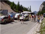
From Kranjska Gora we drive towards Bovec or vice versa, but only to the Vršič pass, where we park.
Route description:
From the parking lot at the Vršič pass we head onto the initially poorly marked path that leads to Mala Mojstrovka and Slemenova špica. After a short ascent the path brings us to a larger rock on which we notice the inscription Mojstrovka left. We continue in the direction of Mojstrovka (right Mojstrovka via Hanzova pot and Slemenova špica) along the path that ascends transversely through a sparse larch forest. After about half an hour of ascent the path brings us to an extensive scree slope below Mojstrovka. We cross the mentioned scree slope on the upper side, after which the path leads us into a crumbly gully. This is followed by a steep ascent over scree that is dangerous due to the risk of slipping, which we cover in about 15 minutes. At the top of the gully the steepness eases and the "sunny" coastal side opens up before us. Here the path turns right and after just a few steps begins to ascend steeply (danger of slipping in snow and ice!). At the top of this ascent we step onto a beautiful viewpoint, from which a nice view opens down towards Vršič. The path ahead moves slightly left from the ridge and then crosses two smaller gullies. A little further on the path approaches the ridge again. For the continuation of the path we have two options. We can continue straight on the marked path, which brings us to the summit over scree, or we can continue slightly right and continue the ascent along a beautiful panoramic ridge. The latter path is not marked but is much easier for the ascent, as we don't have to walk on scree. A little below the summit both paths merge and lead us to the summit register box, which is located a little below the summit and then to the panoramic summit of Mala Mojstrovka.
Vršič - Vratca pod Mojstrovko 1:00, Vratca pod Mojstrovko - Mala Mojstrovka 1:15.

Along the route: Za Šitom (1760m), Pod Vratci (1895m), Vratca pod Mojstrovko (1941m), Odcep v Veliko dnino (2033m)
Photos:
 1
1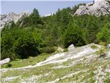 2
2 3
3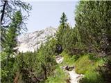 4
4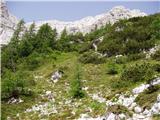 5
5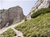 6
6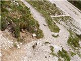 7
7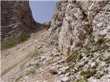 8
8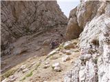 9
9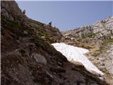 10
10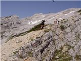 11
11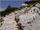 12
12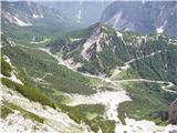 13
13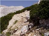 14
14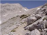 15
15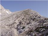 16
16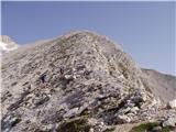 17
17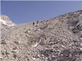 18
18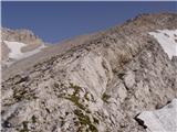 19
19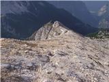 20
20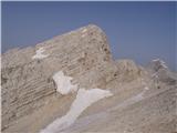 21
21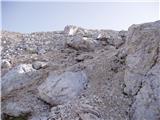 22
22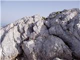 23
23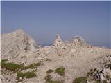 24
24
Discussion about the trip Vršič - Mala Mojstrovka (southern way)
Show older messages
|
| ROBERT22. 08. 2006 |
Worn path from hiking boots! Who is the owner of two forgotten inner parts of crampons?
|
|
|
|
| mt2. 10. 2006 |
MT - The path through the hole towards the notch has slipped even in dry weather. We can use prepared anchors. The path from the notch upwards on scree is unpleasant. I recommend the lowest path to the saddle between m. and v. Mojstrovka then right to m. Mojstrovka. Views superb. Descent on scree quick and pleasant. Even the hole under the notch (under Grebenc) is easier downhill. Markings on the ridge quite sparse. Recommend footwear you don't mind damaging.
|
|
|
|
| Gost31. 12. 2006 |
the path is really interesting. I recommend it to everyone who loves nature, beautiful views and peace. (and knows how to use a helmet, karabiners, rope, ...)
|
|
|
|
| majdicst13. 02. 2007 |
In the notch it's really a bit tricky, especially downhill, otherwise the only problem is the heat (in summer), since you're on direct sun the whole way - except in the notch. But that's why the descent on scree on the way back is eeeeeeeenjoyableeeeeeee Zoom, and you're at Vršič! Zoom, and you're at Vršič! Who will clean the shoes now? Who will clean the shoes now?
|
|
|
|
| Gost18. 05. 2007 |
On Sunday I'd like to climb Mojstrovka. What is the trail like?
|
|
|
|
| Gost26. 05. 2007 |
I'm interested in the snow conditions on Hanz's path in the north face. Is it already passable with summer gear?
Miha
Reply to email mich.5055@gmail.com
|
|
|
|
| Cbillabong9. 07. 2007 |
On Saturday 7.7.2007 I conquered it with my colleague. It was indescribable. We ascended via Hanzova pot. Descent we did on the other side so we nicely completed a loop. The ascent is quite demanding and requires a lot of caution, helmets are of course mandatory. Fortunately we were among the first in the wall behind us almost a whole bus
|
|
|
|
| Gost29. 07. 2007 |
When descending the scree, stick to the left. If you head right, you'll spend quite some time getting out of those junipers
Good luck!
|
|
|
|
| Nickster21. 07. 2008 |
When I went there were crazy crowds. There were lots of foreigners. Otherwise it was really good
|
|
|
|
| alpino piccolino31. 08. 2008 |
Yeah, it's not a bad thing this stuff, folks gather for schnapps. For the descent go to the dragon there over the scree, it's worth it just for that!!
|
|
|
|
| nejc*31. 08. 2008 |
little alpine... see you in 14 days we're going up together on Sunday.. then also gas down the scree..
|
|
|
|
| Everest20. 01. 2009 |
was last weekend in very bad weather. But very nice . .
|
|
|
|
| heinz27. 06. 2009 |
I agree with the predecessors regarding the necessary caution during the descent near (above and below) the škrbina, mainly due to scree and somewhat due to the damp ground. Slowly you get there (to the hut with a whole head).
I consider the trip not suitable for people without experience, or some knowledge of safe movement in the mountains. (just today we met a group of badly frightened housewives)
I think Mojstrovka is among the first mountains where the most inexperienced people go, thinking it's a simple mountain hike. The reason is the frequent location - proximity to the popular mountain pass and in my opinion even some too brief descriptions on websites that mark Mojstrovka as one of the most popular (especially due to the high starting altitude), easily accessible 2000ers in the Julians.
If that's the case, why do we then meet tearful faces on the trail?
Hribi.net would deserve even more visits and praise for its objectivity regarding trail descriptions and comments!
|
|
|
|
| vv27. 09. 2009 |
Flory now please write in Slovenian too.
|
|
|
|
| lepenatka27. 09. 2009 |
How could you miss Hanz's path, Flory?!
|
|
|
|
| Kozorog27. 09. 2009 |
Flory... I take this forum seriously but are you maybe joking a bit...???
|
|
|
|
| Petra Kalan17. 11. 2009 |
We plan to go up this weekend. What are the conditions like? Thanks for the info.
Best, Petra
|
|
|
|
| Parkeljc26. 01. 2010 |
Yesterday, Monday 25.1.2009 we set off for M. Mojstrovka. Weather in Kr. Gora foggy, light snow falling, increasingly dense fog towards Vršič. At the pass real winter; fog, wind, snow, cold, I even got frostbite for the first time this year. Conditions totally bad due to weather. At first we were looking for the start of the path, but found it only on the way back. Somewhere to halfway of the scree, about 300 m altitude, the weather was the same, then we climbed above the fog, the complete opposite, in short we stepped into another world, windless, sun, clarity, pleasantly warm,.. In a good two hours we reached the summit, where it was still breathlessly sunny. After enjoying the beauties that protruded from the fog all around, we returned to reality, to fog, wind, snow and cold. The path is nicely trodden, it starts somehow right behind the little house on the right, before descending the road towards Primorska. Crampons were not needed. The road is drivable only with winter tires. Wonderful trip!
|
|
|
|
| JusAvgustin28. 03. 2010 |
Where to jump on such a nice day? And greet muco too... Plan was actually to traverse the ridge of MM to Travnik, but conditions weren't safe, as under VM it started sliding the whole length and we turned back... Up the beginner's route , down the southern path. Butt wet from the gate almost to the road. Snowing on top, floundering on return, good training..., quite a few people, also foreigners, Vršič full, some touring, others on foot. To VM you can get from the other side, much safer. Enjoyed robi, matej(not grs!), juš , down the southern path. Butt wet from the gate almost to the road. Snowing on top, floundering on return, good training..., quite a few people, also foreigners, Vršič full, some touring, others on foot. To VM you can get from the other side, much safer. Enjoyed robi, matej(not grs!), juš
|
|
|
|
| tnt00717. 08. 2010 |
Last week we were at the top. Beautiful hike, suitable also for children who already know how to walk properly in the mountains, especially because of the scree. Running on the scree is unique, I highly recommend the hike.
|
|
|
|
| BlueAngell27. 08. 2010 |
On Thursday 26.7.2010 I went to the mountains for the first time in my life (until then I had only admired them from below) and chose this path,... and I have to say, I enjoyed it maximally, especially the view from the top is indescribable, I then continued the path to Velika Mojstrovka, where a nice view opens to Jalovec and Mangart,... in short, I spent a nice day, and I strongly recommend it to those going to the mountains for the first time to choose this path . lp . lp
|
|
|
|
| heinz27. 08. 2010 |
Last year I wrote about encountering a group of tearful, completely frightened and exhausted "hikers" who asked me/us if they could descend with us. Their legs were shaking like a reed in water, and mentally they were completely down.
This is the truth and I assure you I'm not exaggerating at all.
(People are very different after all)
Therefore, to those going to the mountains for the first time, let's suggest only easy paths! And if they should be paths to two-thousanders, let them be e.g. Stol, Debela peč, Viševnik etc..
|
|
|
|
| BlueAngell29. 08. 2010 |
heinz I sign under this,...well I intended to say that if they're already heading to Mojstrovka, they should go via the southern path, because it's easier than Hanz's path, where you literally have to climb the wall,...of course with the right equipment, because during the descent I noticed many tourists wearing sneakers and the like,...then injuries happen, not to mention the worst
|
|
|
|
| heinz29. 08. 2010 |
BlueAngell, this is where the discussion about the southern path is taking place. No mistake..
|
|
|
|
| oakley11. 08. 2011 |
Can you go up with a dog?
|
|
|
|
| turbo11. 08. 2011 |
Suitable for a dog, but rocky - watch for paw pad injuries and southern slope - heat = water! I've often met dogs up there, even in winter.
|
|
|
|
| Enka5. 09. 2011 |
I'm wondering if this more demanding part of the trail (steep scree ascent) is more strenuous and dangerous than e.g. the final section of the Italian route to Mangart (between the cables and the summit)?
|
|
|
|
| neph5. 09. 2011 |
I don't remember the paths to Mangart exactly, but there is no particularly dangerous section on the southern path. Caution is needed though. I only descended the mentioned path and it was very monotonous and strenuous for me, but that's just my subjective opinion.
|
|
|
|
| Enka9. 09. 2011 |
Neph, thanks. What Heinz mentions gave me a bit to think about, although based on everything read about this path, we probably really shouldn't have problems. But we are always careful.
|
|
|
|
| heinz10. 09. 2011 |
Enka, I was writing solely about the case >first time in the mountains<.
|
|
|
|
| sodnick29. 03. 2012 |
Does anyone know how much snow is left on Mala Mojstrovka?
|
|
|
|
| IgorZlodej29. 03. 2012 |
Too little for stellar skiing, unfortunately.
|
|
|
|
| turbo29. 03. 2012 |
@Igor
If it's not even worth a star  but some nonsense would do but some nonsense would do
|
|
|
|
| sodnick29. 03. 2012 |
I meant a hike, not skiing so no problem. Winter gear will be in/on the backpack anyway.
|
|
|
|
| nata929. 03. 2012 |
I went up the southern route to the summit (Saturday 17.3), thaw up to the saddle; at the saddle where the shady side is, still very icy - you need crampons.
|
|
|
|
| Branee29. 04. 2012 |
Any news on this path (conditions)? For May 5-6?
|
|
|
|
| Ajda_Zitnik29. 07. 2012 |
I walked the path today. The path itself is fairly okay, but great caution is needed in that part of the path "steep ascent on scree" before the view opens to Primorska.
Compared to the last part of the Italian path on Mangart, I'd say it's maybe a bit less "worn", than the path on Grebenc to Mala Mojstrovka, at least that was my feeling. Definitely requires careful and sure steps.
|
|
|
|
| Nancy19. 08. 2012 |
I'm wondering what's the best way to get from Mala Mojstrovka to Velika and which path do you recommend for the return?
|
|
|
|
| Gurenski pohodnk22. 10. 2012 |
We hiked the trail last weekend and it definitely pays off, carefully of course, to descend via the scree, as the pleasure is unique, and the trail is shortened time-wise. Good luck
|
|
|
|
| ZoranV19. 05. 2013 |
Mala Mojstrovka - descent to Drevesnica. The upper part is still excellent, the lower one is rock n'roll through scree and rubble. You can drive up to about the height of Vršič or a few meters lower. Of course there are a couple of interruptions in between.
To end the day, a quick descent from below Vitranc to Kranjska Gora.
A few snapshots from Mojstrovka and Kranjska Gora in the video:
https://www.youtube.com/watch?v=4CtKSe_7f6k
|
|
|
|
| ljubitelj gora8. 07. 2013 |
The trail is dry, trail through the gully, hard packed sand, yesterday one turned back just before the gully. Trail maintainers, markacists could improve the trail in the gully area and above the gully, when the view opens to Mojstrovkas, BG.
|
|
|
|
| asvi16. 07. 2013 |
Hello, I'm wondering if the path is also suitable for a dog?
|
|
|
|
| Daaam16. 07. 2013 |
Depends on the dog.. if it's used to walking on rocks then it will be fine... personally I've already seen a couple of dogs on Mojstrovka.
|
|
|
|
| malimiha5. 08. 2013 |
if the dog is used to it there's no problem. I was up there with a dog so it's doable
|
|
|
|
| scorpio23. 08. 2013 |
Today on M. M. a huge crowd... but what heated me up the most today is that people without any gear are wandering on these crumbly screes. With my colleague, we met two Czechs struggling in Allstars, and a family with children, where the youngest was wearing a huge father's sweater so that no arm was visible. I can't even imagine how she would catch herself if she fell. I know it's pointless to talk about supervision at Vršič... but still. Places where you drive high by car (and thus a large number of Sunday hikers every day of the week) maybe strengthen the warnings? I'm not smart enough, but I think accidents are still few. Especially when I think that we encountered a girl in sandals on the last slope below the summit...
|
|
|
|
| Ruzowski25. 10. 2013 |
Has anyone been to the Mojstrovkas this week? Any snow?
|
|
|
|
| Grega9226. 10. 2013 |
I was there on 19.10, no snow on the southern path, just a little on the summit
|
|
|
|
| robi1424. 07. 2014 |
The southern path is completely dry and without special features.
I was up there on 19.7. and watched the sunrise. Wonderful!
|
|
|
|
| slavkovoda8. 08. 2014 |
Today finally a real summer day, blue sky, real "šajba", gravel on the path ohoho too. On return a whole column of younger folks without poles, in sneakers, already halfway flushed in the face.....Later heard that police were active on M.Mojstrovka and Prisank. Correctly!
|
|
|
|
| Zebdi8. 08. 2014 |
Since when are poles mandatory equipment?
|
|
|
|
| slavkoo9. 08. 2014 |
Just saying what I saw... Are hiking boots mandatory equipment, smarty-pants?
|
|
|
|
| VanSims9. 08. 2014 |
For such a path as the descent on the normal route from Mojstrovka, poles would almost be mandatory equipment.
Otherwise, no equipment is mandatory, but it only takes a moment to realize that you should have had them, and that moment might be too late. The police should anyway have the authority to remove people from the path and fine violators. At least those who endanger others with their lack of equipment.
And if rescue is charged or if one must insure for the case of an accident (gross negligence is a reason for the nullity of the insurance policy), then there will be order in our mountains!
|
|
|
|
| slavkovoda9. 08. 2014 |
Just an addition to this last topic: look at the newspaper Dnevnik, Saturday 9.8., page 10, bottom left title: 60 Czechs in sandals on a two-thousander. I wrote about this yesterday. End of debate!
|
|
|
|
| Zebdi9. 08. 2014 |
slavkovoda, I agree with that of course. Running up there in sandals is foolishness. Low shoes with hard soles are certainly a much better option (which alpinists often use during descents), but high mountain boots are by far the best. But poles are really a personal choice - if someone has knee problems, they should of course use them, but for me in summer they are more of a hindrance than a help...
|
|
|
|
| maui26. 12. 2014 |
Has anyone gone on this path in the last few days? What's the condition?
|
|
|
|
| veja526. 12. 2014 |
The day before yesterday was on Mala Mojstrovka. Snow conditions. Recommend crampons, ice axe, helmet - in short equipment and knowledge for winter conditions.
Greetings! Venčeslav.
|
|
|
|
| stilc8828. 05. 2015 |
Maybe someone knows how much snow is left opposite Mojstrovka to Mojstrovka?
|
|
|
|
| Ruzowski31. 05. 2015 |
The path has no special features.
|
|
|
|
| bregar073. 11. 2015 |
Anyone know what the conditions are like up there? My buddy and I plan to go up this Thursday/Friday, depending on the weather. Is the southern path dry?
|
|
|
|
| jedriličar4. 11. 2015 |
The southern path was completely dry already on Sunday. There is some snow in the north wall if you go to MM from the NŠG side (above the exit from Hanzova there is one snow patch, and some snow remnants in the wall), and also some snow in the wall on the ascent to VM and on the ridge towards ZM. For an experienced mountaineer this snow is no problem for the ascent. Good luck
|
|
|
|
| natalia2319. 05. 2016 |
Hello..., I'm interested if anyone has any latest information regarding conditions on the path to Mala Mojstrovka..., thanks for any reply and take care...
|
|
|
|
| Grenaleva19. 05. 2016 |
Some were there on 14.5., that section from Vršič up is all in snow and they walked with ice axes
|
|
|
|
| cybom6. 06. 2016 |
Has anyone been to the summit via the southern route? Is there still any snow or is it clear already?
|
|
|
|
| 75'er6. 06. 2016 |
There was still some last weekend, so I doubt it's gone already.
|
|
|
|
| Čmrljček 76. 06. 2016 |
I was there on Saturday via this trail to Mala and Velika Mojstrovka and the trail is almost completely dry, bare and normally passable. Before the gully you need to cross two short snowfields which pose no problems. On the ridge there's also one small snowfield, but you cross it nicely without issues. You don't need winter gear on this trail.
From Mala towards Velika Mojstrovka there's a larger snowfield, snow accompanies you all the way to the top, the summit is completely bare and dry. Here it's advisable to have an ice axe, crampons for the less experienced... but you can manage without this gear, just need to be a bit more careful when walking...
Best regards.
|
|
|
|
| obiskovalec1221. 07. 2016 |
Hello,
I'm interested if this trail can be hiked also by less experienced mountain visitors. I'm talking about a group that is not fully equipped (just good sneakers and no helmet) but really wants to make the most of their day in the mountains.
Could someone share advice?
And also, if you don't recommend this trail, can you suggest some interesting and not too demanding trail from Vršič to nearby 2000ers? I already know Slemenov vrh, is there anything similar?
Thank you for the response.
|
|
|
|
| Meri1121. 07. 2016 |
Footwear is not even the most important.
More important is how much stamina they have.
It is quite steep. And so that the sun doesn't scorch you.
Similar is Prisank (south), maybe a bit harder
|
|
|
|
| Meri1121. 07. 2016 |
Starting points for nice and not too demanding trails are in the Zadnjica valley.
Kriški podi, Prehodavci, Dolič
|
|
|
|
| Smetar21. 07. 2016 |
The south to M. Mojstrovka is not so demanding in terms of stamina... (700m ascent at a slow pace almost anyone can manage)
The scree on the path can pose problems...
|
|
|
|
| jax21. 07. 2016 |
Ah, no, no need to exaggerate ... yes, definitely, this trail is quite suitable also for inexperienced hikers. Just be careful in the gully, on the rest there are absolutely no problems.
As for stamina - surely the trail is a smaller challenge than Kriški podi or Prehodavci from Trenta ...
|
|
|
|
| B221. 07. 2016 |
Yes, to Kriške pode from Zadnjica valley is 3 hours, to Prehodavci also 3 hours and to Dolič the same. It cannot be compared at all to an hour and a half walk to Mojstrovka. But we wouldn't talk about the south trail to Prisojnik - 4 hours of walking in direct sun...
|
|
|
|
| Meri1122. 07. 2016 |
For me, Mojstrovka "fell harder" due to the crumbly terrain combined with steepness, and perhaps also because it was November.
To Kriške pode, Prehodavce and Dolič, beautiful zigzag mulatieras lead, which is much easier for walking, despite longer time.
Visitor12 says they would spend the whole day in the mountains and are inexperienced. I cheer for Kriške pode (lake, edelweiss..).
|
|
|
|
| simon7922. 07. 2016 |
visitor, briefly:
- fitness-wise not too bad (especially compared to Prisankom, Doličem, Prehodavci as meri11 mentions ??)
- in the gully helmet recommended + caution
- further towards the summit (or even more back) - problem is a lot of scree on smooth rocks. Even with hiking boots a lot of caution was needed, quickly you end up on your butt
Good luck!
|
|
|
|
| Becar22. 07. 2016 |
You don't hike this path or other high mountain paths in sneakers. Rescuers always warn about this, yet such questions
|
|
|
|
| Limopilo3. 06. 2017 |
Hello,
Has anyone gone along the southern path in the last few days? What's the condition?
|
|
|
|
| mito30003. 06. 2017 |
I was there on Thursday, 1.6. - no snow on the path anymore. But there's still quite a bit of snow towards Velika Mojstrovka.
|
|
|
|
| Shkaro16. 11. 2017 |
mountain lover the link is incomplete so I can't see the pictures, but I'm sure everyone would like to see them
|
|
|
|
| ločanka16. 11. 2017 |
See current conditions below
|
|
|
|
| ljubitelj gora29. 01. 2018 |
Vršič - Butinarjeva grapa - Mala Mojstrovka - Pripravniška grapa, top conditions, great for crampon descent 28.1.2018
[img]http://shrani.si/f/32/7M/3TvivIj2/img3503.jpg[/img]
[img]http://shrani.si/f/3A/ah/2DpxD37u/img3517.jpg[/img]
[img]http://shrani.si/f/1z/CD/4GBpAIz6/img3541.jpg[/img]
[img]http://shrani.si/f/1X/KY/26RHzxRn/img3554.jpg[/img]
|
|
|
|
| nejcf15. 08. 2018 |
Today we ascended Mala Mojstrovka via this path. As usual in recent years, crowds gathered at Vršič early in the morning. There were huge numbers on Mojstrovka too. The quick descent over scree was really pleasant.
|
|
|
|
| kekec127. 09. 2018 |
The upper half of the ascent - from the upper edge of the bushes to the summit - is not marked. There through the scree everyone looks for sections that slip the least. If you traverse this upper part along the ridge, there is less scree, mostly you can step on stable rock, but in places you have to walk close to the precipitous edge. The alternative is to walk a few dozen meters below the ridge through the mentioned coarse scree that rolls over a base of steep slabby rocks. The label "partly demanding path" is justified. Children and beginner hikers can easily get injured due to slipping, especially when going downhill.
|
|
|
|
| georgia27. 07. 2019 |
We descended this trail, which is really crumbly and full of gravel. It slips even with good mountain boots, and we met a huge number of tourists in sneakers, even with smooth soles, which are for the city and not for mountains, let alone such trails!!! They were slipping already on the way up, the path through the notch was catastrophic because of such sights and dislodging stones...
We warned someone about inappropriate footwear, as he was barely climbing up, but he just thanked and continued anyway. How he and others similarly shod (some with children in carriers) even got up and down, I don't understand. Obviously they have more luck than sense...
Still, we chose a shortcut through the scree and hoped no one triggers a stone on us. You have to stick to the left side, we just in time corrected the direction right through the bushes. Great shortcut!
|
|
|
|
| Anja00716. 08. 2019 |
Yesterday I hiked this trail and extended it to Velika Mojstrovka. In the morning it was still nice because there weren't many people, but when we returned around 10:00 - 11:00, there were really a huge number and sometimes we had to wait.
The trail is fun, sufficiently varied and not overly demanding in terms of fitness or technically. But there is really a lot of scree where the bushes end. Additionally, in the upper part along the ridge and below the ridge there are quite a few "trails" and in my opinion a helmet is mandatory, because a stone can fly quickly or you can awkwardly fall. And of course extra caution because the legs are already a bit tired.
I really don't understand people who tackle this trail in Teva sandals or Airmax sneakers.
Even though it's "only" 700m elevation gain and the trail is marked as partially demanding, a fall and serious injury can happen very quickly. Not to mention that the bare feet in sandals probably suffer on that scree.
Use your head, helmet on head and boots on feet!
|
|
|
|
| solsticij14. 06. 2020 |
The fixed cable in the notch is in quite poor condition, two pegs are missing and one will soon fall off.
|
|
|
|
| monika899517. 08. 2020 |
Today at 6:45 started the path from Vršič to Mala Mojstrovka via the southern route. Fog accompanied us the whole time, which made orientation difficult on the second half of the path to the summit, and likewise from the summit to the valley. Wire rope and pitons are in good condition.
|
|
|
|
| Lazo4. 09. 2021 16:54:59 |
Here's a video if anyone wants to see the path to Velika Mojstrovka and then the traverse to Mala Mojstrovka.
https://youtu.be/ndLKIWRZF08
Safe steps to all!
|
|
|
|
| BorStenar20. 11. 2022 09:52:48 |
About a month ago I was at Mala Mojstrovka. For ascent we went over scree under western ridge (very crumbly), descent over scree between Mala and Velika Mojstrovka (trodden path). Approaches join at smaller saddle (not Vratci between Mojstrovkas and Gumnim, but where path goes to scree under it). View excellent, tour too.
|
|
|
|
| BorStenar4. 12. 2022 15:40:16 |
Besides, there was no snow
|
|
|
|
| Matija G10. 09. 2024 18:08:35 |
Today I descended from Mojstrovka via the southern trail, and I have to say I wondered if the description "marked trail" still matches the actual condition. I did start the descent closer to the ridge, but eventually ended up on the right trail at the bottom of the valley, but it was quite poorly marked. The markings are mostly very poorly visible; it looks like a lot of water has flowed since the last renovation. Most hikers simply look for the best passages themselves both on ascent and descent.
|
|
|
|
| di22. 09. 2025 20:48:51 |
Is the passage through the gully secured in any way (e.g., with a cable)?
|
|
|
|
| asdf23. 09. 2025 00:43:35 |
The cable runs along the entire upper part of the gully. The lower part, which has no cable, is less steep.
|
|
|
To post a comment you must log in:
If you do not yet have a username, you must first
register.