Vršič - Prisank / Prisojnik (ridge way)
Starting point: Vršič (1611 m)
| Latitude/Longitude: | 46,43360°N 13,74350°E |
| |
Route name: ridge way
Walking time: 3 h 30 min
Difficulty: very difficult marked way
Elevation gain: 936 m
Elevation difference along the route: 1000 m
Map: TNP 1 : 50.000
Recommended equipment (summer): helmet, self belay set
Recommended equipment (winter): helmet, self belay set, ice axe, crampons
Views: 127.035
 | 11 people like this post |
Access to starting point:
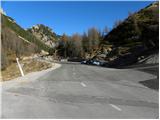
From Kranjska Gora we drive towards Bovec or vice versa, but only as far as the Vršič pass, where we park.
Route description:
From the parking lot we head onto the road in the direction of Trenta and at the end of the parking lot we reach a small intersection, where we continue left onto the side road, which after a short ascent takes us to Tičarjev dom na Vršiču.
From Tičarjev dom we continue along the gravel road next to which there are signs for Poštarski dom and along which we begin to ascend moderately over scenic slopes. With views of the surrounding peaks, we quickly reach a marked junction.
Here we continue right in the direction of Prisank and Razor (straight on the road to Poštarski dom and the summit of Vršič) and continue on a well-trodden mountain trail, which for some time continues along a gentle and scenic ridge. After a few minutes the path begins to ascend more steeply through a sparser belt of dwarf pines, then it levels out and takes us right below the summit of the grassy Sovna glava.
From Sovna glava follows a short descent to Sedlo za Sovno glavo and we are already at the next junction, where we continue straight or slightly right (left leads the path to Prisank through Prednje okno). In the continuation we cross the slopes on the western side of Prisank or Prisojnik over scree. The path ahead ascends a bit more and takes us to a place where the Grebenska pot to Prisank branches off to the left, while straight ahead continues the path that leads to Razor, Pogačnikov dom and Prisank (Prisank - Southern or Slovenian path and Jubilejna pot).
From the junction we head onto the Grebenska pot, which continues along the southern slope just below the ridge of Prisank. The path ahead leads us over a very steep slope and is especially dangerous for slipping when wet. Higher up the path turns slightly to the right, and from the left we are joined by the path that leads through Prednje okno (Kopiščarjeva pot).
The window which we see on our left side (below us), we bypass on the right side, and the path above the window becomes technically more demanding. The path in the continuation runs along an exposed ridge, and we are helped by fixed ropes that help us advance more safely. After some time the difficulties ease a little, but the danger is not over yet, as we walk along the ridge all the time, which is in places very exposed. A little below the summit the path moves away from the ridge onto the southern slopes, where other paths join us from the right (Slovenska pot, path over Kajzljeva škrbina and Jubilejna pot).
Here we continue left and only a short ascent to the very panoramic summit follows.
We can descend via the easier Slovenian path.
Vršič - razpotje pod Bavho 0:15, razpotje pod Bavho - Sovna glava 0:15, Sovna glava - Sedlo za Sovno glavo 0:05, Sedlo za Sovno glavo - Gladki rob 0:25, Gladki rob - Prednje okno 1:30, Prednje okno - Prisojnik 1:00.

The trip can be extended to the following destinations: Križ
Photos:
 1
1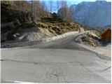 2
2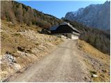 3
3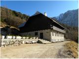 4
4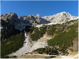 5
5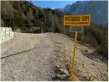 6
6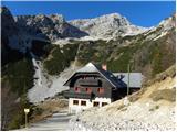 7
7 8
8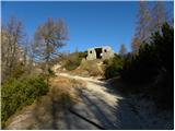 9
9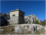 10
10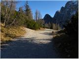 11
11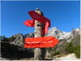 12
12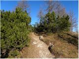 13
13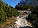 14
14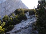 15
15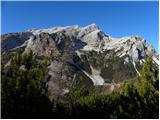 16
16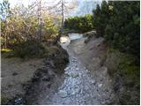 17
17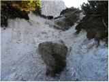 18
18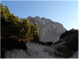 19
19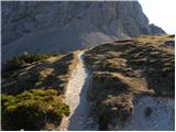 20
20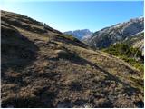 21
21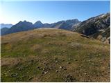 22
22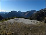 23
23 24
24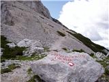 25
25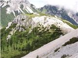 26
26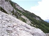 27
27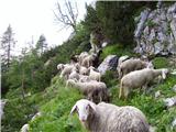 28
28 29
29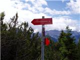 30
30 31
31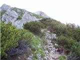 32
32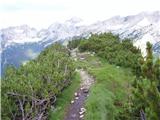 33
33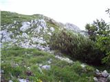 34
34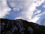 35
35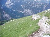 36
36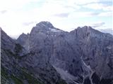 37
37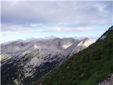 38
38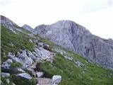 39
39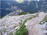 40
40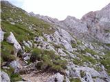 41
41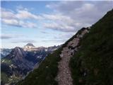 42
42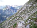 43
43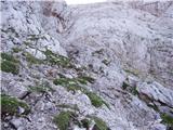 44
44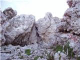 45
45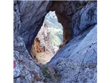 46
46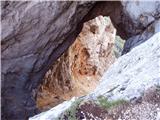 47
47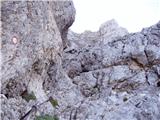 48
48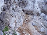 49
49 50
50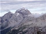 51
51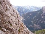 52
52 53
53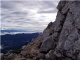 54
54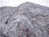 55
55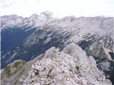 56
56 57
57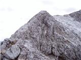 58
58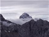 59
59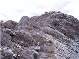 60
60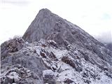 61
61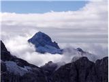 62
62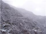 63
63 64
64
Discussion about the trip Vršič - Prisank / Prisojnik (ridge way)
Show older messages
|
| Gost29. 07. 2006 |
Wonderful exposed ridge - of course in good weather!
|
|
|
|
| Gost26. 12. 2006 |
Unforgettable adrenaline trail from the top of Prisojnik. Better up, then down the southern valley.
|
|
|
|
| Gost13. 09. 2007 |
where is Hanzova pot "Tez hudičev steber"
|
|
|
|
| Gost22. 09. 2007 |
I'm wondering if there's any snow up there, because I'd like to climb up on Tuesday??
What do you advise?
Thank you very much!
|
|
|
|
| Gost23. 09. 2007 |
There's some snow, but no panic. Just a bit more caution is needed.
|
|
|
|
| Kuba26. 09. 2008 |
Wow....this is wild...no money to go up here..I believe it's a crazy experience for those who enjoy it....but this is really too wild for me even on pictures..let alone live
Are there any harder paths here to see even more "horrible" pictures)
|
|
|
|
| NEIC00826. 09. 2008 |
Is there an easier one???
|
|
|
|
| 5Xum11. 07. 2009 |
Nice greeting, I have a question. How does this trail compare to the ascent of Grintovec via Frischauf path? Is it much more demanding?
|
|
|
|
| knap422712. 07. 2009 |
Physically less demanding, but regarding the difficulty itself, it's somewhat easier in my opinion. If you managed Grintovec via this path, I think there won't be problems here either. LP
|
|
|
|
| novinsekp2. 08. 2010 |
Yesterday my husband and I were on Prisojnik via Grebenska ascent and southern descent. Weather fantastic, quite a lot of people, trail dry (no snow, except some patches that do not hinder access).
|
|
|
|
| ljubitelj gora26. 09. 2010 |
This week when the weather was nice I did this path to Prisojnik, I must say you have to be really careful not to stray, as there's a precipice just a bit off. Markings are enough, but you have to watch. Up via Slovenska pot, down the ridge. Triglav seemed easy compared to this path to Prisojnik.
|
|
|
|
| alenkas13. 07. 2011 |
hey! next weekend going with husband to Prisojnik. haven't chosen the path yet. interested in how demanding the ridge path to Prisojnik is - more or less than the one from Špica to Jalovec?
|
|
|
|
| andrej7813. 07. 2011 |
The path to Jalovec is incomparably more demanding, on the ridge to Jalovec only the upper part at the ridge crossing is tricky.
lp
|
|
|
|
| JusAvgustin13. 07. 2011 |
but Hanzova is another story...
|
|
|
|
| skalar5013. 07. 2011 |
this morning summit (view) more or less invisible - gusts of fog and wind. but still fairy-tale like, very few visitors.
|
|
|
|
| marjana061115. 08. 2011 |
Yesterday at noon the summit in perfect clarity, wonderful view far around. Three of us went to the high mountains for the first time ever, without any problems, with a guide, but it's true that we are in good physical condition. We recommend the path up along the ridge, down along the easier Slovenian path. It's worth it!
|
|
|
|
| matz23. 08. 2011 |
I'm interested in how this path is secured? Can you protect yourself with a via ferrata set everywhere on exposed sections?
|
|
|
|
| ruševec26. 08. 2011 |
On Wednesday I walked this path. I can say that almost all the hardest spots seemed well protected to me. At least in the lower part from the window to the ridge there are really plenty of fixed protections. On the ridge itself, here and there you really need to grab the rock too. For this path, an experienced mountaineer in normal conditions in my opinion does not need a self-belay kit. No one else on Wednesday on this path was belayed and I was the only one with a helmet. Matz if no excessive vertigo, then the ridge path shouldn't be a problem. If it's meant for someone who is a complete beginner on very demanding paths, then better go via the Slovenska - southern path.
|
|
|
|
| BT8826. 08. 2011 |
Hi. Matz complete belay kit and helmet are mandatory on this path as well as hribovski shoes. The summit ridge is in places poorly protected and exposed so for an inexperienced hiker we recommend accompaniment by an experienced mountaineer if necessary in a rope team.
Good luck.
|
|
|
|
| Parkeljc26. 08. 2011 |
"matz" more or less it's all in the head (except the helmet, which is on it)
|
|
|
|
| Okmodko26. 08. 2011 |
The path isn't that dangerous. But it's nice that it's secured.
|
|
|
|
| ic7. 09. 2011 |
Is anyone going this weekend (Saturday) over the ridge to Prisojnik? I'd join since it's my first time. lp
|
|
|
|
| Janiel741. 10. 2011 |
I'm wondering if this is actually the path called "mimo Prednjega okna" in the Planinski vodnik? Thanks
|
|
|
|
| ŠpRo291. 10. 2011 |
That is the Kopiščarjeva pot.
|
|
|
|
| ŠpRo291. 10. 2011 |
I.e. on Kopiščarjeva you go through prednje okno
|
|
|
|
| Janiel741. 10. 2011 |
This is not the same
|
|
|
|
| garmont1. 10. 2011 |
Kopiščarjeva pot leads through Prednje okno, Grebenska pot leads past Prednjega okna. These are two different paths that merge above the window into one - Grebenska pot.
Regards
|
|
|
|
| Janiel741. 10. 2011 |
Can you compare the difficulty with MM, Slovensko na Mangart, Koroška Rinka?
|
|
|
|
| garmont1. 10. 2011 |
Compared to the above three, Grebenska pot is easier - quite a bit. Apart from exposure on the ridge, there are no major difficulties. For me the hardest spot was perhaps right above the window (about 5 minutes), where the ground is unpleasantly loose and the path turns steeply right around the rock edge. Then classic ridge path to the summit.
Regards
|
|
|
|
| Janiel742. 10. 2011 |
Done with this path... wonderful weather, the path is very scenic, some climbing in between, and at the end along the ridges that really pass quickly Down via the southern path, which isn't uninteresting either! Next year via Kopiščarjeva
|
|
|
|
| Ajda_Zitnik6. 08. 2012 |
I hiked the trail yesterday. There is no snow on it at all, but I would warn that in my opinion the trail is not suitable for beginners, as it is quite exposed, and safety gear is installed only where absolutely necessary. Definitely not for those afraid of heights or people who think they might become dizzy.
You also need to watch the markers closely to avoid getting off track, as the ridge is exposed on both sides (as mentioned above), otherwise the rock is solid and not overly crumbly.
Regarding the path "past Prednje okno" - yes, you definitely go past it (Kopiščarjeva pot also joins this trail, leading through Prednje okno), but you do not go through it as on Kopiščarjeva pot to Prisank.
|
|
|
|
| Becar16. 08. 2012 |
On 12.8. I hiked the ridge path. Wonderful views, considerable exposure, the fixed protection is in good condition, but there's not an abundance of it either. Suitable up to the Window also as a family outing. For the first time I was at the Window itself and was fascinated by its size. On the ridge at 5°C and quite unpleasant wind I met a hiker without a shirt while the rest of us were freezing in our windstoppers. Some are hot-blooded. 
|
|
|
|
| alenkas17. 08. 2012 |
15.8. up the ridge, down the Slovenian valley. For me, that was quite enough adrenaline. At the summit there were already about 30 people by 10am. Weather phenomenal, views too.
Everyone we met - young and old - claimed that the ridge isn't anything special.... so the victory over myself was a bit less sweet.... because to me it seemed like there was a drop-off left, right, and behind me, good thing I kept looking only two steps ahead :-))
|
|
|
|
| Becar17. 08. 2012 |
Well... those who say that the mentioned ridge path is easy, they say it because of their own self-aggrandizement, boosting their ego above others and simultaneously crushing another hiker's ego, which is actually piggish, but unfortunately a very common phenomenon. I notice there's a lot of that in the mountains too, like getting to the summit faster than others or having a better car than the neighbor etc... So don't look too much at others, the completed path is a nice success, it's not for everyone, I've seen two Frenchmen and a Dutch family turn back, so looking at your feet instead of gawking around is no flaw, but responsibility. There will always be a path that's harder than another and even one that's harder than the capabilities of the most capable hikers.
|
|
|
|
| Kriška17. 08. 2012 |
Bravo Becar, I think you hit the nail on the head! :-)
|
|
|
|
| Keko17. 08. 2012 |
The ridge path is difficult for those afraid of deep views around them, otherwise it's not that dangerous. If someone asks me, I'd say the southern path is more dangerous and more accidents due to slips happen on it than on the ridge one, as many take it too lightly. Most have a bit more respect for the ridge path, which is right.
|
|
|
|
| Becar17. 08. 2012 |
I'd say as long as you don't slip, none is dangerous . A slip on the mentioned ridge would end in a flight even for those not afraid of depths at larger spots . My opinion doesn't matter much, more important is looking at books, maps, and ultimately the hribi.net portal, where technical difficulty, considerable exposure and dangers are mentioned. The path is categorized as very demanding in all sources of marked hiking trails and I have no objections. If someone remembers it as easy, that's fine too, but thank God it apparently doesn't apply to most of us - average hikers who visited it.
@Keko: maybe it would be good to consider the visitation of one and the other path and link it to the number of accidents?
|
|
|
|
| stefy17. 08. 2012 |
On Sunday I plan to ascend Prisojnik. So you suggest ascent via the Ridge Path and descent via the southern path? Thanks for the reply, lp
|
|
|
|
| jax17. 08. 2012 |
Becar - here I'd almost agree with Keko. I think visitation isn't a factor, as I feel about 75% of Prisojnik visitors do the ridge-southern combination, about 15% go via one of the more demanding ones and maybe only about 10% dare only the southern. My humble opinion is that there's no special difference in difficulty between the two. The ridge has that part above the window which is somewhat climbing, but well secured, key difficulties lie elsewhere anyway (scree, grassy slabs, exposure, unsecured parts). You have plenty of that on both paths, but I think more on the southern.
|
|
|
|
| jax17. 08. 2012 |
stefy: yes, that's the standard Prisojnik. If you don't dare one of the harder ones, this is the best.
|
|
|
|
| BibaS27. 08. 2012 |
On Saturday we ascended to Prisojnik via Grebenska pot in a pleasant and fairly large group (probably someone will recognize themselves ) and I must say that I really liked this path.
Definitely again to Prisojnik via some other path.
|
|
|
|
| oybl12. 09. 2012 |
Watch out for sheep on this trail. No joke, just below the window there was a herd of sheep above me that triggered a whole rockfall downward
|
|
|
|
| bostjanp12. 09. 2012 |
@bibas: yes, you're right. The path is very beautiful, even more so if the weather is nice and sunny. There were quite a few hikers on this path then, but towards the top our little group stretched out. At the top almost not enough space, because everyone was coming up from somewhere
Either Hanzova or Kopiščarjeva still awaits me too...next year.
|
|
|
|
| Mark Avrelij8. 07. 2013 |
We went on the trail on 6.7.2013 and I have to say it's great, there are some snow patches but they can be easily crossed. In short, a nice trip
|
|
|
|
| Suriljana26. 07. 2013 |
Are there still snowfields on the path?
|
|
|
|
| dlipusc119. 08. 2013 |
I went along the ridge to Prisojnik for the first time yesterday 18.08.2013, it's very demanding if it's your first time if you haven't done a few easier hikes before for fitness and other sensations. It's underprotected in certain places. Shame, there could be more visitors. Up was a bit harder, down via Slovenska was quite good. Best regards to all.
|
|
|
|
| Keko19. 08. 2013 |
When you go along it a second time in a year or so, I think you'll change your mind and find it just adequately protected.
|
|
|
|
| veja55. 09. 2013 |
Hi,
picture 25 shows the marker at Prisojnik window. Does this path join Kopiščarjeva and approximately where?
Thanks for the information.
|
|
|
|
| ben5. 09. 2013 |
This path takes you to the entry of Kopiščarjeva, i.e. to its beginning!
|
|
|
|
| jedriličar5. 09. 2013 |
This is at the saddle when you descend from Sovna glava, to the right you go to the ridge path, and this path left to Prisojnik window drops you down the scree to the entrance to Kopiščarjeva ... approx 100 m height descent ....
|
|
|
|
| veja56. 09. 2013 |
Thanks for the information.
Best regards to all!
|
|
|
|
| zupi17. 07. 2015 |
Does anyone perhaps know if there's still any snow on the mentioned path?
|
|
|
|
| zico1017. 07. 2015 |
Today I did the descent via the ridge and there's no snow.
|
|
|
|
| Suriljana8. 09. 2015 |
Is there still any snow on the ridge trail?
|
|
|
|
| vodenjačica5. 06. 2017 |
We passed the ridge trail on 4.6.2017. towards the top and it is passable with no snow or ice on the trail. Locally wet and slippery due to snow melt.
The Slovenian trail on descent is still snowy in the middle section, snow and ice height locally several meters, we crossed snowfields three times, ice axe and crampons mandatory and utmost caution required.
|
|
|
|
| donington10. 08. 2019 |
tomorrow I'm heading up, anyone coming? 040590682
|
|
|
|
| MitjaBelak16. 09. 2019 |
On Saturday 14.09.2019 first time and with great respect, up the ridge path, down the Slovenian one. To the window the path is without peculiarities, above the window where wire ropes help us, it's a bit adrenaline-pumping, especially for someone not used to such views or has issues with heights. Securing, I'd say is sufficient. The size of the window impressed me too, it's really big. Further along the ridge, the path shouldn't be underestimated either. On the way down quite a lot of loose scree, but easier. This is just my humble opinion. If I repeat, then in this direction. LP
|
|
|
|
| Ficla26. 08. 2020 |
22.8.2020 we went on this path, which is very well marked, we returned via the Slovenian one. The beginning is quite nice, for warming up. The path after the junction for the ridge path is quite steep. The window is really bigger than we imagined. Then the second part of the path begins, where we help ourselves with chains. The path is well secured, on some sections, especially along the ridge, a bit more caution is needed. Otherwise, the path is very nice and the views are wonderful .
|
|
|
|
| Tomaž0022. 06. 2022 06:07:26 |
Is any climbing needed up to the front window? I would take young hikers (15 and 13 years old) on the ridge path, thanks for the answer.
|
|
|
|
| mirank22. 06. 2022 08:58:29 |
To the window, even inexperienced hikers shouldn't have problems. Above the window it's somewhat more difficult but also well protected. For those with vertigo the hardest are a couple of unprotected spots on the ridge. Otherwise look more closely at the pictures above - good luck and sensibly, better to turn back if scared!
|
|
|
|
| jax22. 06. 2022 10:17:10 |
To the window? Little path. Further on it's quite exposed, though not even difficult. But to the window really no problem.
|
|
|
|
| Tomaž0025. 06. 2022 17:52:14 |
How long to the front window from Vršič, thanks
|
|
|
|
| Zajla46. 10. 2023 18:50:28 |
Can someone tell me what the current conditions are like for Prisank via the ridge path? I plan to go this Saturday.
|
|
|
|
| cen27. 07. 2024 20:15:45 |
Circular Vršič - Grebenska - Slovenska. The path is well secured, no serious exposure for experienced hikers really. Views phenomenal all the time.
|
|
|
|
| Piscanetz12. 08. 2024 21:31:22 |
Comparison of the Grebenska on Prisank with e.g. the ridge path on Storžič from Žrelo up - regarding exposure? Who can compare? In the past I have already gone via Kopiščarjeva (to the Window I have one of the best memories) and also Jubilejna ... but I simply don't remember the ridge from the Window up. The kid for example easily handled it on Storžič via Žrelo and I'm looking for a comparison
|
|
|
|
| lukecpukec13. 08. 2024 06:27:13 |
The Grebenska on Prisank has a few exposed sections where extra caution is needed. Most of it is a nice and "sufficiently" wide ridge path... but definitely not a stroll in Tivoli. If someone has gone through Žrelo to Storžič, they will probably manage the Grebenska on Prisank too...
|
|
|
|
| Piscanetz18. 08. 2024 19:35:50 |
That's what I thought. Thanks!
|
|
|
|
| GregaČ16. 11. 2024 15:41:11 |
We went on Sunday 10.11.24, nice sunny windless autumn day, ridge path up, Slovenian path down (circular route). The path definitely shouldn't be underestimated, prepare well for it and reserve enough time. Markings are quite well marked, so no issues there. No snow, but at the start of the path, around Sovne glave area, there was some ice because it's shady. We're not chamois by nature, so the path was quite strenuous and long for us, but nevertheless very beautiful. Up to the window no major demanding features, from the window onwards more demanding and very steep (not for vertigo sufferers). The ridge really drags, because at least 4 times you think you're at the top, but it's not yet. Several exposed sections, there could absolutely be a few more pegs or some more fixed ropes. Self-belay kit is definitely needed in our opinion, helmet too. At the top fixed stamp, need sponge and ink. We had signal most of the way (writing this for emergency call cases). Stunning view. We returned down in the dark - watched a beautiful sunset and returned to the car with lights. Lights I absolutely recommend too, because it can drag on quickly. We weren't the only ones returning down in the dark (i.e. after 6pm). Good luck and be careful in the mountains everyone!
|
|
|
|
| mirank16. 11. 2024 17:41:20 |
Also write when you started, so that 10 hours of daylight weren't enough for ascent and return from Prisojnik
|
|
|
|
| mjk19. 08. 2025 10:07:01 |
Regarding exposure.. The hardest part is right after the window, once on the ridge I don't even know where else SVK could be used. For the 2 cables, which are very steep though, let everyone decide for themselves if it's worth taking SVK along. Very nice path, well secured and marked. P.S.: comparison with the gully on Storžič ... Very similar, just the wall is bigger looking down.
|
|
|
|
| plaNinaPirsMajcen24. 09. 2025 18:21:33 |
Hi,
a few days ago we explored this path. I recorded the key parts of the path for those who haven't been yet and don't know what to expect.
https://youtu.be/VMF5DQEERFA?si=2TSlMCAWkDcBYFtB
It was an enjoyable ridge path for us, which from Prednje okno onwards offers scrambling along the ridge, secured at key points with pegs and cables. Two really narrow details (ridge narrower than one meter to step) can be safely bypassed a bit lower than the marked part. At least that's how we did it. It's wide enough and safe to step.
Views idyllic all the time, anyway the ridge passed quickly for us and we really expected it to be harder. I would advise against the path in wet conditions and with gusts of wind.
The Slovenska pot for descent is supposed to be easier, but we didn't like it much, as it's full of scree, rubble, every step needs care and it really drags... also some cables greet us, so there's no easy approach to Prisojnik.
And best regards from the mountains!
Nina
|
|
|
To post a comment you must log in:
If you do not yet have a username, you must first
register.