Vršič - Prisank / Prisojnik (Slovenian way)
Starting point: Vršič (1611 m)
| Latitude/Longitude: | 46,43360°N 13,74350°E |
| |
Route name: Slovenian way
Walking time: 3 h 30 min
Difficulty: difficult marked way
Elevation gain: 936 m
Elevation difference along the route: 1000 m
Map: Triglav 1:25.000
Recommended equipment (summer): helmet
Recommended equipment (winter): helmet, ice axe, crampons
Views: 233.430
 | 7 people like this post |
Access to starting point:
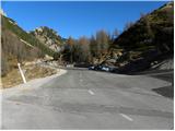
From Kranjska Gora we drive towards Bovec or vice versa, but only to the Vršič pass, where we park.
Route description:
From the parking lot we direct ourselves to the road in the direction of Trenta and at the end of the parking lot we arrive at a smaller crossroads, where we continue left onto the side road, which after a shorter ascent brings us to Tičarjev dom na Vršiču.
From Tičarjev dom we continue along the macadam road beside which there are signs for Poštarski dom and along which we begin to ascend moderately across scenic slopes. With a view of the surrounding peaks, we quickly arrive at the marked crossroads.
Here we continue right in the direction of Prisank and Razor (straight along the road to Poštarski dom and the summit of Vršič) and we continue the path along a well-trodden mountain path, which for some time continues along a gentle and scenic ridge. After a few minutes the path begins to ascend more steeply through a sparser belt of dwarf pines, then it levels out and brings us right under the summit of the grassy Sovna glava.
From Sovna glava follows a short descent to Sedlo za Sovno glavo and we are already at the next crossroads, where we continue straight or slightly right (left leads the path to Prisank through Prednje okno). In the continuation across the scree we cross the slopes on the western side of Prisank or Prisojnik. The path ahead ascends a little more and brings us to the place where the Grebenska pot to Prisank branches off to the left, in the straight direction the path continues that leads to Razor, Pogačnikov dom and Prisank (Prisank Slovenian path and Jubilejna path and Razor southern path).
We continue straight and the path quickly branches once more.
We continue along the left upper path, beside which there are signs for Slovenska pot and the path across Kajzljeva škrbina (right downhill to Razor) and we first descend a little more, then we begin to ascend transversely across an increasingly scenic and steep slope. During the transverse ascent higher from the right the path from Mlinarica joins us, and we then quickly ascend to the next branching point named Grintovci.
We continue left in the direction of Prisank along the Slovenian path (right path to Kajzljeva škrbina and further Jubilejna path or Prisojnik), which in continuation ascends towards the northeast. The path then ascends more steeply and here and there crosses some gully or overcomes a rocky step. The path gradually becomes technically more demanding but does not cause serious problems. Higher up the path begins to turn more to the left and brings us to the crossroads by the Zvoniki, where we join with the path that leads across Kajzljeva škrbina.
We continue left and in the continuation we ascend transversely to the left across a rather steep rocky slope, when we approach the western ridge of Prisojnik we join the Grebenska pot.
Here we continue right and along the summit slope of the mountain, which is quite steep and in several parts dangerous for slipping, we reach the exceptionally scenic summit of Prisank, or Prisojnik.
Vršič - razpotje pod Bavho 0:15, razpotje pod Bavho - Sovna glava 0:15, Sovna glava - Sedlo za Sovno glavo 0:05, Sedlo za Sovno glavo - Gladki rob 0:25, Gladki rob - Grintovci 0:25, Grintovci - razpotje pod Zvoniki 1:45, razpotje pod Zvoniki - Prisojnik 0:20.

The trip can be extended to the following destinations: Križ
Photos:
 1
1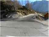 2
2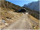 3
3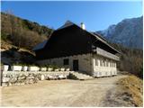 4
4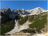 5
5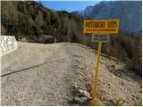 6
6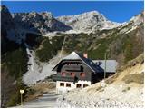 7
7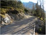 8
8 9
9 10
10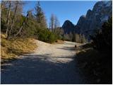 11
11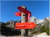 12
12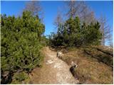 13
13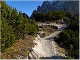 14
14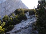 15
15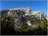 16
16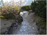 17
17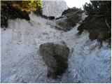 18
18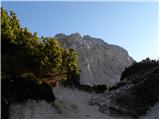 19
19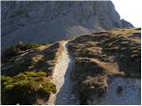 20
20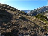 21
21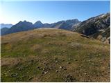 22
22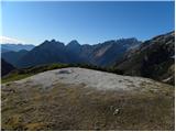 23
23 24
24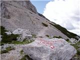 25
25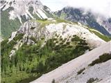 26
26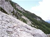 27
27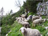 28
28 29
29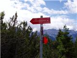 30
30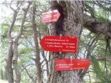 31
31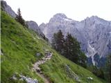 32
32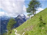 33
33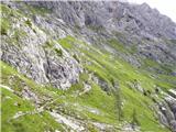 34
34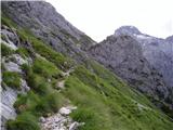 35
35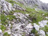 36
36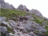 37
37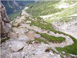 38
38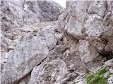 39
39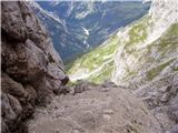 40
40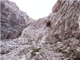 41
41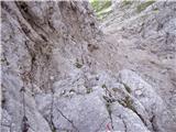 42
42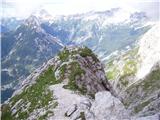 43
43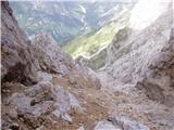 44
44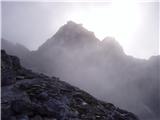 45
45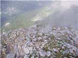 46
46 47
47 48
48 49
49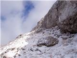 50
50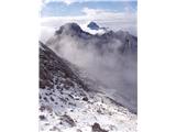 51
51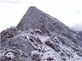 52
52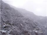 53
53 54
54
Discussion about the trip Vršič - Prisank / Prisojnik (Slovenian way)
Show older messages
|
| Gost13. 05. 2007 |
What are the conditions like to Prisank. I would go next week, but does anyone know if there's still a lot of snow up there
|
|
|
|
| Gost13. 05. 2007 |
I'm also interested if there's still a lot of snow up there? LP
|
|
|
|
| Gost15. 05. 2007 |
I was there just yesterday and I can say it was fantastic, only the wind was blowing like crazy  regarding snow, no panic, there's almost none left. But if you decide to go through the window, be careful, there's still quite a bit. Nika regarding snow, no panic, there's almost none left. But if you decide to go through the window, be careful, there's still quite a bit. Nika
|
|
|
|
| Gost13. 09. 2007 |
hi next week we're heading to Prisank, does anyone know if there's any snow up there? thanks
|
|
|
|
| mojcej'724. 07. 2010 |
Today on 4.7.2010 very early in the morning I threw my backpack, rope and poles into the car, went to Vršič and dashed up towards Prisojnik. Over Sovna glava past sheep, through scree slopes, all along the southern slope of Prisank to the part where the cables and pegs start, a bit further crossed about 130m snow patch, got tired with ascents to Zadnje okno, descended back to the saddle and slogged up to Prisojnik in the greatest sun. On the way back somewhere at the Grebenska-Slovenska trail junction the weather behind Razor worsened and a short thunderstorm happened just before my descent to Tičarjev dom. Personally, the trail seemed quite strenuous to me, I used 4 hours up and 3.5 hours down, as my knee is not very stable, besides I even collapsed long and weary against some rock where my concentration had already dropped a bit. At Tičarjev dom I was surprised by complete ignorance, as the serving staff was entirely occupied with foreigners (those who come to Vršič by cars/buses in impossible footwear from flip-flops to high heels, stuff their bellies and then drive off to pollute Trento too), for us "Slovenian" hikers they had no time. I satisfied my hunger at Koča na gozdu instead. Otherwise YES great day, if only I didn't have to go to work tomorrow.
|
|
|
|
| tonin14. 07. 2010 |
does anyone want to go to Prisank this weekend, or somewhere else but no company, let's go together
|
|
|
|
| kamnik14. 07. 2010 |
I'm heading to Prisank on Saturday
|
|
|
|
| gKavka14. 07. 2010 |
I'm also setting off on Saturday via Kopiščarjeva, looks like there will be quite a few of us, hope to start as early as possible...
|
|
|
|
| NEIC00816. 07. 2010 |
Today walked the southern route. I don't know why the signs say 4 hours?? Arrived in 2.5 hours, and I'm not among the fast ones??
Wonderful view.
|
|
|
|
| Sano18. 07. 2010 |
Hello! Is there still any snow anywhere on the southern path? Thanks for the reply.
|
|
|
|
| NEIC00819. 07. 2010 |
Nothing.. Small snow patch at the entrance to the ''wall'', but it's not on the path.
Good luck!
|
|
|
|
| Sano19. 07. 2010 |
Thanks, but unfortunately I didn't see it in time. Today I tried the Slovenska pot, but apparently missed the last turn-off for the Slovenska, so I reached the snow blocking the path. So I climbed around the rocks, later there were fixed cables. At the end of the ascent I turned back, where there was the turn-off to Zadnje okno and I didn't reach the summit.
Can someone tell me which path that was that I took? Thanks.
I'll try the Slovenska again next time.
|
|
|
|
| IgorZlodej19. 07. 2010 |
At the junction it's very clearly marked on the rocks. First the Milnarica-Razor path branches off right downwards, a few meters further left up Prisojnik and right ahead Zvoniki or towards Zadnje okno. If you had reached Škrbina you would just turn left and after a section of via ferrata reach the southern path, and ascend to the summit of Prisojnik via it. Today, when descending the southern path around 11:00, I really saw quite a few people going on the mentioned path under Zvoniki. It's also nicely marked on the direction signs on the larch on Gladkem robu.
|
|
|
|
| Sano19. 07. 2010 |
Thanks for the explanation - obviously I wasn't that far anymore though.
But I found out that exactly on that rock where the left turn up to Prisojnik is, there were 3 hikers standing at that time, so I didn't see the junction. They also went straight along that path afterwards and thought it was the Slovenska pot.
|
|
|
|
| Virenque19. 07. 2010 |
@Sano: the same happened to me. In the fog I missed the left junction for the south path. Then I went along that path as mentioned by IgorZlodej, climbed some chimney equipped with pegs and staples vertically under Prisojnik and reached directly onto the south path. Only then did I really realize that I had missed the south path and descended via it.
|
|
|
|
| Sano22. 07. 2010 |
Well, today I finally reached the summit too, this time via the Slovenska pot View magnificent!
|
|
|
|
| oiven3. 08. 2010 |
have a nice day..on Thursday I'd go to Prisojnik if weather permits,,anyone know what conditions are like on Slovenian path after recent rains??? thanks..
|
|
|
|
| jersy3. 08. 2010 |
conditions are completely summer-like, but the terrain will probably be quite wet due to today's rain and tomorrow's showers.
|
|
|
|
| Svarun253. 08. 2010 |
Yesterday I went up the ridge and down the Slovenska, no special features. 1m2 of snow below the summit that's it. If it rains it will probably be quite slippery so be careful.
|
|
|
|
| oiven3. 08. 2010 |
yeah nothing.. thanks for the info. tomorrow it will probably be clearer..
|
|
|
|
| kris21. 08. 2010 |
Tomorrow I would go up the ridge, and then down the Slovenska, I'm interested if the path is well secured with cables, if it's harder than to Triglav, because I would take my child with me? Thanks..
|
|
|
|
| IgorZlodej21. 08. 2010 |
Difficulty is a relative thing, if the child has already been to Triglav, then he shouldn't have problems on this path either, of course you have to consider that Prisank is not as secured as Triglav. Maybe do the path yourself first, then with the child!?
|
|
|
|
| kris21. 08. 2010 |
thanks for the information
|
|
|
|
| kris22. 08. 2010 |
Today I was up there without the child so next year he can go, it's really quite exposed and less secured than Triglav
|
|
|
|
| mikkeni2. 06. 2011 |
heeej, is there already some variant to go to Prisojnik, or is there still a lot of snow?!!!
|
|
|
|
| IgorZlodej3. 06. 2011 |
At least two dry variants and two still snowy in the upper part are available for the ascent to Prisojnik.
|
|
|
|
| JusAvgustin26. 06. 2011 |
You know you acted wisely because without winter gear you shouldn't tempt fate even if the ledge is 10m.
|
|
|
|
| el rocco13. 08. 2011 |
Today I conquered the summit of Prisojnik with slight difficulties. Difficulties because cramps started grabbing me just below the summit. For a few minutes I had real problems which I then effectively solved by rubbing snow on my thigh. Well anyway, what I wanted to say is that I was surprised that people dare to go up without a helmet, or even more, that they take small children with them. OK, I don't want to generalize.. everyone has their own opinion, but I think small children don't belong on Prisank. Prisank is demanding and not to be underestimated.
|
|
|
|
| furman13. 08. 2011 |
Tomorrow I'm going to Prisank. Or rather, given today's conditions, which path is safer and easier: the Slovenian or the ridge one.
|
|
|
|
| el rocco14. 08. 2011 |
Primoza, don't worry about fitness ). I have cramps problems all the time... Anyway regarding Prisojnik I didn't mean that children couldn't physically conquer it, but because it's well exposed to falling rocks, steep, and there are quite a few awkward passages and pegs. Nevertheless, as I said, everyone has their own view on what is easy and what is hard.
|
|
|
|
| Irina15. 08. 2011 |
Female curiosity. What do these numbers mean?
|
|
|
|
| pikica115. 08. 2011 |
And now others have to move your junk that has nothing to do with Prisank. I don't care much about your elevations, that's purely your personal thing where you walk and how much. Just marking some summit for pensioners says a lot about you. Bahač
|
|
|
|
| JusAvgustin15. 08. 2011 |
no, that's all about tolerance on the forum, which has become a real farce. Live and let OTHERS live too. With these thoughts I have ended my presence on the forum.
I wish you many beautiful and above all safe ascents.
Juš
|
|
|
|
| IgorZlodej15. 08. 2011 |
Juš, you surely didn't mean it seriously, those figures don't appeal to me either.
As for muscle cramps, despite all science, the best help is still proper fluid, which should not be water or alcohol.
|
|
|
|
| IgorZlodej15. 08. 2011 |
I fully agree with the above entry. First and foremost is proper psychophysical condition. Unfortunately, it is found that most do not have it, they cannot even manage one day trip, even though all our mountains are accessible in one day and allow return to the valley. GRS notes that many are completely exhausted already on the ascent and literally have to be taken down from the mountain, as they are not capable of even a step more. The entire physical activity is crucial here, as well as gradualness. As for fluids and nutrition, each individual is different and sharpens both to perfection with regular hikes or training.
As for children. I am by no means against taking them to more demanding mountains as well. Responsible parents who have their own mountaineering or climbing path behind them handle this very well. Of course, there are also those who force the child into something it doesn't enjoy at all, or protect it on demanding paths as if they were walking their pet in Tivoli.
|
|
|
|
| gosser15. 08. 2011 |
Does the view of the Hayrack Girl also open on the Slovenian path?
So there is really no need for a self-protection kit on this path?
|
|
|
|
| Bojan_A15. 08. 2011 |
No, there is no need. The view of the Hayrack Girl opens only from the lookout point at the Postman's Hut, not on the path itself.
|
|
|
|
| ruševec26. 08. 2011 |
Better than Mihelič wrote in the Julijske Alpe guidebook he couldn't have. He wrote that the southern-Slovenska path is the easiest path to Prisank, but the longest. The ridge one is harder but more beautiful and interesting. On the Slovenska path there are few fixed protections, so you have nowhere to clip in and belay. That's not necessary either. But caution is needed on the descent, as there is no lack of scree in the upper part.
|
|
|
|
| main24. 09. 2011 |
Today several hikers again missed the junction to the Slovenska or southern path. Therefore I ask the relevant PD to mark the junction at eye level or lower. Currently the mark is 2.5m above the path where no one sees it.
|
|
|
|
| IgorZlodej24. 09. 2011 |
For the tour one must prepare properly, meaning familiarize with the path description, difficulty, orientation, get a mountaineering map and learn to read it, and know how to find path junctions and continuation.
|
|
|
|
| Kozorog24. 09. 2011 |
I completely agree with Igor!!! I went up and down in fog and didn't miss anything!!!! But I know quite a few who would easily miss the toilet at home... no hard feelings!
|
|
|
|
| main25. 09. 2011 |
Why make excuses, then everyone goes to the mountains unprepared. The Slovenska pot is completely unmarked in the summit section. Shame on PD Pošta and Telekom Ljubljana.
|
|
|
|
| gti27. 09. 2011 |
The junction is poorly marked and (despite preparation) can be overlooked. This is proven by numerous visitors who go to the end and reach the Jubilee path. Given many overmarked paths, a more visible sign could be added at this controversial junction, like e.g. on Gladki rob?!
|
|
|
|
| Meto1. 10. 2011 |
I don't know what poor markings you're talking about, but to me the path seemed more than decently marked (especially in the upper part it's practically impossible to miss anything because all switchbacks are marked), and I visited Prisank for the first time. And I (well, we) were quite fussy about markings, so we even managed to miss the cables, followed by a few meters of free climbing... as for rocks, helmet is more than recommended and especially caution on descent.
|
|
|
|
| dedo2429. 11. 2011 |
The southern path to Prisank is mostly dry except for the gully, where there were no major issues due to snow. You can view the pictures at this link: /www.pdmaticams-drustvo.si/
|
|
|
|
| urbancek30. 11. 2011 |
In my opinion, these easier paths for someone climbing Prisojnik for the first time are poorly marked at the start and summit, especially when someone who has no clue where the Grebenska or Slovenska path runs descends from the top, how on earth will they find one or the other? Might they go unwittingly straight to the last window? Mark these paths clearly at the top and bottom with clear signposts! This is my personal observation on this mountain.
Best!
|
|
|
|
| urbancek30. 11. 2011 |
@main: that's right and that's what I wanted to draw attention to with the above post...
Sloppiness that shouldn't happen on such a visited and popular mountain!
|
|
|
|
| mukica1. 12. 2011 |
I agree with urbancko, very poorly marked. I'm already one of those who missed it this year, even though it wasn't my first time up there, company and chat, carelessness and we continued. Since I have quite some experience it worked out well, for many it's unpleasant, annoying... the companion waited because she didn't dare go on....
|
|
|
|
| ljubitelj gora1. 12. 2011 |
I missed the junction towards Razor back then, I should have turned slightly uphill, but I continued straight ahead, but that was at the beginning when I started hiking in the mountains, now I navigate well orientationally.
|
|
|
|
| urbancek1. 12. 2011 |
This has nothing to do with navigating well orientationally.. It's about the path marking, which some people might hike only once in their lifetime, and various foreigners and others from afar, those climbing for the first time etc..
Regardless of personal mountaineering experience, some paths should be exemplarily marked, since we've already decided so... Not to mention those that are more frequented, among which Prisojnik undoubtedly belongs, especially the mentioned path on the southern side...
Best regards!
|
|
|
|
| urbancek1. 12. 2011 |
@primoza: I think you are not exactly the target audience of this debate... It's mainly about people who have no idea about the paths on Prisojnik... and for them it was poorly marked on my last visit, no matter how you turn it...
|
|
|
|
| jax3. 12. 2011 |
Regarding Prisojnik and the marking of the path to it, I'd say: I was up there this year and I think it's not that bad. Of course it could always be better. For example: when the path from Vršič branches off down to Kopiščarjeva, the junction only says Prednje okno. Now, which path is it, Kopiščarjeva or the ridge one? Similarly up near the summit where the ridge and southern paths meet. At the branch for the southern path it only says Vršič. Which path to Vršič is that - God knows. A bit of intuition and a map resolve all doubts, and in general orientation is not problematic. Not ideal, though. As for the marking of the southern path itself - I really noticed no issues (though I only did it on descent).
Regarding Jalovec to Jezerca - a few years ago I went from Špička towards Jalovec in really thick fog. When nothing was clear anymore, I followed the classic rule for marked paths in fog - if I don't see the next mark from the current one, I'll turn back. And I reached the summit... So, by my experience, it's not that bad.
|
|
|
|
| JusAvgustin3. 12. 2011 |
If you always have a map in your backpack and know how to use it, you don't need markings at all
but the map is an integral part of the equipment! The problem is that people want everything marked...
|
|
|
|
| urbancek3. 12. 2011 |
Yes jax, I agree, but I'm not the only one who pointed this out, though some have forgotten about it...
@Jus: Of course not everything needs to be marked, but if we've decided to mark the paths, let it be exemplary, especially in such popular mountains where masses of people flock on nice summer days.
Regarding tour preparation, everything you wrote holds true... Map, web, route description, equipment check and more... All that is quite correct. You just forgot to ask how many people actually do that? I think for this mountain in nice summer months the share is relatively small (various guys in sneakers, and families not very mountaineering literate -> it seems to me there are quite a lot of such occasional summit visits then) And my remarks were aimed precisely at that target group...
Best regards!
|
|
|
|
| joža x3. 12. 2011 |
Signposts, warnings, paved paths... - we already have that in the valley. We don't want less of it in the hills, if we follow the principle of gradualness in the hills, the urbanite won't have problems nor anyone else. Markirists won't deal with pointless tourists who don't know what to do with their time and money, but go to the mountains anyway.
|
|
|
|
| urbancek3. 12. 2011 |
joža x: if you read well, you'd see that I have no problems with it, I just wrote my observations for others...
Anyway, I'm for closing this debate, the purpose was achieved, which is exchanging opinions about this path...
|
|
|
|
| Becar7. 07. 2012 |
15 years ago, three of us intended to go along the southern route, somewhere on the southern side of Prisojnik we missed the left turn. We continued towards Razor but then found another path left upwards to the Prisojnik ridge, descended across to the northern side and crossed somewhat below the ridge to the summit. The path from the ridge onwards seemed to me at that time quite exposed, crumbly and not very secured, and to this day I don't know which path it was  Does anyone here know? We didn't go through or past any of the windows. Thanks. Best regards Does anyone here know? We didn't go through or past any of the windows. Thanks. Best regards
|
|
|
|
| Becar7. 07. 2012 |
...one more thing. During the crossing below the ridge, I remember a memorial plaque to some Kranjska Gora priest, if I'm not mistaken.
|
|
|
|
| dprapr7. 07. 2012 |
I assume that before Zadnji Prisojnik you came to the Jubilee Trail, which leads right ahead to the last window. But you went left towards Prisojnik! That path is indeed less secured (at least it was when I was there last), and it leads along interesting ledges above the cliffs.
Best regards
|
|
|
|
| Becar7. 07. 2012 |
Is this section then also part of the Jubilee Trail, or one of the described routes on hribi.net or completely something third?
|
|
|
|
| Becar8. 07. 2012 |
Thank you very much for the reply. Lp
|
|
|
|
| el rocco11. 07. 2012 |
Exactly as dprapr wrote. On Saturday 7.7.2012, my wife and I went up the Slovenian path because last year's experience taught me that there might still be some snow at the end of the Jubilee path. From what I could see on Saturday from the viewpoint below the summit, except for a small patch somewhere in the middle the path is clear, although I didn't see anyone going on it. I must also praise the PD who painted a large white arrow on the rock marking the branch to the Slovenian path, so now you really can't miss it. Otherwise excellent except for puffing at the top.
|
|
|
|
| zvone128. 07. 2012 |
Would anyone go on 29.7. from Vršič along Slovenska pot to Prisank? I'm from LJ.
|
|
|
|
| zvone129. 07. 2012 |
up the north side of Prisank, down the south. pleasant tour
|
|
|
|
| Ajda_Zitnik6. 08. 2012 |
I hiked the trail yesterday. It does not seem poorly marked to me, but you need to very carefully watch where the lines point all the way (there were relatively few Knafelč markings in my perception). Above all, I would emphasize once again that caution is needed in the summit section due to gravel on the path.
|
|
|
|
| nominator17. 08. 2012 |
It could be marked as very demanding. It's not for everyone. My rating 3-4. lp
|
|
|
|
| kramarvp1. 09. 2012 |
I'm planning a path from Vršič to Pogačnikov dom, and a little around. Any suggestions?
|
|
|
|
| Benč1. 09. 2012 |
I was a few days ago circling these paths that you mention.
There is also GPS track on the description.
Shortcut to album
|
|
|
|
| jetamp23. 09. 2012 |
@kramarvp, if you have the chance start from Zadnjica to Luknja then to Bovški Gamsovec and to Pogačnikov dom. Overnight there and next day to Razor and Planja then towards Vršič! From Sedlo Planja good 4 hours walk. Good luck!
|
|
|
|
| sebasu18. 10. 2012 |
On Saturday 20.10.2012 I plan to go to Prisojnik via the Slovenska pot.
I'm interested in how much snow there is and if crampons are needed.
Thanks for the reply.
|
|
|
|
| SunBurned20. 10. 2012 |
I plan to go the same path tomorrow, too bad no one has responded with any information.
But if the northern one to Mala Mojstrovka has no snow, I think the southern one to Prisank doesn't either.
|
|
|
|
| natfal22. 10. 2012 |
Anyone have latest info on Prisojnik, as 3 of us going up tomorrow. Thanks and lp
|
|
|
|
| hrib0vc17. 07. 2013 |
I'm interested if the southern path to Prisojnik is already snow-free, or if it's better to wait a bit if we're going without crampons.
Thank you for the reply.
|
|
|
|
| pemi8. 07. 2014 |
can someone hint how much secured parts there actually are here, I mean wires ...pegs.. :-)
thanks
|
|
|
|
| Macesna8. 07. 2014 |
There are not many wires and pegs, but it's a rather tricky path because it's quite loose (crumbly) and you have to rely on your firm and reliable step. This applies especially to the summit section, where there are inclined slabs covered with scree. You must not be tired! In the summit section, you also need to choose the path well (in fog it can be an exceptional problem), as the trail gets lost in places. The same (or even more) applies to the descent in the summit section.
Of course, it's not some bogeyman, there are harder paths, but it's not entirely simple either - precisely because there are almost no wires and pegs. Definitely not for everyone.
|
|
|
|
| pemi8. 07. 2014 |
Thanks, I agree it's easier if there's a chain and you can hold on, the problem is precisely those exposed sections :-D thanks
|
|
|
|
| kanin44425. 08. 2014 |
I'm interested in how much the rocks are crumbling
|
|
|
|
| Keko25. 08. 2014 |
If you look at the previous posts a bit, you'll find the answer.
|
|
|
|
| BlackDiamond10. 05. 2015 |
How is the exposure on this path? Is the path suitable for a beginner in the world of steel cables and pegs?
|
|
|
|
| Branee10. 05. 2015 |
The ridge one is much nicer also less "loaded" with rocks. In my opinion by far the least interesting path to Prisojnik. Exposure is not great it's lower class of these paths here, comparable to the path through Skar. Rob from Storžič.
|
|
|
|
| heinz11. 05. 2015 |
BlackDiamond you're asking - Is the trail suitable for a beginner in the world of via ferrata cables and pegs?
I think it's not for any kind of beginner. For tasting via ferrata, it's better to choose a shorter and only partially demanding tour. Otherwise, as predecessors say, there aren't many here, or rather just a sample.
|
|
|
|
| ms_primoz11. 05. 2015 |
The trail is perfectly suitable for a beginner. Of course, they must have at least some fitness. Example, sitting on the couch for 20 years and then going to Prisojnik - I advise against it. Regarding "danger", it is fully recommended, why not?
Just slowly and carefully.
|
|
|
|
| ms_primoz11. 05. 2015 |
yes, it's true, there are almost no pegs and cables.
|
|
|
|
| jax11. 05. 2015 |
To be completely honest, I don't see much sense in ascending and descending Prisojnik via the southern route. The ridge one is only a hair more difficult (really, the difference is much smaller than many write) and much more scenic. The southern is then quite nice for descent. This combination already makes a decent tour.
How about exposure on this trail? Yes, the ridge has quite a few exposed sections. But again - nothing particularly demanding. Go to Gradiška tour first and if that doesn't trouble you, this combination won't either.
|
|
|
|
| darinka412. 05. 2015 |
If you want more adrenaline, I recommend Hanzova, northern, very nice real pleasure, there you need a via ferrata set and helmet. Southern is more suitable for descent. Ridge one is nice, I like to go on it the most.
|
|
|
|
| Branee12. 05. 2015 |
Don't send beginners to Hanzova... There you need more than just a helmet and set anyway.
|
|
|
|
| ms_primoz12. 05. 2015 |
darinka4 - even more adrenaline without helmet and self-belay. and in flip-flops. Especially today or tomorrow would be fine. But not Friday, because apparently rain/snow
|
|
|
|
| darinka412. 05. 2015 |
Hanz's route is suitable in late summer when there is no more snow, that's when we went along it, nothing special, I don't know why it would be difficult, it seemed completely normal to me, and I don't have much experience.
|
|
|
|
| darinka412. 05. 2015 |
Hanz's route is suitable in late summer when there is no more snow, that's when we went along it, nothing special, I don't know why it would be difficult, it seemed completely normal to me, and I don't have much experience.
|
|
|
|
| ms_primoz12. 05. 2015 |
Which path is 'difficult' for you then?
|
|
|
|
| tinky12. 05. 2015 |
Kopiščarjeva through the window is not really for a 'walk'.
|
|
|
|
| Branee12. 05. 2015 |
Darinka, unfortunately it's clear from the comments that you're inexperienced. It seems that what you hike, someone leads you. Misleading a beginner to Hanz's with just a helmet and safety gear is terribly wrong.
|
|
|
|
| jax12. 05. 2015 |
The question is, what do you understand by beginners. Clearly, it's a demanding high mountain ascent that is certainly not suitable for the first tour of someone who previously only walked from the sofa to the fridge. But I think it's a perfectly fine choice for someone who wants to first encounter somewhat more demanding paths.
Or, say, if someone went to Triglav (many inexperienced rush up there, as we all know), and liked it and wanted to try another high mountain ascent of similar format, then Prisojnik is a solid choice.
|
|
|
|
| ljubitelj gora12. 05. 2015 |
The ridge path could also just be a demanding marked path, because then everyone thinks that Kopiščarjeva/Hanzova is equally demanding as the ridge one, because of the rating.
|
|
|
|
| darinka413. 05. 2015 |
For the first time I've heard from someone that I'm inexperienced. I really laughed. I've been going to the mountains for 40 years. Often I go alone because I like it, or take someone with me. I know Prisojnik well, as I've been up there many times and it's my favorite mountain. 
|
|
|
|
| Branee13. 05. 2015 |
I can write this once again, it won't be the first time.. Advising a beginner who fearfully asks for information about the southern route to Prisojnik that he shouldn't go with a helmet and safety gear on Hanz's route says a lot about this "supposed" experience
|
|
|
|
| Maticc5. 07. 2015 |
I'd like to warn that the cable on the Slovenska pot is torn on the exposed, precipitous section.
My friend and I assessed that crossing the smooth rock without proper holds would pose too great a risk. So we turned back.
For the knowledge of others seeking a safe step.
Good luck.
|
|
|
|
| peterveter3. 08. 2015 |
Maybe someone knows how it is now with this cable? Is the path passable?
|
|
|
|
| Gost3. 08. 2015 |
The path is passable.
At places where there is no cable, there is a rope for assistance. Don't go on this path without a helmet, a via ferrata set is also not superfluous, and if you're going there for the first time, it's good if someone experienced with the path and conditions goes with you. Check the forum a bit.... you'll find current conditions, and there are photos too. Good luck
|
|
|
|
| Vanilla13. 06. 2016 |
Does anyone know how it is now with the cable and snow conditions on the southern path? Thanks!
|
|
|
|
| sid5. 08. 2016 |
The path towards Škrbina and further along Jubilejni to Vrh is beautiful. The views you don't see from other directions are priceless. Despite the excellently marked section (slovenska-2okno), I managed to miss it...
When I descended via the Slovenska path, I really couldn't believe I overlooked probably 5 painted rocks in one place...
|
|
|
|
| ribnik6. 08. 2016 |
What are the conditions (reply to Vanille's question) for tomorrow's ascent?
Thanks!
|
|
|
|
| vodenjačica5. 06. 2017 |
Yesterday 4.6.2017 we descended from Prisojnik via the Slovenian trail and it still has snow and ice (locally several meters high). On descent we had to cross very steep snowfields (about 100m long) three times. Since snowfields cannot be bypassed, ice axe and crampons mandatory and caution for sure.
We ascended the ridge trail to Prisojnik and there is no snow or ice on it, but slippery and wet locally, proceed carefully.
|
|
|
|
| navdušena9. 07. 2017 |
There is no snow on the Slovenska pot. The path is "moderately demanding", I'd say, but caution is needed...Self-belay kit for the Slovenska pot? Only very, very rarely can you use it, I think there are 3 wire ropes on the entire path.

|
|
|
|
| cajer18. 09. 2018 |
The plan for the first ascent to Prisojnik was up and down the Slovenska pot. Things got 'complicated' after we missed the fork on the southern side. We continued on the path leading around the 'whole' mountain, also on the northern side (II. okno, Kajzljeva skrbina if I'm not mistaken). The path there is incomparably harder than the Slovenska.
Be careful at the fork on the southern slope - it's not marked with a sign, but there are arrows drawn on the ground that clearly show the right direction.
On the way down (this time on Slovenska) we met a group of German-speaking hikers who had also missed that same fork.
|
|
|
|
| Anja0075. 06. 2019 |
I'm wondering how exposed/aerial this path is? I've wanted to go for some time now, of course, in summer time, but I'm not entirely sure, mainly because of the exposure.. My knees get a bit weak looking at the abyss For comparison, so far I've been on more demanding paths on Ojstrica (via Mala Ojstrica), on Storžič (Škarjev rob), Mangart (Italian), and something else could be found. Thanks for the advice
|
|
|
|
| jax5. 06. 2019 |
It is not exposed. The biggest problem is the steep scree, which requires some caution. There is no particular airiness or difficulty.
|
|
|
|
| Anja0076. 06. 2019 |
Great, thanks for the info. Can't wait
|
|
|
|
| Dario GK13. 08. 2019 |
We were there yesterday....gorgeous
|
|
|
|
| Pušjakec6. 08. 2020 |
Hello,
I'm interested if anyone has been to Prisojnik recently and how it is?
Thanks and best regards
|
|
|
|
| trdi777. 08. 2020 |
I only read that Kopiščarjeva pot is closed
|
|
|
|
| glorija8. 08. 2020 |
Hello,
I was on the Slovenian path yesterday, Kopiščarjeva and Jubilejna are closed (that's what I read recently)...
Slovenian very nicely marked, kudos to PD...Mountain greetings, safe steps to all..
|
|
|
|
| kajla14. 09. 2020 |
Since I always descended from Prisojnik along the ridge, this time I chose the Slovenska pot. The name sounds pleasant, but not for the path. Slovenski šoder would suit it better.
I also missed that junction up there, when I realized my mistake and turned back, I met two Austrians who had missed it too. A slightly better marking of the junction would be very welcome. When looking underfoot, it's no problem to miss the cairns.
Otherwise, I enjoyed the beautiful views on the path and alpine flowers in the lower section.
|
|
|
|
| plani narko13. 06. 2023 09:07:15 |
Hello, is there snow around 20.-30.6. on Prisojnik?
|
|
|
|
| koblihson6. 05. 2024 16:39:58 |
Is a helmet required on this trail?
|
|
|
|
| nejcf6. 05. 2024 19:09:30 |
Just take it, there's a lot of scree. Last time I was on this trail, some guy with a dog was happily kicking stones onto everyone below him.
|
|
|
|
| Tina A. 8012. 06. 2026 06:34:42 |
Is the Slovenian path completely dry?
|
|
|
To post a comment you must log in:
If you do not yet have a username, you must first
register.