Vrtovin - Kucelj (on Čaven)
Starting point: Vrtovin (350 m)
| Latitude/Longitude: | 45,90952°N 13,81815°E |
| |
Walking time: 2 h 20 min
Difficulty: easy marked way
Elevation gain: 887 m
Elevation difference along the route: 877 m
Map: Goriška 1:50.000
Recommended equipment (summer):
Recommended equipment (winter): ice axe, crampons
Views: 27.496
 | 1 person like this post |
Access to starting point:
a) From the Razdrto - Nova Gorica expressway, take the Ajdovščina exit, then at the intersection turn left towards Nova Gorica. Continue on the regional road to the village of Vrtovin, then in the middle of the village turn right towards Čavna. Follow the road that climbs through the village at intersections in the direction of sv. Pavel, Kucelj and Čaven. Drive to the hamlet of Lozarji, where we park at the new, purpose-built asphalted parking lot for hikers (next to the parking lot there is an information board, wooden benches with a table and a drinking fountain).
b) From the Nova Gorica - Razdrto motorway, take the Selo exit, then at the intersection turn right onto the old regional road towards Ajdovščina. Drive to the village of Vrtovin, then in the middle of the village turn left towards Čavna. Follow the road that climbs through the village at intersections in the direction of sv. Pavel, Kucelj and Čaven. Drive to the hamlet of Lozarji, where we park at the new, purpose-built asphalted parking lot for hikers (next to the parking lot there is an information board, wooden benches with a table and a drinking fountain).
Route description:
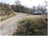
From the new arranged parking lot in the hamlet of Lozarji, we first head back about 150 meters along the road, then turn left uphill towards the former parking lot at the end of the village, where mountain trail signs are located.
From here we continue on the left road in the direction of Kucelj and sv. Pavel. After a few minutes of walking, the road brings us to a trail junction, where the marked mountain trail to Kucelj and Čaven branches off to the right uphill (straight ahead on the road sv. Pavel). We continue the ascent on the marked, partly stony cart track that climbs through occasionally sparse forest. A little higher we reach a marked junction, where we continue slightly left in the direction of Kucelj (right Mala gora and Čaven).
The well-marked cart track, which we follow in the direction of Kucelj, brings us a little higher to a forest road, which we simply cross. The path ahead climbs gently through sparse forest, but only to the point where the path from Sveti Pavel joins from the left.
The path ahead begins to climb steeply through the forest, through which we climb for quite some time. Higher up we cross the Srednječavenska path, above which the forest slowly begins to thin. A little higher the path comes quite close to the old road connection between the Vipava valley and the Trnovski gozd plateau.
Here the path to Visoki rob and Selovec branches off to the left, but we continue straight on the marked mountain trail, which slowly turns slightly to the right. Further on the forest finally ends, and the path, from which views open towards Veliki rob, the Vipava valley and Trstelj, brings us to the last junction on our route. We continue right again and in a few minutes ascend over the scenic grassy slope to the summit of Kucelj, from which a view towards Nanos and Golaki also opens.

The trip can be extended to the following destinations: Veliki Rob
Photos:
 1
1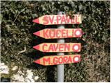 2
2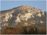 3
3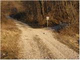 4
4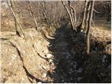 5
5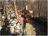 6
6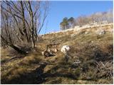 7
7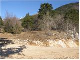 8
8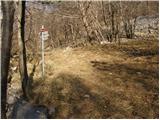 9
9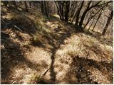 10
10 11
11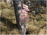 12
12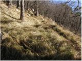 13
13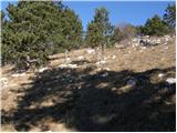 14
14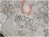 15
15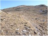 16
16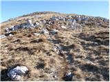 17
17 18
18
Discussion about the trip Vrtovin - Kucelj (on Čaven)
|
| marei13. 03. 2008 |
We started the path from Vrtovin. In terms of difficulty, this is no longer Kucelj, but a mountain. Nice trip and I recommend it.
|
|
|
|
| furioso24. 08. 2008 |
Yesterday I was at Kucelj from Vrtovina. The path is quite overgrown, otherwise it's a quite strenuous steep ascent.
|
|
|
|
| pier18. 01. 2010 |
I did the path on Saturday 16.01. Snow starts somewhere at 1000m, the upper part before accessing the top is partly icy (nothing sinks in) so at least an ice axe, if not crampons, is mandatory. We didn't stop at the top because the wind was blowing so hard it felt like we were flying back to the valley. We continued through the forest to the Anton Bavcer hut at Čavn, where the friendly caretakers served us lunch. We descended towards Mala Gora and continued to the Lovska koča (where the snow ends) and further to Vrtovin.
|
|
|
|
| urskabacar15. 08. 2016 |
Yesterday we climbed to Kucelj via the described path. The path is steep, quite overgrown and often requires caution (especially on descent) and of course proper footwear. The view from the top is wonderful and I definitely recommend the visit, but I think it is possible to reach the top more easily via one of the other paths.
|
|
|
|
| BT8815. 08. 2016 |
Yes, this year it is really more overgrown, last year at this time the path was fully mown.
|
|
|
|
| akvarij9. 10. 2016 |
Today we went on this trail, it was very nicely cleared and also marked, except at the beginning when you go along that cart track (or, it looks more like a torrent gully to me).
Since the trail is really steep, poles are useful for descent, and of course appropriate footwear.
|
|
|
|
| BT8811. 10. 2016 |
To avoid the gully I recommend another 15 min from picture no. 4 along the road and then right (also sign) where we reach a nice grassy path, which I'd recommend also for descent. The mentioned path is again nicely mowed and cleared.
lp
|
|
|
|
| akvarij15. 10. 2016 |
BT88, thanks. I thought so, that when I went to St. Paul a while ago, I also saw signs for Kucelj further on!
|
|
|
|
| smeh131. 10. 2016 |
On the path to Kucelj on Čavnu found Peugeot keys
|
|
|
|
| anazala7. 07. 2019 |
If you have time, recommend it. From quarry bit uphill. First to Čaven to hut, then Kucelj, then down from Kucelj via Srednje Čavenske poti. At path marked -Tuneli. Turn left. Then through middle of Čavna hill back to cliff-climbing wall. Notice paths from hill. Continue to cliff, rope there, more attention, not dangerous. Careful, don't overtake hikers you'll meet. Overtook climber, waited descent then continued. Then small scree straight to quarry. Super path. ~6h with stops. Some minor.
|
|
|
To post a comment you must log in:
If you do not yet have a username, you must first
register.