Zadnja Trenta (Flori) - Jalovec (via Zavetišče pod Špičkom)
Starting point: Zadnja Trenta (Flori) (900 m)
| Latitude/Longitude: | 46,40430°N 13,70980°E |
| |
Route name: via Zavetišče pod Špičkom
Walking time: 5 h 45 min
Difficulty: very difficult marked way
Elevation gain: 1745 m
Elevation difference along the route: 1755 m
Map: TNP 1:50.000
Recommended equipment (summer): helmet, self belay set
Recommended equipment (winter): helmet, self belay set, ice axe, crampons
Views: 67.180
 | 8 people like this post |
Access to starting point:
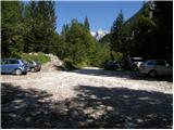
From Kranjska Gora we drive over the Vršič pass towards Bovec or vice versa, but only as far as the 49th hairpin bend of the Russian Road (near the village of Trenta). Here we turn onto the side road in the direction of the source of the Soča River. The road after a short ascent quickly brings us to the parking lot in front of the hut at the source of the Soča, we however continue left across the bridge and follow the road further to the parking lot at the end of the road (at the parking lot we notice mountain signs for Bavški Grintavec, the Suhi potok waterfalls and Jalovec).
Route description:
From the parking lot we turn right onto the footpath towards Jalovec and Zavetišče pod Špičkom (the left path leads to Bavški Grintavec). The path from which a nice view of the already mentioned Bavški Grintavec opens up at the beginning quickly passes into a dense forest, where it begins to climb steeply. The steep path, which almost the entire time runs through the forest, takes us after about an hour and a half of walking to a junction, where we continue on the left path in the direction of Zavetišče pod Špičkom (to the right Vršič, Jalovec, Mali kot and Jalovška škrbina, both paths are marked). The path ahead flattens for some time, then begins to climb steeply again, this time through occasionally increasingly sparse forest. Higher up the forest becomes even sparser and beautiful views of the surrounding peaks open up from the path. Just a little further we come to a less noticeable junction, where a marked but little-used path to Bavški Grintavec branches off to the left (the path over Konj).
We continue straight towards Zavetišče pod Špičkom on the path that enters the belt of dwarf pines. Further we climb for some time through the dwarf pines, then we join the path from the Vršič pass.
We continue straight towards Zavetišče pod Špičkom on the path that enters the world of pastures. The path, from which beautiful views of the peaks above Zgornje Posočje open up, takes us higher to a smaller junction, where a path to Jalovec branches off to the right (the path that bypasses Zavetišče pod Špičkom). We continue straight and along the path where we notice some interesting inscriptions (verses) we arrive at Zavetišče pod Špičkom in a few minutes.
From the shelter we return a little back and then turn onto the path towards Jalovec, where the path quickly takes us to the climbing part of the trail.
The path ahead climbs first on a relatively well-secured rock rib, then climbs steeply on the wall of the lesser-known Veliki Ozebnik (2480 m). The steepness then gradually eases and the path turns slightly to the right, where it crosses steep slopes under Veliki Ozebnik that are dangerous for slipping. The path in this section is less secured and very exposed to falling rocks (helmet is mandatory!). The path ahead crosses another short exposed gully and then brings us to a softer world of grass. The path ahead slightly descends and brings us to the high-mountain plain named Jezerce. A short climb follows and from the right the path from Jalovška škrbina joins us.
The path then climbs steeply again and with some minor protections along a sometimes quite exposed path brings us to the main ridge of Jalovec. Further we climb along a narrow and occasionally very exposed ridge on the path that higher up brings us to the place where the path from Kotovo sedlo joins us from the left. We continue straight and the scenic ridge path quickly takes us to the summit of Jalovec.
Starting point - Planina Trenta 1:30, Planina Trenta - turnoff for Sedlo planja 0:50, turnoff for Sedlo Planja - junction below Špičkom 0:20, junction below Špičkom - Zavetišče pod Špičkom 0:50, Zavetišče pod Špičkom - Jezerca 1:25, Jezerca - Junction on the ridge of Jalovec 0:45, junction on the ridge of Jalovec - Jalovec 0:05.

Along the route: Planina Trenta (1398m), Odcep proti Sedlu Planja (1681m), Razpotje pod Špičkom (1769m),
Zavetišče pod Špičkom (2064m), Jezerca (2390m), Razpotje na grebenu Jalovca (2613m)
Photos:
 1
1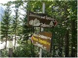 2
2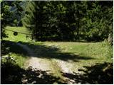 3
3 4
4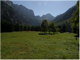 5
5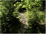 6
6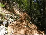 7
7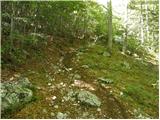 8
8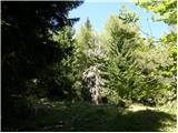 9
9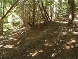 10
10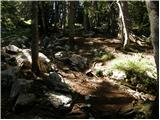 11
11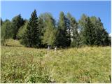 12
12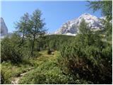 13
13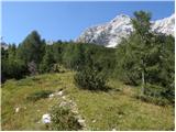 14
14 15
15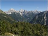 16
16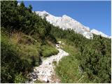 17
17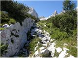 18
18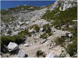 19
19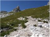 20
20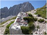 21
21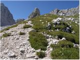 22
22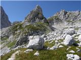 23
23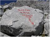 24
24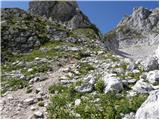 25
25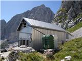 26
26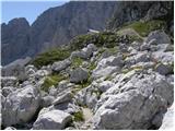 27
27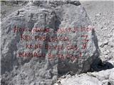 28
28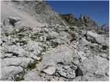 29
29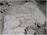 30
30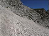 31
31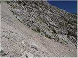 32
32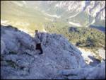 33
33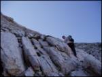 34
34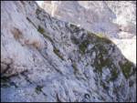 35
35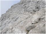 36
36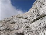 37
37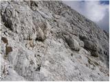 38
38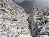 39
39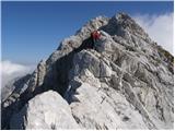 40
40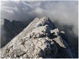 41
41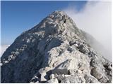 42
42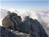 43
43 44
44 45
45 46
46
Discussion about the trip Zadnja Trenta (Flori) - Jalovec (via Zavetišče pod Špičkom)
|
| NEIC00828. 08. 2009 |
Is this the easiest approach to Jalovec?
|
|
|
|
| jersy28. 08. 2009 |
Yes, that should hold. If cables and pegs don't bother you, go ahead and try.
P.S: If you start from Trenta, you can also try a circular route, up via Jalovška škrbina (exposed but well secured) and descent to Špička
Have a nice trip!
|
|
|
|
| aljoša129. 08. 2009 |
From where do you recommend more to the shelter under Špička, Vršič or Flori?
|
|
|
|
| jersy29. 08. 2009 |
My personal opinion is that it's better from Flori, at least from Vršič on descent you lose quite a bit of altitude. Lp
|
|
|
|
| Matjaz_6529. 08. 2009 |
Polar measured for me from Vršič to the turn-off for Trenta 240 meters of elevation ... from Flori it's 900 according to the map 
also on descent it was easier for me due to knees to reach Vršič ... than to descend to Trenta ... so I'd probably choose the starting point at Vršič again 
|
|
|
|
| maiden30. 09. 2009 |
I'm curious about the difficulty if you compare the ascent to Jalovec and Bavški Grintavec (direct route)?
Yesterday I was on Bavški Grintavec and the section considered difficult justifies its rating =)
So I'm interested in the route to Jalovec (Flori-Zadnja Trenta - Jalovec).
|
|
|
|
| triglavski30. 09. 2009 |
The description is above, what else would you like to know. If you managed B.G. there shouldn't be problems on Jalovec, it's a secured route, the protections are where they are, the rest you just have to get through somehow. Otherwise, difficulty is very subjective, for some it can be extremely hard, for others nothing special. There's no universal rating. If you can't go further, you can always turn around and go back.
|
|
|
|
| maiden30. 09. 2009 |
OK ok...
Is the route to Jalovec via Jalovška škrbina by any chance easier? somehow I got that impression...
|
|
|
|
| triglavski1. 10. 2009 |
For me, via Jalovška škrbina or Mali kot is mainly shorter, the Goličica wall again depending on the person, down I definitely prefer via Veliki Ozebnik to Špička rather than via Goličica.
|
|
|
|
| maiden1. 10. 2009 |
OK.
What do you think about using a via ferrata set on Jalovec? I know it can be used, but you'll probably have a lot of work with clipping over, because on a "zajla" that's 3 meters long there can be two to three pegs... am I right somehow?
|
|
|
|
| turbo1. 10. 2009 |
Maiden, if you're going to Jalovec via Jalovška škrbina or Mali kot, the self-belay kit won't help much. The climbing section to Jezerc is mostly secured only with pitons, there are hardly any wire ropes to clip into. It's not much better further to the top of Jalovec either.
|
|
|
|
| fpetel11. 10. 2009 |
Personally, the route up via Goličica and Jalovška škrbina was easier for me than the descent towards Kotovo sedlo. There are plenty of pitons. There are some wire ropes on Jalovška škrbina. There are some on the summit too - but definitely the vertical sections over Goličica are mostly secured only with pitons.
|
|
|
|
| maiden2. 10. 2009 |
@triglavski
tell me why you prefer going back via Veliki Ozebnik? Because you don't want to go down the same way or because it should be an easier descent?
|
|
|
|
| triglavski2. 10. 2009 |
Because it's easier and I usually don't feel like hanging on those pitons downhill, plus I hop to Špička on the way, we always have something to say to each other. For the ascent it's pleasant but unfortunately a bit too short.
|
|
|
|
| maiden3. 10. 2009 |
Well thanks for the answers....
this is again relative, what is short and what is not
|
|
|
|
| triglavski3. 10. 2009 |
I was thinking of the Goličice wall of course, you just warm up and it's all over.
|
|
|
|
| gora25. 08. 2010 |
Is this path to Jalovec e.g. more demanding than Kremžarjeva to Jez. Kočno?
What is this difficulty? Exposure? Insufficiently secured path? Effort?
Thanks!
|
|
|
|
| NEIC00826. 08. 2010 |
Maybe, maybe not??
|
|
|
|
| jozo22. 08. 2011 |
This nice and quite well secured path we hiked with my wife yesterday. Securing is quite sufficient, we returned via Jalovška škrbina back to Trenta.
|
|
|
|
| ibro20. 08. 2012 |
Does anyone have the phone number for the shelter under Špičko?
LP
Ibro
|
|
|
|
| _sandra_21. 08. 2012 |
Society: Jesenice Mountaineering Association
Caretaker: Nada Šavs, Marija Meglič
Phone: +386 (0)4 586 60 70
GSM: +386 (0)41 543 039
E-mail: plan.drustvo@siol.net
Web: http://www.pdjesenice-drustvo.si/index.p ...
Address: Trenta 84
5232 Soča
@ibro: you can get all the data on the PZS website. lp
|
|
|
|
| Zgembo12. 07. 2014 |
I walked this path today, you can reach the hut under Špičko without problems, but I didn't make it to Jalovec, too much snow at the crossing to the main Jalovec ridge.
|
|
|
|
| emze23. 08. 2015 |
Not satisfied with the trail. I understand that the trail is demanding and that Jalovec is a demanding mountain, but at the same time the path from the Shelter under Špička to the summit of Jalovec is also part of the Slovenian Mountain Trail; Jalovec is a synonym for the king of mountains and PZS has it in its coat of arms. Given that, the trail around Veliki Ozebnik is downright catastrophic. Markings are mostly faded, the trail is unmaintained, and safety gear is extremely sparse except for a few cables. It is very easy to miss the trail even during the day; in bad weather (or even just like that) every mistake is fatal. And as is characteristic for Jalovec, if you are shorter than 165 cm, you have serious problems with reaches.
|
|
|
|
| darinka411. 10. 2015 |
Now the markings have been renewed, and there shouldn't be any problems, at least I didn't have any, even though visibility wasn't great due to the weather. In the gully, however, you have to be more careful, especially when descending, because of the scree, but it goes.
|
|
|
|
| AndroS11. 08. 2017 |
This year I visited Jalovec via this route. I'm not a mountaineer and this year I went on more difficult paths for the first time. I must say the path is exemplary secured and also well marked. But Jalovec is no "walk"
|
|
|
|
| navdušena19. 08. 2018 |
For the ascent to Jalovec via the path from Špička I took a via ferrata set, which I quickly stowed away. Actually, it doesn't help you with it. Where there are fixed cables, it's really not necessary to clip in, where there aren't any... The path requires a cool head and a sure step.
|
|
|
|
| trdi30. 08. 2018 |
"...Steep path that runs through the forest almost the entire time brings us after about an hour and a half of walking to an unmarked junction, where we continue on the left path..."
The description needs to be corrected here, because there are two signposts at this spot. The left one directs towards the shelter, it says 3 hours, and towards Škrbina za Gradom, it says 4 hours. The right one directs towards Jalovec, it says 4 hours, and Mali Kot, it says 2 hours.
|
|
|
|
| Tadej31. 08. 2018 |
Thanks for the info. I have updated it.
|
|
|
|
| teodor.marjanovic8. 07. 2019 |
2.7.2019: Ascent to Jalovec from Koča pri izviru Soče, past the shelter below Špička, then down the north side to Kotovo sedlo and to Tamar: Yes it's doable, but crampons still essential, without them no chance. Ideally also take an ice axe (which I didn't have and so I was squealing quite a bit). Both needed regardless of route, snow to cross from both sides, but especially that exposed gully with snow on the north route is risky.
|
|
|
|
| darinka48. 07. 2019 |
So there is still a snowfield from Špička, where you go into the wall? Last year it was still there at this time and without an ice axe I might have turned back.
|
|
|
|
| teodor.marjanovic8. 07. 2019 |
There you go into the wall still on dry terrain. The snowfield, if coming from Špička, is higher up, past Jezerci, where the path from Goličica joins.
|
|
|
|
| felix8. 09. 2021 07:23:47 |
Went on this path a few days ago. The times on the signs are a bit odd. At the parking lot there's a sign to Špička 4 h. Normally I walk roughly in the estimated times, but here I needed 2.5 hours to Špička. Given that the path to Jalovec is on SPP, it could be slightly better secured at a few spots in my opinion (no comparison to the Triglav path regarding securing). True, in younger years I had no problems, now in years we're a bit clumsy.
|
|
|
|
| bbugari18. 09. 2021 08:58:32 |
SPP on Jalovec is great:
on the ascent to Križ in KSA it's practically abandoned, but on the descent to Savinja it's impassable... 
|
|
|
|
| darinka416. 07. 2023 20:30:23 |
I say whoever goes on this path doesn't need winter gear. Was there today. That snowfield can be bypassed.
|
|
|
|
| darinka419. 07. 2023 15:22:17 |
Me too, and I'm not fast, the walking times didn't match the signs at all. I decided at the forest crossroads to go left past Špička to the summit. And at 6:35 I started walking. I stopped a few times in between for a drink. I reached the summit at 12:10. Two foreign hikers were really amusing when I was descending from the top. They were just below the summit and asked how many hours to the summit. They could at least have brought a map if it was their first time on these paths.
|
|
|
|
| miri19. 07. 2023 22:33:12 |
Trains have timetables in minutes. The ascent to such a mountain really doesn't need it.
|
|
|
|
| Kafetarca20. 07. 2023 08:13:36 |
It is actually good to know at least the approximate ascent time to plan the tour more easily.
|
|
|
|
| turbo20. 07. 2023 12:27:47 |
If you pass by a farm with an unleashed guard dog, or if you meet Piki Jakoba, you'll definitely step much faster than written on the signpost
|
|
|
|
| dprapr20. 07. 2023 13:54:58 |
It would be better not to indicate the time at all. The elevation gain on the path is sufficient. Especially for these paths that only go uphill. Then everyone can calculate for themselves how many elevation meters they can manage per hour or more. And there would be no unnecessary agitation.
|
|
|
|
| B220. 07. 2023 23:16:28 |
Woe to him who starts preparing for the tour only at the starting point. In my opinion, you need to prepare for the tour already at home. Information on walking times is available in various mountaineering guidebooks and now also in apps on computers and smartphones. Maps are also available...
And this too. Specifically at the starting point in Zadnja Trenta several break-ins occurred in cars parked there before the ramp, there was an attempt on mine too. Perhaps I was lucky to return at the right moment and thus prevent it. When I came close I noticed a red Golf that quickly drove off with three people in it covered with hoods...
Only at home did I notice traces of break-in with a crowbar on the right car door. This time it didn't succeed... Also at the starting point for planina Planina Za skalo and for the path to planina V Plazeh I noticed the same car "strolling" there, unfortunately too late to see the registration...
I think such events are more problematic than walking times, which must be planned at home before the tour and not read only at the starting points of hiking trails.
And don't take this advice as malicious, I wish you many pleasures in our beautiful mountains and on the maintained hiking trails!
|
|
|
|
| Kafetarca21. 07. 2023 14:52:32 |
Oh, I keep reading about these break-ins into cars at starting points. What exactly do the thieves hope to find in the cars - spare crampons and a shirt to change into??
|
|
|
|
| B221. 07. 2023 15:26:44 |
Yes, you can find all sorts of things.
And if there's nothing in the car and upon return you have broken and bent doors that need to be replaced and the repair can cost you two grand or more, then you have time to think about the hobbies of drug addicts with shaved heads and covered with hoods, and "durumum" in the backpacks...
|
|
|
|
| capraibex22. 07. 2023 07:21:33 |
The presence of TNP rangers, police patrols, surveillance camera could help, which would quickly solve the problems.
|
|
|
|
| darinka422. 07. 2023 08:16:08 |
Last time a TNP car was parked a bit further from the parking lot at Zapodnem. But no ranger was to be seen anywhere.
|
|
|
|
| capraibex22. 07. 2023 10:00:01 |
Given how many starting points are already chargeable and not cheap, those responsible do nothing to prevent vandalism.
|
|
|
|
| ton15. 07. 2024 18:46:46 |
Please provide info on current conditions for Jalovec via the shelter. Is it snow-free?
|
|
|
|
| cen11. 08. 2024 17:37:23 |
The times are a bit strange. At the starting point it says 4h to the Shelter, 5h to Jalovec while on hribi.net the walking time is 6h in both directions. Then there are two intermediate signs to the shelter supposed to be 1h apart but in reality it's say 30min and 20min between them and you just wonder. Realistically I'd say for a normal hiker 3h to the shelter and then another 2h to the summit.
The path itself is nothing special, plenty of fixed protections, some scrambling on all fours, the ridge is wide enough, exposed in places. I think there's less danger than say Mangart via the Slovenian route or to Rinka from Ledine.
|
|
|
|
| darinka411. 08. 2024 18:45:57 |
I've gone on this path several times. From the shelter below Špička it's realistically two and a half hours to the summit. For those of us who don't rush. For others probably less.
|
|
|
|
| felix12. 08. 2024 10:41:10 |
Cen, your times are realistic. I'm among the older ones and three years ago I did the path in that time, to Špička even a bit less.
|
|
|
To post a comment you must log in:
If you do not yet have a username, you must first
register.