Zadnjica - Bovški Gamsovec (via Luknja)
Starting point: Zadnjica (642 m)
| Latitude/Longitude: | 46,38240°N 13,76040°E |
| |
Route name: via Luknja
Walking time: 5 h 15 min
Difficulty: difficult marked way
Elevation gain: 1750 m
Elevation difference along the route: 1750 m
Map: Triglav 1:25.000
Recommended equipment (summer): helmet, self belay set
Recommended equipment (winter): helmet, self belay set, ice axe, crampons
Views: 43.095
 | 1 person like this post |
Access to starting point:
From Kranjska Gora, drive over Vršič Pass towards Bovec or vice versa, but only to the 50th hairpin turn of the Vršič or Russian road (near the village of Trenta). Here, turn onto the side road, along which after a few hundred meters park at the parking lot by the road.
Route description:
From the paid parking lot in the Zadnjica valley, continue on the marked path, initially along the road in the direction of Pogačnikov dom on Kriške pode, Razor, Stenar, Križ, Bovški Gamsovec, Luknja, Triglav, Koča na Doliču and Kanjavec. The path first leads past a few houses or weekend cottages and after about 15 minutes of walking brings us to a marked junction, where there used to be a free parking lot, but parking is now prohibited here.
Continue along the slightly right lower road in the direction of Zasavska koča on Prehodavci, Koča na Doliču, Luknja and other nearby objectives (left to Pogačnikov dom on Kriške pode and other objectives above Kriške pode and the lower station of the cargo cableway to Kriške pode), where the gentle road leads through scenic meadows, higher through the forest. Just before the end of the forest road at the Planja junction or before the valley head in the area called Utro, a marked path to Prehodavci branches off to the right.
Continue straight along the road, which soon turns into a footpath or old military mule track, along which we mostly ascend moderately on gradually steeper slopes. Still in the forest, a climbing path via Komar branches off to the right, we continue along the mule track, which ascends in numerous hairpin turns, and due to the steep slopes above, parts of the path are exposed to falling rocks.
The fairly scenic path brings us at an elevation of about 1500 meters to the next junction, where the path to Koča na Doliču branches off to the right, we continue straight towards Luknja, Pogačnikov dom on Kriške pode and Triglav via Plemenice.
Continuing, we ascend along the mule track leading above Koriti, following the path which is still partially exposed to falling rocks to the marked junction at Luknja, where we meet the path from the Vrata valley and from where a nice view opens to the other side as well.
At Luknja, head left following the signs for Bovški Gamsovec (right path via Plemenice to Triglav, straight down to Vrata) and begin ascending the grassy slopes below the walls of Pihavec and Bovški Gamsovec, where there are usually many Alpine ibex and marmots. Higher, below the ridge of Bovški Gamsovec, the path turns left and steeply ascends towards the ridge, somewhat exposed on this section. Soon we reach the partly grassy ridge, continuing steeply uphill with ever better views of the surrounding peaks from the path. This brings us to the final section of the path, which becomes technically more demanding, aided by pegs and wire ropes. A bit further, the path from Dovška vratca (from Kriške pode or via Sovatna) joins from the right, we go left through rocky terrain and in a few minutes reach the panoramic summit of Bovški Gamsovec.
Starting point - Na placu 0:15, Na placu - Utro 1:00, Utro - branch for Komar 0:15, branch for Komar - Pod Skokom 1:10, Pod Skokom - Luknja 0:45, Luknja - Bovški Gamsovec 2:00.

Along the route: Na placu (714m), Utro (984m), Odcep za Komar (1058m), Pod Skokom (1494m),
Luknja (1766m)
Photos:
 1
1 2
2 3
3 4
4 5
5 6
6 7
7 8
8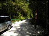 9
9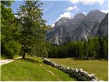 10
10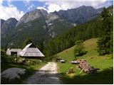 11
11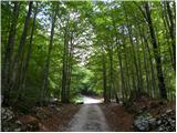 12
12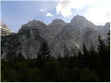 13
13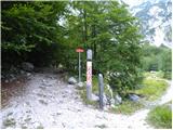 14
14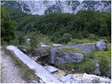 15
15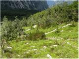 16
16 17
17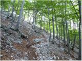 18
18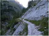 19
19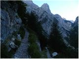 20
20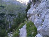 21
21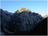 22
22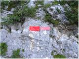 23
23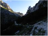 24
24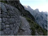 25
25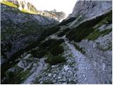 26
26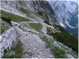 27
27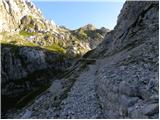 28
28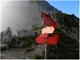 29
29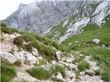 30
30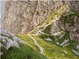 31
31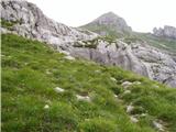 32
32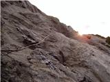 33
33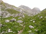 34
34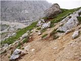 35
35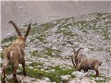 36
36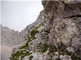 37
37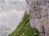 38
38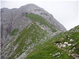 39
39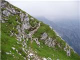 40
40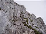 41
41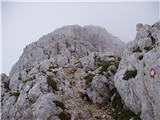 42
42 43
43
Discussion about the trip Zadnjica - Bovški Gamsovec (via Luknja)
|
| borlepadrino26. 08. 2015 |
I would like to go on a tour Zadnjica, Luknja, Gamsovec, Dovška vratca, Pogačnikov dom, Zadnjica. Does anyone have information about the paths and approximately how much time is needed for this tour. Is it doable with a dog??? I have full gear for self-belaying and conditioning for half marathon. Any reply and advice welcome
|
|
|
|
| borlepadrino26. 08. 2015 |
I'd like to go on a tour: Zadnjica, Luknja, Gamsovec, Dovška vratca, Pogačnikov dom, Zadnjica. Does anyone have information about the paths and approximately how much time is needed for this tour? Is it doable with a dog??? I have a complete self-belay kit and conditioning for a half marathon. Any reply and advice welcome.
|
|
|
|
| zokica27. 08. 2015 |
The tour is not for a dog, unless you want to get rid of it somewhere from the summit to Dovška vratca.
The path is fully marked throughout (a large part is the Slovenian transversal).
To Luknja 1.5 h, to summit 1.5 h, to vratca 45 min, to Pogačnik 44 min.
|
|
|
|
| buda127. 08. 2015 |
I agree with the previous one regarding the dog.
As for time, count good 3 hours to the Luknja and another 2 hours to the summit at normal pace.
|
|
|
|
| Apache27. 08. 2015 |
Depends on what kind of dog you have... and what experience you have with it in the mountains (altitude, rocks, stonefall,...). For dogs made for mountains, this is a piece of cake. If you haven't taken it to high mountains yet where you need to grip some details, better not take it. LP
|
|
|
|
| Nejc9326. 07. 2020 |
Via ferrata set on the path Zadnjica-Luknja-B. Gamsovec is practically not needed. Between Luknja and the summit the path is well secured with pegs at a few exposed spots. Steel cables total about 10 m.
|
|
|
|
| Tf5622. 06. 2021 11:36:58 |
Has anyone been to Gamsovec in the last few days, what are the conditions like?
|
|
|
To post a comment you must log in:
If you do not yet have a username, you must first
register.