Zadnjica - Glava v Zaplanji (via Dolič)
Starting point: Zadnjica (642 m)
| Latitude/Longitude: | 46,38240°N 13,76040°E |
| |
Route name: via Dolič
Walking time: 6 h 30 min
Difficulty: easy unmarked way
Elevation gain: 1914 m
Elevation difference along the route: 1950 m
Map: Triglav 1:25.000
Recommended equipment (summer): helmet
Recommended equipment (winter): helmet, ice axe, crampons
Views: 12.580
 | 5 people like this post |
Access to starting point:
From Kranjska Gora, drive over Vršič Pass towards Bovec or vice versa, but only to the 50th hairpin turn of the Vršič or Russian Road (near the village of Trenta). Here, turn onto the side road, along which after a few hundred meters we park at the parking lot by the road.
Route description:
From the paid parking lot in the Zadnjica valley, continue on the marked trail, initially along the road towards Pogačnikov dom at Kriške pode, Razor, Stenar, Križ, Bovški Gamsovec, Luknja, Triglav, Koča na Doliču and Kanjavec. The trail first leads past a few houses or weekend homes and after about 15 minutes of walking brings us to a marked junction where there used to be a free parking lot, but parking is now prohibited.
Continue along the slightly right lower road towards Zasavska koča at Prehodavci, Koča na Doliču, Luknja and other nearby objectives (left to Pogačnikov dom at Kriške pode and other goals above Kriške pode and the lower station of the cargo cable car to Kriške pode), where the gentle road leads through scenic meadows, higher through the forest. Just before the end of the forest road at the Planja junction or before the valley head in the area called Utro, a marked path to Prehodavci branches right.
Continue straight on the road, which soon becomes a footpath or old military mule track, along which we ascend mostly moderately on gradually steeper slopes. Still in the forest, the climbing path via Komar branches right; we continue on the mule track, which ascends in numerous hairpins, and due to steep slopes above, parts of the trail are exposed to falling rocks.
The fairly panoramic trail reaches about 1500 m at the next junction, where the path to Koča na Doliču branches right, straight ahead continues towards Luknja, Pogačnikov dom at Kriške pode and Triglav via Plemenice.
Continue right towards Koča na Doliču, ascending further on the mule track (to Luknja also via mule track).
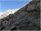
Further, mostly moderate ascent on the mule track across steep and occasionally exposed precipitous slopes. The trail is wide and well-built, technically not demanding, but exposed to falling rocks and due to occasional deep drops mostly unsuitable for vertigo sufferers. The trail occasionally zigzags, otherwise ascends diagonally right, gradually approaching the mighty Kanjavec wall.
Higher, the climbing path from Zadnjica via Komar joins from right, a bit further the Mira Marko Debelak path (via Kanjavčeve police) branches right. The increasingly panoramic trail makes a few more hairpins higher up and reaches a junction minutes before Koča na Doliču.
Continue left towards Triglav (straight to Koča na Doliču), shortly after the path past Koča na Doliču joins from right.
Here too take left on the trail and continue a while on the mule track leading north and ascending quite steeply. Higher the trail flattens and reaches Sedlo (2305 m), turning slightly left.
Followed by easy walking with superb views of Triglav and surrounding peaks, but caution due to high-alpine karst terrain to avoid holes or twisting ankles on scree.
The trail ahead ascends again, left branches the first unmarked path to Triglavska vojašnica Viktorja Emanuela III. (sometimes wrongly called Morbegna); we continue on the marked trail a while longer and head to the barracks at the next fork near the junction with the path from Plemenice.
Here go left on the unmarked path and in minutes reach Triglavska vojašnica Viktorja Emanuela III.
From barracks Viktorja Emanuela III. to the summit of Glava v Zaplanji only a few minutes ascent on the summit slope.
Starting point - Na placu 0:15, Na placu - Utro 1:00, Utro - junction for Komar 0:15, junction for Komar - Pod Skokom 1:10, Pod Skokom - Pod steno 1:25, Pod steno - junction before Koča na Doliču 0:55, junction before Koča na Doliču - Sedlo 0:30, Sedlo - Zaplanja junction 0:50, Zaplanja junction - barracks Viktorja Emanuela III. 0:10, barracks Viktorja Emanuela III. - Glava v Zaplanji 0:05.

Photos:
 1
1 2
2 3
3 4
4 5
5 6
6 7
7 8
8 9
9 10
10 11
11 12
12 13
13 14
14 15
15 16
16 17
17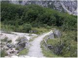 18
18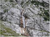 19
19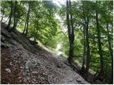 20
20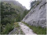 21
21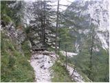 22
22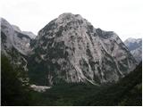 23
23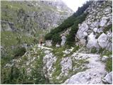 24
24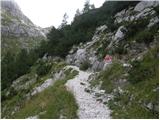 25
25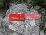 26
26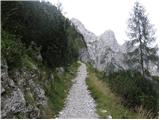 27
27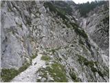 28
28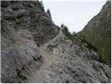 29
29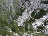 30
30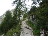 31
31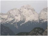 32
32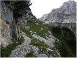 33
33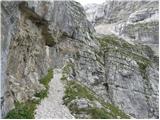 34
34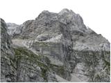 35
35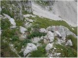 36
36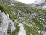 37
37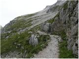 38
38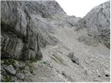 39
39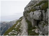 40
40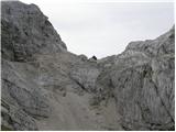 41
41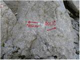 42
42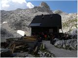 43
4344
 45
45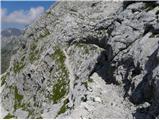 46
46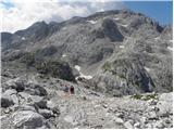 47
47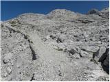 48
48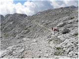 49
49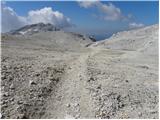 50
50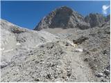 51
51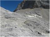 52
52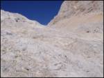 53
53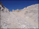 54
54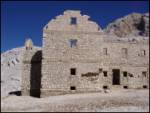 55
55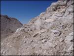 56
56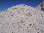 57
57
Discussion about the trip Zadnjica - Glava v Zaplanji (via Dolič)
|
| Gost26. 05. 2006 |
Where is the 50th switchback?? Only 49 are marked!
|
|
|
|
| Gost26. 05. 2006 |
Just for information. The mule track as well as the Morbegna fortress were built only a few years after World War I, when this territory was assigned to Italy by the Treaty of Rapallo (1920-1943). For overnight stays in the fortress, count at most as bivouacking in the open, but the object is planned for renovation in the future.
|
|
|
|
| Gost26. 05. 2006 |
49th or 50th, it doesn't matter anyway. Only one road leads to the Zadnjica valley anyway!
|
|
|
|
| Gost26. 08. 2006 |
Where does the news come from that Morbegna is planned for renovation?
|
|
|
|
| Gost8. 09. 2006 |
The 50th serpentine is at 645m, in the village Trenta, exactly at the place where you turn into the Zadnjica valley, we were there just yesterday, so I know 
|
|
|
|
| janez.novak1. 06. 2015 |
It's interesting that everyone calls this collapsing barracks Morbegna, in reality it was the barracks Caserma Vittorio Emanuele III, while Morbegna stood under Triglav (around where the turnoff to Kugyjeve police is) and was called Capano Morbegna and was a mountain hut.
|
|
|
|
| IgorZlodej1. 06. 2015 |
Did you happen to read the mountaineering gazette or did you fall for Italian propaganda archives 
|
|
|
|
| Branee1. 06. 2015 |
Yeah Igor, one is connected to the other (the publication in PV was largely based on archives)
|
|
|
|
| merkur2. 06. 2015 |
Well really - when the greatest experts in this area and topic are chiming in - what's the motive for Italian archival propaganda if they really care about it? And, on which (archival, written?) data was the knowledge about the name and position of the "kasarne Morbegna" actually based before what was written in PV? Thanks for the explanation!
|
|
|
|
| janez.novak2. 06. 2015 |
Igor - I read that in PV and I believed it. If I fell for it, I fell for it. Regardless of how it really was, the fate of this object is very sad.
|
|
|
|
| ana3. 06. 2015 |
Sad fate indeed, due to some individual
|
|
|
|
| IgorZlodej4. 06. 2015 |
Sad because they decided its fate in LJ.
|
|
|
|
| ana4. 06. 2015 |
I didn't know that they ordered a man from Lj to demolish those walls, but it is really logical because there was talk of rebuilding and the ruins were in the way.
After that, nothing came of it, just like from many other projects 
|
|
|
|
| merkur4. 06. 2015 |
I'm not entirely clear who should have decided the fate of that building - it was after all a state heritage from past times. About such and similar buildings, the state usually decides (our former one and the current one as well might have left it to collapse due to partial interests), but they are demolished by neither you nor me, just barbarically ignorant limited individuals. And nothing happens to them. Despair! They even proclaim themselves guardians of the high mountains and ultimately find support even among outwardly normal people ... Despair!
From the lines of some predecessors, one might sense that locals from nearby valleys should have decided about the barracks, so it is almost ironic that (perhaps?) "some Ljubljana people" first took the decision into their hands, and finally "some Jesenice guy" personally sealed its fate (literally).
|
|
|
|
| IgorZlodej4. 06. 2015 |
When some mothers were still wiping their last, it was decided whether to renovate the barracks at ZTP or go for the Kredarica merger. The latter prevailed, which has its seat in LJ , because it is the highest, so it had to be there where it is. All other commenting is completely superfluous, especially if under the influence of some celestial sign 
|
|
|
|
| GregorC4. 06. 2015 |
They did decide that way in Lj, but that doesn't mean it had to be demolished, as someone who is not from Lj is doing.
|
|
|
|
| Branee4. 06. 2015 |
The barracks was condemned to such an end because they simply didn't want the former occupying forces to have their monument on our symbolic mountain
|
|
|
|
| darinka44. 06. 2015 |
Exactly right, bravo Brane 
|
|
|
|
| janez.novak4. 06. 2015 |
I must stand up for my compatriot Lojze. He may indeed be demolishing the ruins of the barracks, which were condemned to decay after WWII.
|
|
|
|
| spartac31. 08. 2015 |
Above the barracks there's still some structure that surprisingly the tooth of time hasn't found, but we've decided to level it and then everything will be somehow in style
|
|
|
|
| B231. 08. 2015 |
Bravo! And on this occasion it would be good to simultaneously "level" the actor also, the demolisher of the excellent building and the "owners" of the plot (MNO RS Vojkova cesta 55, 1000 Ljubljana)! Let's finally remove this "idiot" from the Triglav National Park area! Isn't wild camping prohibited there?
|
|
|
|
| SuzanaM1. 09. 2015 |
Accommodation in a structure that has stood there for 90 years can hardly be called wild camping. In today's language, it's called squatting. If the owner doesn't mind someone living there for free in his building, there's nothing more to add. But since in this case the owner is the state, we can talk about damaging public property and criminal prosecution – not Lojze, but representatives of the indifferent state.
But who in all the entanglements in the Šentflorjanska valley would deal with high-mountain problems?
Three years ago I was at the collapsing fortress and I'm still sad about what I saw. Not because of Lojze, who diligently cleans up what falls from the ruins, but because of our country's attitude. When a building loses its roof, at such altitude it is mercilessly doomed to quick decay. The wild power of nature doesn't need human hands to level the structure with the ground in a few years.
But I just envy Lojze for arranging a bivouac at one of the most elite locations in Slovenia. With responsible owners with vision, a modern structure could stand here providing accommodation to all hikers.
|
|
|
|
| B21. 09. 2015 |
If there weren't Lojze and his "cleaning", the former very solidly built structure without any maintenance would stand for many more years and offer safe shelter to passers-by in case of bad weather! Neither the roof, nor the huge water cistern, nor the masonry collapsed on its own! Nothing to add here...
|
|
|
|
| mirank1. 09. 2015 |
Exactly as B2 writes. A good example are the former barracks at Lepoča h, where the buildings are missing practically only the roof, but they have the luck to lie lower than some famous one ...
|
|
|
|
| SuzanaM1. 09. 2015 |
The barracks at Lepočami are from the same period, but lie in a valley protected from wild weather. And these are also sadly decaying. No building has a roof anymore and certainly Lojz wasn't working here. I wouldn't seek safe shelter in such ruins.
|
|
|
|
| korl1. 09. 2015 |
Would everything collapse by itself yeah, come on? The pyramids in Egypt and the Parthenon in Athens are also slowly crumbling, yet no one helps them to become dust as soon as possible.
The fact is that a person deliberately demolished the building and many people saw him doing it, but no one acted
|
|
|
|
| BorStenar3. 12. 2022 23:25:26 |
Hi
is it possible to combine the hike with Triglav Pillar, if you continue from Morbegna Fortress towards Kugy Shelf?
LP
|
|
|
To post a comment you must log in:
If you do not yet have a username, you must first
register.