Zadnjica - Kanjavec (via Dolič)
Starting point: Zadnjica (642 m)
| Latitude/Longitude: | 46,38240°N 13,76040°E |
| |
Route name: via Dolič
Walking time: 6 h 35 min
Difficulty: difficult marked way
Elevation gain: 1927 m
Elevation difference along the route: 1950 m
Map: Triglav 1 : 25.000
Recommended equipment (summer): helmet
Recommended equipment (winter): helmet, ice axe, crampons
Views: 44.597
 | 2 people like this post |
Access to starting point:
From Kranjska Gora, drive over Vršič Pass towards Bovec or vice versa, but only to the 50th hairpin turn of the Vršič or Russian Road (near the village of Trenta). Here we turn onto a side road, along which we park after a few hundred meters at the parking lot by the road.
Route description:
From the paid parking lot in the Zadnjica valley, continue on the marked path, initially along the road towards Pogačnikov dom na Kriških podih, Razor, Stenar, Križ, Bovški Gamsovec, Luknja, Triglav, Koča na Doliču and Kanjavec. The path first leads past a few houses or weekend cottages and after about 15 minutes of walking brings us to a marked junction where there used to be free parking, but now parking is prohibited here.
Continue along the slightly lower right road towards Zasavska koča na Prehodavcih, Koča na Doliču, Luknja and other nearby objectives (left Pogačnikov dom na Kriških podih and other goals above Kriške pode and the lower station of the cargo cableway to Kriške pode), where a gentle road leads us further through scenic meadows, higher through the forest. Just before the end of the forest road at the Planja junction or before the head of the valley in the area called Utro, a marked path branches off to the right towards Prehodavci.
Continue straight along the road, which soon changes into a footpath or old military mule track, along which we mostly ascend moderately on gradually steeper slopes. Still in the forest, a climbing path via Komar branches off to the right, we continue along the mule track, which ascends in numerous hairpin turns, and due to the steep slopes above us, parts of the path are exposed to falling rocks.
The fairly scenic path brings us at an altitude of about 1500 meters to the next junction, where the path to Koča na Doliču branches off to the right, straight ahead the path continues towards Luknja, Pogačnikov dom na Kriških podih and Triglav via Plemenice.
Continue right towards Koča na Doliču and continue ascending along the mule track (towards Luknja also a mule track leads).
Further on we mostly ascend moderately along the mule track, which leads across steep and occasionally exposed precipitous slopes. Since the path is wide and well constructed it is technically not demanding, but it is exposed to falling rocks and due to occasional deep views mostly not suitable for vertigo sufferers. The path occasionally makes a few hairpin turns, otherwise it ascends transversely to the right most of the time, thus approaching the mighty wall of Kanjavec more and more.
Higher up, a climbing path from Zadnjica via Komar joins from the right, a little further the path of Mire Marko Debelak (path via Kanjavčeve police) branches off to the right. The increasingly scenic path higher up makes a few more hairpin turns, from it a path towards Triglav branches off to the left.
Continue straight, then quickly arrive at Koča na Doliču.
At the hut the path forks, we continue right downhill towards Kanjavec, where we descend towards the west (straight sedlo Dolič and Dom Planika pod Triglavom, Vodnikov dom na Velem polju, Hribarice...) and follow the marked alpine path. The descent ends quickly and we begin to ascend the rocky slopes of Kanjavec, with wider views opening with each step. Higher the path leads through a series of several indistinct valleys, above them we ascend transversely across a scree to the technically demanding part, where some fixed protections assist us. With the help of fixed protections we then ascend above the rock jump, the steepest part of the ascent is quite difficult as on a short section the path is very steep.
Above the jump the steepness eases and we join a technically easier path that leads over sedlo Hribarice.
Here we go right and quickly reach the panoramic summit of Kanjavec.
Starting point - Na placu 0:15, Na placu - Utro 1:00, Utro - junction for Komar 0:15, junction for Komar - Pod Skokom 1:10, Pod Skokom - Pod steno 1:25, Pod steno - Koča na Doliču 1:00, Koča na Doliču - Kanjavec 1:30.

Along the route: Na placu (714m), Utro (984m), Odcep za Komar (1058m), Pod Skokom (1494m), Pod steno (1899m),
Koča na Doliču (2151m)
Photos:
 1
1 2
2 3
3 4
4 5
5 6
6 7
7 8
8 9
9 10
10 11
11 12
12 13
13 14
14 15
15 16
16 17
17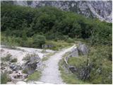 18
18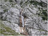 19
19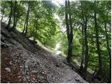 20
20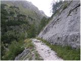 21
21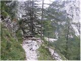 22
22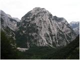 23
23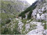 24
24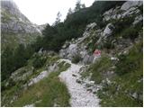 25
25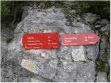 26
26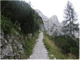 27
27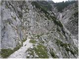 28
28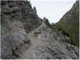 29
29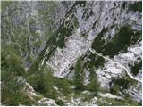 30
30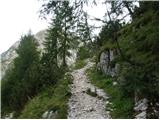 31
31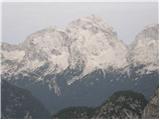 32
32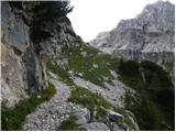 33
33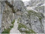 34
34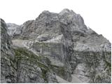 35
35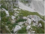 36
36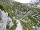 37
37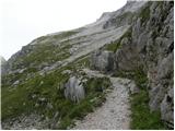 38
38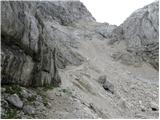 39
39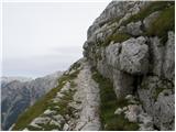 40
40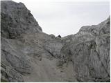 41
41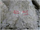 42
42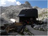 43
43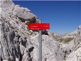 44
44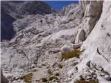 45
45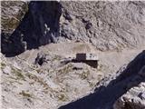 46
46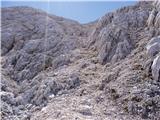 47
47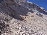 48
48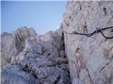 49
49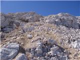 50
50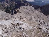 51
51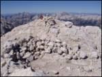 52
52
Discussion about the trip Zadnjica - Kanjavec (via Dolič)
|
| Jonny_7. 08. 2012 |
The path was in July 2012 very well marked, probably newly. Almost the whole path from Dolič onwards is just scree. The path has one very demanding section - almost vertical approx. 10 m cable on a somewhat exposed jump. Helmet here won't be superfluous.
|
|
|
|
| martabojan24. 08. 2015 |
Has anyone walked along the Kanjavec ledges recently, what is the trail like, is it secured, very dangerous????
Thanks for the info. Marta
|
|
|
|
| IgorZlodej24. 08. 2015 |
The trail along the Kanjavec ledges is of course not a walk, the trail is partially secured, but hands need to be used at some places.
|
|
|
|
| enjanez24. 08. 2015 |
We were there on Saturday. The safety gear, such as it is, is okay. But this trail is no walk, you have to watch every step. Good luck.
|
|
|
|
| panda24. 08. 2015 |
The topic is completely off-topic.
|
|
|
|
| martabojan25. 08. 2015 |
I used the word walk because that's what it says in the guidebook; otherwise, from the photos I gathered that the path is very scree-covered and the trail "sticks out", so I have doubts whether I would go to check it out. Last year I went via the ledges (Cerija Merlone), this year via Anita Gojtan, both variants are very nice to me, but could they somehow be compared, they seem more dangerous to me because there aren't as many safety features.
|
|
|
|
| IgorZlodej25. 08. 2015 |
Everything that belongs to Kanjavec is fine, including Kanjavec ledges or the path through Riža, as the path of Mira Marko Debelakova is also called. Also access paths from Zadnjica, or also from Veliko polje, Krma via Bohinjska vrata or from the Bohinj end. @Martabojan just cheerfully on the way, it is significantly easier than Ceria-Merlone and Anita, which you have already walked.
|
|
|
|
| panda25. 08. 2015 |
The topic of Kanjavec ledges (Path of Mira Marko Debelak) is already open. With a little patience and ingenuity, you could comment on it there. Under the Kanjavec topic it doesn't fit - because you don't go to the summit.
But I'm surprised at the admin that he fell asleep with moving the topic this time.  good morning. good morning.
|
|
|
|
| IgorZlodej25. 08. 2015 |
@panda first 10 times to the right via the approach over Komar, then counter via the approach over Zadnjški Dol, and sometimes in between to the top, and your heart will skip a beat 
|
|
|
|
| panda26. 08. 2015 |
@Zlodej: I've been on both paths already, but never directly to Kanjavec.
|
|
|
|
| lojz5. 10. 2017 |
Has anyone hiked through Hribarci in the last week? Is there still any snow there?
|
|
|
|
| mesargio5. 07. 2018 |
hi does anyone have any info on current conditions Dolič-Kanjavec snow etc? thanks
|
|
|
|
| bo_zl30. 07. 2018 |
On Saturday I walked the path Zadnjica-Dolič-Kanjavec-Prehodavci-Zadnjica. Up to Dolič there is still one snowfield and then from Kanjavec to Prehodavci another three or four. None pose a problem and all are passable without winter gear. However, the path from Kanjavec to Zasavska koča at Prehodavci up to the point where it joins the path over Hribarice is very poorly marked. Orientation caused problems not only for me but also for other hikers.
|
|
|
|
| darinka418. 08. 2019 |
Yesterday's ascent from Zadnjica to Kanjavec. And descent over Hribarice back to Dolič. And along the mulatiera to Zadnjica. Quite a long tour. But very beautiful. We hiked well. At 6:10 we set out. And at 12 we were at Kanjavec. Just before 18 in Zadnjica. With that, we spent about an hour at the summit. Now in summer the descent from Dolič along the mulatiera is quite hot. Parking lot completely full. It must have been even worse in Vrata.
|
|
|
|
| Grenaleva10. 09. 2019 |
Has anyone done a loop via Dolič up and Prehodavce down? Are the markers good? Thanks
|
|
|
|
| trdi23. 09. 2019 |
Poorly marked from Kanjavec down to the junction with the path from Hribarice, but it is traceable.
|
|
|
|
| Grenaleva24. 09. 2019 |
I went, it was nice weather and Prehodavci nicely revealed themselves. In fog it would be quite difficult from Hribarice to Prehodavci.
|
|
|
|
| MaksCuzak5. 07. 2024 18:06:16 |
The path was fun today, there's still a lot of snow, somewhere you need to cross a longer snowfield. Ice axe not needed, the path is well trodden.
Due to snow, navigation is more demanding.
|
|
|
To post a comment you must log in:
If you do not yet have a username, you must first
register.