Starting point: Zadnjica (642 m)
| Latitude/Longitude: | 46,38240°N 13,76040°E |
| |
Walking time: 3 h 25 min
Difficulty: easy marked way
Elevation gain: 1124 m
Elevation difference along the route: 1125 m
Map: Triglav 1:25.000
Recommended equipment (summer): helmet
Recommended equipment (winter): helmet, ice axe, crampons
Views: 21.733
 | 4 people like this post |
Access to starting point:
From Kranjska Gora, drive over Vršič Pass towards Bovec or vice versa, but only to the 50th hairpin turn of the Vršič or Russian Road (near the village of Trenta). Here we turn onto a side road, along which after a few hundred meters we park at a paid parking lot by the road.
Route description:
From the paid parking lot in the Zadnjica Valley, continue along the marked path, initially along the road towards Pogačnikov dom on Kriške Pode, Razor, Stenar, Križ, Bovški Gamsovec, Luknja, Triglav, Koča na Doliču and Kanjavec. The path first leads past a few houses or weekend cottages and after about 15 minutes of walking brings us to a marked junction where there used to be a free parking lot, but parking is now prohibited here.
Continue along the slightly right lower road towards Zasavska koča on Prehodavci, Koča na Doliču, Luknja and other nearby destinations (left to Pogačnikov dom on Kriške Pode and other destinations above Kriške Pode and the lower station of the cargo cableway to Kriške Pode), where the gentle road continues through scenic meadows, higher up through the forest. Just before the end of the forest road at the Planja junction or before the head of the valley in the area called Utro, a marked path branches right towards Prehodavci.
Continue straight along the road, which soon turns into a hiking path or old military mule track, along which we mostly ascend moderately on increasingly steeper slopes. Still in the forest, a climbing path branches right over Komar, but we continue along the mule track, which ascends in numerous hairpin turns, and due to the steep slopes above us, parts of the path are also exposed to falling rocks.
The fairly scenic path brings us at about 1500 meters above sea level to the next junction, where the path to Koča na Doliču branches right, and we continue straight towards Luknja, Pogačnikov dom on Kriške Pode and Triglav via Plemenice.
We continue ascending along the mule track, which leads above Koriti, and we follow the path, which is still partially exposed to falling rocks, to the marked junction at Luknja, where we join the path from the Vrata Valley starting point and from where a nice view opens to the other side.
Starting point - To the clearing 0:15, Clearing - Utro 1:00, Utro - Komar junction 0:15, Komar junction - Pod Skokom 1:10, Pod Skokom - Luknja 0:45.

Along the route: Na placu (714m), Utro (984m), Odcep za Komar (1058m), Pod Skokom (1494m)
Photos:
 1
1 2
2 3
3 4
4 5
5 6
6 7
7 8
8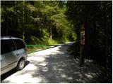 9
9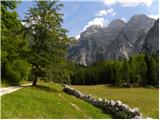 10
10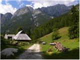 11
11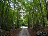 12
12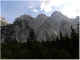 13
13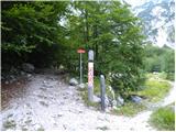 14
14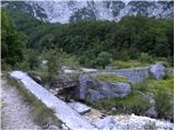 15
15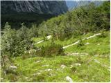 16
16 17
17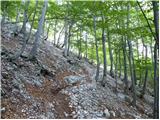 18
18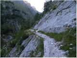 19
19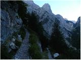 20
20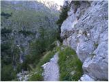 21
21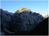 22
22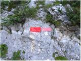 23
23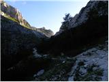 24
24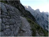 25
25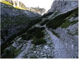 26
26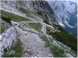 27
27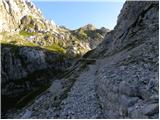 28
28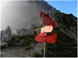 29
29
Discussion about the trip Zadnjica - Luknja
|
| amer20. 07. 2009 |
Does anyone know how from Luknja to Prehodavci - is the path easy or more demanding?
|
|
|
|
| SPIDER30. 08. 2012 |
Every year I go at least once along the mentioned path to Luknja and further. I always tell myself that I must write, the path is very poorly maintained. Especially from the junction to Dolič onwards. Debris is pushing from above, so next year we'll have to go on our knees further. At larger places it is sunken. I don't like to criticize, only autumn is the right time to renovate it easily after many years. The path is in the heart of Triglav though. Through Plemenice somewhere in the middle a peg is pulled out of the steel cable, but it does not endanger safe belaying. Good luck but no hard feelings.
|
|
|
|
| B230. 08. 2012 |
In my opinion, PD Gorje takes (no) care of this path. At least that's what it says on the directional signs along the path... The mentioned path has all the conditions to be an excellent mountain path (excellently built and preserved track of the Italian mule track) and with very little effort (cut the brush and patch the avalanche-damaged spots in a few places) it would remain so in the future. Unfortunately the story repeats itself and PDs that care for such nice paths do not want to hand over their "patronage" to other PDs that might want to manage and maintain the path, but cannot or are not able to do so themselves. Unfortunately that's how it is. Better that everything falls apart than that another PD appears here...
|
|
|
|
| IgorZlodej30. 08. 2012 |
I can say that I walk this trail quite often, and it's nowhere near the condition described above. Dwarf pine has overgrown here and there, but for now it's not critical. But I'll take a saw with me sometime, like I did last year on the trail through Komar . .
|
|
|
|
| SPIDER30. 08. 2012 |
Everyone sees it differently, that's nothing. Igor, just write to me on ZS when you're going, I'll gladly go with you and as they say "I'll lend you a hand."So that the Gorenci don't say how everything is overgrown on our (Primorska) side and everything is OK on theirs 
|
|
|
|
| urbancek30. 08. 2012 |
You should see the Presedljaj - Korošica trail in KSA. This one never, at least to my knowledge, was anywhere near what the dwarf pine did to that trail... I also hiked the mentioned trail from Doliča towards Luknja this year, and it wasn't anything so critical...
It is true that some things are cared for worse and worse... This is also seen in the "culture" that prevails in quite a number of summit logbooks in our mountains, and elsewhere... Lp!
|
|
|
To post a comment you must log in:
If you do not yet have a username, you must first
register.