Zadnjica - Triglav (via Dolič)
Starting point: Zadnjica (642 m)
| Latitude/Longitude: | 46,38240°N 13,76040°E |
| |
Route name: via Dolič
Walking time: 7 h 30 min
Difficulty: very difficult marked way
Elevation gain: 2222 m
Elevation difference along the route: 2245 m
Map: Triglav 1:25.000
Recommended equipment (summer): helmet, self belay set
Recommended equipment (winter): helmet, self belay set, ice axe, crampons
Views: 144.948
 | 7 people like this post |
Access to starting point:
From Kranjska Gora, drive over Vršič Pass towards Bovec or vice versa, but only to the 50th hairpin turn of the Vršič or Russian Road (near the village of Trenta). Here, turn onto the side road, along which after a few hundred meters we park at the parking lot by the road.
Route description:
From the paid parking lot in the Zadnjica Valley, continue along the marked path, initially along the road in the direction of Pogačnikov dom on Kriške pode, Razor, Stenar, Križ, Bovški Gamsovec, Luknja, Triglav, Koča na Doliču, and Kanjavec. The path first leads past a few houses or cottages and after about 15 minutes of walking brings us to a marked junction where there used to be free parking, but parking is now prohibited here.
Continue along the slightly right lower road in the direction of Zasavska koča na Prehodavcih, Koča na Doliču, Luknja, and other nearby destinations (left to Pogačnikov dom on Kriške pode and other destinations above Kriške pode and the lower station of the cargo cableway to Kriške pode), where the gentle road continues through scenic meadows, higher up through the forest. Just before the end of the forest road at the Planja junction or before the head of the valley in the area called Utro, a marked path branches right towards Prehodavci.
Continue straight along the road, which soon turns into a hiking path or old military mule track, along which we mostly ascend moderately on increasingly steeper slopes. Still in the forest, a climbing path via Komar branches right; we continue along the mule track, which ascends in numerous hairpins, and due to the steep slopes above us, parts of the path are exposed to falling rocks.
The fairly scenic path brings us to an altitude of about 1500 meters to the next junction, where the path to Koča na Doliču branches right, and straight ahead the path continues towards Luknja, Pogačnikov dom on Kriške pode, and Triglav via Plemenice.
Continue right towards Koča na Doliču and continue ascending along the mule track (the path to Luknja also follows a mule track).
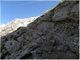
Further on, we mostly ascend moderately along the mule track, which leads across steep and occasionally exposed precipitous slopes. Although the path is wide and well-graded, technically not demanding, it is exposed to falling rocks and due to occasional deep views mostly unsuitable for those afraid of heights. The path occasionally makes a few hairpins but mostly ascends traversely to the right, gradually approaching the mighty wall of Kanjavec.
Higher up, the climbing path from Zadnjica via Komar joins from the right, a bit further on the path of Mira Marko Debelak (path via Kanjavčeve police) branches right. The increasingly scenic path makes a few more hairpins higher up and brings us to a junction a few minutes before Koča na Doliču.
Continue left towards Triglav (straight to Koča na Doliču), a little further the path passing by Koča na Doliču joins from the right.
Here too, go left; the path continues for a while along the mule track leading north and ascending quite steeply. Higher up, the path levels out and brings us to Sedlo (2305 m), where it turns slightly left.
A section of easy walking with a beautiful view of Triglav and surrounding peaks follows, but we must be careful due to the high-mountain karst terrain so as not to fall into a hole or injure our legs on the rocky ground.
The path ahead begins to ascend again, and an unmarked path to Triglavska vojašnica Viktorja Emanuela III (sometimes incorrectly called Morbegna) branches left; we continue skirting Glava v Zaplanji on the right eastern side, after which we join the path via Plemenice.
Head right towards Triglav and ascend over scree to the start of the climbing section, where we ascend transversely along the exposed wall on a well-protected path. Such a path brings us below the Triglavska or Bovška škrbina, then steeply up to the mentioned notch, where the Gorjanska pot from Planika joins.
Continue left upwards towards Triglav (straight down to Planika) along a steep but well-protected path. After a few minutes of further ascent, the steepness eases, and to the summit only a few minutes of walking along the summit slope of Triglav await.
Starting point - To the clearing 0:15, To the clearing - Utro 1:00, Utro - Komar junction 0:15, Komar junction - Below Skok 1:10, Below Skok - Below the wall 1:25, Below the wall - junction before Koča na Doliču 0:55, junction before Koča na Doliču - Sedlo 0:30, Sedlo - Zaplanja junction 0:50, Zaplanja junction - Triglavska škrbina 0:35, Triglavska škrbina - Triglav 0:35.

Along the route: Na placu (714m), Utro (984m), Odcep za Komar (1058m), Pod Skokom (1494m), Pod steno (1899m), Razpotje pred Doličem (2135m), Sedlo (2305m), Triglavska škrbina (2655m)
Photos:
 1
1 2
2 3
3 4
4 5
5 6
6 7
7 8
8 9
9 10
10 11
11 12
12 13
13 14
14 15
15 16
16 17
17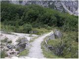 18
18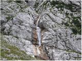 19
19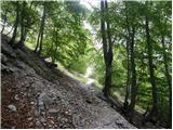 20
20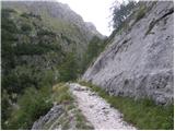 21
21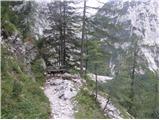 22
22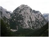 23
23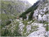 24
24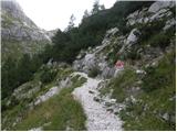 25
25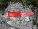 26
26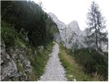 27
27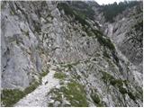 28
28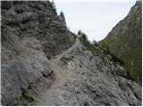 29
29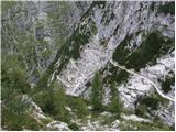 30
30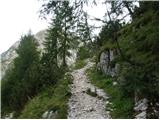 31
31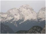 32
32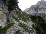 33
33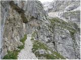 34
34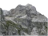 35
35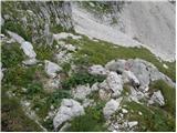 36
36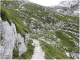 37
37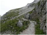 38
38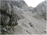 39
39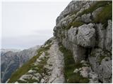 40
40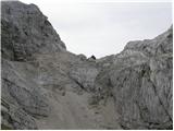 41
41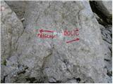 42
42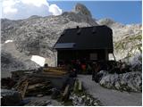 43
4344
 45
45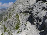 46
46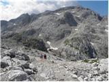 47
47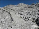 48
48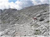 49
49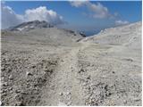 50
50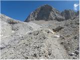 51
51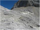 52
52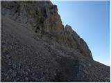 53
53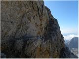 54
54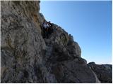 55
55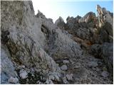 56
56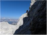 57
57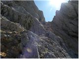 58
58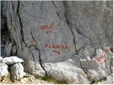 59
59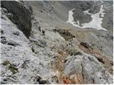 60
60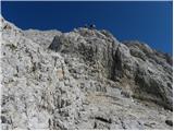 61
61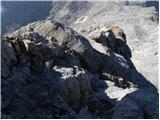 62
62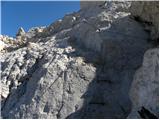 63
63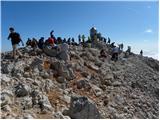 64
64
Discussion about the trip Zadnjica - Triglav (via Dolič)
Show older messages
|
| Gost21. 02. 2007 |
Hello! I am Damijan Sedej, who on 09 September 2006, in incredibly beautiful weather, played the entire path in 6 hours with an accordion accompanied by friends. With me they walked it for the first time, half of the participants, but this is the easiest path. On this path 800 incredible photos were taken
|
|
|
|
| Gost21. 02. 2007 |
Poor hikers who had to listen to this, since we go to the mountains to enjoy peace and quiet, and even more perhaps the poor animals living there who had to endure it.
|
|
|
|
| Gost22. 02. 2007 |
What hikers! Poor chamois and ibex, and ravens! What did they think of people?! Are the hills now for self-indulgence? I agree that we go to the mountains to enjoy peace and quiet in the sounds that nature sings: the whistle of the wind, the whistle of the chamois.... Maybe someone still remembers the old song: let the bird sing above Triglav, let the song flow... (not an accordion). Good luck to all! MiR
|
|
|
|
| Gost22. 02. 2007 |
G. Sedej! How can you disturb the peace in the mountains like that. You are uncultured and boast about it. Achieve records for playing the accordion in places prepared for that. (6 hours there is no record) Just take photos, but even 8 (really quality shots) will be enough in 6 hours. Set such records that you do not disturb the animals and us hikers. It's a pity that there are still many such Sedejs in our mountains. Better they sit at home. There do whatever you want, as long as the neighbors endure it....
|
|
|
|
| Gost24. 02. 2007 |
Those of you who go to Triglav for peace and quiet are really funny. Don't you think any other mountain would be more suitable than Triglav, where there are so many people that you have to wait in line when walking towards the top.
|
|
|
|
| Gost24. 02. 2007 |
That's true but Sedej disturbed the animals
|
|
|
|
| Gost24. 02. 2007 |
I liked the accordion though! There are no animals around here anyway. The "hikers" are even louder than them. The real hikers go elsewhere even though I have been to Triglav too. There was a crowd but it was still nice.
|
|
|
|
| Gost24. 02. 2007 |
"Real" hikers walk around there even when not climbing the "divine path - Triglav". There are many beautiful peaks nearby, on many (fortunately) there are no markings, so we usually meet there only "weirdos" who want peace along with beautiful views. And believe it or not, if someone in this area, even if not quite close or on the same path, plays village party for whole 6 hours, everyone around hears it well. That there are no animals there anymore is not true. Sometimes treat yourself to a trip in this area during the week, outside school holidays, and you will see it can be quite different than in summer on weekends.
|
|
|
|
| Gost24. 02. 2007 |
When I was on Triglav in August, I met at least five accordion players on the summit + two smaller ensembles on Kredarica. Damijan, if it's true that you played the entire path, I sincerely congratulate you. All true mountaineers know where to find peace in the mountains.
|
|
|
|
| Gost25. 02. 2007 |
No, I'm not pleased with your response! How you criticize me, Sedej, for disturbing the peace with the accordion. But I tell you, even the chamois watched and listened to me with interest. The caravan behind me walked in silence. Scientifically proven, music calms animals maybe more than us: Animals people!!!! You couch potatoes sitting at the internet surely don't have the energy to bring some corn or salt to these poor things in winter, at least at 1500m. I can't forgive you for just criticizing. So what, it's already an established practice that it's easier to criticize and drink beer. - For peace, you have to do more than go to Triglav on the highway ??????? If you're interested where, then write, at least those who don't go anywhere and criticize. Best regards Sedej
|
|
|
|
| Gost25. 02. 2007 |
In the mountains we are given silence and myth. I think those who disturb this peace do not belong in this environment. What suits animals, you Sedej certainly don't know, that's why you make such a racket. Don't impose the accordion on us, because we hear it from afar. Even if we avoid highways. Because of accordion players. You will do the most for peace if you leave the accordion at home and play in an environment suitable for it. How much anyone does (feeding) for animals, everyone knows themselves. How many couch potatoes there are (including you since you're on the internet), everyone knows themselves, better than you Mr. SEDEJ.
|
|
|
|
| Gost26. 02. 2007 |
I've been in the mountains a lot and I listen to Parni valjak with the greatest pleasure. Dear God, but I won't drag it to Triglav or elsewhere in the mountains for that. And how would accordion lovers feel with this music, even if Aki sang Jesen v meni and the like with all sentiment... Therefore: music on various instruments should be in the valley, in the mountains (even if it's "divine paths") let the wind sing for us. Good luck and no hard feelings.
|
|
|
|
| Gost28. 02. 2007 |
Sedej also missed the forum. I advise him to go to HARMONIKA, it's more interesting for him there. That's why he's afraid of competition. Or to LOVEC, there he'll learn a lot he doesn't know about animals (feeding at least at 1500m), what he missed.. Or to FOTO 800 photos in six hours. Too many because they're bad. Well, for Sedej they'll be good enough.
|
|
|
|
| Gost28. 02. 2007 |
Greetings from the "zapečkar", who was at Kredarica yesterday. I had a nice winter tour and lots of enjoyment. Thanks to all who weren't there yesterday, especially the harmonika players. Luckily those are summer self-proclaimed hikers. Fortunately in winter they fear for their fingers. Not all of us are some zapečkar like Damjan thinks. I wish you lots of enjoyment for pečjo.
|
|
|
|
| matjažg4. 03. 2007 |
All sorts of donkey 'hikers' have already carried all kinds of things to our Očaka. From stoves that they then donated to the hut, to fire brigade junk to photograph themselves at a higher point than Triglav, all bells and various instruments. It's true that peace is desired in the mountains. But why are you now attacking Damjan for wanting to play the harmonika. Isn't it nicer that he played harmonika on Triglav, at least other tourists in the valley and hikers in the mountains heard that there are friendly merrymakers in Slovenia among them. Not some steamroller that you could shove somewhere on Triglav with Aki.
|
|
|
|
| Gost4. 03. 2007 |
Agree with him and let it play for you if you like it. Give others PEACE.
|
|
|
|
| Gost4. 03. 2007 |
Matjažg, learn to read and you'll see what it says about the Steam Roller. I'm right with the guest in front of me. A trifle in a bunch of trifles.
|
|
|
|
| Gost4. 03. 2007 |
I can't rest without adding my comment on music and partying in the mountains. For many years I've been a regular guest in the mountains and never saw accordions and trumpets on paths and trails. What happens today is already TOO MUCH. One thinks maybe we're heading for Europe. I go to Grossglockner but no sign of the Sedlje. But if I look at past evenings at mountain huts, it was very lively years ago. You hardly experienced an evening without live music. People knew how to relax where it matters. In summer I stayed at Krn Lakes. In the evening you didn't know if you were at a funeral or if you did something wrong because no one spoke to anyone. I've experienced similar many times. I'm not saying it's everywhere, I'm saying we don't know what we want anymore and people have started to snap. Nice greetings to hikers who know in the morning why they go UP, especially greetings to touring skiers.
Jožko M.
|
|
|
|
| Gost25. 07. 2007 |
Unlike most others...Sedej, full respect. To play for 6 hours you need stamina like a horse, probably much more than all the other "soulful hikers". There are some plain idiots who think the mountains are created only for them and their peace. In the mountains you do what you want because they belong to everyone and no hiker has the right to complain if someone brings a bit of joy to the mountains so you don't have to listen only to your habits. If you like peace, rather learn to soundproof your apartment. 
|
|
|
|
| Gost25. 07. 2007 |
What if you two agree with Sedej and lock yourselves in a well soundproofed apartment and play as long and as loud as you want. Idiot is the one who doesn't respect nature, disturbs peace also to animals, forces people with noise. It's not true that you can do whatever you want in the mountains. What arrogant mindset. Joy in the mountains can be found in other ways, certainly not with 6-hour harmonica playing. That's why there are parties, whoever likes noise and harmonica goes there, other lovers of nature and beauty go to the mountains. There is peace and we are just visitors, so we must respect that. You don't have to listen to lectures, although some might come in handy for you.
|
|
|
|
| Gost25. 07. 2007 |
One really wonders what all creeps and tumbles on our mountains.
|
|
|
|
| Gost13. 08. 2007 |
To give people something to do, throw them a bone. You've been gnawing on the harmonica on Triglav bone all year. Sedej didn't intend to disturb the peace, but his group probably enjoyed themselves well on Triglav. As for disturbing the peace, as a hunter I observe chamois and ibex retreating, not to mention the capercaillie retreating to remote quiet areas, where conditions don't allow reproduction (now you can gnaw on the hunting bone, by the way, hunting isn't necessarily just about the gun, but also other things...). The cause isn't the harmonica, but crowds of people, mountain bikers and general civilization noise (by the way, you have a bone about the civilized world and uncivilized hunters). Besides that, I recommend a cultured visit to the mountains to everyone, such a visit can be accompanied by a harmonica, which no expert can play the entire way to Triglav on pitons. One more thing - carry out trash to the valley, as it's a reflection of your culture and positive attitude towards nature. To add at the end, I also play the harmonica. Now your comments, which you'll discuss next year.
|
|
|
|
| Gost13. 08. 2007 |
Well, let's gnaw on this hunting bone
I believe it bothers hunters that animals retreat to more inaccessible areas and don't reproduce where hunters can reach them - since the basic purpose of hunting is killing - so at least somewhat "affected". And that pleases me greatly, they don't retreat much in front of me (who doesn't walk through forests and hills with a rifle on shoulder or in hands).
Stop preaching about nature conservationists who admire and protect nature with a gun. If it's about nature protection, join some animal protection society or ecological association.
|
|
|
|
| Gost13. 08. 2007 |
better on accordion than on violin.
|
|
|
|
| Gost13. 08. 2007 |
to Slovenian mountains with Slovenian music!!!
|
|
|
|
| Gost13. 08. 2007 |
Avsenik on Goblek. So there will be enough noise.
|
|
|
|
| Gost13. 08. 2007 |
I agree with Slovenian music, but the writer before me probably doesn't know much about it - if he thinks that Slovenian folk songs are "jingles" on accordion, he's badly mistaken. The accordion and tingl-tangl is a much later invention of the Alpine region of Europe and not Slovenian at all (though it's true that Avsenik perfected the genre).
|
|
|
|
| Gost13. 08. 2007 |
A hunter yelled at me for walking past the feeding spot and scaring the game. But he arrived at the feeding spot on a moped that was rattling and making noise ten minutes before he got there. I was walking quietly and silently on foot to see some animal. All just talk. And with a rifle of course.
|
|
|
|
| Gost13. 08. 2007 |
Hunters are no longer what they used to be. Raubšič shot only enough for the pot, otherwise he respected nature and animals. What about today? Money, money and trophies.
|
|
|
|
| ranc13. 08. 2007 |
How happy I am that such things happen on the way to Triglav. We have at least one mountain where some can relax, elsewhere it's more peaceful and nicer, and that's where I am!
|
|
|
|
| Gost14. 08. 2007 |
Hehe, were you the one with whom we waved to each other from afar last time, each from the top of neighboring mountains without marked paths! 
|
|
|
|
| Gost28. 08. 2007 |
Hello!
Don't you think that rather than indignation over the accordion player, some opinion about the trip would fit here?
We would like to go to Triglav via this path with the family, and I'm interested in how demanding it is. And maybe someone could send a photo from the path...
Nice mountain greeting - and don't forget - excitement harms health!!
|
|
|
|
| Gost28. 08. 2007 |
Well, what's missing from the path description and the numerous photos posted here?
The topic you mention, as you can see, has already been concluded and I really don't see the reason why you try to "revive it from the dead".
|
|
|
|
| Tadej28. 08. 2007 |
When the guest asked for photos, they weren't there yet. They were posted between the two comments. Lp
|
|
|
|
| Gost13. 09. 2007 |
It's now high time someone answers the question about the path's difficulty.. Is it also suitable for children (to the hut at Dolič)?
|
|
|
|
| Gost13. 09. 2007 |
A year has already passed since Sedej's feat (To Triglav with an accordion). Memories are beautiful, effort is forgotten, the feat (record) remains and tickles many
Best, Tine
|
|
|
|
| Gost14. 09. 2007 |
From Zadnjica to Dolič there is the so-called mulatjera. Still, you have to be careful, especially if children are too "lively". They can easily slip on the scree. If there are children in the group, a piece of rope in the backpack is never too much. But this path from Zadnjica to Dolič is long. For children, a nicer and more suitable path is from Pokljuka to Planina Konjščica (in summer season livestock grazes here) and to Velo polje, then along Velska dolina to Dolič. Good luck!
|
|
|
|
| Gost14. 09. 2007 |
Rope in the backpack is of very little use, we just carry a bit more weight.
|
|
|
|
| Gost14. 09. 2007 |
Maybe he meant "upbringing with a rope" along the path.
|
|
|
|
| Gost14. 09. 2007 |
Maybe he'll tie up the dog?
|
|
|
|
| Gost14. 09. 2007 |
We've already discussed dogs in the mountains! No, please, not again!!!!!!!!!!!
|
|
|
|
| Gost23. 09. 2007 |
Yeah, you're all the tough guys who write these comments
|
|
|
|
| Gost29. 09. 2007 |
On September 7th I set off from Zadnjica along the Komarjeva path to Dolič and onwards to Triglav. The end of the path was right after the saddle towards the summit. 1m of snow. Nowhere did I notice if those 100 women made it to the summit this year? Conditions were poor.
|
|
|
|
| ana14. 07. 2008 |
I would praise the staff at Tržaška koča at Dolič, they are very friendly.
|
|
|
|
| Nickster21. 07. 2008 |
I'm new here but don't get mad if I say something about Sedej and the accordion. MOUNTAINS ARE NOT FOR MESSING AROUND WITH ACCORDION! YOU CAN EASILY SLIP
INTO YOUR A*. YOU ENDANGER OTHERS TOO!!!
Lp
|
|
|
|
| petruša23. 08. 2009 |
On 10.8.2009 we went from Zadnjica via Dolič to Triglav. Besides me and my husband, children aged 9 and 10 also went. The path is very nice and suitable for children. We started from Zadnjica at 6:00, back the same day at 19:35, a bit tiring but doable, children were very happy to conquer Triglav.
|
|
|
|
| heinz26. 08. 2009 |
Petruša, did you have the children roped up?
|
|
|
|
| petruša27. 08. 2009 |
I had the children tied with a rope, because you never know what can happen
|
|
|
|
| MaticMrva23. 03. 2010 |
You guys are really funny with some comments. I do agree with those who say it should be hiked in peace and quiet - don't mess around. In a few years, they'll be driving trolleys to Triglav. For peace and quiet, there are much nicer, especially quieter paths. Regarding the accordion, that instrument really isn't for the mountains, or any instrument. But if we exclude that the accordion is national pride, Triglav is national pride, and we are proud of Slovenian stupidity, it was probably nice to hear it at the top....
|
|
|
|
| IgorZlodej24. 03. 2010 |
Depends on when you go up. I've been at least 100 times on the path Zadnjica - Dolič - Triglav or Zadnjica - Luknja - Triglav completely alone and didn't meet anyone, or just one or two. So there you can still find plenty of silence and genuine peace.
|
|
|
|
| turbo24. 03. 2010 |
Or, if you have fast legs, from Zadnjica first to the saddle (pass) via Dol pod Zadnjiškim Ozebnikom, from there to Prehodavci and along the ledges under Kanjavec to Dolič. All the way to Dolič, except for the hut at Prehodavci, there won't be any crowds. Then up and down from Dolič, descent to Zadnjica via Komar. And you have a great tour without fear of crowds!!!
And no trols and accordions 
|
|
|
|
| trinity9. 06. 2010 |
Hi, maybe some fresh information... how much snow is left??
LP
|
|
|
|
| turbo9. 06. 2010 |
Fresh info second-hand: snow is still there . . . . just right!
PBZ (no hard feelings)
|
|
|
|
| trinity9. 06. 2010 |
I know it's a bit silly question....and I'm not reluctant to take crampons and ice axe. But our little boy is coming with us...and tours are adapted to him. If there's still a lot of snow we'll go in August instead....
|
|
|
|
| trinity10. 06. 2010 |
I saw the pictures...and it looks like there's just the right amount of snow.....hehehehe
|
|
|
|
| spotonbody10. 06. 2010 |
I'm also interested in the conditions right from the Zadnjica starting point to the nearby ''hills'' Kriški podi... and further, approximately how much snow is left, considering it snowed in the Julijcih even last month ...
@trinity: which pictures?
|
|
|
|
| spotonbody10. 06. 2010 |
already found the pics, all clear! we'll wait a bit longer for the highest hills
|
|
|
|
| dj1210. 06. 2010 |
Where are the pictures - where there's still snow.....just right...
|
|
|
|
| lencka9. 07. 2010 |
Tomorrow we're heading via Prehodavci to Kanjavec, then to Dolič. How much snow is there?
|
|
|
|
| lencka9. 07. 2010 |
We would go on Sunday further to Triglav. If anyone has fresher info on the path condition and especially snow, please let me know.
|
|
|
|
| funnyboy9. 07. 2010 |
From Prehodavci to Kanjavec there are snow fields but not dangerous. From the summit towards Dolič we didn't go because we were told there are dangerous snow fields. On the descent from Dolič towards Zadnjica there are 3 snow fields. Caution required! We didn't have ice axes and it went fine.
|
|
|
|
| lencka9. 07. 2010 |
Thanks, funnyboy!
We also don't have ice axes, nor crampons. We only go to the high mountains in the summer months, but this year winter was really long.
|
|
|
|
| mizuno13. 08. 2010 |
We plan to hike the path from Dolič to Triglav; please provide a precise path description if someone knows it.
P.S. is the path also suitable for children.
|
|
|
|
| IgorZlodej13. 08. 2010 |
Described 101 times already, just click around a bit. Of course over the wall or through Triglav Notch you need to use the protections. The route from this side is considered the easiest to Triglav, but that's subjective. If children are not used to walking on protected paths they will of course have lots of trouble, it might end already on the first meters of ascent because there are two exposed traverses. In any case, proper rope belaying of children is recommended, and due to possible falling rocks helmet use as well.
|
|
|
|
| jany19804. 01. 2012 |

Reading comments....
Wonder how they would comment if the late Mr. Slak played for 10 hours on top of Triglav....
Let the accordion be the symbol of Slovenian music, not those who are bothered!
|
|
|
|
| ivona4. 01. 2012 |
What are you talking about Jany...?
|
|
|
|
| GregorC4. 01. 2012 |
About the first comment in the thread...
|
|
|
|
| ivona4. 01. 2012 |
Oops, I really wasn't paying attention to the almost five-year-old comments
But I too have come across some such parties with accordions and the like in our huts and I don't want any more of it...
|
|
|
|
| jany19805. 01. 2012 |
Depends on the individual.
Personally, I prefer to hear the sound of an accordion in the mountains rather than modern rhythms....
to each his own
And precisely Slovenes, for whom the "alleged" accordion is a domestic instrument, are rebelling here....
|
|
|
|
| turbo5. 01. 2012 |
Any noise in the mountains is annoying. The same goes for those who make it.
|
|
|
|
| IgorZlodej5. 01. 2012 |
@turbo I completely agree. After all, we go to the mountains for peace, silence, bird song, sunrises and sunsets, which are most beautiful precisely at the time when silence plays. We have enough of everything else in the valley. Well, unfortunately we can't always avoid the accordion either, and if there's a flute girl nearby, the old goats would still spin.
|
|
|
|
| planika507. 01. 2012 |
Our Slovenian accordions really open all doors and are welcome in many places as part of the atmosphere in company, and some pleasant playing at a mountain hut probably doesn't harm anyone. Peace, quiet and everything else that somehow belongs in the mountains and for which we like to go to this wonderful world has simply changed over the years and with the way of technological life. Today we see many things in the mountains that simply don't belong there and there's far too little education in terms of movement and etiquette in the mountains. Perhaps a guideline for some comments on this portal, which is simply intended for information and pleasant experiences and impressions of mountaineers/hikers. Someone asks a slightly awkward question, an extreme thought in movement, and then the typical negative comments start.
|
|
|
|
| Pohodnica5623. 02. 2012 |
Indeed, it's already a month or more ago, actually years about this "horror" accordion, but I'll still add a bit to the fire. Why on earth doesn't it bother anyone when the "horror" accordion plays in the huts and no one complains that it's annoying. And when everyone loudly demands their well-deserved beer, but that's not annoying.... and more could be found. A few chords are an atrocity. Let's be a little less egoistic and negative, everyone can find a corner of peace and quiet.
|
|
|
|
| Lara824. 06. 2012 |
This Friday we're heading to Triglav. Up from Rudno polje, down via Dolič. But do you perhaps know what the current conditions on Triglav are like? Snow and such? And what are both paths like? Thanks!
|
|
|
|
| joža x22. 07. 2012 |
Those who like the accordion are disturbed by "hikers" trudging off trails, those who like ski touring are disturbed by snowmobiles, true hikers are disturbed by tourists in the mountains, hunters (including me) are disturbed by dogs in the mountains, those who like peace are disturbed by merrymakers.....Yeah, everyone sees the other, but how they themselves affect nature and disturb others doesn't bother them .......
|
|
|
|
| Alpski Slovenc22. 07. 2012 |
Hello. Since the last post here on hribi.net, my wife and I have hiked and summited quite a few peaks. We started our two-day tour in the afternoon after 4 PM from Zadnjica. After four hours of walking on the mulatiera, we overnighted at the Tržaška koča at Dolič (staff very friendly, prices quite high for our conditions, I think the highest around there) and headed to Triglav the next morning. From the hut at Dolič, we continued left on the mulatiera and ascended. After 45 minutes of walking, the path levels out and we have a nice view of our goal Triglav ahead. We continue towards Triglav over the scree slopes, past Lojzet, to the junction where the path from Plemenice joins. We go right up the scree to the wall and then with the aid of fixed protection cross up to the Triglavska škrbina (here the path from Planika joins). We continue left up the steep well-protected path (right at the start of about 100m ascent there are two loose pitons, one larger, one smaller, which need securing). All the way to the summit along the southern slopes of Triglav, a strong wind blows in gusts, driving fog from the valley of Trenta. From the direction of Kredarica to the summit and back, there was quite a bit of traffic visible. At the summit, fog greets us first. Soon it clears for a few minutes and I take photos all around. After a one-hour rest and the obligatory baptism of my wife, who celebrated her birthday that day, we slowly descend along the Triglav ridge towards Dolič and further to Zadnjica in Trenta.
|
|
|
|
| tiasha14. 08. 2012 |
It would be much nicer if everyone stopped worrying about such pointless things and instead enjoyed the moment, savouring every given instant. Instead of everyone arguing all over the place about the accordion. Come on, don't mess around!
|
|
|
|
| Svoboda28. 07. 2013 |
Nice mountain greetings. At the beginning of the week, we are heading out on this trail. Does anyone perhaps know what the current conditions on the trail are like, any peculiarities?
|
|
|
|
| tindi27. 09. 2013 |
I'm wondering if anyone knows how long the path from Zadnjica via Dolič to Triglav is? Thanks for the answer! LP T
|
|
|
|
| IgorZlodej27. 09. 2013 |
I don't know in km, although I've walked it more than 300 times, time-wise everyone has to find out for themselves, as far as I remember 3.5 hours last time.
|
|
|
|
| joža x27. 09. 2013 |
Everything is written on the top of the page, except km, for those who go by bike.
|
|
|
|
| bruny27. 09. 2013 |
There should be just under 10 kilometers -  , more precisely 9735 meters, positive elevation 2372 and negative 220. Regards , more precisely 9735 meters, positive elevation 2372 and negative 220. Regards
|
|
|
|
| ben27. 09. 2013 |
Where do you get 220 down from?
|
|
|
|
| Matic2529. 07. 2014 |
How are the snow patches currently on this route?
|
|
|
|
| ajax29. 07. 2014 |
Be quiet and make an effort, you'll see.
|
|
|
|
| lucylucy18. 08. 2015 |
I also visited the Zadnjica valley and the waterfall.
But I was most surprised by the radars that were issuing tickets to all cars whose owners didn't park their steel horses properly and missed the sign. So, when you drive into the Zadnjica valley and see a parking spot, park if you don't want to get a ticket.
|
|
|
|
| darinka41. 09. 2015 |
I also got a ticket and all who parked by the barrier that day. Then I left the car at the lower parking lot. The sign that you mustn't park at the barrier disappeared later, now at least I didn't see it. The last part of the path drags the most, on descent.
|
|
|
|
| planika7718. 04. 2016 |
I'm interested in which is the easiest path to Triglav or the most suitable for those prone to vertigo (not overly vertigo-prone, but still a bit ). Is the one from Zadnjica via Dolič the most suitable, or from Krma via Planika or from Pokljuka via Planika? Which one do you recommend? Thanks to everyone in advance!
|
|
|
|
| darinka418. 04. 2016 |
Depends on where you are from? For me the easiest is the one from the Primorska side from Zadnjica to Dolič. It's not really exposed at all. You just need fitness.
|
|
|
|
| planika7718. 04. 2016 |
Oh, I have fitness for export and I'm not afraid of heights in general, as long as there's somewhere to step I just don't like overly exposed/aerial sections...
|
|
|
|
| tropine18. 04. 2016 |
Both from Pokljuka and Krma are safe and not dangerous.
Personally I would choose from Pokljuka. My recommendation is the path from planina blato above sedmerimi DOLIČ-PLANIKA -TRIGLAV, very nice tour. l.p. and safe steps
|
|
|
|
| jax18. 04. 2016 |
Oh, for God's sake, not from Pokljuka! That's the best recipe for never going to the mountains again. It drags on like a chicken's gut and you'll hardly forget the descent... Of the listed ones, I'd most recommend Zadnjica, otherwise consider Kot as well.
|
|
|
|
| zippo19. 04. 2016 |
Either one or the other, there's no essential difference. More important to choose the right time, so you don't go already now for the May Day mountain rush!
|
|
|
|
| redbull19. 04. 2016 |
For May Day better not, there might be a crowd. You probably meant that zippo
|
|
|
|
| zippo19. 04. 2016 |
that's what you meant brihta
|
|
|
|
| vanya3. 07. 2017 |
Hello! I'm also interested in which is the easiest route to Triglav or the most suitable for the vertiginous (not too vertiginous, but still, a bit of blinking ) Is the most suitable this one from Zadnjica via Dolič, or from Krma via Planika or from Pokljuka via Planika? Which one do you recommend?
|
|
|
|
| ločanka3. 07. 2017 |
None is suitable for the vertiginous.
|
|
|
|
| smatjaz3. 07. 2017 |
The most "humane" route is from Krma Valley to Planika, then the path for those afraid of heights ends.
|
|
|
|
| korl3. 07. 2017 |
vanya, you're talking about approaches to Triglav, regardless if you start from Pokljuka, Krma or Zadnjica, those paths lead only to the foot of the summit section, onwards it's precipitous from all sides and with the aid of pegs...
|
|
|
|
| hribuc854. 07. 2017 |
For the ascent to Triglav, based on the above it seems to me the most suitable path is from Dolič which starts on the mulatiera. Mainly because no need to cross Pasji greben between Mali and Veliki Triglav. The path doesn't seem so exposed to me. But I'd recommend some smaller "training" summit before Triglav where vertigo can be eased or eliminated. Pogačnikova to Šmarna Gora or Furlanova to Gradiška Tura,... These are shorter paths where "diagnosis" for high mountains is set. But that's just my lay opinion.
Good luck!
|
|
|
|
| ejas12341. 08. 2020 |
Hello.
How is the path to Triglav via Dolič.
Is helmet and harness needed in the last part.
thanks for the answer.
|
|
|
|
| Sammer 13. 09. 2020 |
I was on this path yesterday 12.9. and recommend a via ferrata set and mandatory helmet. No crowds on this side. Not for those prone to vertigo.
|
|
|
|
| trdi13. 09. 2020 |
It's true, this path is also not for those prone to vertigo. If anyone thinks they'll avoid the dizzying ridge between Mali and Veliki Triglav with the path from Dolič, I warn that shortly after entering the wall there's a very exposed parametric section where you step on a peg carved into the rock, with a precipice below. This part is more exposed than anything on the ridge between the Triglavs. Otherwise, apart from that and the initial entry with pegs, the path isn't particularly demanding. But it's quite demanding for descent, so I recommend descending to Planika and then returning to Dolič from Planika. This path is exceptionally beautiful.
I'd also comment on the access to Dolič. The climbing path over Komar is exceptionally beautiful, two cables need repair, a few pegs are loose. I don't understand why the branch for Komar at the bottom of the valley isn't marked. As if they were hiding this path, even the cairn at the branch was knocked down and I fixed it. On the return from Dolič to Zadnjica along the "easy" mule track, I would personally mark this path as partially demanding, as the upper part is a bit exposed, and two small scree slides need clearing, which are quite dangerous to cross.
|
|
|
|
| matija9611. 07. 2021 22:11:36 |
Hi, does anyone know if the Triglav-Dolič trail is already passable or if winter gear is still needed? Thanks and best regards
|
|
|
|
| Nortg30. 07. 2021 10:46:03 |
The trail is passable without winter gear. Below the hut at Dolič there is still some snow but it causes no problems and winter gear is not needed, I recommend only hiking poles. lp
|
|
|
|
| jupenima28. 03. 2022 12:46:42 |
Hello,
does the path go past (or near) the ruins of the Triglav mountain barracks (of King) Vittorio Emanuele III (or Morbegne, as it's apparently wrongly called)?
|
|
|
|
| bongo28. 03. 2022 18:48:16 |
Hi, the upper one goes, stick to the left path or mule track that goes towards Glava peak in Zaplanja. The junction is about an hour from Dolič, I think you can't miss it, but if you do, you can return at the junction for over Plemenice and the summit. You'll probably be disappointed by what's visible though.
|
|
|
|
| jupenima29. 03. 2022 09:41:47 |
Thanks for the reply, maybe I'll go take a look.
|
|
|
|
| darinka421. 08. 2023 05:55:50 |
We were there yesterday with Maksij. Wonderful Sunday. We walked the entire trail in the shade. Not many hikers from this side. No August crowds on the summit either. And the wind was cooling as forecasted. We descended the ascent route. Stopped at Justi and Vinkot. Some vehicles in the Zadnjica parking had ranger notices stuck on the windshield. The hiker I talked to said you can pay parking with a bank card. Otherwise very few cars parked for a Sunday.
|
|
|
|
| darinka41. 09. 2025 08:13:13 |
After two years Maksij and I set out on Sunday, last day of August. Started hiking from Log in Trenta. No crowds from this side. Nor on descent. Otherwise bustle from Kredarica and Planika. At the top you don't feel like you're on our highest peak due to many foreigners waiting to photo in front of the tower. Weather yesterday just right for hiking. Hiked whole path in long sleeves.
|
|
|
To post a comment you must log in:
If you do not yet have a username, you must first
register.