Zadnjica - Triglav (via Komar)
Starting point: Zadnjica (642 m)
| Latitude/Longitude: | 46,38240°N 13,76040°E |
| |
Route name: via Komar
Walking time: 7 h 10 min
Difficulty: very difficult marked way
Elevation gain: 2222 m
Elevation difference along the route: 2235 m
Map: Triglav 1:25.000
Recommended equipment (summer): helmet, self belay set
Recommended equipment (winter): helmet, self belay set, ice axe, crampons
Views: 31.527
 | 2 people like this post |
Access to starting point:
From Kranjska Gora, drive over Vršič Pass towards Bovec or vice versa, but only to the 50th hairpin turn of the Vršič or Russian road (near the village of Trenta). Here, turn onto a side road, along which after a few hundred meters we park at the parking lot by the road.
Route description:
From the paid parking lot in Zadnjica valley, continue on the marked trail, initially along the road towards Pogačnikov dom on Kriški podi, Razor, Stenar, Križ, Bovški Gamsovec, Luknja, Triglav, Koča na Doliču and Kanjavec. The trail first leads past a few houses or weekend cottages and after about 15 minutes of walking brings us to a marked junction where there used to be a free parking lot, but parking is now prohibited here.
Continue on the slightly right lower road towards Zasavska koča na Prehodavcih, Koča na Doliču, Luknja and other nearby objectives (left to Pogačnikov dom on Kriški podi and other goals above Kriški podi and the lower station of the cargo cable car to Kriški podi), where the gentle road continues through scenic meadows, higher through the forest. Just before the end of the forest road at the Planja junction or before the valley head in the area called Utro, a marked path branches right towards Prehodavci.
Continue straight along the road, which soon turns into a footpath or old military mule track, along which we mostly ascend moderately on gradually steeper slopes. Still in the forest, on the section where the mule track turns left, the climbing path via Komar branches right or straight ahead.
The inscription “Komar” on the rock directs us straight onto a narrow path that leads across a meadow towards a small stream. The path then crosses the stream and begins ascending the steep slope towards the chapel, which we can already see ahead. At the chapel, the path turns right and with the aid of some cables crosses the steep slope to the west during the ascent. The path then brings us to a torrent gully along which we ascend left upwards with the help of protections. After a short ascent, we leave the gully and head right onto a narrow secured ledge that brings us to the steep northern slopes. There follow some steep ascents along cables, then the path turns slightly left and begins to cross exposed slopes in a slight ascent. Such a path brings us into another torrent gully along which we then ascend with the help of protections. This time we leave the gully on the left side, followed by a short crossing along cables that brings us to less steep slopes covered with dwarf pines and shrubs.
Continuing with beautiful views towards Pihavec and Zadnjiški Ozebnik, we ascend mostly through dwarf pines. Such a path brings us to grassy slopes, in the upper part becoming increasingly scree-covered. When already very close to the walls of Kanjavec, the path turns left followed by a short ascent to a junction where we join the usual path along the military mule track.
Continue along the mule track, a little further the path of Mira Marko Debelak (path via Kanjavčeve police) branches right. The increasingly scenic path higher up makes a few more switchbacks and brings us to a junction a few minutes before Koča na Doliču.
Continue left towards Triglav (straight to Koča na Doliču), a little further the path via Koča na Doliču joins from the right.
Here too go left and continue along the mule track for some time, which leads north and ascends quite steeply. Higher up the path levels out and brings us to Sedlo (2305 m), where it turns slightly left.
There follows some easy walking with a superb view of Triglav and surrounding peaks, but we must be careful due to the high-alpine karst terrain, so as not to fall into a hole or injure our leg on the scree terrain.
The path ahead begins ascending again, to the left an unmarked path branches towards Triglavska vojašnica Viktorja Emanuela III. (sometimes incorrectly named Morbegna), while we continue along the right eastern side bypassing Glava v Zaplanji, after which we join the path leading over Plemenice.
Head right towards Triglav and ascend over scree to the start of the climbing section of the path, where along a well-protected path we ascend transversely on the exposed wall. Such a path brings us under Triglavska or Bovška škrbina, then we ascend steeply to the mentioned notch, where Gorjanska pot from Planika joins.
Continue left upwards towards Triglav (straight down to Planika) along a steep but well-protected path. After a few minutes of further ascent, the steepness eases and to the summit only a few minutes of walking remain along the summit slope of Triglav.
Starting point - To the clearing 0:15, Clearing - Utro 1:00, Utro - Komar branch 0:15, Komar branch - Below the wall 2:15, Below the wall - junction before Koča na Doliču 0:55, junction before Koča na Doliču - Sedlo 0:30, Sedlo - Zaplanja junction 0:50, Zaplanja junction - Triglavska škrbina 0:35, Triglavska škrbina - Triglav 0:35.

Along the route: Na placu (714m), Utro (984m), Odcep za Komar (1058m), Pod steno (1899m), Razpotje pred Doličem (2135m), Sedlo (2305m), Triglavska škrbina (2655m)
Photos:
 1
1 2
2 3
3 4
4 5
5 6
6 7
7 8
8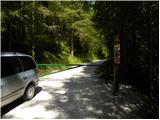 9
9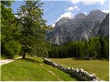 10
10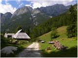 11
11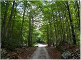 12
12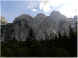 13
13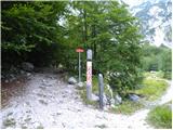 14
14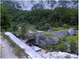 15
15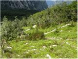 16
16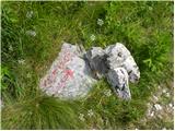 17
17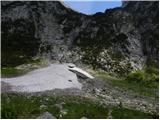 18
18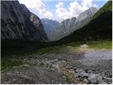 19
19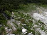 20
20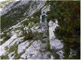 21
21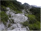 22
22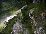 23
23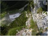 24
24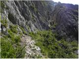 25
25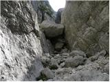 26
26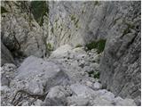 27
27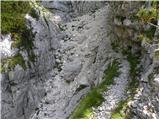 28
28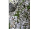 29
29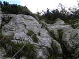 30
30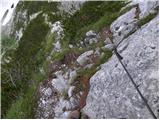 31
31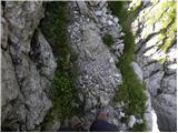 32
32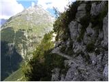 33
33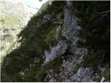 34
34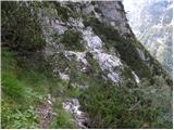 35
35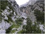 36
36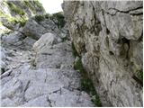 37
37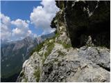 38
38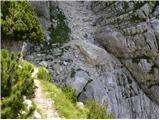 39
39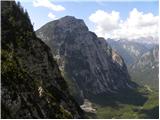 40
40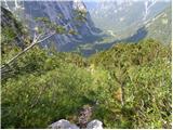 41
41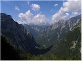 42
42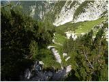 43
43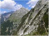 44
44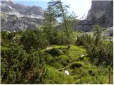 45
45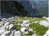 46
46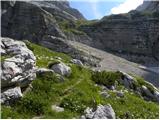 47
47 48
48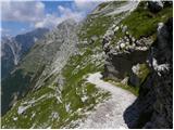 49
49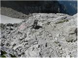 50
50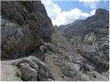 51
51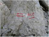 52
52 53
53 54
54 55
55 56
56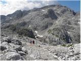 57
57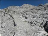 58
58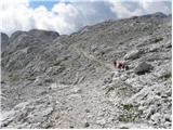 59
59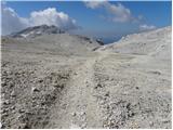 60
60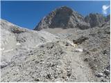 61
61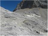 62
62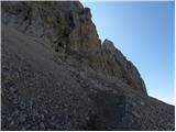 63
63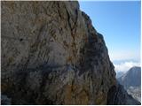 64
64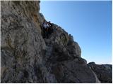 65
65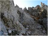 66
66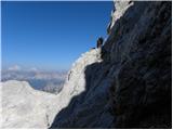 67
67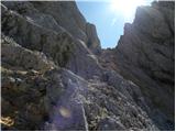 68
68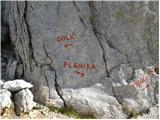 69
69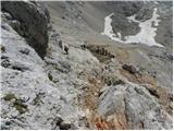 70
70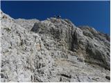 71
71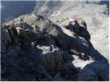 72
72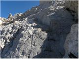 73
73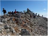 74
74
Discussion about the trip Zadnjica - Triglav (via Komar)
|
| joža x8. 08. 2013 |
The path is disproportionately harder than the "normal" from Zadnjica, checked with wife yesterday, on it there is a lot of climbing, even though on the P.z.s. map it is drawn as a non-climbing path, which is nonsense.
|
|
|
|
| Bojan28578. 08. 2013 |
Did you go via Komar? We namely didn't climb anywhere.Čavči
|
|
|
|
| merkur8. 08. 2013 |
Yes, joža x, of course the mentioned path is harder than the Zadnjica mulatiera, but there is no climbing nevertheless. On the more exposed parts it is exemplary secured - there you just hold on. It is true though, that it's wise to inquire in detail beforehand about an unknown path, for which the map (good or bad) is not enough. Regardless of everything, unknown paths are generally not chosen for descent, if an alternative exists.
Good luck!
|
|
|
|
| katty8. 08. 2013 |
Did you notice anything, how is the path towards Kanjavec further on?
|
|
|
|
| gral8. 08. 2013 |
Zadnjica via mulatiera to Dolič - nice shady path. Dolič - Kanjevec without special features and path in good condition.
|
|
|
|
| katty8. 08. 2013 |
Is there no more snow on the path over Komar, and no full snow towards Kanjavec either?
|
|
|
|
| IgorZlodej8. 08. 2013 |
Snow these days is a real godsend, I hope the summits will soon turn white, Triglav too
|
|
|
|
| katty8. 08. 2013 |
Thanks Igor for the kind reply  
|
|
|
|
| skalaš709. 08. 2013 |
Calm down a bit with the snow Igoriči, there will be enough in winter! LP
|
|
|
|
| IgorZlodej9. 08. 2013 |
@katty but it's August after all, you better hurry to Komar, because end of the month it will really snow
|
|
|
|
| miranm15. 08. 2014 |
Hello!
I'm interested in the condition of the path from Zadnjica via Komar to Dolič.
Thank you and safe steps!
|
|
|
|
| Slash1328. 07. 2017 |
I'm interested in the condition of the path from Zadnjica over Komar to Dolič. How is this path compared to Hanzova on Mojstrovka?
|
|
|
|
| simon7928. 07. 2017 |
I don't know about the current condition, I was there last September and everything was ok. Personally for me this path over Komar is much easier (very few exposed views) and also more interesting than the one to Mojstrovka. Actually it's my top 3 in the Julians, a bit mysterious, solitary, hidden, interestingly routed, pleasantly shady in the morning. Best regards and good luck!
|
|
|
|
| Slash1328. 07. 2017 |
Great, many thanks simon79!
|
|
|
|
| vladika6. 08. 2017 |
Yesterday I walked the path from Zadnjica via Komar to Dolič, then to Triglav and back to Dolič and via mulatjera back to Zadnjica.
Path description through my eyes:
From the starting point (parking is 100m from the Zadnjica sign at the 50th hairpin of the Vršič road and it's not payable) a macadam road winds which we walk for about one hour. When the road narrows into a path we arrive at the junction via mulatjera or via Komar. Note at the junction there is no sign, just a stone on which Komar and direction is written. The path via Komar is quite demanding. All protections i.e. pegs and cables are in impeccable condition and are where needed. After about three hours (I used less) the path joins the path from the mulatjera and we continue to Dolič. From Dolič to Triglav the path without special features only from the Triglavska škrbina we have protections to help. The path back to Dolič follows the same path. From Dolič via mulatjera to Zadnjica I admit the path dragged on for me. The mulatjera is partially exposed and in places precipitous. Let me add that the mulatjera is full of stones and you can twist your ankle.
The path is not for the vertiginous, also needs some fitness, but this path is very beautiful at least to me. Via Komar I think I was alone, no one anywhere.
I recommend to all who haven't been to Triglav in this direction yet to walk it once.
Also the times I used up and down. Here I emphasize that the listed times are those I used and someone will be faster, someone will take more time for individual sections.
Zadnjica - Dolič via Komar 3h 45min
Dolič - Triglav 1h 40min
Triglav - Dolič 1h 30min
Dolič - Zadnjica via mulatjera 3h
Total breaks accumulated to about 1.5h
I set off at 05:30 and back at the car at 17:00, at half past six I was already drinking coffee at Vršič .
Safe steps to all, Vlado
|
|
|
|
| VanSims15. 10. 2018 |
The path via Komar is technically demanding, but not that bad, the biggest problem might be one very steep cable somewhere in the middle and the last gully where only pegs are available.
Conditionally, the path is also quite demanding, whoever goes along it just for climbing should reckon with the last part after the end of the protections, which tires you out properly, especially the scree just before joining the mulatjera. If I had known that, I don't know if I wouldn't have gone to Doliča directly via the comfortable mulatjera.
The turn-off for Komar is somewhere where we look straight into the waterfall, about five minutes after the Dolič-Prehodavci junction, where the road through Zadnjica ends. When the path starts ascending away from the waterfall, it's already too late.
|
|
|
|
| trdi5. 08. 2019 |
Nice photos, but judging by the pictures it's the normal path along the mulatjera past the junction to the hole and not via Komar
|
|
|
|
| Jernej96822. 09. 2020 |
I hiked Komar on 5.9.2020, downhill. The fixed protections are in good condition. The markers are placed more for those going up (which is logical). Going down, caution is needed in the torrent gorge, where the tracks are less visible and some additional marker would be more than welcome.
|
|
|
|
| Lenore12. 07. 2022 11:14:20 |
There is no visible junction over Komar anywhere.
From Dolič going it is clear, written big.. but in the opposite direction from Zadnjica up there is no junction to Komar ANYWHERE.
The markings are generally quite poor there...
|
|
|
|
| miri12. 07. 2022 12:05:34 |
A little effort doesn't hurt. No need for everything to be served on a platter.
|
|
|
|
| turbo12. 07. 2022 12:11:55 |
I took this photo on Saturday, 25.6. => see the second-to-last photo in the album !!! You can see a big waterfall, to its right a chapel (white-blue). You can also see a path going through the grass towards the waterfall, then higher it crosses the gully (stream) to the right. The orientation point is the chapel, if you go in that direction, sooner or later you step onto the marked path, when you reach the wall, you are at the first fixed ropes. Usually at the junction of the Luknja-Dolič-Komar path there is a small cairn, on Saturday I forgot to check, last autumn it was there and quite large.
https://photos.google.com/share/AF1QipOipbBQgKorZbmuro5-UYA0w_7kOQfgYre2xOdQ8-bSInLhcnJb9RgSic8teKEX1A?key=bUhsYmsxZ0ZEdVNSRzdyWU91VjhyR0E1NWlhNDJn
|
|
|
|
| _sandra_12. 07. 2022 14:00:30 |
The junction is marked on a rock by the path, it says up KOMAR and an arrow is drawn.
|
|
|
|
| mirank12. 07. 2022 14:48:57 |
I've already written several times; if you take the well-trodden shortcuts, you won't see this junction. If you stick to the marked path all the time, you won't miss the junction.
|
|
|
|
| darinka417. 08. 2024 10:50:16 |
The junction for Komar is clearly visible. Checked yesterday. To me a very nice path. There are some wire ropes on the path. Yesterday I decided for ascent and descent on this path. And in the August hustle I didn't really meet anyone.
|
|
|
To post a comment you must log in:
If you do not yet have a username, you must first
register.