Zadnjica - Triglav (via Plemenice)
Starting point: Zadnjica (642 m)
| Latitude/Longitude: | 46,38240°N 13,76040°E |
| |
Route name: via Plemenice
Walking time: 7 h 20 min
Difficulty: very difficult marked way
Via ferrata: B/C
Elevation gain: 2222 m
Elevation difference along the route: 2230 m
Map: Triglav 1:25.000
Recommended equipment (summer): helmet, self belay set
Recommended equipment (winter): helmet, self belay set, ice axe, crampons
Views: 54.986
 | 5 people like this post |
Access to starting point:
From Kranjska Gora, drive over Vršič Pass towards Bovec or vice versa, but only to the 50th hairpin bend of the Vršič or Russian road (near the village of Trenta). Here we turn onto a side road, along which after a few hundred metres we park at the roadside parking lot.
Route description:
From the paid parking lot in Zadnjica valley, continue on the marked path, initially along the road towards Pogačnikov dom on Kriški podi, Razor, Stenar, Križ, Bovški Gamsovec, Luknja, Triglav, Koča na Doliču and Kanjavec. The path initially leads past a few houses or cottages and after about 15 minutes of walking brings us to a marked junction, where there used to be a free parking lot, but parking is now prohibited here.
Continue along the slightly right lower road towards Zasavska koča on Prehodavci, Koča na Doliču, Luknja and other nearby destinations (left to Pogačnikov dom on Kriški podi and other goals above Kriški podi and the lower station of the cargo cableway to Kriški podi), where the gentle road continues across scenic meadows, higher through the forest. Just before the end of the forest road at the Planja junction or before the valley head in the area called Utro, a marked path branches right towards Prehodavci.
Continue straight along the road, which soon turns into a hiking path or old military mule track, along which we mostly ascend moderately on increasingly steeper slopes. Still in the forest, a climbing path branches right via Komar, but we continue along the mule track, which ascends in numerous hairpins, and due to the steep slopes above us, parts of the path are exposed to falling rocks.
The fairly scenic path brings us to an altitude of about 1500 metres to the next junction, where the path to Koča na Doliču branches right, and we continue straight towards Luknja, Pogačnikov dom on Kriški podi and Triglav via Plemenice.
We continue ascending along the mule track, which leads above Koriti, and we follow the path, which is still partially exposed to falling rocks, to the marked junction at Luknja, where we join the path from the Vrata valley starting point and from where a nice view opens to the other side.
From Luknja, head right towards Triglav (left to Bovški Gamsovec and Pogačnikov dom, straight down to Aljažev dom in Vrata).
The path then becomes very demanding and starts with an almost vertical ascent secured by a chain. After climbing the initial wall, the path levels slightly, but this does not mean the end of difficulties. From here on, there are almost no safety features, and we occasionally walk on a trail above a deep abyss. In wet conditions, high risk of slipping! The difficulties gradually ease, and the path turns slightly left, bringing us to a ridge from where a view opens to the east. We continue along the scenic ridge, and the path soon becomes somewhat more demanding again. With the help of a chain and numerous pegs, we ascend steeply several times, followed by a short steep descent. Here, a view opens to the left towards the famous Sfinga (the steepest Triglav pillar).
The path then becomes less steep and leads across scree terrain. The trail is somewhat less visible here, running left of Glava v Zaplanji and Triglavska vojašnica Viktorja Emanuela III. (formerly incorrectly named Morbegna), which we see ahead. Even in summer, there may be some snow patches on this section, but they are not steep, so crampons are usually not needed.
The path then brings us to a junction on the Western Triglav Plateau. Continue left upwards towards Triglav (right to Dolič, sharply right to Triglavska vojašnica Viktorja Emanuela III.) across scree to the entry into the next climbing section. This section is significantly easier than the one via Plemenice, so it won't cause us major problems (only crowds can be considerable). The path continues transversely upwards with numerous safety features and brings us below the Triglavska or Bovška škrbina. We then ascend to the škrbina, arriving at a junction. Continue left upwards (straight down to Planika) along a steep but well-secured path. After a few ascents, the steepness eases, and only a few minutes of ascent remain along the summit slope of Triglav.
Starting point - Clearing 0:15, Clearing - Utro 1:00, Utro - Komar junction 0:15, Komar junction - Below Skok 1:10, Below Skok - Luknja 0:45, Luknja - Plemenice 2:00, Plemenice - Zaplanja junction 0:45, Zaplanja junction - Triglavska škrbina 0:35, Triglavska škrbina - Triglav 0:35.

Along the route: Na placu (714m), Utro (984m), Odcep za Komar (1058m), Pod Skokom (1494m),
Luknja (1766m), Plemenice (2372m), Zaplanja (2428m), Triglavska škrbina (2655m)
Photos:
 1
1 2
2 3
3 4
4 5
5 6
6 7
7 8
8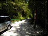 9
9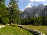 10
10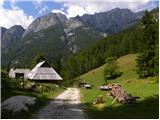 11
11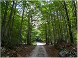 12
12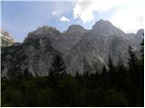 13
13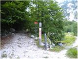 14
14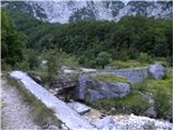 15
15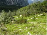 16
16 17
17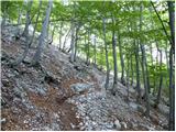 18
18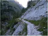 19
19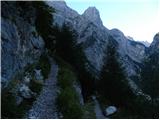 20
20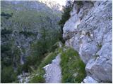 21
21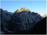 22
22 23
23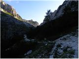 24
24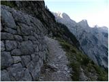 25
25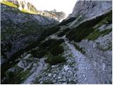 26
26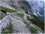 27
27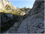 28
28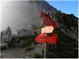 29
29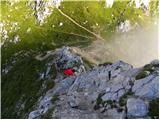 30
30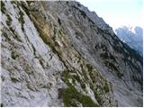 31
31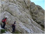 32
32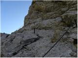 33
33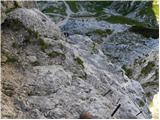 34
34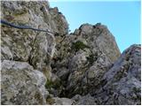 35
35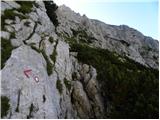 36
36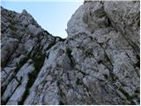 37
37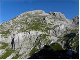 38
38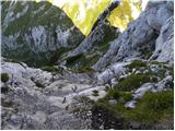 39
39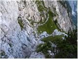 40
40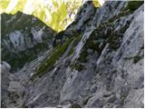 41
41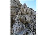 42
42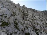 43
43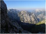 44
44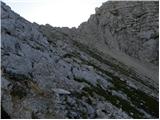 45
45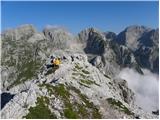 46
46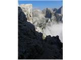 47
47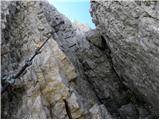 48
48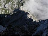 49
49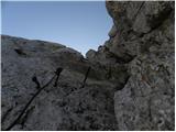 50
50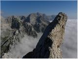 51
51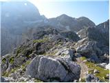 52
52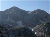 53
53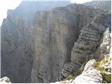 54
54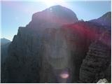 55
55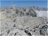 56
56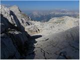 57
57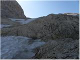 58
58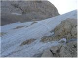 59
59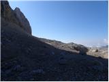 60
60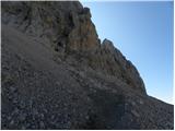 61
61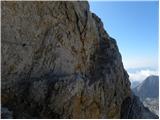 62
62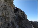 63
63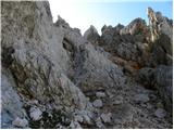 64
64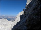 65
65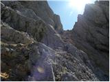 66
66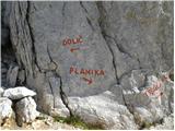 67
67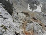 68
68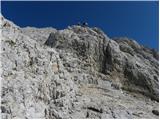 69
69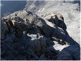 70
70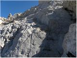 71
71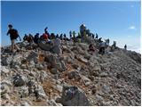 72
72
Discussion about the trip Zadnjica - Triglav (via Plemenice)
|
| Gost27. 09. 2006 |
 The path is very nice, but strenuous and a bit adrenaline-pumping. I think that going up, the self-belaying set comes into play only a little, unless you plan to return the same way. The path is very nice, but strenuous and a bit adrenaline-pumping. I think that going up, the self-belaying set comes into play only a little, unless you plan to return the same way.
Best regards.
|
|
|
|
| Gost13. 09. 2007 |
I listen to and read comments from hikers who have walked the path. Is it really not possible to better secure the exposed part of the path?! It's a shame that even hikers who don't want to expose themselves like that can't experience Triglav via Plemenice and see the Sphinx.
Please pass it on and consider.
Mountain greetings from Maribor
|
|
|
|
| Gost14. 09. 2007 |
They say that everything is possible if you want it. But I think Bembergova should remain as it is. Let it remain for the bravest. Not all mountain paths are intended for everyone: you have to find paths suitable for yourself or your abilities. After all, in life we can't have everything. But I wonder: is my ascent less valuable if I reach Triglav via Dolič or Planika? Nejc wrote: "He who seeks the goal will remain empty when he reaches it. He who finds the path will always carry the goal within himself." The more beautiful paths and let's be proud of the goals we carry within ourselves. Good luck and stay safe!
|
|
|
|
| Gost17. 11. 2007 |
What are you loading now, choose a tour appropriate to your abilities. Lp Franc
|
|
|
|
| Gost21. 11. 2007 |
I also think that the path over Plemenice is appropriately secured.
The part of the path where Sten (with Sfinga in the foreground) attracts our eyes can also be viewed by descending from Morbegna (via mulatjera from Dolič) along easy terrain following the markings and returning the same way. It's not necessary that our goal is always the summit, right?!
There is also a lesser-known, partially unmarked option, where from the mulatjera Zadnjica-Dolič we turn above the remains of military buildings and look for the remains of the old Kugy path to Triglav. It joins the marked path over Plemenice exactly where a beautiful view of Sfinga opens up ... although the path is not very demanding and is even secured with old cables in one place, it still requires a mountaineer who can follow it and is not entirely dependent on markings (which are still visible in places).
Good luck!
|
|
|
|
| Gost21. 11. 2007 |
I'm really glad for that last information. This year I read about this path and was interested in how much it is still preserved. I'll try to find it in the summer! lp, špela
|
|
|
|
| peter226. 07. 2008 |
We hiked the trail from Zadnjica through Plemenice yesterday. It is really wonderful and recommended, of course for an experienced mountaineer. Some photos are on www.petersfoto.si
|
|
|
|
| ladog5. 03. 2010 |
Congratulations to everyone who made it through Plemenice!
|
|
|
|
| Keco10. 08. 2010 |
One-day tour through Plemenice and back to Dolič in Zadnjica. Tiringggg! Nice tour if you like first pitches of free climbing!
And surprisingly no crowds!!!
|
|
|
|
| kakav30. 08. 2010 |
Last week I also went on a one-day trip from Zadnjica via Plemenice and back via Dolič. Really wonderful climbing through Plemenice. Crossing from the Trenta side to the Vrat side and back somewhere in the middle via the exposed passage is really top-notch. (short but sweet).
But I convinced myself with my own eyes that the stories about ripped-off Czechs are not bullshit. First, at the start of the path from Dolič to Triglav, I met a young Czech girl who had rushed up the scree in sandals only. I hope they were at least Tewa . An even bigger joke was when I met a young Czech with a small doggy on top of Triglav (surprisingly the whole path was without crowds even though it was a sunny Sunday). They said it was a Tibetan Terrier and that she's used to climbing, that they came via Plemenice and she did great, where it didn't go, they carried her on their shoulder or put her in the backpack. Really models. And she's only 9 months old - unfortunately no one told them that dogs that are too young go to the mountains can have hip problems when they grow up - I hope it doesn't happen to this cute little doggy. Anyway, Czechs are really models and it makes you laugh, but it can be all the more sad if something goes wrong. You can tell their highest hill is a little over 1500m.
|
|
|
|
| soncyka14. 09. 2010 |
The path through Plemenice is excellent, in places really adrenaline-pumping, but it's true that it's not intended for inexperienced hikers or those not enthusiastic about somewhat more dangerous sections. I did the path myself in one day and also think it should remain as it is, because not everyone can have everything. The Sphinx is also nicely visible on the path through Vrata.
|
|
|
|
| andraz8525. 06. 2013 |
has anyone maybe recently traversed this path? especially interested in snow conditions... thanks for any response...
best, andraž
|
|
|
|
| pipi1005. 07. 2013 |
I'm also interested in the conditions on the path, if anyone has any information.
|
|
|
|
| redbull6. 07. 2013 |
There's still snow in the notch, but I hardly believe it elsewhere
lp
|
|
|
|
| darinka421. 07. 2021 15:32:25 |
Yesterday hiked the trail from Zadnjica to Luknja. Via Plemenice and Triglavske pode to the summit. Bovška škrbina is snow-free. Plemenice too. Only on the podih is there still snow. Which poses no problems. I had an ice axe but didn't need it. Met very few hikers. No one via Plemenice. No crowds at the summit either.
|
|
|
|
| franc.rozman@adventure.si22. 07. 2021 16:42:49 |
Darinka4, congratulations on the completed tour.
I'm interested if all pegs and cables in the lower part are usable and in the wall?
Thanks.
best regards, Franc
|
|
|
|
| darinka422. 07. 2021 16:54:17 |
Thanks. All pegs and cables over Plemenice are in place. I think they renovated them last year. In one part somewhere in the middle they added a ledge and pegs where there weren't before. The climbing path and those parts without climbing are all fine for now.
|
|
|
|
| kroker112. 08. 2024 11:50:45 |
I read the news that a foreign citizen had a fatal accident on this path. Has anyone been on the path recently and is it damaged to the extent that it's so risky?
|
|
|
|
| Janez Seliškar12. 08. 2024 12:41:43 |
Climbers descend the path after climbing in the Face and it's normally passable.
|
|
|
|
| mirank12. 08. 2024 12:57:33 |
Our group went there on Saturday and there was nothing wrong with the path.
|
|
|
To post a comment you must log in:
If you do not yet have a username, you must first
register.