Zadnjica - Zadnjiški Ozebnik
Starting point: Zadnjica (650 m)
| Latitude/Longitude: | 46,38240°N 13,76040°E |
| |
Walking time: 4 h 15 min
Difficulty: easy unmarked way
Elevation gain: 1434 m
Elevation difference along the route: 1450 m
Map: TNP 1:50.000
Recommended equipment (summer):
Recommended equipment (winter): ice axe, crampons
Views: 33.834
 | 5 people like this post |
Access to starting point:
From Kranjska Gora, drive over Vršič Pass towards Bovec or vice versa, but only to the 50th hairpin turn of the Vršič or Russian Road (near the village of Trenta). Here, turn onto the side road, along which we park after a few hundred meters at the parking lot by the road.
Route description:
From the parking lot, continue along the road, which takes us past a few houses (mostly weekend cottages) in about 15 minutes to the point where the road splits into two parts (there used to be a parking lot at the intersection, but parking is now prohibited).
Continue along the lower right road (the upper road leads to the cable car to Pogačnikov dom) towards Dolič, Luknja and Prehodavci. Follow the initially gentle road, which leads through scenic meadows and higher through the forest, almost to its end, or more precisely to the marked junction where the marked footpath to Prehodavci branches off to the right (about 1 hour to here).
From the junction at the area called Utro, continue right (straight to Luknja, Triglav and Dolič), where we first cross partly overgrown scree and a few torrents. After a few minutes of crossing with some short ascents and descents, we reach the beginning of Zadnjiški dol. Here the path begins to ascend moderately on the right side of the valley. Higher up, the path turns a bit more to the right, temporarily taking us into the forest, then returning to a more rocky terrain. The path further leads to a spring, next to which there is a small bench where we can rest. Continuing, the path ascends moderately to steeply for a while and gradually transitions to the scree slopes below Zadnjiški Ozebnik. With a view of the nearby walls of surrounding peaks, we then ascend to the saddle Čez Dol, where the path levels out and splits into two parts.
The left path leads towards Prehodavci, the lower right one towards Trenta. Choose the lower right path, which we follow for only a few dozen steps, or to the nearby cairn.
At the cairn, leave the marked path and head right onto an initially barely visible path that crosses the overgrown grassy saddle Čez Dol. On the northern side of the saddle Čez Dol, we reach the southern slopes of Zadnjiški Ozebnik or initially still the slopes of Veliki Konj. The initially barely visible path then leads us across grassy slopes overgrown with bands of dwarf pines. Higher up, the path takes us into a short indistinct valley, from which with the help of a few cairns we reach the ridge of Zadnjiški Ozebnik. Here continue right and proceed along the very scenic ridge. The summit, which we can already see ahead, is reached after about five minutes of further walking.
Zadnjica - Čez Dol 3:00, Čez Dol - Zadnjiški Ozebnik 1:15.

Along the route: Čez Dol (1632m)
Photos:
 1
1 2
2 3
3 4
4 5
5 6
6 7
7 8
8 9
9 10
10 11
11 12
12 13
13 14
14 15
15 16
16 17
17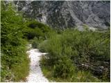 18
18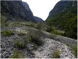 19
19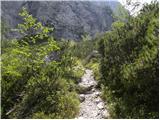 20
20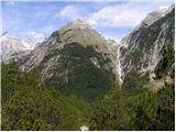 21
21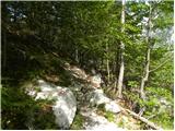 22
22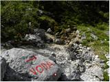 23
23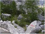 24
24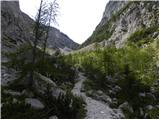 25
25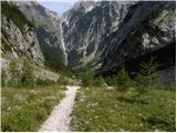 26
26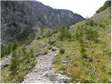 27
27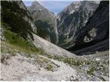 28
28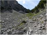 29
29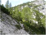 30
30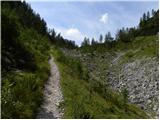 31
31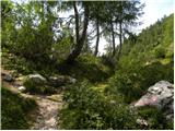 32
32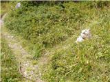 33
33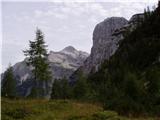 34
34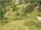 35
35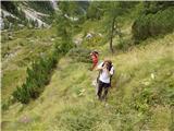 36
36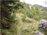 37
37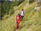 38
38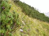 39
39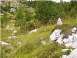 40
40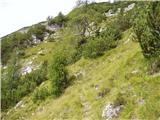 41
41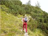 42
42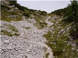 43
43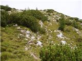 44
44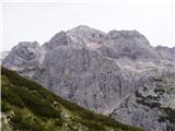 45
45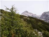 46
46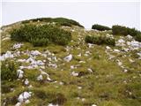 47
47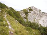 48
48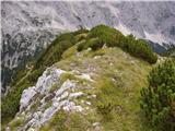 49
49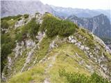 50
50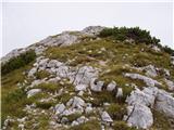 51
51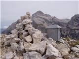 52
52
Discussion about the trip Zadnjica - Zadnjiški Ozebnik
|
| Gost22. 09. 2007 |
here I found loads of blackberries, it even smelled like chocolate. Marko
|
|
|
|
| klavdipo22. 10. 2009 |
Is there also a summit logbook and stamp in the summit box visible in one of the pictures?
|
|
|
|
| _Abuh_23. 10. 2009 |
I'll check it out on Sunday. 
|
|
|
|
| vagabund11. 06. 2010 |
On Wednesday 9.6 I ascended from Zadnjica through Zadnjiški dol to the saddle čez dol and from there to Zadnjiški Ozebnik. To the saddle čez dol there's still some snow patches which don't pose serious obstacles, further the path to the top of Zadnjiški Ozebnik is completely dry. The path from the saddle onwards is not marked but fully traceable and at every bend cairns show the right path. In the box there is a notebook and a nice hand-made logbook. Nice tour, I recommend. After descending to the saddle čez Dol I went up to Prehodavci and bivouacked there alone in the winter room. Yesterday 10.06. I crossed the ridge to Veliki špič or Lepe špice.
|
|
|
|
| spotonbody24. 06. 2010 |
Yippee, tomorrow on this nice hike! 
|
|
|
|
| spotonbody1. 07. 2010 |
Holiday Friday was just right for visiting the long-awaited less crowded Zadnjiški Ozebnik. Beautiful summit with wonderful views towards Kriške pode, Triglav, Prehodavci and more.. The path is now completely dry, easier, suitable also for children. A little nuisance on the path is caused perhaps only by the dwarf pines that have overgrown the path in places, so you have to pay a bit more attention a few times not to stray from the path, otherwise there are plenty of 'cairns' to kindly show the way. I also placed two of them for you!  Great trip, I recommend to everyone! Great trip, I recommend to everyone!
PS: When do we then organize a small session of 'clearing' the dwarf pines on the path?
Praise also goes to the person(s) who take(s) care of the summit logbox with the nice book of impressions and memories!
|
|
|
|
| dj122. 07. 2010 |
Can you attach some more picture under the description so we can see how nice it was... LP LP
|
|
|
|
| IgorZlodej2. 07. 2010 |
Pictures are under "Forum-conditions", can't upload them under descriptions, otherwise I don't know how sensible it is to post the same thing twice.
|
|
|
|
| dj122. 07. 2010 |
Thanks Igor, I found and viewed them, now back to work....Really nice tour to Zadnjiški Ozebnik. Best regards
|
|
|
|
| IgorZlodej2. 07. 2010 |
The girl was also cute when I met her down in Zadnjica.
|
|
|
|
| grega_p26. 07. 2010 |
I recommend a circular path namely descent through Trebiški dol, I went in the opposite direction and found that ascent via Zadnjica is easier than descent. Lots of forest delights at this time - strawberries, blueberries, raspberries. Be careful also of adders - one bit me properly just before the summit!
Otherwise as already said, a very beautiful summit with exceptional views: Bavški Grintavec, Briceljk, Pelc nad Klonicami, Jalovec, Mangart, Mojstrovke, Trentski Pelc, Prisojnik, Razor, Goličica, Pihavec, Luknja (through which Dovje is visible and I think Klek - Karavanke), Triglav, Kanjavec, Špičje etc...
|
|
|
|
| čemaž21. 07. 2011 |
Went on Saturday on a circular tour from Zadnjica to the saddle and summit, then looked for passages on the other side and returned to the marked path in the village Na logu. Whoever likes solitude and nice views should visit it.
|
|
|
|
| damijanp21. 08. 2014 |
Last Saturday we did a circular route - Zadnjica, Zadnjiški Ozebnik, Trenta. Unfortunately no views because the summit was in fog, but a multitude of flowers along the path made up for it. Plenty of junipers too, which sometimes don't let you through
Photos at:
Zadnjiški Ozebnik
|
|
|
|
| masker29. 09. 2014 |
Yesterday I took advantage of the nice sunny weather and climbed this hill with friends. Since it was neither too hot nor too cold, it was really a pleasure to hike up the mountain while enjoying the panoramic views. After a good four hours of ascent, the summit was reached, offering a truly magnificent view. We enjoyed the really beautiful view for a good hour. I also think yesterday was the most beautiful day of all I've spent this summer in our Slovenian mountains.
|
|
|
|
| ajo6230. 09. 2014 |
You're right masker, on Sunday 28 Sept. it was probably the nicest day of this season, and we also used it to visit this extraordinarily scenic Trenta two-thousander! The shepherd's path is very logically laid out, there are many cairns along the path so it's impossible to miss the direction. The summit deserves more visits, there were at least 7 of us on top on Sunday, which is already something.. Nice greetings to all lovers of mysterious corners of our Julian Alps!
|
|
|
|
| darinka420. 08. 2016 |
Has anyone been to Zadnjiški Ozebnik recently? I'm wondering if the path is still traceable?
|
|
|
|
| lynx20. 08. 2016 |
I haven't been, but even at New Year it was clearly visible.
|
|
|
|
| Viper20. 08. 2016 |
The path is clearly visible
|
|
|
|
| Zava14. 05. 2019 |
up there it's great:
Nice video on YouTube from Zadnjiški Ozebnik - I'm wondering if I can post it in my hiking announcement for it?
|
|
|
|
| djimuzl14. 05. 2019 |
Zava, write to him on ZS.
|
|
|
|
| djimuzl14. 05. 2019 |
Or rather - contact the person who posted this video on YouTube, it's not necessarily the same person.
In principle, public posts can be shared - with precise attribution of authorship, of course. However, it's always better to get the author's permission.
|
|
|
|
| PUHIPUHI24. 08. 2019 |
Really wonderful viewpoint! Right after the junction to the unmarked path, lots of sweet blueberries. The path to the summit is nicely traceable.
|
|
|
|
| Darxta8. 09. 2025 14:38:18 |
The day before yesterday on this path to the summit. Up to the saddle Čez Dol the path is well marked, beyond the saddle it is easily followed. At the summit there is a log box, but it is empty.
On a nice day the views are phenomenal!
|
|
|
To post a comment you must log in:
If you do not yet have a username, you must first
register.