Zadnjica - Zasavska koča na Prehodavcih
Starting point: Zadnjica (642 m)
| Latitude/Longitude: | 46,38240°N 13,76040°E |
| |
Walking time: 4 h 15 min
Difficulty: easy marked way
Elevation gain: 1429 m
Elevation difference along the route: 1430 m
Map: Triglav 1:25.000
Recommended equipment (summer):
Recommended equipment (winter): ice axe, crampons
Views: 110.959
 | 7 people like this post |
Access to starting point:
From Kranjska Gora via Vršič Pass towards Bovec or vice versa, but only to the 50th hairpin turn of the Vršič or Russian road (near the village of Trenta). Here we turn onto a side road, along which after a few hundred metres we park at the parking lot by the road.
Route description:
From the parking lot, we continue along the road, which takes us past a few houses (mostly weekend cottages) in about 15 minutes to the point where the road splits into two parts (there used to be a parking lot at the intersection, but parking is now prohibited).
We continue along the lower right road (the upper road leads to the freight cableway to Pogačnikov dom) in the direction of Dolič, Luknja and Prehodavci. We follow the initially gentle road, which leads through scenic meadows, higher up through the forest, almost to its end, or more precisely to the marked junction where a marked footpath branches off to the right towards Prehodavci (about 1 hour to here).
From the junction in the area called Utro we continue right (straight Luknja, Triglav and Dolič), first crossing partly overgrown scree slopes and a few torrents. After a few minutes of traversing with some short ascents and descents we reach the beginning of Zadnjiški dol. Here the path begins to ascend moderately on the right side of the valley. Higher up the path turns a bit more to the right, briefly taking us into the forest, then returning to a more rocky terrain. The path further leads to a spring, next to which there is a small bench where we can rest. Continuing, the path ascends moderately to steeply for some time and gradually transitions onto the scree under Zadnjiški Ozebník. With views of the nearby cliffs of surrounding peaks, we then ascend to the saddle Čez Dol, where the path levels out and splits into two parts.
At the mentioned junction we continue left towards Zasavska koča na Prehodavcih (straight Trenta) and then ascend along the path which continues over a fairly steep and partly exposed slope. We follow this somewhat narrower path to the nearby junction where we join the mule track from Trenta.
(If we find the short somewhat exposed section too dangerous, we can reach the mentioned junction also via a slightly longer path. In this case at the previous junction continue straight towards Trenta and then a bit further left towards Prehodavci).
At the mentioned junction continue straight and then ascend along the wide mule track, which crosses steep and precipitous slopes. During the ascent over the precipitous slope we will notice a small "chapel" (statue of Mary with Jesus) on the left side.
Further on, the slope along which the path runs becomes less steep and more scenic. Higher up the well-preserved mule track leads over a slightly less steep slope of Zelene grive, above which the slope becomes steep again. A few short steep sections follow, then the path and the slope level out. Somewhat above the indistinct break we reach a marked junction, where we continue left (right Lepo oz. Veliko špičje - Stanko Kos path, straight Koča pri Triglavskih jezerih) towards the nearby Zasavska koča na Prehodavcih. The path further leads along a wide and scenic ridge, which past the winter bivouac takes us in a few minutes to Zasavska koča na Prehodavcih.
Izhodišče - Na placu 0:15, Na placu - Utro 1:00, Utro - Čez Dol 1:45, Čez Dol - Plate 1:10, Plate - Zasavska koča 0:05.

Along the route: Na placu (714m), Utro (984m), Izvir v Zadnjiškem dolu (1237m), Čez Dol (1632m), Plate (2056m)
Photos:
 1
1 2
2 3
3 4
4 5
5 6
6 7
7 8
8 9
9 10
10 11
11 12
12 13
13 14
14 15
15 16
16 17
17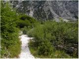 18
18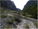 19
19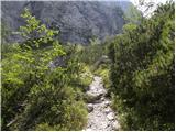 20
20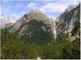 21
21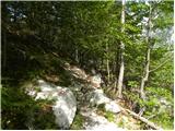 22
22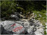 23
23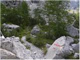 24
24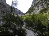 25
25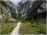 26
26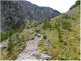 27
27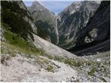 28
28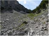 29
29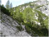 30
30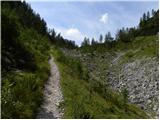 31
31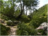 32
32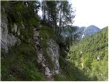 33
33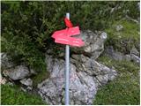 34
34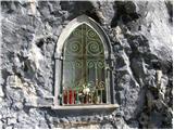 35
35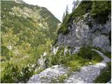 36
36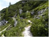 37
37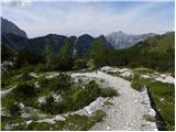 38
38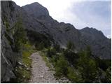 39
39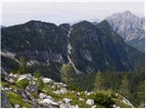 40
40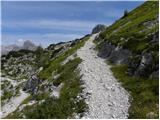 41
41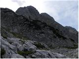 42
42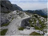 43
43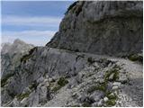 44
44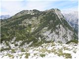 45
45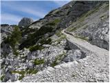 46
46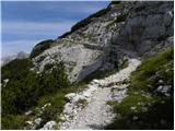 47
47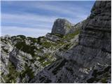 48
48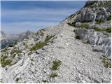 49
49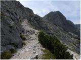 50
50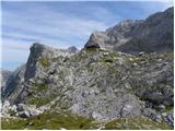 51
51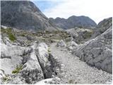 52
52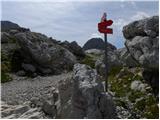 53
53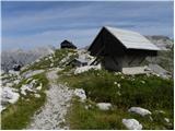 54
54 55
55 56
56 57
57
Discussion about the trip Zadnjica - Zasavska koča na Prehodavcih
Show older messages
|
| Gost17. 07. 2007 |
How much of this path is in the shade?
|
|
|
|
| Joža17. 07. 2007 |
Yesterday I went down from Prehodavci in the afternoon and I'd say a good third. LP.
|
|
|
|
| Gost24. 07. 2007 |
I returned from Prehodavci pleasantly surprised and happy that the younger generation also knows how to care well for hikers who visit Zasavska koča na Prehodavcih. The hut is exemplarily maintained, the staff very, very friendly... In the conditions prevailing in the high mountains, hats off. They deserve a straight ten. So once again, friendly greetings up to the hut to those guys and girls.
Good luck and stay safe in the mountains!
|
|
|
|
| Gost24. 07. 2007 |
Very likely, the hut at Prehodavci also has the same team of young people in charge this year as two years ago when my husband and I were there. I haven't actually encountered such young staff anywhere else, nor such pleasant ones very often! I join the above opinion!
|
|
|
|
| Gost26. 07. 2007 |
SUPER STAFF, YOUNG PEOPLE SHOULD TAKE OVER IN OTHER HUTS TOO (DOLIČ..)
|
|
|
|
| mkonci21. 07. 2009 |
Some time has passed since the previous post, but I can say that the team at the hut is very young!
The trail is ok, only early in the morning when it is still cold caution is needed when crossing 3 snowfields (there is quite a lot of snow). The pleasures on the descent are fantastic, there is no scree but a snowfield and you can "ski" for several meters...
|
|
|
|
| grahlck3. 08. 2009 |
Has anyone hiked the Kanjevičeve police? What's the path like? Lots of snowfields?
|
|
|
|
| pipe5. 09. 2009 |
Hi
I'm really wondering who set 3 1/2 hours for
this path. We're not all young goats. The staff at the hut is great.
|
|
|
|
| MiR5. 09. 2009 |
I often ask the same. The time on signs and in guidebooks is somehow like this through life's stages:
- when you're young, you shorten it
- then comes the period when it's just right
- when your EMŠO becomes indecently serious, you add an hour or even more to that time. Otherwise, time isn't important, the main thing is to have your path, then the goal comes too. And what is an extra hour in the mountains compared to eternity.
Good luck to all!
|
|
|
|
| petruša12. 03. 2010 |
I'm interested in the path from Zasavska koča towards Koča pri Triglavskih jezerih. How long is the path, and is it marked? If anyone has already walked this path, please describe it a bit, as we would like to do it in summer. Thanks in advance. lp
|
|
|
|
| spotonbody24. 06. 2010 |
petruša: at the top by Zasavka hut, where I was last week, there are signs saying 2'15 hours more to the hut at Triglav Lakes. The path is marked. lp
|
|
|
|
| spotonbody24. 06. 2010 |
On this path from Zadnjica through Dol on 13.06. there were still some small snow patches but nothing dangerous, all passable without crampons to the top of Zasavska koča. Some chamois also kept company
|
|
|
|
| mt22. 08. 2010 |
From 21.8. to 22.8.2010 I was a guest at Zasavska koča. I must praise the guys (caretakers) who despite the masses managed things well. Jota and ričet were good. Sleep incomplete due to crowding and (snoring) but not because of the friendly staff. Already because of the weather we (team of 15) were in good spirits. Definitely good.
|
|
|
|
| bambroz24. 08. 2010 |
I also slept in the hut from 21st to 22nd.
We were returning from Triglav. I think the staff could have fitted all people into the hut so they wouldn't be standing outside, or could have started preparations for sleeping earlier than at 22:00
|
|
|
|
| medicinka24. 08. 2010 |
Many of us slept at Prehodavci. The guys were friendly, quick and obliging. Despite the long queue you got things as if by magic.
|
|
|
|
| Janiel7422. 09. 2011 |
Please, some advice or time help
One variant is to go to Triglav tomorrow. Namely: Zadnjica - Zasavska koča na Prehodavcih - Dolič - Triglav and back down to Dolič and then via Komarča to Zadnjica. If I start at 4am from Zadnjica... Would I make it back before dark? How long time-wise from Dolič via Komarča to Zadnjica downhill? Maybe someone knows? Thanks
|
|
|
|
| katty22. 09. 2011 |
Wow Jani, you're good. Great tour you've chosen, a similar one is still waiting for me. Probably next year. The path from Dolič to Triglav is apparently really pleasant, and it seems not so crowded. So short and to the point, just enjoy and let me know how it was. Best regards
|
|
|
|
| Janiel7422. 09. 2011 |
Not yet chosen That's why I want some comment and advice, if this works out for me. Are the markings good at the beginning of the trail from Zadnjica, so I don't get lost somewhere in the dark..because I'm going alone and don't know the path
|
|
|
|
| petruša22. 09. 2011 |
Hello, in August we went from Zadnjica towards Luknja. A man and woman went behind us to Prehodavci. Good that we knew the path where it branches off to Prehodavci, because there is no sign anymore. Since we were just asking at this junction and talking to them, they thought to go straight, so we told them. Before you reach the stream, the path branches off to the right to Prehodavci. Good luck
|
|
|
|
| petruša22. 09. 2011 |
Remember the fourth picture, there's no sign there anymore. lp
|
|
|
|
| robi1422. 09. 2011 |
@petruša: The red sign at the junction was still there a month ago...
@Janiel74: You won't miss the path with a headlamp, because it's well marked..
Enjoy
|
|
|
|
| otiv22. 09. 2011 |
A one-day visit to Triglav does depend on fitness, if there's no problem here, there shouldn't be on the tour either.
Good luck and nice views from our Father.
|
|
|
|
| Janiel7422. 09. 2011 |
Thanks I don't know yet Maybe from Savica - Komarča - Koča pri Triglavskih jezerih - Prehodavci - Kanjavec - Dolič - and back..)) depending on when I start the hike
|
|
|
|
| maucec4022. 09. 2011 |
Janiel, just so you know, the path down through Komar is quite demanding, and you'll be chasing the day too... Up it's great, down I don't recommend it. Time-wise it's the same if you go down nicely along the path towards Luknja and Zadnjica. Good luck and lots of enjoyment!
|
|
|
|
| katty22. 09. 2011 |
Yes, I agree with the above comment too. Komarča downhill is quite strenuous , on some sections you have to be especially careful. I think the path from Zadnjica to Prehodavci, Kanjavec to Dolič would be better. You'll walk some mule tracks that give these ends a special charm. , on some sections you have to be especially careful. I think the path from Zadnjica to Prehodavci, Kanjavec to Dolič would be better. You'll walk some mule tracks that give these ends a special charm.
If you want to go via Komarča to Sedmerih and Prehodavci etc., you'd really have to start at 4. Because I'm afraid darkness would catch you before . .
Let us know your decision.
lP
|
|
|
|
| ivona22. 09. 2011 |
Petruša is right. There is no sign that says Prehodavci.
|
|
|
|
| IgorZlodej22. 09. 2011 |
The guy doesn't even know where he would go, and you give so many tips as if you walk around there every week.
|
|
|
|
| tisa22. 09. 2011 |
Hi Igor!
The question was more general and so were our answers.
Good luck!
|
|
|
|
| IgorZlodej22. 09. 2011 |
With such a set goal, there are no general questions, you need to know the path sections well, otherwise better not to think about it.
|
|
|
|
| maucec4022. 09. 2011 |
That's why it's good to sometimes discourage something. For example, down through Komar (not the intended Komarča Katty). Maybe Janiel74 will think better about his decision with such advice. Good evening everyone!
|
|
|
|
| kungočan22. 09. 2011 |
We went to Luknja on 18.8. and the sign for Prehodavci was really there. LP
|
|
|
|
| katty22. 09. 2011 |
maucec49 thanks for the info. And for the others, so I know why I'm going. Otherwise yes, the purpose of the forum is to advise and help others with our experiences who don't know what they're getting into.
|
|
|
|
| Janiel7424. 09. 2011 |
Well in the end I went this:
Koča pri Savici - Komarča - Koča pri 7J - Zasavska koča pri Prehodavcih - back to 7J - Komna - Savica.... first time I met chamois Fantastic but also veeeeery long path, especially the GorDol path 7J-Komna dragged on
|
|
|
|
| falcon27. 08. 2014 |
Does anyone have info on the current path condition?
|
|
|
|
| fantazija11. 07. 2019 |
Hi,
could someone please write if from Zasavska koča to the hut at Triglav Lakes there is any exposed terrain?
thanks and best regards
|
|
|
|
| margu5011. 07. 2019 |
I would first recommend the path from Trenta to Prehodavci to you, much nicer than from Zadnjica, time-wise the same. To the hut at Sedmerih there is nothing exposed.
|
|
|
|
| bbugari111. 07. 2019 |
There is more exposed terrain on all approach paths to Prehodavci.
|
|
|
|
| B211. 07. 2019 |
The path from Log in Trenta is beautiful and follows an old mulatere, which gently brings us to Prehodavci. The path from Zadnjica also follows some sections of the former (now destroyed) mulatere, but it is more monotonous and strenuous. All the time we see the saddle above planina Dol in front of us, where the paths from Zadnjica and Trenta meet, but getting there involves quite some "torment". Paths laid out on gentle, fairly wide and trodden former (Italian) mulateres I wouldn't count as exposed... The accesses to Prehodavci from the hut at 7J and Dolič are also not exposed. Just happily on the way to these beautiful corners of the Julian Alps!
|
|
|
|
| bbugari111. 07. 2019 |
The feeling of exposure is quite subjective. For some, even the path above Ledvica is exposed.
And even more the mulatere at Dolič or Hribarice. I don't count the approach to Prehodavci from 7 lakes, because the fantasy obviously plans a descent from Prehodavci to 7 lakes.
|
|
|
|
| fantazija11. 07. 2019 |
Yes, descent from Prehodavci to 7J.
Really thanks for the vivid description of the path. We would have a friend with us who is a bit more sensitive to exposed terrain - but no panic.
Thanks marqu50 for the tip.
|
|
|
|
| miratan31. 03. 2021 |
On Sunday we would go from Zadnjica to Zasavska koča na Prehodavcih. Has anyone gone in this direction in the last few days? Who knows what the conditions are like?
|
|
|
|
| Jernej96823. 04. 2021 22:11:53 |
Miratan, have you perhaps done this tour? What were the conditions?
|
|
|
|
| Rajskioskar21. 06. 2022 11:41:15 |
Hello,
given the high temperatures I assume there are currently no snow obstacles on the path. Correct? Thanks for the info.
|
|
|
|
| pikica929. 07. 2023 08:29:37 |
Parking paid 5/day. The trail is fine but I walked longer than stated, I'm slow...
|
|
|
|
| Tomaž0015. 07. 2024 16:07:19 |
Is this path normally passable, or is there still some snow?
|
|
|
|
| anazala28. 06. 2025 11:34:18 |
Is it possible to go up with a dog? It's dangerous.
|
|
|
|
| miri28. 06. 2025 11:55:10 |
But aren't you worried about yourself?
|
|
|
|
| ppegan28. 06. 2025 12:20:14 |
If the dog is used to such high-mountain paths, this will be a piece of cake for it Only it can get hot, especially on descent, so start early in the morning and take enough water
|
|
|
To post a comment you must log in:
If you do not yet have a username, you must first
register.