Zadnjica - Zasavska koča na Prehodavcih (via Mira Marko Debelak)
Starting point: Zadnjica (642 m)
| Latitude/Longitude: | 46,38240°N 13,76040°E |
| |
Route name: via Mira Marko Debelak
Walking time: 6 h 55 min
Difficulty: very difficult marked way
Elevation gain: 1429 m
Elevation difference along the route: 1615 m
Map: Trenta 1:25.000
Recommended equipment (summer): helmet
Recommended equipment (winter): helmet, ice axe, crampons
Views: 26.032
 | 2 people like this post |
Access to starting point:
From Kranjska Gora, drive over Vršič Pass towards Bovec or vice versa, but only to the 50th hairpin turn of the Vršič or Russian road (near the village of Trenta). Here turn onto the side road, along which after a few hundred metres park at the parking lot beside the road.
Route description:
From the paid parking lot in Zadnjica valley continue along the marked trail, initially on the road towards Pogačnikov dom na Kriških podih, Razor, Stenar, Križ, Bovški Gamsovec, Luknja, Triglav, Koča na Doliču and Kanjavec. The trail first leads past a few houses or weekend cottages and after about 15 minutes of walking brings us to a marked junction where there used to be a free parking lot, but parking is now prohibited here.
Continue along the slightly right lower road towards Zasavska koča na Prehodavcih, Koča na Doliču, Luknja and other nearby objectives (left to Pogačnikov dom na Kriških podih and other goals above Kriških podih and the lower station of the cargo cableway to Kriških podih), where the gentle road continues through scenic meadows, higher through forest. Just before the end of the forest road at Planja junction or before the valley head in the area called Utro, a marked path to Prehodavci branches right.
Continue straight on the road, which soon becomes a footpath or old military mule track, along which we mostly ascend moderately on gradually steeper slopes. Still in the forest, a climbing path via Komar branches right, we continue on the mule track which ascends in numerous hairpins, and due to steep slopes above, parts of the trail are exposed to falling rocks.
The fairly scenic trail brings us at about 1500 m elevation to the next junction, where the path to Koča na Doliču branches right, straight ahead continues towards Luknja, Pogačnikov dom na Kriških podih and Triglav via Plemenice.
Continue right towards Koča na Doliču and ascend further along the mule track (mule track also to Luknja).
Further on mostly moderate ascent along the mule track leading across steep and occasionally exposed precipitous slopes. The trail is wide and well graded so technically not demanding, but exposed to falling rocks and due to occasional deep views mostly unsuitable for vertigo sufferers. The trail occasionally makes some hairpins, otherwise mostly ascends diagonally right, gradually approaching the mighty Kanjavec wall.
Higher, the climbing path from Zadnjica via Komar joins from right, we follow the mule track to the next junction where right branches the path to Zasavska koča (Mira Marko Debelak path via Kanjavec ledges).
From the junction where we leave the path to Triglav and Koča na Doliču, first descend a few metres and cross rocky slope towards Kanjavec ridge, then enter the ledge. At entry to ledge and later there may be snow patches even late summer. In case of snow, ice axe and crampons required.
Crossing the ledge requires more caution as there is considerable scree, and the trail is somewhat less secured. Otherwise the trail constantly crosses exposed slopes westwards, crossing several gullies and bypassing numerous vertical pillars. At some points it ascends and descends slightly, then crossing continues.
Constant fine views from the trail to Zadnjica valley below and mountains above. The trail continues along ledges and natural passages towards Vršac which we see ahead for some time. On this section it ascends slightly several times, then brings us to slopes on the east side of Vodnikov Vršac.
Here ledges end and somewhat steeper ascent to saddle between Kanjavec and Vodnikov Vršac follows. From saddle descend to other side and cross slope above Jezero pod Vršacem. After bypassing the lake, trail to junction where left to drinking water. Here trail ascends again and to Koča na Prehodavcih which we see ahead is just minutes away.
Starting point - Na placu 0:15, Na placu - Utro 1:00, Utro - Komar branch 0:15, Komar branch - Pod Skokom 1:10, Pod Skokom - Pod steno 1:25, Pod steno - Ferika 0:40. Ferika - Saddle pod Vršacem 1:45, Saddle pod Vršacem - Prehodavci 0:15, Prehodavci - Zasavska koča 0:10.

Along the route: Na placu (714m), Utro (984m), Odcep za Komar (1058m), Pod Skokom (1494m), Pod steno (1899m), Razpotje Ferika (2039m), Skozi Rižo (1976m), Odcep za Vršac (2134m), Sedlo pod Vršacem (2143m), Izvir pod Vršacem (2006m), Prehodavci (2021m)
Photos:
 1
1 2
2 3
3 4
4 5
5 6
6 7
7 8
8 9
9 10
10 11
11 12
12 13
13 14
14 15
15 16
16 17
17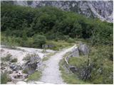 18
18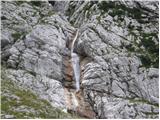 19
19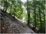 20
20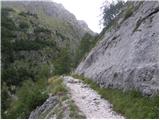 21
21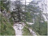 22
22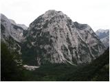 23
23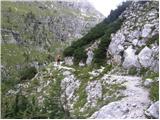 24
24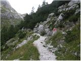 25
25 26
26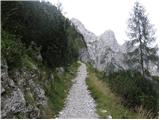 27
27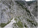 28
28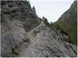 29
29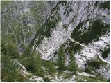 30
30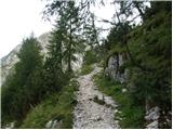 31
31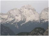 32
32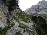 33
33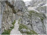 34
34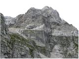 35
35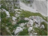 36
36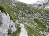 37
37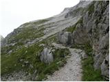 38
38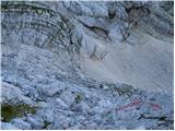 39
39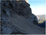 40
40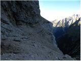 41
41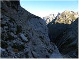 42
42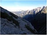 43
43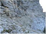 44
44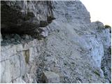 45
45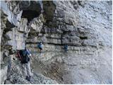 46
46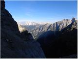 47
47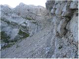 48
48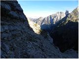 49
49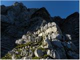 50
50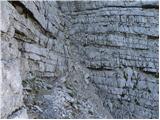 51
51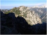 52
52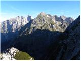 53
53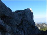 54
54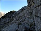 55
55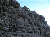 56
56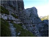 57
57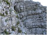 58
58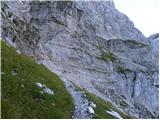 59
59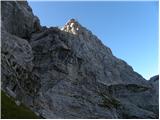 60
60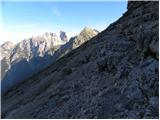 61
61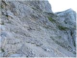 62
62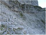 63
63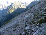 64
64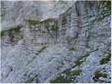 65
65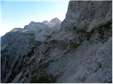 66
66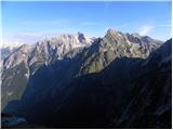 67
67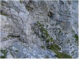 68
68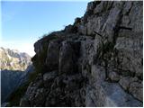 69
69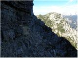 70
70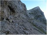 71
71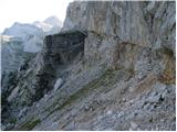 72
72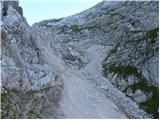 73
73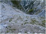 74
74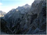 75
75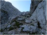 76
76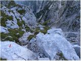 77
77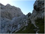 78
78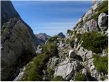 79
79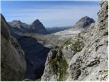 80
80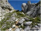 81
81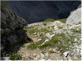 82
82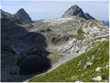 83
83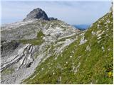 84
84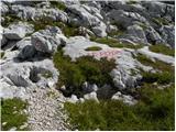 85
85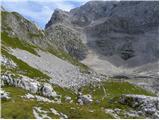 86
86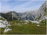 87
87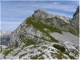 88
88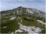 89
89 90
90
Discussion about the trip Zadnjica - Zasavska koča na Prehodavcih (via Mira Marko Debelak)
|
| mary19. 09. 2012 |
Hello! Does anyone maybe have any info regarding this trail, that perhaps walked it in the recent time? How much is the trail secured, in what condition it is,...every information is welcome. Thanks, Lp
|
|
|
|
| IgorZlodej19. 09. 2012 |
Everything is described under "Forum/Conditions".
|
|
|
|
| brinta19. 09. 2012 |
I went on this trail fourteen days ago. The trail is excellent and newly marked, so there is no fear of course if you have no problems with vertigo.
|
|
|
|
| brinta19. 09. 2012 |
It is secured where it is necessary.
|
|
|
|
| brajdo20. 09. 2012 |
On Saturday afternoon it was nicely passable, a couple cm of snow in some sections but with a bit of caution no panic
pics
|
|
|
|
| mary20. 09. 2012 |
Awesome, thanks everyone! 
|
|
|
|
| steyr24. 09. 2014 |
Igor Zlodej, you surely know what the path over Kanjavčeve police is like? Probably some compacted snow patch somewhere? Have you been up there these days?? Thanks and best regards
|
|
|
|
| IgorZlodej24. 09. 2014 |
I haven't been there. But it's fine on Dolič and on Prehodavcih.
|
|
|
|
| andrejp25. 09. 2014 |
End of August we walked the mentioned path and there was only one snow patch inside, which had to be bypassed, and even that wasn't difficult at all, because we got directly back to the path... the rest of the path is normally passable but there's a lot of ,,gravel,, on the path, so caution
best regards Andrej
|
|
|
|
| jakaivancic23. 07. 2018 |
Has anyone been on this path in the last weeks-days? What's the situation with the snowfields?
|
|
|
|
| jakaivancic23. 07. 2018 |
Has anyone been on this path in the last weeks-days? What's the situation with the snowfields?
|
|
|
|
| VanSims15. 10. 2018 |
The path, except at two or three climbing spots, is not technically demanding, but requires (especially in the first part from Doliča) a lot of caution because it is exposed and very littered with scree.
|
|
|
|
| LISAC26. 07. 2021 09:17:37 |
Hi. Does anyone have any information on the condition of the path through Kanjavčeve police from the direction of Dolič towards Prehodavci? Thanks.
|
|
|
|
| darinka426. 07. 2021 10:56:24 |
Before the entrance if coming from Dolič direction, there was at least on 20.7 still a large snowfield. From what I saw, snow was visible in some places. Now I don't know if on the ledges or higher up. But the initial part wasn't trampled.
|
|
|
|
| LISAC26. 07. 2021 21:56:50 |
darinka4 thanks for the information. The plan is only in about a month so I'm just asking a bit about the path condition. Best regards
|
|
|
|
| LISAC23. 08. 2021 07:36:00 |
Hi. Does anyone have more recent information on the condition of the path over Kanjavčeve police from the direction of Dolič towards Prehodavci? Dry or still some snow patches? Thanks.
|
|
|
|
| Victorinox23. 08. 2021 18:50:36 |
I'm also interested in the condition, maybe I'll go on this path tomorrow.
|
|
|
|
| darinka423. 08. 2021 22:49:32 |
On Saturday when heading towards Dolič I saw two coming from this direction across the snowfield at the start of the path and then along the path over the ledges. How passable they are I don't know.
|
|
|
|
| pinkapolonka24. 08. 2021 07:15:46 |
At the start from Dolič there's still one snowfield that can be crossed, further on the ledges the path is normally passable, at one spot the rock is slippery, lots of scree - careful.
|
|
|
|
| LISAC24. 08. 2021 10:44:32 |
pinkapolonka thanks for the super info  Safe return! Safe return!
|
|
|
To post a comment you must log in:
If you do not yet have a username, you must first
register.