Starting point: Žerjav (536 m)
Walking time: 1 h 45 min
Difficulty: easy unmarked way
Elevation gain: 540 m
Elevation difference along the route: 540 m
Map: Koroška 1:50.000
Recommended equipment (summer):
Recommended equipment (winter): ice axe, crampons
Views: 17.100
 | 2 people like this post |
Access to starting point:
A) First, we drive to Šoštanj (to here from Velenje or the Savinja Valley), and then we continue driving towards Črna na Koroškem. Further, the road starts ascending towards the mountain pass Spodnje Sleme (1081 m), which after a few kilometers of winding road we also reach. Next follows a descent through the valley of Javorski potok to Črna na Koroškem, where at the roundabout in the center of the settlement (roundabout in the middle of which is a monument, nearby the bus station and parish church of St. Ožbalt) we continue right in the direction of Žerjav. Further, we drive past the mining museum and then through Mežiška dolina towards Žerjav. In Žerjav after the factory TAB MPI and after the Petrol gas station we cross the bridge over the river Meža, and right behind the bridge we continue right on a somewhat narrower asphalt road in the direction of Uršlja gora, Jazbina and Žerjav. We park at the branch primary school or one of the parking spaces nearby.
B) First, we drive to Ravne na Koroškem (to here from Dravograd or Slovenj Gradec), and then we continue driving in the direction of Mežica and Črna na Koroškem. When we get to the settlement Žerjav (Žerjav is a settlement between Mežica and Črna na Koroškem), just before the main road crosses the river Meža we continue left in the direction of Uršlja gora, Jazbina and Žerjav. We park at the branch primary school or one of the parking spaces nearby.
Route description:
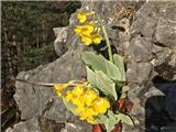
The path which is marked with signposts starts between apartment blocks where on the right side we see a signpost for Dukles. On the macadam road, we ascend a little above the settlement to the house and the meadow. We cross the steep meadow and come to the forest road. On the road, we turn left uphill and in a steep slope we quickly ascend to a sharp turn where we turn right. After a little less than 100 meters on the right side there is a sign for Dukles and the beginning of an unmarked footpath. The footpath ascends quite steeply in zig-zags, and the steepness soon decreases. We soon come to the ridge and views open up on Smrekovec, Raduha and Olševa and Žerjav below us. The path on the ridge is quite narrow, and on the right side it is steeply cut towards Jazbina. After a few shorter steeper parts of the path, we ascend among the heath-overgrown slopes of Pogorevc. The path crosses the slope and soon above and below us we notice rocks, which in spring are full of blooming auricula. On a quite narrow path, we slightly descend to some rocks on the left side and from there in a few minutes we get to the hunting cottage Dukles.
Before the hunting cottage, we turn left and along the ridge we come to the summit of Pogorevc.

Photos:
 1
1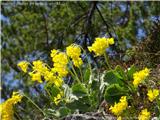 2
2
Discussion about the trip Žerjav - Pogorevc
|
| primozg21. 04. 2017 |
On Easter Monday we went on this tour with mountaineers from PD Prevalje. Avrikelj was beautifully blooming. Report and photos on my blog
|
|
|
|
| Misantrof14. 04. 2018 |
Since I didn't feel like driving around for too long, I set off today in excellent weather to this beautiful sunny ridge, as it's close to home and it's proper to visit it every now and then. On the path, especially in the lower part, there are some tree obstacles, but nothing serious. Due to the location, there's no more talk of snow, it's been replaced by heather in full bloom. I noticed that some societies are planning to view the avrikelj in the coming days, unfortunately only very few specimens are in bloom, you'll have to wait another week or two for the yellowish rocks.
|
|
|
|
| primozg2. 05. 2018 |
In the description of the path to the top of Pogorevc, I made a mistake. Before the hunting hut, we turn left, not right.
|
|
|
|
| Katka1318. 01. 2021 |
Hello.
I read the path description to Pogorevc summit, but it does not match the Pogorevc summit I know. Namely, the sign for the mentioned summit is further from koča Dukles towards Golem vrh. Are there two summits with the same name?
Lp
|
|
|
|
| primozg18. 01. 2021 |
I think there really are two, "Stari Pogorevc" and "Pogorevc". Need to check both... if not sooner, then when avrikelj is in full bloom
|
|
|
|
| lepenatka11. 04. 2024 18:38:00 |
Hello.
Is the avrikelj around the Dukles hut already in full bloom?
|
|
|
|
| bos11. 04. 2024 19:34:08 |
On Tuesday friends were there and everything should be blooming nicely.
|
|
|
|
| lepenatka11. 04. 2024 20:45:10 |
Super.
Thanks for the info.
Regards
Regina
|
|
|
|
| lepenatka15. 04. 2024 15:56:46 |
It's really blooming nicely. Checked on Saturday.
There's also a lot of reeds.
Weather was really summery.
|
|
|
To post a comment you must log in:
If you do not yet have a username, you must first
register.