Zgornje Poljčane - Boč (via Balunjača)
Starting point: Zgornje Poljčane (360 m)
| Latitude/Longitude: | 46,29710°N 15,58340°E |
| |
Route name: via Balunjača
Walking time: 1 h 45 min
Difficulty: partly demanding marked way
Elevation gain: 618 m
Elevation difference along the route: 620 m
Map: Posavsko hribovje (Boč - Bohor) 1:50.000
Recommended equipment (summer): helmet
Recommended equipment (winter): helmet, ice axe, crampons
Views: 101.112
 | 4 people like this post |
Access to starting point:
a) Leave the Ljubljana–Maribor motorway at the Slovenske Konjice exit, then follow the signs for Žiče, Loče, Zbelovo and Poljčane. In Poljčane turn right and drive to Zgornje Poljčane, where we follow the main road to the junction with the side road branching left towards Boč and Planinski dom na Boču. Park above the settlement on the gravel parking area, near the hiking signposts.
b) Leave the Maribor–Ljubljana motorway at the Slovenska Bistrica south exit, then follow the road towards Poljčane and Podčetrtka. In Zgornje Poljčane we follow the main road to the junction with the side road branching left towards Boč and Planinski dom na Boču. Park above the settlement on the gravel parking area, near the hiking signposts.
c) On the Šentjur–Rogaška Slatina road at the Podplat settlement turn left (coming from Rogaška Slatina turn right) towards Slovenska Bistrica and Poljčane. Some ascent follows, after the Pečica pass descent begins. At the start of Zgornje Poljčane settlement turn right towards Boč and Planinski dom na Boču. Park above the settlement on the gravel parking area, near the hiking signposts.
Route description:
From the starting point head onto the path continuing along the Skodovec valley. Beside it are signs for Boč and Detička path (right path over Baba), we ascend along it first gently, a little further moderately. After a few minutes cross the asphalt road leading towards Dom na Boču and continue the ascent along the valley. The slopes above it gradually become steeper, and the path becomes steeper too. Higher up the marked path turns right onto the slopes across which we ascend transversely to the ridge; we reach it slightly above the indistinct summit of Baba (594 m).
Here go left and at Maistrov kamen reach a cart track which we merely cross (right to Dom na Boču). A few minutes' ascent through the forest follows, then past Finžgarjev križ we reach the gravel road (here the path from Dom na Boču joins from the right), which we follow left to the nearby turning area.
Continue left along the rutted, reinforced and locally fenced path which soon brings us to a junction where we leave the usual easy path to Boč. Head left towards the climbing path and the path via Balunjača. A short, fairly level traverse to the left to the cliffs follows, where the first fixed protection appears. The path is not particularly demanding but is especially in spring and after rain exposed to falling rocks.
At the start of the secured section a very demanding secured path to Boč branches right, we continue straight towards the path via Balunjača. A traverse up the steep slope follows, where special caution is needed especially when wet. After the next secured section we arrive at Balunjača cave, just a few dozen steps further there is another cave. The steepness of the slope above the caves eases somewhat, the path turns right and ascends transversely above the steep section. When the terrain levels out, the climbing path joins from the right.
Continue slightly left and at the red hiking signs join the usual path. Continue following the markers to the fenced military area which we bypass on the right side. For a short time we walk without major changes in elevation, then ascend again and quickly reach the summit of Boč with the viewpoint tower. In fine weather it is worth climbing it, as a magnificent view opens up in all directions.
Starting point - Brusovnice 1:05, Brusovnice - junction below Balunjača 0:10, junction below Balunjača - junction above Balunjača 0:15, junction above Balunjača - Boč 0:15.

Along the route: Finžgarjev križ (704m), Brusovnice (741m), Razpotje pod Balunjačo (808m), Razpotje nad Balunjačo (900m)
Photos:
 1
1 2
2 3
3 4
4 5
5 6
6 7
7 8
8 9
9 10
10 11
11 12
12 13
13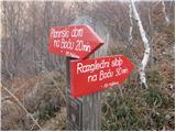 14
14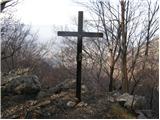 15
15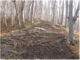 16
16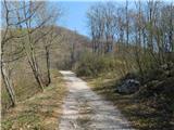 17
17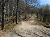 18
18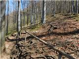 19
19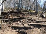 20
20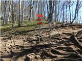 21
21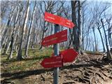 22
22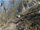 23
23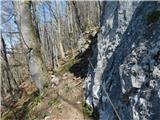 24
24 25
25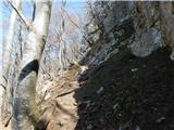 26
26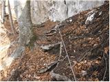 27
27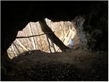 28
28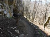 29
29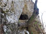 30
30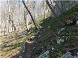 31
31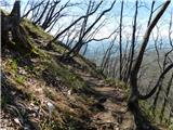 32
32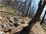 33
33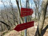 34
34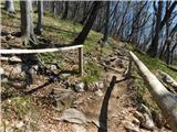 35
35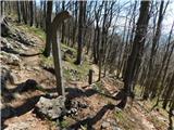 36
36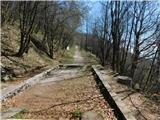 37
37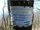 38
38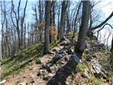 39
39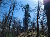 40
40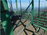 41
41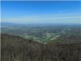 42
42
Discussion about the trip Zgornje Poljčane - Boč (via Balunjača)
|
| Gost10. 02. 2008 |
We had a very good time..the day was nice, sunny, just right for a trip to the mountains ..from Boč you can see more than half of Slovenia, and also parts of Austria and Croatia ..from Boč you can see more than half of Slovenia, and also parts of Austria and Croatia
|
|
|
|
| Luciano679. 11. 2009 |
I missed the path via Balunjačo somewhere, I reached the top via Baba. I didn't notice the sign for Balunjačo.
|
|
|
|
| nataskag1. 05. 2010 |
Beginners might be misled by the relatively low elevation, but the path ascends continuously, so it's not that easy. We had a wonderful trip.
|
|
|
|
| klm12. 09. 2010 |
Excellent route, wonderful nature. Under the tower on the north side spotted a herd of mouflons. At several places the path can be connected with the one via Baba, just if one is not too fast and misses the unmarked junction. At the very top there are plenty of JLA remains and I always wonder what is hidden inside. Undoubtedly they drilled into it... I descended via an unmarked path that branches off quite invisibly from the first hairpin of the forest (military road) that leads to the top of Boč from below Podboča (this one is well maintained for military needs and suitable for cyclists; from Podboča 11 km, 700 m elevation gain).
In short, the unmarked path soon becomes quite distinct and winds along the northwest ridge of Boč, past numerous rocky steps that need to be descended. In places it is quite steep, but due to the peace and diversity of nature very interesting. Then we reach a junction or a crossing horizontal path. If we turn left, it soon leads to the marked path we ascended, if we turn right it takes us to the aforementioned forest road from Podboča to Boč. In early summer the north slopes here are completely overgrown with wild garlic. When we reach the mentioned road, another approx. 2.5 km of walking or running to the starting point awaits us.
|
|
|
|
| damijanp30. 10. 2010 |
Some snapshots from yesterday's trip to Boč, clad in autumn colors, are at:
Boč
|
|
|
|
| klm30. 10. 2010 |
damijanp! Crazy photos! I'm completely stunned. I've been to Boč countless times, but never experienced such a wonderful view! Especially not on Grintovci! Crazy!
|
|
|
|
| damijanp30. 10. 2010 |
Thanks. Yesterday the view was really fantastic. I've also been to Boč many times, but haven't experienced such a view yet. Plus the autumn colors that put the icing on the cake.
|
|
|
|
| klm30. 10. 2010 |
Great damijanp, I checked out your (Your) photo gallery and in it... very good and some extremely interesting photos!
|
|
|
|
| damijanp30. 10. 2010 |
Thanks again. "Your" will do fine.
|
|
|
|
| juki6. 11. 2010 |
Today I hesitated between Šmohor and Boč, your photos excited me, let's go to Boč.
|
|
|
|
| Luciano676. 11. 2010 |
Just today I climbed to Boč via Balunjača and the route is simply gorgeous. Highly recommended.
|
|
|
|
| klm7. 11. 2010 |
Yesterday Urška and I climbed this path to the summit. The wind quickly blew away the remaining beech leaves along the trail, making the hike pleasantly rustling. There were quite a few cars with Kranj license plates parked at the parking lot, and the parking lot has a new addition: a decade-old Gorenje washing machine, unfortunately without an electric motor. Despite the surprising crowd of cars at the start, we only met a handful of people, as they get lost among the multitude of paths. Today was the same on the Styrian end, at least weather-wise. In the morning the summit was capped in fog, a reliable sign of worsening weather. But the wind dispersed it in the following hours. Then the sun even began to illuminate the northwest slopes. That meant only one thing: I quickly changed into running gear and dashed to the top. Surprisingly, another crowd of "Kranj" drivers at the parking lot. The view from the top revealed why so many Kranj residents in this area, as the sky to the west was completely darkened. Now I'm on "Kranjska" too. As I conclude this, thick rain clouds completely obscure the nearby Grintovci.
|
|
|
|
| juki8. 11. 2010 |
On Boč it was beautiful on Saturday, especially because we looped the trail to the hut on Boč.
|
|
|
|
| Pandora12. 03. 2011 |
Hi!
Today I went on this path to Boč. I have been to Boč many times before, but this time I went alone "to the mountains" for the first time. It's different without company, but super because you see so many new things that you otherwise wouldn't notice. The weather was great and even the wind couldn't spoil the excellent trip. The descent from the hut through Baba to the car was phenomenal.
|
|
|
|
| Matjaz_652. 05. 2011 |
some of my photos ... with ascent over Baba and Balunjača ... and descent along shady path and over Baba
from the starting point we can actually ascend via the children's path ... which joins above the hut on the path over Balunjača ... or over Baba to the hut ... and further over Balunjača or shady path 
|
|
|
|
| jvali26. 11. 2011 |
We three are heading to Boč. I would like a circular path that includes Baba and Balunjača as well as the hut on Boč. Is that even possible? Really thanks for the answer.
|
|
|
|
| slainter26. 11. 2011 |
The trail to Boč can be looped: park in Zgornje Poljčane at the parking lot. Hiking signs direct you to Detičkovo or the path via Baba. Both paths merge and lead to the hut and Boč summit. If you want to go via Balunjača, keep left; otherwise, the trail is well marked so you won't have problems. These days Boč summit was sunny every day, the middle section quite wintry, and I hope you'll enjoy the beautiful weather tomorrow too. Regards
|
|
|
|
| bruny26. 11. 2011 |
I recommend following the original trail description and photos to the tower and then descend via the hiking path continuing from the tower, excellently marked to the mountain hut...refreshment at the hut and short rest then descend the entire Baba into the valley. Nice and complete loop tour....Adding GPS track from tower to parking...
GPS Tower - hut on Boč - Baba
Regards and lots of enjoyment on Boč
|
|
|
|
| pohodnik3828. 11. 2011 |
Yesterday on Sunday 27.11. I took advantage of the nice sunny day to visit Boč and a nice circular tour...up through Balunjača down back to the starting point past the mountain hut and through Baba. At the top very nice views from the tower such that I haven't had despite the very strong wind...some photos here for viewing.
|
|
|
|
| pohodnik381. 12. 2011 |
the view is such that your heart rejoices all the way to the Kamnik Alps video
|
|
|
|
| Kokta25. 12. 2011 |
Beautiful sunny day on the wonderful Boč. The path is very icy and requires very careful steps, especially on the descent. I warmly recommend hiking poles, because crossing some sections without them is very difficult. At the viewpoint tower there is a stamp, which is just one smudge. In Dom na Boču they don't have it, because it was stolen from them and they are waiting for a new one. Overall a nice hike with a beautiful view from the top of the viewpoint tower.
|
|
|
|
| Domch6. 04. 2012 |
30.03.2012 I visited it for the first time. The trail is easy and pleasant, at the end the path is enlivened by caves. At the top you have to first avoid the SV fence which has enclosed everything far and wide. For the view the observation tower serves. No view that day due to thermals in the air. Summit logbook is missing.
|
|
|
|
| Janiel7413. 05. 2012 |
What about the stamp? Is it at the top?
|
|
|
|
| pohodnik3814. 05. 2012 |
The stamp is at the top on the side by the stairs when going to the observation tower
|
|
|
|
| Janiel7419. 05. 2012 |
Today double dose First over Balunjača to Boč, then past PD Boč and Babe back to the start. Then to Lukov dom and up to Ribniška koča Nice pleasant sunny day!
|
|
|
|
| lidika22. 06. 2012 |
Since we have two small children, I'm interested in how far we can go by car and how much walking is left to the viewpoint tower?
|
|
|
|
| Keko22. 06. 2012 |
You can drive by car to the hut on Boč, from where there are still 280 elevation meters to the viewpoint tower, on a moderately steep path through the forest. With two small children, say about a good hour of walking, otherwise a good half hour for an average hiker.
|
|
|
|
| pohodnik3824. 03. 2013 |
Yesterday 23 March on this path, conditions without peculiarities.... today it's already different.
VIDEO
Best regards! Tone
|
|
|
|
| zabava16. 04. 2014 |
I've already been to Boč twice during Easter time, and where are the Easter flowers. I didn't find them.
|
|
|
|
| otiv16. 04. 2014 |
Because they have already wilted. This year vegetation is ahead by 14 days, as experts say.
Good luck next year!
|
|
|
|
| brina16. 04. 2014 |
this year it bloomed in mid-March
|
|
|
|
| acjom16. 02. 2016 |
Quite often at the top of Boč, especially since the via ferrata leads to the top ... recommended  . But I miss the summit logbook and ask PD Poljčane for an explanation why there is no book, it's nice to be able to sign when you reach the top . But I miss the summit logbook and ask PD Poljčane for an explanation why there is no book, it's nice to be able to sign when you reach the top
|
|
|
|
| jager00730. 10. 2016 |
The summit logbook has been full for some time, there is no stamp at the top (it's in the Mountain Hut). Otherwise, it's a nice trip.
|
|
|
|
| rokjohan131. 10. 2016 |
I don't understand why one should sign the log at the summit. Especially if you go up there multiple times a month. If everyone who goes up signed, many would need their own book. Especially those who go up every day.
|
|
|
|
| sirt131. 10. 2016 |
You obviously don't understand the essence of signing in! Everyone should sign! The entry in the book and precise information where you're going next is of great help in case of search, if something happens and you're missing.
|
|
|
|
| rokjohan131. 10. 2016 |
In the mountains, signing in is really welcome, especially on climbing paths. On easy paths where there are 200 people a day, I really don't see the point of signing. No offense. My opinion.
|
|
|
|
| jprim1. 11. 2016 |
Rokjohan1
Yes, even those who go there every day sign in.
Regards!
|
|
|
|
| golica8. 03. 2019 |
please for info, pasque flowers are blooming, I haven't been to Boč yet, and I don't even know exactly where they are. Thanks
|
|
|
|
| kkac8. 03. 2019 |
I heard on the radio that they are around the mountain hut on Boč.
|
|
|
|
| golica9. 03. 2019 |
If anyone is interested in pasqueflowers, was on Boč today,
only a couple of pasqueflowers, but they will bloom in about a week or 10 days.
|
|
|
|
| MEHOVO10. 03. 2019 |
Hello GOLICA. Your statements are not accurate. In the fenced area there are already 10 blooming pasqueflowers,..three more will bloom outside the fenced,..(fenced with stones) in a couple of days,..in ten days, it will be hard if any more will bloom,..
|
|
|
|
| golica11. 03. 2019 |
I'm correcting myself/apologizing, we saw a couple in the enclosure, but I really don't know how quickly they bloom. Thanks for the correction
|
|
|
|
| Eva198810. 05. 2021 09:58:22 |
I think you could update the pictures here a bit, and one trail on which I started is missing (educational trail) otherwise yesterday walked trail, really nice trail, steepness doesn't let up but on the viewpoint tower at the top the effort is rewarded, fantastic view
|
|
|
To post a comment you must log in:
If you do not yet have a username, you must first
register.