Almost 2 metres of snow already in the high mountains
23.11.2010
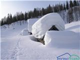
From Sunday to Monday morning there was cloudy weather with precipitation. The snow line was in the Julian Alps locally around 800 m, elsewhere higher, even above 1500 m. The heaviest precipitation fell in the Julian Alps and the western Karawanks. There 15 to around 50 cm of snow fell, depending on elevation. The snow was dry in the high mountains, wet below around 1800 m. Most of the time a southwesterly wind blew, creating wind slabs.
In the high mountains of the Julian Alps there is up to around 190 cm of snow at 2500 m, up to around 40 cm at 1500 m. Elsewhere in our mountains there is around 10 cm at 1500 m, considerably more on the summits. The snowpack is soft and powdery. There are many wind slabs in the high mountains, wind-exposed spots are quite scoured.
Avalanche danger is currently level 3 in the high Julian Alps, elsewhere 1 to 2, depending on elevation. In the high Julian Alps and partly in the western Karawanks loose snow avalanches can release from steep slopes, and snow can be quickly triggered by additional stress especially on wind-loaded snow and steeper slopes.
Until Friday morning it will mostly be dry. Freezing level around 900 m. The snowpack will settle a bit, but due to low temperatures it will not transform much. On Friday it will snow again, mostly to the lowlands.
Next report issued on Friday, 26 November.
General avalanche danger is considerable, i.e. level 3 on the European five-level scale.
Source: ARSO