Snow conditions 13.1.2023
13.01.2023
General danger level - Friday, 13. 1. 2023
Danger is level 2 on the European five-level scale - MODERATE.
Main problem: wind slab, weak layers, new snow
Danger pattern: Cooling after warm weather / warming after cold
Risk assessment
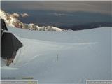
Avalanche danger above about 1700 m is MODERATE, level 2, lower down SLIGHT, level 1. In the high mountains, areas with wind slab are particularly dangerous, where under minor load you can trigger small to medium-sized slab avalanches. In the mid-mountains, the snowpack is stable. Above the forest line, there are numerous wind-scoured and icy areas, so risk of slipping.
Snow conditions
In the mid-mountains there is little snow, mostly 20 to 50 cm. With elevation, the snowpack depth increases rapidly. Snow is crusty and heavily wind-formed. There are many wind slab areas, more dangerous in the high mountains where more snow fell in the last snowfall and Tuesday's north wind drifted it onto south slopes. In sheltered high mountain locations, some light snow remains.
Forecast weather evolution
Friday mostly cloudy. Weak to moderate westerly winds. Temperature at 1500 m around 0, at 2500 m around -4 °C. Night to Saturday transient minor showers, a few cm snow possible. Saturday morning mostly clear, afternoon some cirrus clouds. Initially weak to moderate northerly, afternoon southwesterly. Sunday clouding over, foggy, especially in hills of northern Primorska and Notranjska and in western and southern Julian Alps minor precipitation, minor amounts possible also in Kamnik-Savinja Alps. Snowfall limit initially around 1200 m. Strong southwesterly wind. Temperature at 1500 m and 2500 m around 0 °C. Night to Monday and Monday expect abundant snowfall, stopping quickly by morning. Most precipitation in western half of Slovenia, in mountains possibly more than 50 cm snow.
Trend in snow conditions
Avalanche and snow conditions in high mountains will change only slowly until Sunday inclusive. Danger persists due to numerous deposits on all ridge and saddle sides, and also due to weak layer under new snow. In mid-mountains snow will settle during day, especially on sun-facing slopes, and freeze at night. Crust will strengthen. Avalanche release danger will INCREASE markedly due to abundant snowfall night to Monday.
Next publication: Monday, 16. 1. 2023
Source: ARSO