Snow conditions 26.11.2010
26.11.2010
From Tuesday it was mostly dry and also cold in the mountains. The snow line was at about 900 m above sea level. The snow cover settled somewhat. Transformation was slow due to low temperatures.
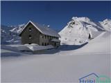
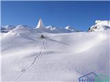
In the high mountains of the Julian Alps there is about 190 cm of snow at 2500 m, and about 40 cm at 1500 m. Elsewhere in our mountains there is about 5 cm of snow at 1500 m, more on the peaks. The snow cover is mostly soft and loose. There are many wind slabs in the high mountains, wind-exposed areas are quite scoured.
Avalanche danger is currently 2nd degree in the high mountains of the Julian Alps and on the peaks of the Karawanks and Kamnik-Savinja Alps, elsewhere 1st degree. An avalanche can be triggered by additional load especially on areas with wind-blown snow and on steeper slopes.
Today it will start snowing in the mountains. By Saturday morning 15 to 25 cm of snow will fall, which the southwesterly wind will mainly blow into wind slabs in the high mountains. The snow will be dry and will bond relatively well with the mostly soft base. Avalanche danger will increase somewhat in the high mountains. On Saturday during the day it will be dry, on Sunday it will gradually start snowing again. In between it will temporarily warm up a bit, the snow line will rise to about 1000 m above sea level for a short time. The new snow will not settle much nor transform by Sunday's snowfall. By Monday morning up to 50 cm of snow may fall. Avalanche danger will increase.
The next report will be issued on Monday, 29 November.
General avalanche danger is moderate, i.e. 2nd degree on the European five-degree scale.
Source: ARSO