Snow conditions 6. 3. 2026
6.03.2026
Avalanche forecast
Friday, 6. 3. 2026
Danger level Friday, 6. 3. 2026 at
Danger level 2 – moderate
Southern Julian Alps, Central Julian Alps, Eastern Julian Alps, Western Julian Alps, Kamnik Alps, Savinja Alps and Carinthia, Western Karawanks, Central Karawanks
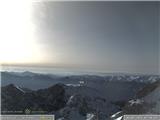
Avalanche danger in the high mountains is moderate
In the high mountains there are still some areas with wind-packed snow where under greater load a slab avalanche can be triggered. Weak layers in the snowpack also pose a problem. If the load exceeds the strength of the deeper weak layers, a deep and large avalanche can be triggered. There are many such weak layers especially on shady slopes above the forest.
Snow cover
Danger patterns
dp.1: deep persistent weak layer
dp.10: spring conditions
The snow cover freezes overnight, during the day it softens especially on sun-exposed slopes. The snow layers have already bonded quite well with each other. With warming, snow on sun-exposed aspects transforms more intensively, this process is less pronounced on shady aspects. Deep in the old snow cover below the surface, multiple weak layers of facets and rounded grains are forming.
Weather
Clear in the morning and forenoon, during the day some cumulus clouds will form above the summits. In the high mountains a light wind from westerly directions will blow, elsewhere mostly from easterly directions. Downslope winds will be somewhat more pronounced. At midday, temperature at 1500 m around 5 °C, at 2500 m around 0 °C.
Outlook
Weather and avalanche conditions will be similar in the coming days.
https://www.hribi.net/snezne_razmere_v_gorah Source: ARSO