Snow conditions in the area of the Municipality of Tržič 10.1.2022
10.01.2022
Avalanche Bulletin 21, Monday 10.1.2022 at 6:00 for the area of the Municipality of Tržič.
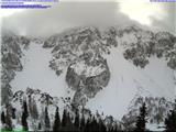
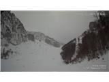
General avalanche danger in the area of the Municipality of Tržič above 1800 m a.s.l. is 3rd degree on the five-level European scale, lower it is 2nd degree on the five-level European scale.
Above 1800 meters, there are still areas with wind-packed snow. In the high mountains yesterday and overnight today, a strengthened north wind was blowing, transporting snow and building new slabs. Snow was depositing on existing slabs, more of which are in narrow gullies. Certain ridges are scoured to bare or icy ground. Also lee slopes are scoured to bare or hard ground. The snowpack has begun to metamorphose and settle. On lower parts it is already relatively well bonded.
Below approximately 1800 meters, the snow that fell last week fell on a crusted base. On these parts it is fairly well bonded to the old snow surface. Here a thicker ice layer has formed. Below this ice layer, the snow is still moist or wet. The north wind has also transported snow here and built new slabs and smaller drifts. Because the air temperature was low, the snow is dry. The snowpack is settling and metamorphosing. The increased air humidity also affects the metamorphosis, which will still be quite high today.
Today it will be cloudy. Air temperature at 1500 meters will be around -4°C, north wind up to 50 km/h. At 2000 meters, air temperature during the day around -8°C, strengthened to strong north to north-west wind up to 70 km/h. Air humidity at 2000 meters around 85%. Tomorrow clear with similar air temperatures. Strengthened north to north-west wind blowing.
In the high mountains, north wind will also blow today and tomorrow, still transporting snow and building new slabs and drifts. The wind will deposit snow on existing slabs. On these parts you can already trigger slab avalanches with additional snowpack load. Due to slightly higher air humidity, the snowpack will metamorphose and bond faster. Ridges are hard and icy. Be careful, as there is slip hazard on these parts. Also at lower elevations, the wind will build slabs. Generally below 1800 meters the snowpack is somewhat more bonded or coherent with the old snow surface, but there are still areas with wind-packed snow. Be careful, especially on slopes with inclination over 30°, where with additional greater snowpack load you can trigger slab avalanches. Conditions in the high mountains are still demanding and tricky, so be careful. Avalanche danger will decrease only very slowly.
Source:
https://www.zvsp.si