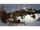
Snow conditions in the area of the Municipality of Tržič 12.2.2023
12.02.2023
General avalanche release risk in the Municipality of Tržič area above 1700 meters is MODERATE 2nd degree, below 1700 meters 1st degree on the five-level European scale. On Monday during the day above 1300 meters avalanche release risk will be 2nd degree.
Avalanche conditions have not changed much since Thursday. Low air temperatures and low air humidity have greatly slowed the snowpack transformation and settling process. Today, Saturday, it has warmed slightly. Especially on sun-exposed sides the snow was slightly more moist on the surface. On sufficiently steep sun-exposed grassy slopes the snow has become somewhat more unstable, especially where the snowpack was already cracked.
In narrow high-mountain couloirs and shady mid-mountain locations there is still locally light snow, but conditions vary by location. Ridges are wind-packed to hard snow base or ice base. On these parts there is slipping risk. Wider shady slopes are hard. Between old snow or snowpack and newly wind-deposited snow there are weak layers present.
Sunday morning partly clear. Air temperature at 1500 meters midday around 0°C, weak S wind blowing. At 2000 meters around -3°C, north wind up to 40 km/h. Monday clear. Air temperatures slightly higher. At 1500 meters around +5°C, at 2000 meters around +3°C.
On shady locations avalanche conditions will remain almost unchanged. In narrow couloirs snow will remain light locally. Between old snowpack and newly wind-deposited snow there are weak layers. On these parts be careful, as even with additional major loading you can trigger an avalanche. Wide slopes will remain hard. Certain narrow couloirs and wide slopes will remain hard and stable.
On sun-exposed locations snow will surface-soften during the day, especially on steep slopes. On some slopes cracks are visible. Great caution needed during the day when spontaneous release can occur. Do not stay under these slopes. At night snow will refreeze and crust will form.
On ridges snow surface will be hard, sometimes icy. On these parts slipping can occur. Snowpack will due to higher high-mountain temperatures start settling faster and become even more stable.
On Monday air temperatures will rise slightly more. Zero isotherm height around 2800 meters. During the day avalanche release risk on sun-exposed locations above 1300 meters 2nd degree. Do not stay under sun-exposed steep slopes. On certain slopes snow cracks are also visible.
Source:
https://www.zvsp.si