Snow conditions in the area of the Municipality of Tržič 25.2.2022
25.02.2022
Avalanche Bulletin 42, Friday 25.2.2022 at 7:30 for the area of the Municipality of Tržič.
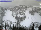
General avalanche danger in the Municipality of Tržič area above 1500 meters is degree 2 on the five-degree European scale, lower down it is degree 1.
On Monday some new snow fell. In the high mountains it was up to 15 cm. Snowfall was accompanied by moderate to strong north wind, which transported snow and built wind slabs and cornices. Avalanche problems formed on south slopes, below ridges and in gullies. Some ridges are icy and wind-scoured to hard base. In the mid-mountains it first rained. On these parts new snow is better bonded to the old snowpack. Wind also blew here and built wind slabs and cornices, but areas are small. On Tuesday strong to gale-force north wind continued transporting snow and building new cornices. Ridges are further wind-scoured and icy. On Wednesday and Thursday snow settled and metamorphosed. Metamorphosis was faster on shady slopes as snow melted during the day and froze at night. A crust formed. Snow also metamorphosed on sunny slopes. In high mountains on sunny slopes there are still smaller areas with wind-drifted snow.
Today in the mountains above Tržič it will be partly clear in the morning, in the afternoon cloudy and snow will start. Snow line around 900 meters. In high mountains up to 10 cm snow possible. Snowfall accompanied by strong S to NE wind. Air temperature at 1500 meters around -4°C, at 2000 meters around -6°C. Tomorrow partly clear. Tomorrow and Sunday strong to gale-force north wind in high mountains.
Overall, the old snowpack is well stabilized. In the last two days daily temperature fluctuation was large, which is good for snowpack metamorphosis.
Snow falling this afternoon will not greatly affect avalanche danger change. Strong north wind during and after snowfall will transport snow and build wind slab areas. Much new snow will also be blown away, especially on ridges and wider slopes. On areas with drifted snow locally higher avalanche danger possible, which due to low temperatures will persist until Monday. Snow will accumulate also under north faces and in narrow gullies. Be careful there, as additional minor load can trigger avalanche.
Source:
https://www.zvsp.si