Snow conditions in the mountains 1.12.2010
1.12.2010
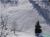
On Monday it was still snowing in the mountains. In the Julian Alps up to 45 cm of snow fell in some places, mostly from 15 to 20 cm, in the eastern Karawanks and on Pohorje up to 5 cm. On Tuesday it was dry, in the night to Wednesday it started snowing again and by morning 5 to 15 cm of snow fell. The snowpack has only settled slightly by today. It transformed slowly due to low temperatures. The wind transported snow into windslabs on exposed places.
In the Julian Alps at 2500 m there is currently up to around 260 cm of snow, at 1500 m up to around 120 cm. Elsewhere in our mountains at 1500 m around 65 cm of snow. At 1000 m above sea level there is 30 to 50 cm of snow. The snowpack is soft and loose. There is a lot of windblown snow.
Avalanche danger is 3rd degree in the high mountains of the Julian Alps and on the ridges of the Karawanks and Savinja Alps, elsewhere 2nd degree. An avalanche can be triggered quickly by additional stress especially at places with windblown snow and on steeper slopes.
From steeper slopes we also expect spontaneous release of medium-sized loose snow avalanches, as well as slab avalanches.
Today it will still snow. By evening 10 to around 40 cm of snow will fall, most in the western Julian Alps. Tomorrow there will also be precipitation mainly in the western Julian Alps and the foothills. Today and tomorrow it will temporarily warm up slightly, the freezing level will rise to around 1300 m above sea level, further east also to around 1500 m. Today the layer of warmer air will temporarily reach higher altitudes, lower down it will remain below zero. Snow will remain dry only in the high mountains, where it will transform and settle more slowly than at lower elevations. Avalanche danger will not decrease for now.
The next report will be issued on Friday, 3 December.
General avalanche danger is considerable, i.e. 3rd degree on the European five-level scale.
Source: ARSO