Hike.uno
Hike.uno
Login
Login
Username:
Password:
Login
Not registered yet? Registration.
Forgot password?
Feldalmhütte

Feldalmhütte

Country: Austria
Latitude/Longitude: 46,9954919°N 14,6242633°E
Altitude: 1751 m
Type: Mountain hut
Weather forecast:
Su
Mo
Tu
We
Th
Description:
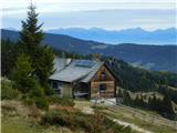
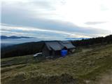
Feldalmhütte is a mountain hut at an altitude of 1751 meters and is part of the Lavanttal Alps. The mountain hut is located 5 km south-southwest from the center of Lavantegg and 6 km east from the center of Sankt Martin am Silberberg. The nearest peak is Pressner Alpe, which is located 0.4km jugo-jugozahodno. West of the mountain hut is the valley Görtschitztal.
Images:
Feldalmhütte Feldalmhütte
Show map
Points in the vicinity:
Detailed descriptions
Pressner Alpe (1836m)
0,4 km south-southwesterly
Zöhrerkogel (1874m)
0,8 km west-northwesterly
Angerlkogel (1774m)
2,5 km south-southeasterly
St. Martiner Hütte (1710m)
2,8 km west-northwesterly
Webcams
Klippitztörl
6,5 km southeasterly
Klippitztörl Straße
7,9 km southeasterly
Obdach
8,4 km north-northeasterly
Panoramas
Wildsee (1981m)
5,8 km north-northwesterly
Fuchskogel (2214m)
6,5 km north-northwesterly
Köhlerhütte (1855m)
7,2 km north-northwesterly
Geierkogel (Seetal Alps) (2185m)
8 km north-northwesterly
Rothaidenhütte (1836m)
8,4 km north-northwesterly
Starting points
Waldheimhütte
6,8 km northerly
St. Anna am Lavantegg
6,9 km northeasterly
Klippitztörl
7,6 km south-southeasterly
Seetalerhütte (Klippitztörl)
7,7 km southeasterly
Schwarzkogelhütte
7,9 km southeasterly
         
Copyright © 2026 Hike.uno, Terms of use, Privacy and cookies